Below is the JIC Overview map which shows the three fires: Chetco Bar, High Casacade Complex and Miller Complex. Since the complexes are made up of many fires, the circles enclose the fires contained in that complex. Those three fires are the only ones for which this JIC is providing information. The Daily JIC Summary is posted below the map.

For a downloadable, emailable PDF of this map, click here.


JIC SUMMARY
August 31, 2017
OVERVIEW
There has been a tremendous amount of interagency collaboration on the three large fires in
southwest Oregon. Numerous state, federal, and local agencies are working together to suppress fire in an extremely busy and difficult fire season. These agencies work together prior to fire season to build relationships, set expectations and develop plans and operating procedures which results in a much more coordinated and safe response to fires.
Labor Day weekend is fast approaching and the public should check the links below for area closures, and use restrictions to better help plan any weekend outings on public lands:
Area Closure Information: Several large wildfires are burning in southwest Oregon. Area closures have been implemented on the Rogue River-Siskiyou National Forest and BLM lands. Find these closures on inciweb: https://inciweb.nwcg.gov/incident/article/5385/39248/.
Use Restrictions are in place for public health and safety: Public Use Restrictions have been increased across the Rogue River-Siskiyou National Forest. No campfires are allowed.
Oregon/Washington Firefighters and Support Personnel Statistics:
- There are 9,600 firefighters and support personnel mobilized in Oregon and Washington.
- There are 19,000 firefighters and support personnel mobilized nationwide.
- The largest fire/complex to date in Oregon is the Chetco Bar for a total of 128,738 acres.
- The largest fire/complex to date in Washington is the Silver Dollar at 30,984 acres.
Closure Information
Several large wildfires are burning in southwest Oregon. Area closures have been implemented on the Rogue River – Siskiyou National Forest and BLM lands. Fire restrictions are in place. https://www.fs.usda.gov/alerts/rogue-siskiyou/alerts-notices
FIRES AT A GLANCE
FIRE RESOURCES
|
CHETCO BAR
|
MILLER
|
HIGH CASCADES
|
TOTAL RESOURCES
|
Acres
|
131,197
|
14,239
|
26,331
|
171,767
|
Personnel
|
1,427
|
550
|
624
|
2,601
|
Crews
|
37
|
11
|
14
|
62
|
Engines
|
78
|
37
|
22
|
137
|
Dozers
|
19
|
6
|
2
|
27
|
Water Tenders
|
21
|
5
|
6
|
32
|
Helicopters
|
7
|
1
|
7
|
15
|
For more information on what the evacuation levels mean, visit: http://www.rvem.org/general-evacuation-information.html
Chetco Bar Fire
Fire Stats:
Start Date: July 12, 2017 Cause: Lightning Acres: 131,197 acres Total Personnel: 1,427
Current Situation
Oregon State Fire Marshal task forces continue assessing structures in the Winchuck and Pistol River areas; preparing homes for the possibility of fire being pushed into the area by the coming winds.
South of the fire, crews will work on constructing alternate lines and tying in the section where fire crossed Emily Creek. On the northwest perimeter, crews will bring line north to steer fire north and east. A contingent of firefighters will work from a remote camp near Agness; reducing travel time. On the eastern flank, firefighters are looking for opportunities to use fire line previously constructed during the 2002 Biscuit Fire while assessing structures along the Illinois River just east of the Wilderness. An increased presence of fire traffic can be expected throughout Illinois Valley.
South of the fire, crews will work on constructing alternate lines and tying in the section where fire crossed Emily Creek. On the northwest perimeter, crews will bring line north to steer fire north and east. A contingent of firefighters will work from a remote camp near Agness; reducing travel time. On the eastern flank, firefighters are looking for opportunities to use fire line previously constructed during the 2002 Biscuit Fire while assessing structures along the Illinois River just east of the Wilderness. An increased presence of fire traffic can be expected throughout Illinois Valley.
Evacuations
Evacuations are in place in Curry County. They are being continually evaluated and adjusted to reflect developing conditions and resource availability.
Red Cross is moving its evacuation shelter in Gold Beach to the Curry County Fairgrounds showcase building at 29392 Ellensburg Avenue. Tolowa Dee-ni’ Nation is also operating a shelter at The Xaa-wan’-k’wvt Village & Resort (old Ship Ashore) RV Park located at 12370 Highway 101 North in Smith River.
Residents are encouraged to monitor the interactive evacuation map for changes: Evacuation Map

High Cascades Complex
[Active: Branch I (Blanket Creek, Spruce Lake); Branch II (Broken Lookout, Pup, Paradise, Windy Gap.]
Fire Stats
Cause: Lightning; Sherwood Fire under investigation Complex Size: 26,331 acres Total Personnel: 624
Complex Containment: 37%
Current Situation:
Today firefighters will continue preparing the Union Creek area to protect it against the Broken Lookout Fire. Across the High Cascades Complex, crews will continue to construct indirect fire line along forest roads and Hwy 68 (the Blanket Fire). They will also be looking for opportunities to conduct tactical burnout operations at various locations across the complex and to mop up fire line. Crews have nearly completed work along Highway 62 and have conducted a number of successful burnout operations.To improve firefighting productivity, two spike camps will be set up; one at Woodruff OHV Play Area and the other near Fort Klamath. Today will be hot and dry. Strong east winds and low relative humidity tonight will contribute to a Red Flag Warning in effect beginning tonight through tomorrow morning. These conditions may lead to very active fire behavior, with increased torching and spotting possible.
A community meeting is planned at the amphitheater in Union Creek Campground on Friday, September 1 at 6 pm. Fire managers and agency officials will discuss the status of the fires and planned operations.
Evacuations: A Level 1 Evacuation Notification was issued yesterday for the Union Creek area by the Jackson County Sheriff’s Office. No changes have been made to the Level 1 Evacuation Notification at Mazama Village in Crater Lake National Park.
Closures: The Rogue-River Siskiyou National Forest has expanded the area closure west of Hwy 62 and 230 around the Broken Lookout, Windy Gap, Paradise and Pup fires. This Closure has closed all OHV trails on the High Cascades Ranger District. For specific information visit: https://inciweb.nwcg.gov/incident/5503.
 |  |  |
Miller Complex
[Active: Branch I (Creedence, Bigelow); Branch II (Burnt Peak); Branch III (Abney, Knox, Avalanche Cougar). 100% Lined: Steamboat, Lime Gulch; Contained: Border, Foster, Green Valley, Steve Peak, Slick Rock, Bear Wallow, Overview, Whiskey Ridge, Kinney, Lightning Gulch]
Fire Statistics
Start Date: August 14, 2017 Cause: Lightning Complex Size: 14,239 acres Total Personnel: 550 Complex Containment: 40%
Current Situation: Red Flag warning for poor humidity recoveries and gusty east to northeast winds will be in effect from Thursday night into Friday morning. Heat will begin to build again Thursday afternoon and through the weekend. It will be extremely hot, dry and smoky.
Evacuations: The following areas are now under a Level 2 (Be Set) Evacuation Notice:
- Palmer Creek Road and Kinney Creek Road (Forest Service Road 1090)
- Both sides of Upper Applegate Road from Palmer Creek Road to the Applegate Dam Spillway (This includes Bolder City)
- Beaver Creek Road
The following areas are now in a Level 1 (Be Ready) Evacuation Notice:
- Carberry Creek Road from Applegate Road up to and including Steamboat Ranch
- Palmer Creek Road/Applegate Road intersection north to 7449 Applegate Road and Eastside Road from Upper Applegate Road north to 2874 Eastside Road.
- South from Applegate Dam Spillway around all of Applegate Lake (1/8 mile buffer around water to include all private property).
The following Recreation Sites:
- Hart-tish, Harr Pt, Watkins, Tipsu Tyee, Latgawa Cove and Stringtown campgrounds
- Carberry Picnic Ground
The Joe Bar area, located in California, remains under an evacuation order.

A Southwest Oregon Joint Information Center (JIC) has been established in Medford to serve as a ‘one-stop-shopping’ spot to get information on fires and information related to fires currently burning on federal and state lands. Agencies represented at the JIC include the USDA Forest Service, Oregon Department of Forestry, Coos Forest Protective Association, Bureau of Land Management and National Park Service.
DAILY JIC SUMMARY
August 29, 2017

Joint Information Center (JIC) http://swojic.blogspot.com
OVERVIEW
Weather today remains much like yesterday with hot temperatures and low humidity throughout southern Oregon. Both nationally and regionally we remain at the highest preparedness level, which means that there are numerous large fires burning throughout several geographic areas in the U.S. and that weather conditions are such that additional fires are likely. This results in increased competition for crews, aircraft, engines and other firefighting resources.
Despite these challenging conditions, firefighters and fire equipment are being reassigned, as needed, between the three large fires on the Rogue River-Siskiyou National Forest.
There are numerous area road and trail closures associated with the Chetco Bar, Miller and High Cascades Fires. Fire restrictions are also in place for private, industrial, BLM and National Forestland. For the latest restrictions visit: http://tinyurl.com/FireLinks2017.
Smoke conditions will continue to be deemed ‘unhealthy’ throughout most of southern Oregon. Drift smoke and haze that you are experiencing may be coming from fires that are miles away from your location which tends to settle in low-lying areas. Local health officials have provided the following smoke precautions:
- Stay indoors as much as possible.
- Avoid outdoor exercise.
- Keep windows and doors closed.
- Keep indoor air clean.
- Drink plenty of fluids.
To learn more about smoke and air quality, check out: Smoke Information
FIRES AT A GLANCE
FIRE RESOURCES
|
CHETCO BAR
|
MILLER
|
HIGH CASCADES
|
TOTAL RESOURCES
|
Acres
|
125,271
|
12,469
|
21,432
|
159172,
|
Personnel
|
1,498
|
550
|
610
|
2,658
|
Crews
|
38
|
11
|
18
|
67
|
Engines
|
114
|
34
|
22
|
170
|
Dozers
|
19
|
6
|
2
|
27
|
Water Tenders
|
25
|
3
|
12
|
40
|
Helicopters
|
8
|
1
|
7
|
16
|
For more information on what the evacuation levels mean, visit: http://www.rvem.org/general-evacuation-information.html
Chetco Bar Fire
Fire Stats:
Start Date: July 12, 2017 Cause: Lightning Acres: 125,271 acres Total Personnel: 1,498
Current Situation:
Fire personnel reported 5 percent containment on the Chetco Bar Fire’s west edge today. Crews will continue scouting and constructing primary and alternate containment lines, as well as setting up hose-lays and water sources to be used in securing those lines. Constructed fireline includes a mix of line directly along the edge of the fire and some that is further from the fire’s edge in strategic locations.
The risk to the Brookings area has diminished enough that larger structural engines are no longer needed. Chetco Bar Fire's Unified Command continues to utilize structural task forces that have the smaller engines. Our mission to protect the community and surrounding area remains the same.
120 National Guard firefighters are coming to assist with mop up operations on the fire’s western perimeter.
120 National Guard firefighters are coming to assist with mop up operations on the fire’s western perimeter.
Humidity levels are expected to begin climbing this afternoon. Ridgetop temperatures could reach the 90s. Fire burning in the tops of single trees and groups of trees is anticipated, with the potential for embers to fly up to 0.4 miles ahead of the fire. There is a high potential for large fire growth in areas where wind and terrain align.
Evacuations/Closure Information:
Residences within parts of the Level 3 evacuation zone starting at the junction of Shady Lane and South Bank Chetco Road east, and including Freeman Rock and Salmon Run Golf Course, have been reduced to a Level 2 Evacuation.
Residents should remain prepared to evacuate at a moment’s notice in the event the evacuation levels change. It is recommended that residents do not take any large animals home at this time.
High Cascades Complex
[Active: Branch I (Blanket Creek, Spruce Lake); Branch II (Broken Lookout, Lookout 2, Pup, Paradise, Windy Gap.]
Fire Stats:
Cause: Lightning; Sherwood Fire under investigation Complex Size: 21,432 acres Total Personnel: 610 Complex Containment: 38%
Current Situation: Crews today will be prepping indirect fire lines on the Blanket Creek Fire by clearing along hiking trails northeast of the fire and Highway 62. Firefighters will continue building indirect line along Forest Road 68 near the Broken Lookout and Windy Gap Fires. If smoke conditions allow, aircraft can be used to check fire progression. Yesterday, the High Cascades Complex experienced about 2,500 acres of fire growth, with the Blanket Creek and Broken Lookout Fires contributing roughly 2,000 acres of this growth. Weather will be warm and dry today with persistent smoke expected again over the Complex. Because of high temperatures, low relative humidity and some atmospheric instability, active fire behavior is expected. Visitors may anticipate delays related to fire activity on Highway 62 east of Mazama Village on the road to Fort Klamath, as well as Highway 230 between Union Creek and the Highway 138 junction due to road construction. Please watch for firefighters working along these roads.
Evacuations: Mazama Village in Crater Lake National Park remains at a Level 1 Evacuation Notification (“Be Ready”).
Closures: A number of road, trail and area closures remain in effect in Crater Lake National Park and the Rogue River-Siskiyou, Umpqua and Fremont-Winema National Forests. Although there are trail closures related to fire activity in the Park, Crater Lake National Park is open. The Park’s West Rim Drive is closed from Sunday night to Friday afternoon because of construction, not fire activity. Closure information can be found here: https://inciweb.nwcg.gov/incident/closures/5503/.
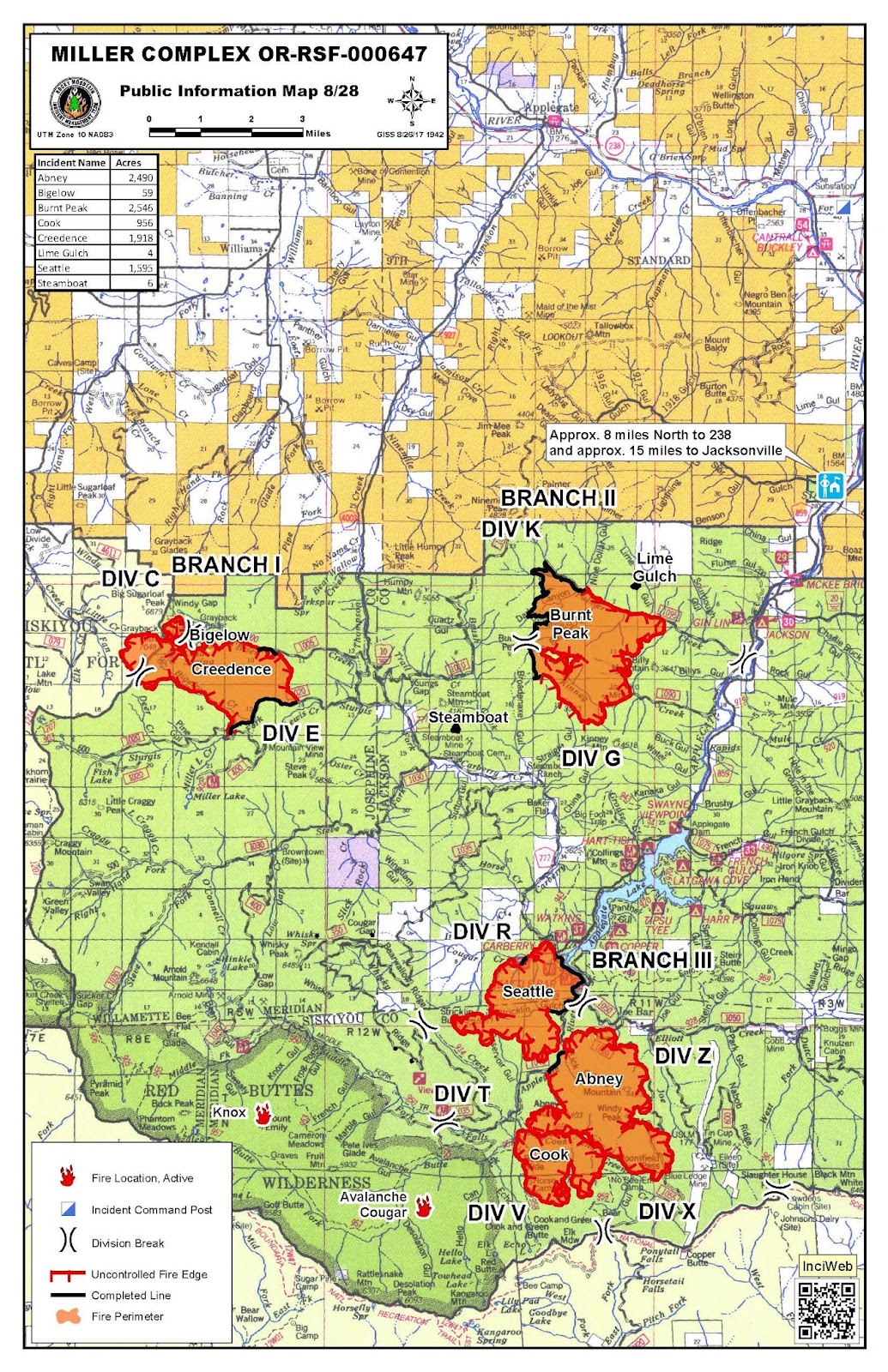
Miller Complex
[Active: Branch I (Creedence, Bigalow); Branch II (Burnt Peak); Branch III (Seattle, Abney, Cook, Knox, Avalanche Cougar). 100% Lined: Steamboat, Lime Gulch; Contained: Border, Foster, Green Valley, Steve Peak, Slick Rock, Bear Wallow, Overview, Whiskey Ridge, Kinney, Lightning Gulch]
Public Meetings: Tuesday, August 29 at 6 p.m. at Applegate Fire District #9, 1095 Upper Applegate Rd. Wednesday, August 30, 6 p.m. at the Williams Elementary School, 20691 Williams Hwy.
Fire Statistics: Start Date: August 14, 2017 Cause: Lightning Complex Size: 10,865 acres Total Personnel: 550 Complex Containment: 48%
Current Situation: The dry weather contributed to an increase in fire behavior, as expected. On Branch I (Creedence, Bigelow) the focus remains on establishing and strengthening control lines by using existing roads. Efforts were greatly assisted by the ability to conduct air operations yesterday, which allowed crews to move critical equipment into the area. On Branch II (Burnt Peak), firefighters are using existing roads to halt the fire’s progression from the north and south by laying hose and digging handline. The fire continues to move down the slope towards the Applegate Road at a very slow pace. Inaccessible terrain helped the Seattle, Cook, and Abney fires on Branch III burn together. They will now be referred to as the Abney Fire. Efforts to protect spreading onto private property continue, especially around the Joe Bar area.
Closures: The Rogue River-Siskiyou National Forest has closed three areas on the Siskiyou Mountains Ranger District including National Forest land between Kinney and Palmer creeks; the Grayback Mountain area; and the areas south of Applegate Lake. Local residents will be allowed to access their property; please bring proof of residence. The Bureau of Land Management has closed the Grayback Mountain Trailhead.
Evacuations: As a precautionary measure, the Level 1 (Be Ready) Evacuation area has been expanded. The following areas are now under a Level 1 Evacuation Notice:
- Palmer Creek Road and Kinney Creek Road (Forest Service Road 1090)
- Both sides of Upper Applegate Road from Palmer Creek Road to the Applegate Dam Spillway (This includes Bolder City)
- Beaver Creek Road
- Carberry Creek Road from Applegate Road up to and including Steamboat Ranch
Joe Bar area, which is in California, is under an evacuation warning. An evacuation warning means that residents should be prepared to evacuate.
DAILY JIC SUMMARY
August 28, 2017
Joint Information Center (JIC) http://swojic.blogspot.com
Overview

Critical fire weather conditions will continue today in Southwest Oregon. Warm, dry and unstable weather patterns are expected to remain this week and humidities may drop into single digits. This means people should expect to see increased fire activity and smoke on most existing fires. It also means a much greater chance for new starts; therefore, the public is asked to be cautious with any activity that could produce a spark. There are numerous area road and trail closures associated with the Chetco Bar, Miller and High Cascades Fires. Recreational users are encouraged to review information available on InciWeb.nwcg.gov about those closures.
It is recommended that people in areas affected by smoke from wildfires decrease their outdoor activity and stay indoors as much as possible. This is especially important for children, older adults, smokers, asthmatics and those with heart or lung diseases. These fires are being suppressed as aggressively as possible; however, expect that smoke will continue to be an issue throughout fire season. Learn more about smoke and air quality here: Smoke Information
Important Notice about Drones: While there has been no reported drone activity over the fires, please remember that drones interfere with firefighting efforts and will ground aircraft needed for fire suppression. The Federal Aviation Administration (FAA) has issued a Temporary Flight Restriction (TFR) over most of the larger fires. Any private aircraft or drone that violates the TFR may face serious criminal charges. Even without a TFR, anyone who hampers firefighting efforts could face criminal charges as well. For more information on drone use, visit the FAA's website www.KnowBeforeYouFly.org. Remember, "If you fly, we can't!"
FIRES AT A GLANCE
FIRE RESOURCES
|
CHETCO BAR
|
MILLER
|
HIGH CASCADES
|
TOTAL RESOURCES
|
Acres
|
117,669
|
9,628
|
18,910
|
146,207
|
Personnel
|
1,551
|
550
|
654
|
2,755
|
Crews
|
34
|
11
|
15
|
60
|
Engines
|
127
|
34
|
23
|
184
|
Dozers
|
19
|
6
|
2
|
27
|
Water Tenders
|
31
|
3
|
6
|
40
|
Helicopters
|
7
|
2
|
8
|
17
|
For more information on what the evacuation levels mean, visit: http://www.rvem.org/general-evacuation-information.html
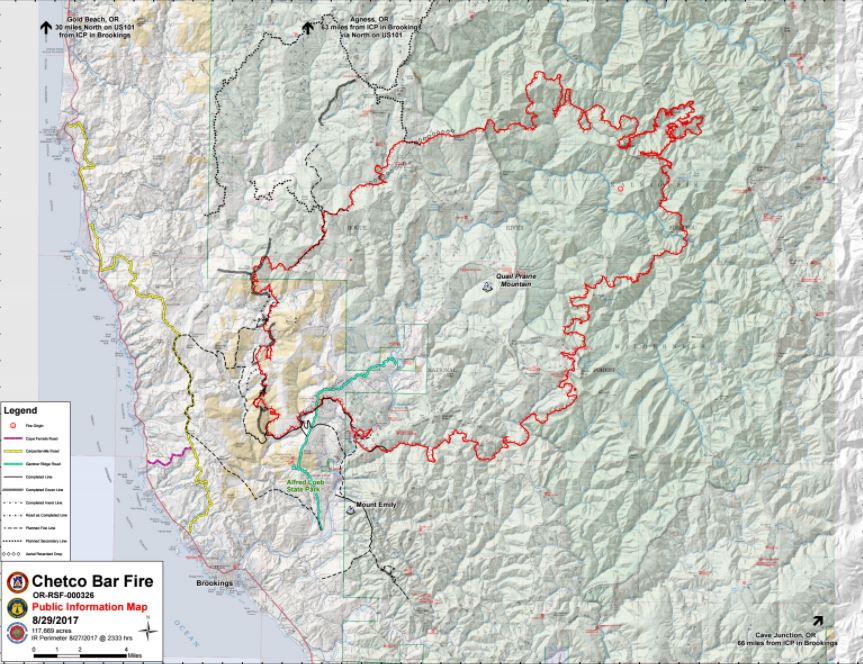
Chetco Bar Fire
Fire Stats:
Start Date: July 12, 2017 Cause: Lightning Acres: 117,669 acres Total Personnel: 1,551
Current Situation:
Firefighters will use an infrared heat-sensing device to locate, then suppress hot spots near the fire’s perimeter. As visibility and weather conditions allow, helicopters and other aircraft will drop retardant and water to help slow the fire’s spread.
Crews will continue to construct direct dozer and handline, install and maintain hose lays and scout for opportunities to extend containment lines north and south of the fire. Planned containment lines incorporate existing roads, sparsely vegetated ridgetops and previously burned areas. A structure protection group will continue to create fuel breaks surrounding homes and maintain hose lays.
Basecamps for Chetco Bar Fire will consolidate into a single location on Oceanview Drive.
Evacuations/Closure Information:
All residences and businesses within the current Level 3 Evacuation zone starting at junction of Shady Lane and South Bank Chetco Road east to, and including, Freeman Rock and Salmon Run Golf Course will be reduced to a Level 2 Evacuation. Residents and businesses will be allowed to return. The area also includes residents in the Campbell and Harbor Hills road area (see attached Level 2 Evacuation map).
All residents that live in this geographic area are asked to present their picture identification to Curry County Sheriff’s Office to receive re-entry materials. Residents can pick up the re-entry materials from 11:00 a.m. to 3:00 p.m. at Ray’s Market, 906 Chetco Ave., Brookings, Oregon, or any of the re-entry points on South Bank Chetco Road.
Residents should remain prepared to evacuate at a moment’s notice in the event the evacuation levels change. It is recommended that residents do not take any large animals home at this time.

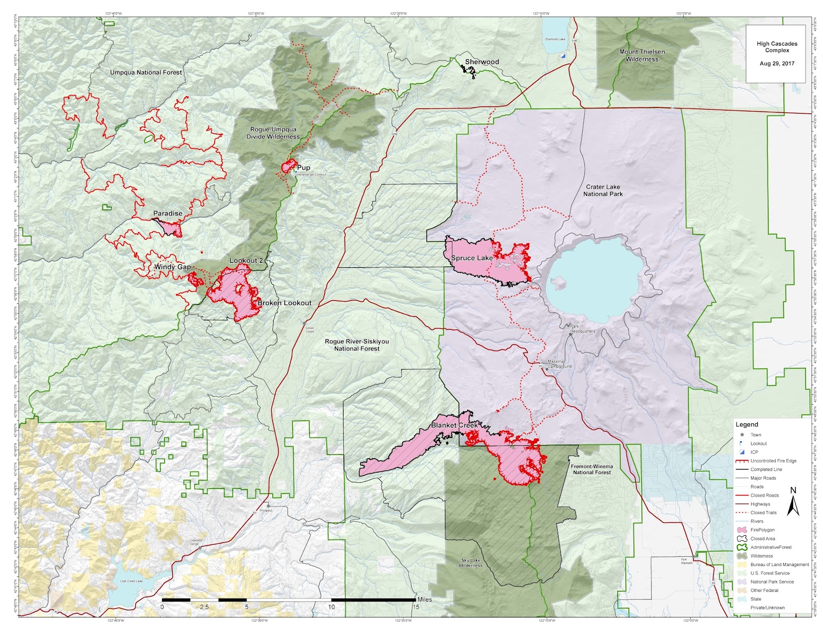
High Cascades Complex
[Active: Broken Lookout, Blanket Creek, Spruce Lake, Pup, Paradise, Lookout 2, Windy Gap. Contained: Sherwood]
Fire Stats:
Cause: Lightning; Sherwood Fire under investigation Complex Size: 18,910 acres Total Personnel: 654 Complex Containment: 44%
Current Situation: Firefighters are actively managing suppression of the High Cascade Complex fires in Crater Lake National Park and the Umpqua, Rogue River-Siskiyou and Fremont-Winema National Forests. Today, flaggers will direct traffic along Hwy. 62 in Crater Lake National Park as crews continue to construct indirect fire lines on the Blanket Creek Fire. Crews will continue line construction around other fires and are monitoring the Spruce Lake Fire. Aircraft will be available to assist ground crew suppression efforts, though helicopters may be diverted to support other fires as needed. Today’s temperatures are expected to be slightly lower than yesterday, but still higher than normal. A drop in humidity is expected to increase fire activity in the afternoon.
Evacuations: Crater Lake National Park issued a Level 1 Evacuation Notification (“Be Ready”) yesterday for Mazama Village due to the Blanket Fire’s continued movement toward Hwy. 62.
Closures: To protect public safety and allow for effective firefighting operations, numerous road, trail and area closures have been issued by the Park and the National Forests. Closure information can be found here: https://inciweb.nwcg.gov/incident/closures/5503/.

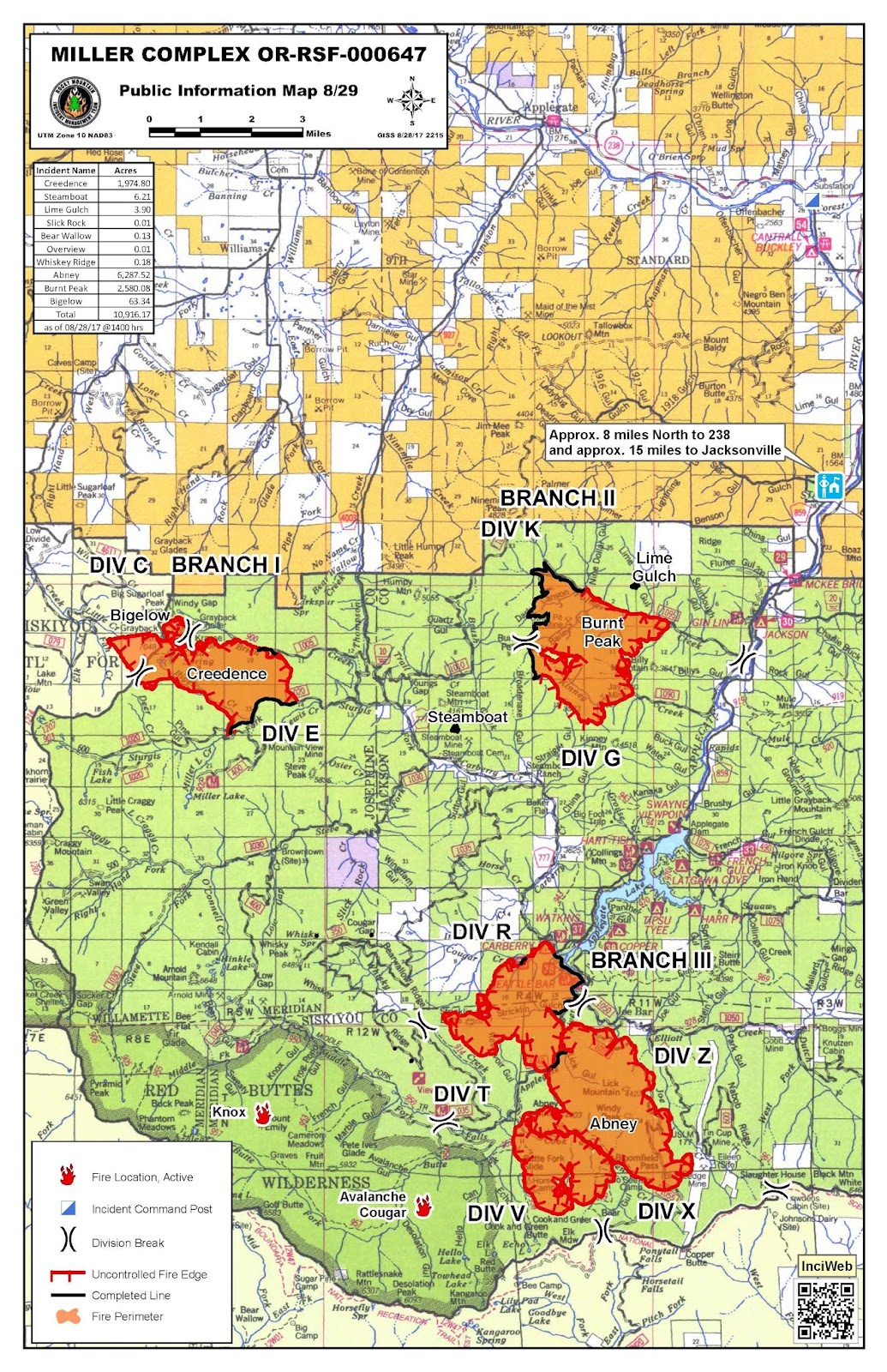
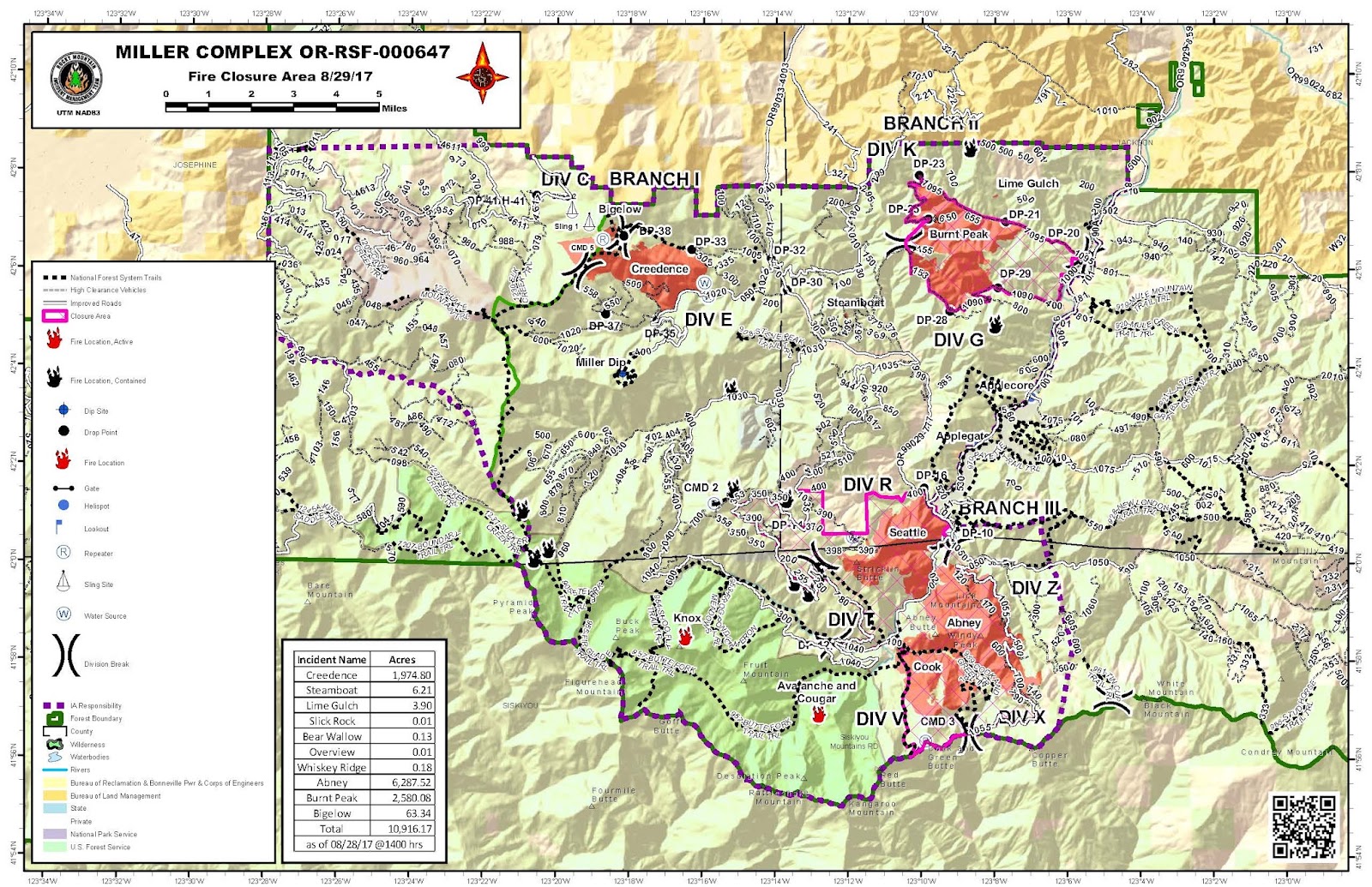
Miller Complex
[Active: Branch I (Creedence, Bigalow); Branch II (Burnt Peak); Branch III (Seattle, Abney, Cook, Knox, Avalanche Cougar). 100% Lined: Steamboat, Lime Gulch; Contained: Border, Foster, Green Valley, Steve Peak, Slick Rock, Bear Wallow, Overview, Whiskey Ridge, Kinney, Lightning Gulch]
Public Meetings: Tuesday, August 29 at 6 p.m. at Applegate Fire District #9, 1095 Upper Applegate Rd. Wednesday, August 30, 6 p.m. at the Williams Elementary School, 20691 Williams Hwy.
Fire Statistics: Start Date: August 14, 2017 Cause: Lightning Complex Size: 9,628 acres Total Personnel: 550 Complex Containment: 48%
Note: A computing error was discovered in acreage calculations. As a result, acreage numbers were adjusted. Map perimeters remain unchanged.
Three firefighters working in the Miller Complex were injured yesterday in a vehicle accident when their engine rolled off the road near the junction of Forest Service Roads 1030 and 1035. One firefighter has serious injuries and two received minor injuries. The families of the three injured firefighters have been notified. The accident is under investigation. No additional information, including the names of the injured firefighters and the nature of their injuries, will be released at this time.
Current Situation: The fires continue to move slowly in most areas, but are still actively burning. The weather will continue to become hotter and drier through mid-week, which is expected to increase fire behavior. There is potential for growth on all fires in the complex, particularly in the late afternoon and evening. Smoke continues to create poor air quality and hamper use of air resources.
Evacuations and Closures: The Rogue River-Siskiyou National Forest has closed three areas on the Siskiyou Mountains Ranger District including National Forest land between Kinney and Palmer creeks; the Grayback Mountain area; and the areas south of Applegate Lake. Local residents will be allowed to access their property; please bring proof of residence. The Bureau of Land Management has closed the Grayback Mountain Trailhead.
As a precautionary measure, Level 1 (Be Ready) Evacuation Notices were issued for the following areas:
- Palmer Creek Road at Upper Applegate Road to the 1090/1095 split
- West of Upper Applegate Road and east of Applegate River from Palmer Creek Road to Jackson Campground (11,000 block)
- Boulder City at 11425 Upper Applegate Road
- Carberry Creek Road at Applegate Road to Steamboat Ranch
- Joe Bar area
A Southwest Oregon Joint Information Center (JIC) has been established in Medford to serve as a ‘one-stop-shopping’ spot to get information on fires and information related to fires currently burning on federal and state lands. Agencies represented at the JIC include the USDA Forest Service, Oregon Department of Forestry, Coos Forest Protective Association, Bureau of Land Management and National Park Service.
DAILY JIC SUMMARY
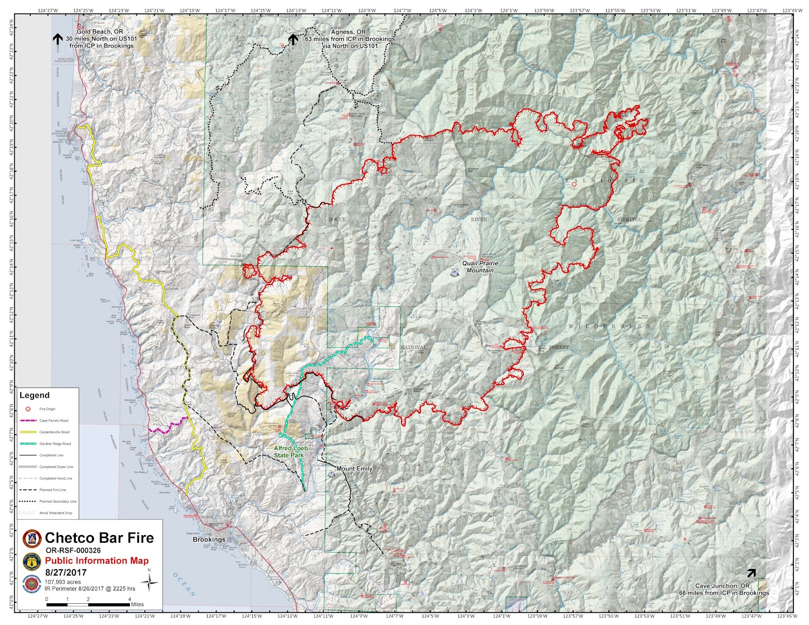
August 27, 2017
Joint Information Center (JIC) http://swojic.blogspot.com
Overview
Since July 25, 2017, federal, state & private lands have been experiencing a high level of fire activity across the landscape. The fires, located near the communities of Prospect (High Cascades Fire), Applegate Valley (Miller Complex) and Brookings (Chetco Bar), have been in full suppression mode since their initial start dates.
Local, county, state and federal agencies continue to work together to face the daily challenges of protecting human life, homes and private property while assisting impacted communities. The Forest Service, Bureau of Land Management, Coos Forest Protective Association, Oregon Department of Forestry and the National Park Service are working collaboratively to suppress these fires.
FIRES AT A GLANCE
FIRE RESOURCES
|
CHETCO BAR
|
MILLER
|
HIGH CASCADES
|
TOTAL RESOURCES
|
Acres
|
107,993
|
14,066
|
16,400
|
138,459
|
Personnel
|
1,662
|
537
|
856
|
3,055
|
Crews
|
42
|
17
|
18
|
77
|
Engines
|
105
|
24
|
28
|
157
|
Dozers
|
26
|
6
|
3
|
35
|
Water Tenders
|
31
|
15
|
21
|
67
|
Helicopters
|
15
|
4
|
8
|
27
|
For more information on what the evacuation levels mean, visit: http://www.rvem.org/general-evacuation-information.html
The Southwest Oregon Joint Information Center (JIC) is an information clearinghouse for large fires including the Chetco Bar Fire, High Cascades Complex and Miller Complex. The JIC will include information on additional large fires as they arise. See swojic.blogspot.com for the latest information.
Chetco Bar Fire
Fire Stats:
Start Date: July 12, 2017 Cause: Lightning Acres: 107,993 acres Total Personnel: 1,662
Current Situation: Crews will continue to strengthen and mop-up containment lines on the southwestern corner of the fire. To the north and south, crews are scouting for and building direct and indirect fireline using existing roads, ridgetops that are sparsely vegetated and previously burned areas. Structure protection efforts continue, focusing on reducing fuels around homes. The structure protection group is also installing hose lays and sprinkler systems.
Evacuations/Closure Information: The Curry County Sheriff’s Office decreased the evacuation level yesterday for many residences in a level 3 evacuation zone starting at Henderson Road and Carpenterville Road, north to Cape Ferrelo Road, and east and west off Carpenterville Road, homeowners will be allowed to return to their homes. More information, including the re-entry process, is available at: https://inciweb.nwcg.gov/incident/article/5385/39102. A map, showing Level I, II and III evacuation areas can be viewed at https://tinyurl.com/ChetcoBarEvac. The Red Cross is operating a shelter at Riley Creek Elementary, 94350 6th St., Gold Beach, Oregon.
High Cascades Complex
[Active: Broken Lookout, Blanket Creek, Spruce Lake, Pup, Paradise, Lookout 2, Windy Gap. 100% Lined: Cougar, Sherwood]
Fire Stats:
Cause: Lightning; Sherwood under investigation Complex Size: 16,400 acres Total Personnel: 856 Complex Containment: 60%
Current Situation: The High Cascades Complex now includes the Paradise, Pup and Windy Gap Fires, formerly associated with the Falcon Complex on the Umpqua National Forest, as well as the Blanket Creek, Spruce Lake, Sherwood and Broken Lookout fires located within Crater Lake National Park and the Rogue River-Siskiyou and Fremont-Winema National Forests. Crews have achieved 100 percent containment of Sherwood Fire and mop-up is complete.
Today’s weather is forecasted to be hot, dry and unstable, with a Red Flag Warning issued for the entire complex. Significant acreage increases are possible at uncontained fire perimeters within the complex. Crews will continue to work around structures in Mazama Village and to prepare Highway 62 in the southeast corner of Crater Lake National Park as a future containment line for Blanket Creek Fire. Helicopters, scooper aircraft and air tankers will be available to assist ground crews, provided smoky conditions do not hinder their use.
Evacuations: Today Crater Lake National Park issued a Level 1 Evacuation Notice for Mazama Village.
Closures: To protect public safety and allow for effective firefighting operations, numerous road, trail and area closures have been issued by the Park and the National Forests. Closure information can be found here: https://inciweb.nwcg.gov/incident/closures/5503/.
Miller Complex
[Active: Branch I (Creedence, Bigalow); Branch II (Burnt Peak); Branch III (Seattle, Abney, Cook, Knox, Avalanche Cougar). 100% Lined: Steamboat, Lime Gulch; Contained: Border, Foster, Green Valley, Steve Peak, Slick Rock, Bear Wallow, Overview, Whiskey Ridge, Kinney, Lightning Gulch]
Public Meetings: Tuesday, August 29 at 6 pm at Applegate Fire District #9 in the training building and Wednesday, August 30 at 6 pm at the Williams Elementary School.
Fire Statistics: Start Date: August 14, 2017 Cause: Lightning Complex Sized: 14,066 acres Total Personnel: 537 Complex Containment: 48%
Current Situation: The fires continue to move slowly in most areas, but are still experiencing some active burning conditions. The weather will continue to become hotter and drier through Monday, which is expected to increase fire behavior. There is potential for growth on all fires in the complex. Smoke continues to create poor air quality and hamper use of air resources.
Evacuations and Closures: The Rogue River-Siskiyou National Forest has closed three areas on the Siskiyou Mountains Ranger District including National Forest land between Kinney and Palmer creeks; the Grayback Mountain area; and the areas south of Applegate Lake. Local residents will be allowed to access their property; please bring proof of residence. The Bureau of Land Management has closed the Grayback Mountain Trailhead.
As a precautionary measure, Level 1 (Be Ready) Evacuation Notices were issued for the following areas:
- Palmer Creek Road at Upper Applegate Road to the 1090/1095 split
- West of Upper Applegate Road and east of Applegate River from Palmer Creek Road to Jackson Campground (11,000 block)
- Boulder City at 11425 Upper Applegate Road
- Carberry Creek Road at Applegate Road to Steamboat Ranch
- Joe Bar area
No comments:
Post a Comment
Note: Only a member of this blog may post a comment.