
Saturday, September 30, 2017
Friday, September 29, 2017
DAILY JOINT INFORMATION CENTER (JIC) SUMMARY
September 29, 2017
swofireinfo@gmail.com
541-608-1243
The Joint Information Center plans to close Saturday, September 30 at 5PM due to the decline in fire behavior and weather changes. Information for each of the three incidents will continue at their specific locations. Details are posted below.
Overview: Warm temperatures yesterday, the hottest for the week, slightly increased fire activity, but no issues were reported. Mop up continues as necessary, and fire crews continue to patrol fire flanks along with suppression line rehabilitation. Cooler and wetter conditions begin to develop today. A Forest-wide list of area closures is available on the RRSNF Fire Information Page.
Fires at a Glance

09-29-17 Chetco Bar Fire Update

|
|

9-29-17 High Cascades Complex West Fire Daily Update
Special Announcements: Smoke from California wildfires has drifted north into the area. Please check the Air Quality websites below for the most up to date information on smoke in your specific location.
The significant rain event previously predicted for the area on Tuesday has been downgraded to where even a wetting rain might not materialize. Forecast models are no longer showing the 1/2 to 1 inch of rain.
Fire Information Center: (541) 316-8352 Available 8:00 am to 9:00 pm.
Information Websites: Inciweb – https://inciweb.nwcg.gov/incident/5503 and Facebook https://www.facebook.com/R6RRSNF and https://facebook.com/UmpquaNationalForest/
Incident Management Team: Northwest Interagency Incident Management Team 8, Incident Commander, Tim Keith, is managing the High Cascades Complex - West Zone. The incident command post (ICP) is located at the Joseph Stewart State Park near Lost Creek Reservoir southwest of Prospect, Oregon. A spike camp is located at Milo Academy near Milo, Oregon.
Current Fire Information: Pup – 8,273 acres, 13% contained. Located northwest and southeast of Hershberger Lookout partially in the Rogue-Umpqua Divide Wilderness. Suppression repairs have been completed on the handline along the south flank. Crews are patrolling and mopping-up hot spots. The north indirect containment line along Forest Road (FR) 2840 has been cleaned up and equipment is repairing any road damage. Merchantable logs are being decked for future use. On the east indirect line along FR 6520, vegetation and slash generated from indirect fire line construction is being hauled by dump trucks to a near-by rock pit for storage and later processing or burning.
Broken Lookout – 19,142 acres, 27% contained. Located directly west of Union Creek on the southern end of the Rogue-Umpqua Divide Wilderness where it is burning on both sides of the Wilderness. On the south flank, firefighters are tightening lines to reduce acres lost and tie in the fire edge , inside of the current indirect containment lines. Firefighters are repairing secondary, unneeded dozer containment lines. Along FR 700 chipping of vegetative debris generated from indirect fire line construction continues. Mopping up is proceeding along the south flank.
Resources: Total personnel assigned to the Complex (both Zones) – 497: 1-type 1 crew, 2-type 2 IA crews, 6-type 2 crews, 6-camp crews, 9-engines, 4-masticators, 2-medium helicopters, 2- light helicopters, 1-dozer, 4-water tenders, and 91 overhead.
Air Operations: A temporary flight restriction (TFR) is in place over the fire area restricting aerial public access. Please check the NOTAMs prior to flying. The public is reminded all air operations are grounded any time a drone is sighted within the TFR, delaying fire suppression efforts. Flying within the TFR is prohibited and against the law. The helibase is located at the Prospect Airport and is closed to public use. The airport is planned to reopen on October 15th.
Air Quality: Pollutants are present at a moderate level due to smoke from fires in California drifting into southern Oregon. For the most up to date air quality reported for your area see Air Now
http://www.airnow.gov/ or the Oregon Smoke Blog http://oregonsmoke.blogspot.com
Weather: Yesterday was the last of the warmer, drier weather for at least the next week. A cold front
moved into the area bringing cooler temperatures, higher relative humidity, and potential for rain
showers. Maximum temperatures are forecasted for 64 degrees and relative humidity 40-60% percent thisafternoon. Ridgetop winds will be southwest turning to northwest and increasing 7-10 mph in the
afternoon.
Behavior: Fine dead fuels moisture continues to be low, however the vast majority of the fire fuels are starting to moiston. The greatest fire behavior potential will be on south facing slopes or under a more open canopy. Smoldering duff could kindle to a low intensity surface fire with minimal ground spread, with correct wind alignment. Creeping and smoldering may re-establish in the litter, duff and jackpots (piles) of dead and down fuels.
Closures: Multiple area, trail, and Forest road closures are limiting public access into specific areas for public safety. “Know before you go” by visiting https://inciweb.nwcg.gov/incident/5503 or your local Forest office. Know: the forecasted weather; road, trail and area closure information; and be aware of firefighters working in the vicinity of your recreational activities.


Miller Complex Fire Update
September 29, 2017 – 9:00 a.m.
Acres: 36,654
Percent Contained: 80%
Start Date: August 14, 2017
Cause: Lightning
Total Personnel: 177
Location: Private land and federal land on the Rogue River-Siskiyou National Forest 20 miles west of Ashland, OR.
Fire Information: 541-838-0770, Email address: millercomplex2017@gmail.com
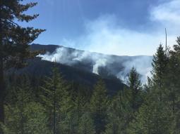
Over the last two days, the Abney Fire grew by about 400 acres. A smoke column was visible yesterday from the Dutch Creek area. Due to steep slopes, poor access, and heavy fuel loading ground crews were not committed to build direct containment lines. A heavy helicopter dropped water buckets throughout the shift to slow fire growth. Overall, fire managers view this as a beneficial piece of natural fire that burned as they expected well within established containment lines.
Cooler weather is forecasted through the weekend, bringing lower temperatures and higher humidity that should lead to a decrease in fire activity. Light to moderate rain is expected over the fire area Friday morning through afternoon, although wetting rain is unlikely. Moderate winds out of the north will be the main concern through Friday evening and could promote some fire growth. Firefighters and heavy helicopters are available to take action as needed.
Crews continue to monitor and patrol hand lines on the Burnt Peak and Creedence fires. Repair work, including brushing and chipping of roads, continues across the complex in order to naturalize areas impacted by fire suppression tactics.
Closures: An area closure remains in place for the Miller Complex. Roads bordering the Burnt Creek and Creedence fires remain closed. Although Carberry Creek Road has been opened, spur roads leading to the burn area also remain closed. Forest officials and fire managers ask that individuals adhere to the area closure still in effect for public and firefighter safety. Forest visitors are cautioned to remain alert and drive with care when near fire areas as crews will still be working in these zones.
For more information on the area closure visit the Rogue River-Siskiyou National Forest closure page at https://www.fs.usda.gov/alerts/rogue-siskiyou/alerts-notices.
The Bureau of Land Management has closed the Grayback Mountain Trailhead. For Klamath National Forest closures see https://www.fs.usda.gov/alerts/klamath/alerts-notices.
Miller Complex Information Websites:
Inciweb - https://inciweb.nwcg.gov/incident/5514/
Miller Complex Abney Fire, south of the Pacific Crest Trail (PCT) - https://inciweb.nwcg.gov/incident/5511/
ODFW Web Information about hunting and closures- https://www.dfw.state.or.us/resources/hunting/fire.asp
For all wildfires on the Rogue River-Siskiyou NF, Joint Information Center Blog - http://swojic.blogspot.com/

Infrared Map of Abney Fire

Total Miller Complex Map
Thursday, September 28, 2017
DAILY JOINT INFORMATION CENTER (JIC) SUMMARY
September 28, 2017
541-608-1243
Overview: Yesterday's higher temperatures and lower humidity increased fire activity mostly on the Abney Fire, within the Miller Complex. All the other fires did not see an increase in fire behavior. Fire fighters continue to patrol fire flanks and work continues with suppression line rehabilitation. Starting Friday, cooler and wetter conditions begin to develop.

Light smoke from the Miller Complex yesterday; Firefighters working in a riparian area along a previously built fire line on the High Cascade Complex
Fires at a Glance
FIRE RESOURCES
|
CHETCO BAR
|
MILLER
|
HIGH CASCADES
|
TOTAL RESOURCES
|
Acres
|
191,088
|
36,496
|
80,152
|
307,736
|
% Contained
|
97
|
80
|
32
|
N/A
|
Personnel
|
541
|
187
|
604
|
1332
|
Crews
|
7
|
4
|
12
|
23
|
Engines
|
14
|
10
|
14
|
38
|
Dozers
|
3
|
2
|
1
|
6
|
Water Tenders
|
5
|
5
|
1
|
11
|
Helicopters
|
7
|
2
|
5
|
14
|
 Miller Complex Fire Update
September 28, 2017 – 9:00 a.m.
Today will bring more warm and dry weather over the fire and a visible smoke column is expected in the area as fire activity increases in response to these trends. Crews are engaged along the active portions and are providing real time observations on fire behavior and progression. The fire is well within designated containment lines that include road systems and natural barriers.
Today will likely be the last day of active burning as a cold front will arrive tomorrow and bring more fall-like weather over the weekend. Some light rain is expected on Friday but wetting rain is unlikely.
The Creedence and Burnt Peak fires are each at 95% containment and repair work continues on hand and dozer lines no longer in use. Overall containment on the Miller Complex has increased to 80% and will likely remain there until a season ending weather event.
Closures: An area closure remains in place for the Miller Complex. Roads bordering the Burnt Creek and Creedence fires remain closed. Although Carberry Creek Road has been opened, spur roads leading to the burn area also remain closed.
Forest officials and fire managers ask that individuals adhere to the area closure still in effect for public and firefighter safety. Forest visitors are cautioned to remain alert and drive with care when near fire areas as crews will still be working in these zones. For more information on the area closure visit the Rogue River-Siskiyou National Forest closure page at https://www.fs.usda.gov/alerts/rogue-siskiyou/alerts-notices.
The Bureau of Land Management has closed the Grayback Mountain Trailhead. For Klamath National Forest closures see https://www.fs.usda.gov/alerts/klamath/alerts-notices.
Miller Complex Information Websites:
Inciweb - https://inciweb.nwcg.gov/incident/5514/
Miller Complex Abney Fire, south of the Pacific Crest Trail (PCT) - https://inciweb.nwcg.gov/incident/5511/
ODFW Web Information about hunting and closures- https://www.dfw.state.or.us/resources/hunting/fire.asp
For all wildfires on the Rogue River-Siskiyou NF, Joint Information Center Blog -http://swojic.blogspot.com/

09-28-17 Chetco Bar Fire Update
Community Meeting There will be a public meeting, hosted by the Rogue River-Siskiyou National Forest, providing history of the fire, at the Brookings Harbor High School (525 Pioneer Road, Brookings, OR) today at 6:00 p.m.
Today Aircraft equipped with heat-sensing capability flew over the fire area Wednesday to capture the locations of any remaining heat. Crews will continue to patrol and monitor these areas of the fire, seeking hotspots and mopping-up. Firefighters work to repair suppression lines by clearing brush, chipping and road grading. This is necessary to repair damage and disturbance caused by the fire suppression actions taken. No visible smoke was seen on the Indigo fire yesterday. Repair work on the roads near the Indigo fire is completed.
On Thursday morning, the Chetco Bar Fire transitioned from unified command to a single command structure under leadership of Chris Schulte, Pacific Northwest Team 2 – National Incident Management Team. Under unified command, Tom Savage served as Incident Commander for Coos Forest Protective Association. His contribution to the incident, association members and area forestry has been tremendous. Agency representatives from the Forest Service, Bureau of Land Management and Coos Forest Protective Association will continue to be integrally involved in planning and implementation of suppression and repair activities – providing leadership for the land and resources specific to their organizational units.
Closures and Safety Rogue River-Siskiyou National Forest and Bureau of Land Management Coos Bay District road and area closures remain in effect for all public lands adjacent to the Chetco Bar Fire area due to residual fire activity, heavy equipment in transit, and hazards presented by fire-weakened trees.
Managers are assessing progress by firefighters, conditions on the ground, and other factors in order to reduce the scope of closures. Patience is requested and appreciated. For public and firefighter safety, please adhere to closures, whether staffed with road guards or unstaffed. For further information, please call (541) 618-2200 or visit www.fs.usda.gov/alerts/rogue-siskiyou/alerts-notices.
Weather and Fire Behavior Partly cloudy until noon, then sunny, ranging from 75-80 degrees. A cold front will arrive at the coast early Friday and then move onshore during the day. Expect minor smoldering activity and few smokes. Open flame remains unlikely.
Temporary Flight Restrictions (TFR) are in effect over the Chetco Bar Fire area. Before flying near the area, pilots are encouraged to check for the most current update at tfr.faa.gov.


9-28-17 High Cascades Complex West Fire Daily Update
Fire Information Center: (541) 316-8352 Available 8:00 am to 9:00 pm.
Information Websites: Inciweb – https://inciweb.nwcg.gov/incident/5503 and Facebook https://www.facebook.com/R6RRSNF and https://facebook.com/UmpquaNationalForest/
Current Fire Information: The High Cascades Complex - West Zone is a compilation of fires started by lightning storms earlier this summer. The West Zone consists of the Pup and the Broken Lookout Fires. Both fires are partially burning in and outside of the Rogue-Umpqua Divide Wilderness on the Rogue River-Siskiyou and Umpqua National Forests. Firefighters are making significant progress with suppression and vegetation clean-up on all divisions. The information from a nighttime infra-red, heat detecting flight displayed fire perimeter locations therefore the acreages where slightly increased.
Pup – 8,273 acres, 13% contained. Located northwest and southeast of Hershberger Lookout partially in the Rogue-Umpqua Divide Wilderness. Suppression repairs have been completed on the handline along the south flank. Crews are patrolling and mopping-up hot spots. The north indirect containment line clean-up has been completed and equipment is repairing any road damage. Hauling of piled vegetation generated from indirect fire line constructed along forest roads is progressing along the east indirect containment lines.
Broken Lookout – 19,142 acres, 27% contained. Located directly west of Union Creek on the southern end of the Rogue-Umpqua Divide Wilderness where it is burning on both sides of the Wilderness. Firefighters are assessing repairs needed on the south, southwest, and west indirect containment lines. Firefighters are chipping vegetative debris generated from indirect fire line construction along forest roads and patrolling for hotspots. Mopping up is proceeding along the south flank.
Resources: Total personnel assigned to the Complex (both Zones) – 604: 2-type 1 crews, 2-type 2 IA crews, 8-type 2 crews, 6-camp crews, 13-engines, 4-masticators, 3-medium helicopters, 2- light helicopters, 1-dozer, 5-water tenders, and 253 overhead.
Air Operations: A temporary flight restriction (TFR) is in place over the fire area restricting aerial public access. Please check the NOTAMs prior to flying. The public is reminded all air operations are grounded any time a drone is sighted within the TFR, delaying fire suppression efforts. Flying within the TFR is prohibited and against the law. The helibase is located at the Prospect Airport and is closed to public use. The airport is planned to reopen on October 15th.
Air Quality: For the most up to date air quality reported for your area see Air Now http://www.airnow.gov/ or the Oregon Smoke Blog http://oregonsmoke.blogspot.com
Weather: Warmer and drier conditions are expected again today under sunny skies with southeast ridgetop winds in the morning. Becoming terrain driven in the afternoon. Temperatures, 79 to 84 degrees and relative humidity, 20 – 35% percent this afternoon. Ridgetop winds will be southeast 6 – 9 mph. Friday through Monday a cold front is expected to pass with wetting rain possible Friday and significant rainfall by Tuesday.
Behavior: Fine dead fuels moistures will be low today, however the vast majority of the fires are still moist to wet. The greatest fire behavior potential will be on south facing slopes or under a more open canopy. Smoldering duff may kindle to a low intensity surface fire with minimal ground spread. Creeping and smoldering may re-establish in the litter, duff and jackpots (piles) of dead and down fuels.
Closures: Multiple area, trail, and Forest road closures are limiting public access into specific areas for public safety. “Know before you go” by visiting https://inciweb.nwcg.gov/incident/5503 or your local Forest office. Know: the forecasted weather; road, trail and area closure information; and be aware of firefighters working in the vicinity of your recreational activities.

Wednesday, September 27, 2017

DAILY JOINT INFORMATION CENTER (JIC) SUMMARY
September 27, 2017
541-608-1243
Overview: Fire behavior analysts do not anticipate significant fire activity to return on any fires as temperatures rise and humidity drops over the next two days. Increased smokes from logs and stump holes will likely occur. Fire fighters continue to patrol fire flanks and work continues with suppression line rehabilitation and equipment back hauling. The public is asked to comply with Forest closure areas to ensure their and firefighter safety.

Crews chipping vegetation from containment lines at High Cascade Complex; Fire fighter working on fire suppression line rehabilitation on Miller Complex
Fires at a Glance

Miller Complex Fire Update
September 27, 2017 – 9:00 a.m.
Acres: 36,496
Percent Contained: 75%
Start Date: August 14, 2017
Cause: Lightning
Total Personnel: 193
Location: Private land and federal land on the Rogue River-Siskiyou National Forest 20 miles west of Ashland, OR.
Fire Information: 541-838-0770, Email address: millercomplex2017@gmail.com
Over the next few days the Abney Fire will continue to respond to warming and drying trends as a thermal trough moves over the area. Warmer temperatures are drying fuels out, producing additional smoke from the incident. Firefighters are not able to access the steep, rough terrain on the east flank of the fire.
Isolated areas continue to burn, funneling smoke down Elliot Creek and West Fork of Dutch Creek. A morning inversion then traps the smoke, not allowing it to rise. This process is occurring between the hours of 8:00 a.m. to 12:00 p.m. and by midday the ground is heating up enough to cause the smoke to lift out of the inversion and disperse. With higher temperatures and lower humidity recoveries at night, the inversion is expected to last a few more days until predicted weather patterns change over the weekend.
Fire crews continue to monitor and patrol the Creedence and Burnt Creek fires, with a focus on repair work and removal of equipment, pumps, and hoses. Containment lines no longer in use have been reseeded with native flora, in coordination with district botanists and resource advisors. Crews on the Abney Fire are also focusing on road improvement work and pulling back berms on hand lines and dozer lines. Fire managers do expect an increase in fire behavior on the east flank of the Abney Fire, with geographic features and road systems serving as containment lines.
Closures: The Miller Complex area closure has been reduced. Roads bordering the Burnt Creek and Creedence fires remain closed. Although Carberry Creek Road has been opened, spur roads leading to the burn area also remain closed. Forest officials and fire managers ask that individuals adhere to the area closure still in effect for public and firefighter safety. Forest visitors are cautioned to remain alert and drive with care when near fire areas as crews will still be working in these zones. For a more precise, technical definition of these closures, please see Forest Order Number 06-10-22-17-37, or visit the Rogue River-Siskiyou National Forest closure page at https://www.fs.usda.gov/alerts/rogue-siskiyou/alerts-notices. The Bureau of Land Management has closed the Grayback Mountain Trailhead. For Klamath National Forest closures see https://www.fs.usda.gov/alerts/klamath/alerts-notices.
Miller Complex Information Websites:
Inciweb - https://inciweb.nwcg.gov/incident/5514/
Facebook - https://www.facebook.com/MillerComplexFires/ and https://facebook/R6RRSNF
Miller Complex Abney Fire, south of the Pacific Crest Trail (PCT) - https://inciweb.nwcg.gov/incident/5511/
ODFW Web Information about hunting and closures- https://www.dfw.state.or.us/resources/hunting/fire.asp
For all wildfires on the Rogue River-Siskiyou NF, Joint Information Center Blog - http://swojic.blogspot.com/

Firefighter performing suppression repair work
Posted on: 09/26/17 10:49 am

Infrared Map
Subscribe to:
Posts (Atom)