
Joint Information Center (JIC) http://swojic.blogspot.com
OVERVIEW
Weather today remains much like yesterday with hot temperatures and low humidity throughout southern Oregon. Both nationally and regionally we remain at the highest preparedness level, which means that there are numerous large fires burning throughout several geographic areas in the U.S. and that weather conditions are such that additional fires are likely. This results in increased competition for crews, aircraft, engines and other firefighting resources.
Despite these challenging conditions, firefighters and fire equipment are being reassigned, as needed, between the three large fires on the Rogue River-Siskiyou National Forest.
There are numerous area road and trail closures associated with the Chetco Bar, Miller and High Cascades Fires. Fire restrictions are also in place for private, industrial, BLM and National Forestland. For the latest restrictions visit: http://tinyurl.com/FireLinks2017.
Smoke conditions will continue to be deemed ‘unhealthy’ throughout most of southern Oregon. Drift smoke and haze that you are experiencing may be coming from fires that are miles away from your location which tends to settle in low-lying areas. Local health officials have provided the following smoke precautions:
- Stay indoors as much as possible.
- Avoid outdoor exercise.
- Keep windows and doors closed.
- Keep indoor air clean.
- Drink plenty of fluids.
To learn more about smoke and air quality, check out: Smoke Information
FIRES AT A GLANCE
FIRE RESOURCES
|
CHETCO BAR
|
MILLER
|
HIGH CASCADES
|
TOTAL RESOURCES
|
Acres
|
125,271
|
12,469
|
21,432
|
159172,
|
Personnel
|
1,498
|
550
|
610
|
2,658
|
Crews
|
38
|
11
|
18
|
67
|
Engines
|
114
|
34
|
22
|
170
|
Dozers
|
19
|
6
|
2
|
27
|
Water Tenders
|
25
|
3
|
12
|
40
|
Helicopters
|
8
|
1
|
7
|
16
|
For more information on what the evacuation levels mean, visit: http://www.rvem.org/general-evacuation-information.html
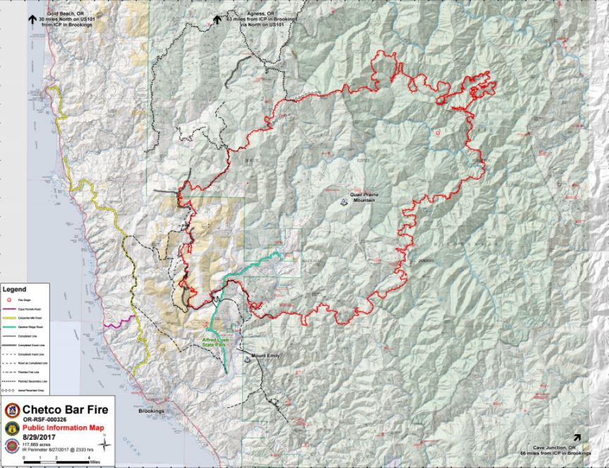
Chetco Bar Fire
Fire Stats:
Start Date: July 12, 2017 Cause: Lightning Acres: 125,271 acres Total Personnel: 1,498
Current Situation:
Fire personnel reported 5 percent containment on the Chetco Bar Fire’s west edge today. Crews will continue scouting and constructing primary and alternate containment lines, as well as setting up hose-lays and water sources to be used in securing those lines. Constructed fireline includes a mix of line directly along the edge of the fire and some that is further from the fire’s edge in strategic locations.
The risk to the Brookings area has diminished enough that larger structural engines are no longer needed. Chetco Bar Fire's Unified Command continues to utilize structural task forces that have the smaller engines. Our mission to protect the community and surrounding area remains the same.
120 National Guard firefighters are coming to assist with mop up operations on the fire’s western perimeter.
120 National Guard firefighters are coming to assist with mop up operations on the fire’s western perimeter.
Humidity levels are expected to begin climbing this afternoon. Ridgetop temperatures could reach the 90s. Fire burning in the tops of single trees and groups of trees is anticipated, with the potential for embers to fly up to 0.4 miles ahead of the fire. There is a high potential for large fire growth in areas where wind and terrain align.
Evacuations/Closure Information:
Residences within parts of the Level 3 evacuation zone starting at the junction of Shady Lane and South Bank Chetco Road east, and including Freeman Rock and Salmon Run Golf Course, have been reduced to a Level 2 Evacuation.
Residents should remain prepared to evacuate at a moment’s notice in the event the evacuation levels change. It is recommended that residents do not take any large animals home at this time.
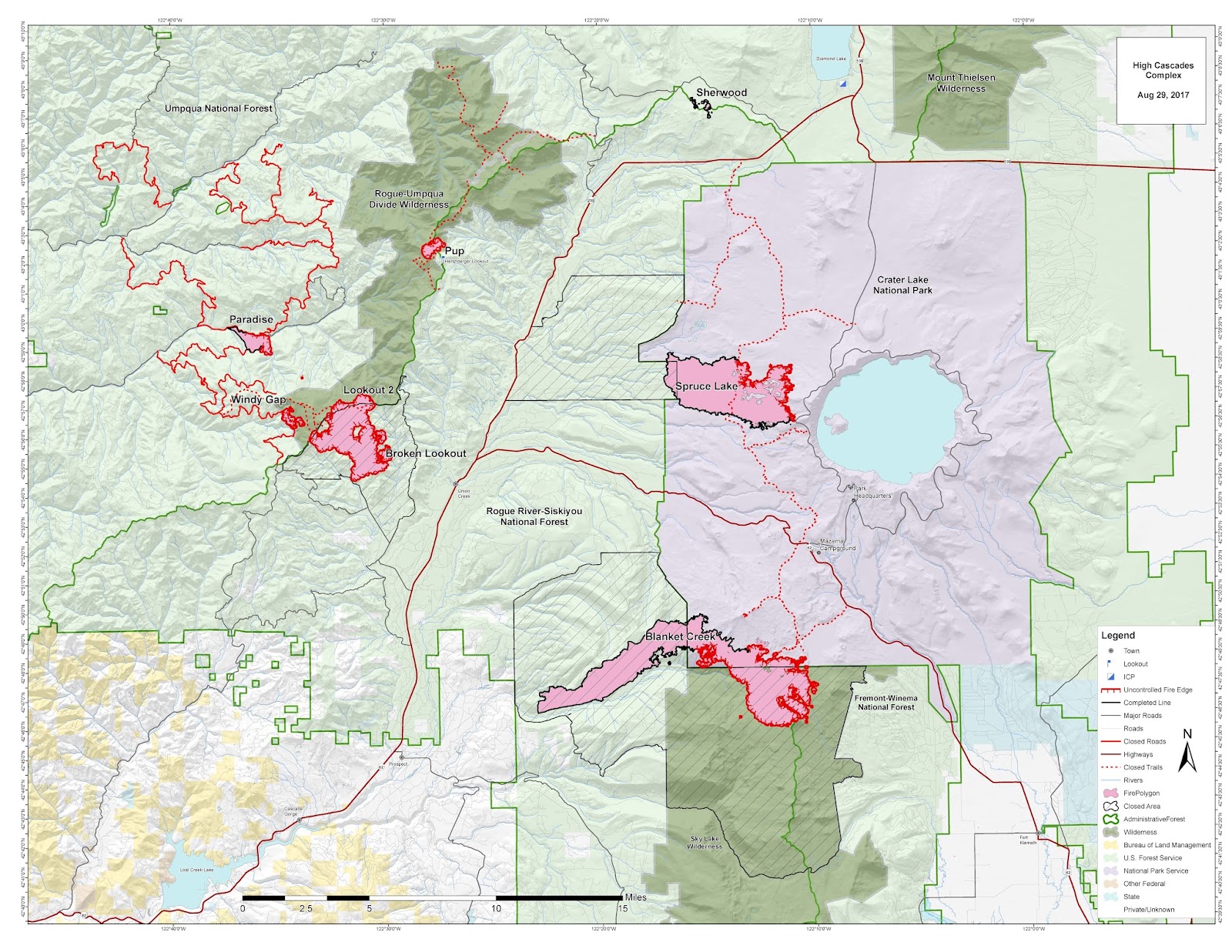
High Cascades Complex
[Active: Branch I (Blanket Creek, Spruce Lake); Branch II (Broken Lookout, Lookout 2, Pup, Paradise, Windy Gap.]
Fire Stats:
Cause: Lightning; Sherwood Fire under investigation Complex Size: 21,432 acres Total Personnel: 610 Complex Containment: 38%
Current Situation: Crews today will be prepping indirect fire lines on the Blanket Creek Fire by clearing along hiking trails northeast of the fire and Highway 62. Firefighters will continue building indirect line along Forest Road 68 near the Broken Lookout and Windy Gap Fires. If smoke conditions allow, aircraft can be used to check fire progression. Yesterday, the High Cascades Complex experienced about 2,500 acres of fire growth, with the Blanket Creek and Broken Lookout Fires contributing roughly 2,000 acres of this growth. Weather will be warm and dry today with persistent smoke expected again over the Complex. Because of high temperatures, low relative humidity and some atmospheric instability, active fire behavior is expected. Visitors may anticipate delays related to fire activity on Highway 62 east of Mazama Village on the road to Fort Klamath, as well as Highway 230 between Union Creek and the Highway 138 junction due to road construction. Please watch for firefighters working along these roads.
Evacuations: Mazama Village in Crater Lake National Park remains at a Level 1 Evacuation Notification (“Be Ready”).
Closures: A number of road, trail and area closures remain in effect in Crater Lake National Park and the Rogue River-Siskiyou, Umpqua and Fremont-Winema National Forests. Although there are trail closures related to fire activity in the Park, Crater Lake National Park is open. The Park’s West Rim Drive is closed from Sunday night to Friday afternoon because of construction, not fire activity. Closure information can be found here: https://inciweb.nwcg.gov/incident/closures/5503/.
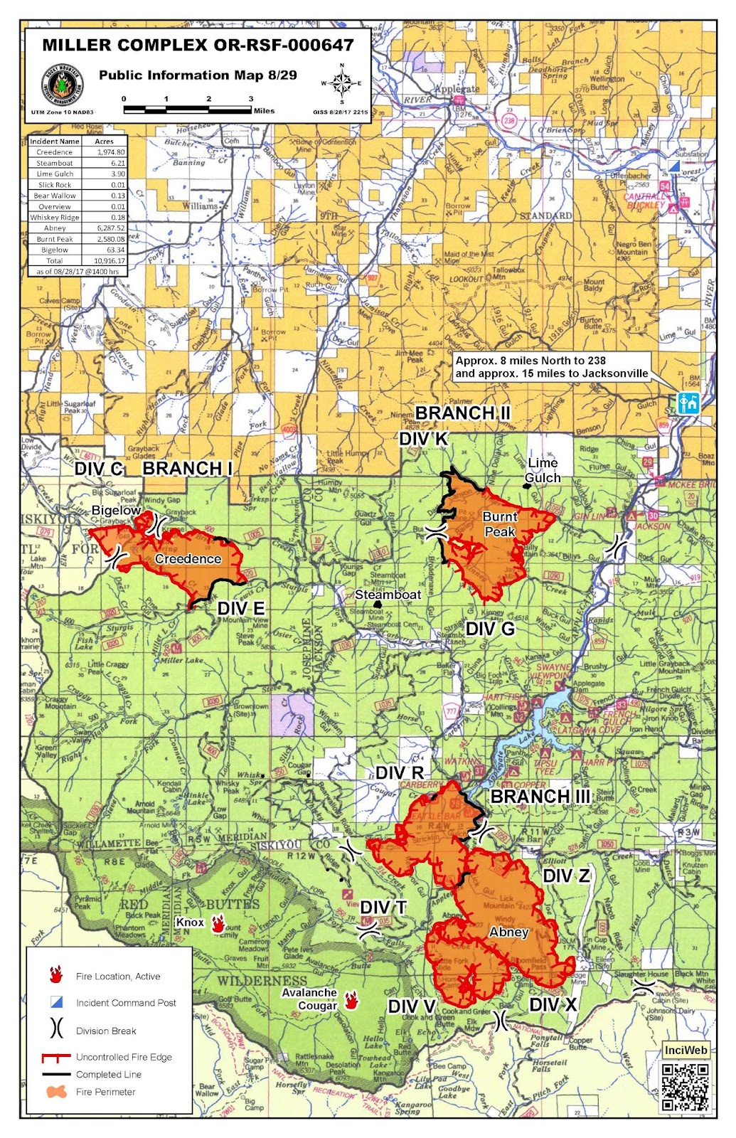
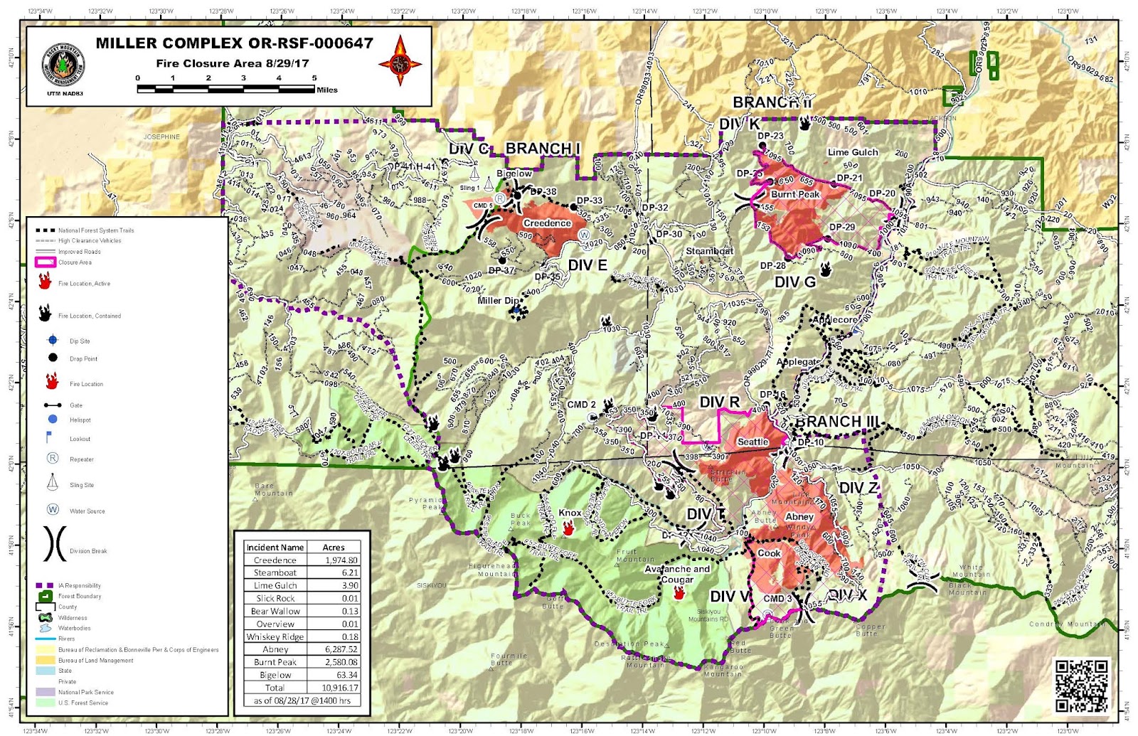
Miller Complex
[Active: Branch I (Creedence, Bigalow); Branch II (Burnt Peak); Branch III (Seattle, Abney, Cook, Knox, Avalanche Cougar). 100% Lined: Steamboat, Lime Gulch; Contained: Border, Foster, Green Valley, Steve Peak, Slick Rock, Bear Wallow, Overview, Whiskey Ridge, Kinney, Lightning Gulch]
Public Meetings: Tuesday, August 29 at 6 p.m. at Applegate Fire District #9, 1095 Upper Applegate Rd. Wednesday, August 30, 6 p.m. at the Williams Elementary School, 20691 Williams Hwy.
Fire Statistics: Start Date: August 14, 2017 Cause: Lightning Complex Size: 10,865 acres Total Personnel: 550 Complex Containment: 48%
Current Situation: The dry weather contributed to an increase in fire behavior, as expected. On Branch I (Creedence, Bigelow) the focus remains on establishing and strengthening control lines by using existing roads. Efforts were greatly assisted by the ability to conduct air operations yesterday, which allowed crews to move critical equipment into the area. On Branch II (Burnt Peak), firefighters are using existing roads to halt the fire’s progression from the north and south by laying hose and digging handline. The fire continues to move down the slope towards the Applegate Road at a very slow pace. Inaccessible terrain helped the Seattle, Cook, and Abney fires on Branch III burn together. They will now be referred to as the Abney Fire. Efforts to protect spreading onto private property continue, especially around the Joe Bar area.
Closures: The Rogue River-Siskiyou National Forest has closed three areas on the Siskiyou Mountains Ranger District including National Forest land between Kinney and Palmer creeks; the Grayback Mountain area; and the areas south of Applegate Lake. Local residents will be allowed to access their property; please bring proof of residence. The Bureau of Land Management has closed the Grayback Mountain Trailhead.
Evacuations: As a precautionary measure, the Level 1 (Be Ready) Evacuation area has been expanded. The following areas are now under a Level 1 Evacuation Notice:
- Palmer Creek Road and Kinney Creek Road (Forest Service Road 1090)
- Both sides of Upper Applegate Road from Palmer Creek Road to the Applegate Dam Spillway (This includes Bolder City)
- Beaver Creek Road
- Carberry Creek Road from Applegate Road up to and including Steamboat Ranch
Joe Bar area, which is in California, is under an evacuation warning. An evacuation warning means that residents should be prepared to evacuate.
A Southwest Oregon Joint Information Center (JIC) has been established in Medford to serve as a ‘one-stop-shopping’ spot to get information on fires and information related to fires currently burning on federal and state lands. Agencies represented at the JIC include the USDA Forest Service, Oregon Department of Forestry, Coos Forest Protective Association, Bureau of Land Management and National Park Service.
No comments:
Post a Comment
Note: Only a member of this blog may post a comment.