09-29-17 Chetco Bar Fire Update
|
|


09-28-17 Chetco Bar Fire Update
Community Meeting There will be a public meeting, hosted by the Rogue River-Siskiyou National Forest, providing history of the fire, at the Brookings Harbor High School (525 Pioneer Road, Brookings, OR) today at 6:00 p.m.
Today Aircraft equipped with heat-sensing capability flew over the fire area Wednesday to capture the locations of any remaining heat. Crews will continue to patrol and monitor these areas of the fire, seeking hotspots and mopping-up. Firefighters work to repair suppression lines by clearing brush, chipping and road grading. This is necessary to repair damage and disturbance caused by the fire suppression actions taken. No visible smoke was seen on the Indigo fire yesterday. Repair work on the roads near the Indigo fire is completed.
On Thursday morning, the Chetco Bar Fire transitioned from unified command to a single command structure under leadership of Chris Schulte, Pacific Northwest Team 2 – National Incident Management Team. Under unified command, Tom Savage served as Incident Commander for Coos Forest Protective Association. His contribution to the incident, association members and area forestry has been tremendous. Agency representatives from the Forest Service, Bureau of Land Management and Coos Forest Protective Association will continue to be integrally involved in planning and implementation of suppression and repair activities – providing leadership for the land and resources specific to their organizational units.
Closures and Safety Rogue River-Siskiyou National Forest and Bureau of Land Management Coos Bay District road and area closures remain in effect for all public lands adjacent to the Chetco Bar Fire area due to residual fire activity, heavy equipment in transit, and hazards presented by fire-weakened trees.
Managers are assessing progress by firefighters, conditions on the ground, and other factors in order to reduce the scope of closures. Patience is requested and appreciated. For public and firefighter safety, please adhere to closures, whether staffed with road guards or unstaffed. For further information, please call (541) 618-2200 or visit www.fs.usda.gov/alerts/rogue-siskiyou/alerts-notices.
Weather and Fire Behavior Partly cloudy until noon, then sunny, ranging from 75-80 degrees. A cold front will arrive at the coast early Friday and then move onshore during the day. Expect minor smoldering activity and few smokes. Open flame remains unlikely.
Temporary Flight Restrictions (TFR) are in effect over the Chetco Bar Fire area. Before flying near the area, pilots are encouraged to check for the most current update at tfr.faa.gov.

09-27-17 Chetco Bar Fire Update
Today Along the perimeter and interior of the Chetco Bar Fire, firefighters are continuing to patrol, monitor, and mop-up hotspots and extinguishing remaining heat. Warmer and drier weather today and tomorrow will aid suppression efforts by increasing visibility of hotspots, helping crews to locate and extinguish these smokes. Crews will continue to repair hand and dozer lines, inserting waterbars to minimize erosion potential.
In a reconnaissance flight yesterday, the Indigo Fire showed no heat and areas of repair work continue along the indirect lines.
Firefighters, equipment, and support personnel continue to be released as incident objectives are achieved.
Closures and Safety Rogue River-Siskiyou National Forest and Bureau of Land Management Coos Bay District road and area closures remain in effect for all public lands adjacent to the Chetco Bar Fire area due to residual fire activity, heavy equipment in transit, and hazards presented by fire-weakened trees.
Managers are assessing progress by firefighters, conditions on the ground, and other factors in order to reduce the scope of closures. Patience is requested and appreciated. For public and firefighter safety, please adhere to closures, whether staffed with road guards or unstaffed. For further information, please call (541) 618-2200 or visit www.fs.usda.gov/alerts/rogue-siskiyou/alerts-notices.
Weather and Fire Behavior Expect sunny skies with temperatures of 75-85 degrees, similar conditions Thursday, with a cold front approaching by Friday. Minimal fire activity will include a few visible smokes and isolated and creeping hotspots. The continued warm weather will support firefighting efforts by making areas of heat easier to identify and extinguish.
Temporary Flight Restrictions (TFR) are in effect over the Chetco Bar Fire area. Before flying near the area, pilots are encouraged to check for the most current update at tfr.faa.gov.
Community Meeting There will be a public meeting, hosted by the Rogue River-Siskiyou National Forest Service, including a fire history and update, at the Brookings Harbor High School (525 Pioneer Road, Brookings, OR) on Thursday, September 28, at 6:00 p.m.

09-26-17 Chetco Bar Fire Update
Community Meeting: There will be a public meeting, including a fire overview and update, at the Winchuck Volunteer Fire Station (363 Winchuck River Road, Brookings, OR) today at 6:00 p.m.
Today Infrared mapping has confirmed fire fighters’ observations on the Chetco Bar and Indigo fires. Pockets of heat remain, displayed as isolated smokes within the fire interior and in difficult to access areas in the Meadow Creek, East Fork Pistol River, Emily Creek, and Illinois River drainages. Firefighters are mopping up and patrolling these areas.
Firefighters continue to recover unneeded equipment and repair fire lines that are no longer required. Inserting waterbars along hand line and dozer line minimizes erosion potential. Crews place earthen berms, boulders, logs, slash and other vegetative material to obscure previously disturbed areas. In other instances, berms are removed to allow for waterflow and settling of topsoil for vegetative recovery.
Firefighters and support functions continue to be released as incident objectives are achieved.
Closures and Safety Rogue River-Siskiyou National Forest and Bureau of Land Management Coos Bay District road and area closures remain in effect for all public lands adjacent to the Chetco Bar Fire area due to residual fire activity, heavy equipment in transit, and hazards presented by fire-weakened trees.
Managers are assessing progress by firefighters, conditions on the ground, and other factors in order to reduce the scope of closures. Patience is requested and appreciated. For public and firefighter safety, please adhere to closures, whether staffed with road guards or unstaffed. For further information, please call (541) 618-2200 or visit www.fs.usda.gov/alerts/rogue-siskiyou/alerts-notices.
Weather and Fire Behavior Expect partly cloudy skies until noon, then sunny with temperatures of 75-85 degrees, and similar conditions Wednesday. Minimal fire activity will include a few smokes, smoldering and creeping. The continued warm weather will support firefighting efforts by making areas of heat easier to identify and extinguish.
Temporary Flight Restrictions (TFR) are in effect over the Chetco Bar Fire area. Before flying near the area, pilots are encouraged to check for the most current update at tfr.faa.gov.

09-25-17 Chetco Bar Fire Update

With significant progress made on both the Chetco Bar and Indigo fires, personnel and equipment are being gradually released as the incident continues to be “right-sized” for current and expected fire activity and weather conditions.
Today Firefighters continue to secure and mop up areas where pockets of heat remain while also backhauling equipment and repairing areas impacted by months of firefighting efforts.
Isolated smokes persist within the fire interior and in difficult to access areas in the Meadow Creek, East Fork Pistol River, Emily Creek, and Illinois River drainages. Firefighters continue to work areas where – under certain conditions – the fire could potentially flare up and threaten containment, however, some areas may continue to smolder until the fire receives significant, season-ending rain.
Safety Hazard trees present a high risk to firefighters working within the fire perimeter and are a consideration when forest managers determine the necessity of forest closures. Drivers are encouraged to anticipate fire traffic on area roadways.
Closures: Rogue River-Siskiyou National Forest and Bureau of Land Management Coos Bay District road and area closures remain in effect for all public lands adjacent to the Chetco Bar Fire area due to fire activity, equipment, and hazardous trees. For public and firefighter safety, please mind road guards and adhere to all posted signs. For further information, please call (541) 618-2200
or visit www.fs.usda.gov/alerts/rogue-siskiyou/alerts-notices. No evacuation orders are in effect for Curry or Josephine Counties.
Weather and Fire Behavior: A warming and drying trend is expected through mid-week, with hotter and drier weather peaking on Thursday. Some moderate activity from smoldering stump holes, snags and heavy fuels is expected. However, the continued warm weather will support suppression repair and recovery operations by making areas of heat easier to identify and extinguish.
Temporary Flight Restrictions (TFR) are in effect over the Chetco Bar Fire area. Before flying near the area, pilots are encouraged to check for the most current update at tfr.faa.gov.
Community Meeting: There will be a public meeting, including a fireoverview and update, at the Winchuck Fire Station (363 Winchuck River Road, Brookings, OR) on Tuesday, September 26, at 6:00 p.m.


09-24-17 Chetco Bar Fire Update
Pacific Northwest Team 2, Type I Incident Management Team, assumed command of the Chetco Bar and Indigo Fires at 4 p.m. yesterday.
Today Firefighters continue to secure line, mop up, implement suppression repair, backhaul equipment and chip downed woody debris. Isolated smokes persist within the fire perimeter in the Meadow Creek, East Fork Pistol River, Emily Creek, and Illinois River drainages. These hot spots are expected to creep and smolder without expanding significantly.
Repairing fire suppression lines is an emphasis at this stage. Stabilization measures taken by crews post-suppression help prevent soil erosion, aid vegetation recovery, minimize damage to prime fish habitat, and conserve water quality. Techniques include installing water bars and using heavy equipment to backfill soil from trenches and dozer lines. As natural slope contour is reestablished, crews disperse tree limbs, slash, and stones across the site, resulting in increased stability and a more naturalized effect.
Safety Hazard trees present a high risk to firefighters working within the fire perimeter and are a consideration when forest managers determine the necessity of forest closures. Drivers are encouraged to anticipate fire traffic on area roadways.
Closures Rogue River-Siskiyou National Forest and Bureau of Land Management Coos Bay District road and area closures remain in effect for all public lands adjacent to the Chetco Bar Fire area. These areas are closed to all uses. For further information call (541) 618-2200 or use the link under Online Resources. No evacuation orders are in effect for Curry or Josephine Counties.
Weather and Fire Behavior A warming and drying trend is expected through mid-week. Temperatures are expected to peak, while humidity readings minimize, around Thursday. Warming temperatures and lowering relative humidity will likely increase the amount of stump holes, snags and heavy fuels producing smoke. The continued warm weather will support suppression repair and recovery operations.
Temporary Flight Restrictions (TFR) are in effect over the Chetco Bar Fire area. Pilots are advised to seek more information, using the link under Online Resources.

09-23-17 Chetco Bar Fire Update
The Pacific Northwest Type 1 Incident Management Team #2, will be assuming command of the fire today at 4:00PM.
Fire crews will continue patrols and identify areas for suppression repair, while securing fire lines and conducting mop up operations. Creeping and smoldering activity will be observed in the upper Pistol River, Emily Creek and Illinois River drainages.
Fire suppression repair is a major concern after every wildfire. Left disturbed, containment lines can affect natural drainages causing soil erosion, stunting natural vegetation recovery, damaging fish habitats, and reducing water quality. Repair crews work to limit these effects through a variety of techniques, including the installation of water bars. Water bars divert the flow of rain or run off and prevent the water from carving channels through the recently disturbed soil. Crews also use heavy equipment to backfill soil from trenches and dozer lines, while also recontouring disturbed surface areas. Once the natural contour has been restored crews spread tree limbs, slash, and stones across the site creating a natural forest floor effect that will aid in the recovery of area vegetation, and erosion mitigation.
Closures and Evacuations: No evacuation orders are in effect for both Curry and Josephine Counties. Rogue River-Siskiyou National Forest and Bureau of Land Management Coos Bay District road and area closures remain in effect for all public lands adjacent to the Chetco Bar Fire area. These areas are closed to all uses. For further information visit:
https://www.fs.usda.gov/alerts/rogue-siskiyou/alerts-notices or call (541) 618-2200.
Weather: Warming and drying conditions and a coastal thermal trough will be present through mid-week and temperatures will gradually increase. Both daytime and nighttime relative humidity will gradually decrease, in the days to about 20%.
Warming temperatures and lowering relative humidity will likely increase the amount of stump holes, snags and heavy fuels producing smoke. The continued warm weather will support suppression repair and recovery operations.
Temporary Flight Restrictions (TFR) are in effect over the Chetco Bar Fire area. For more information see: http://tfr.faa.gov/
09-22-17 Chetco Bar Fire Update
Remediation efforts increase as containment reaches 94%
With scattered rain showers and high relative humidity (RH) levels reducing fire activity over the last several days, fire crews have continue to conduct patrols identifying areas for suppression repair while continuing mop up operations. Slash chipping and equipment recovery have become the primary focus of fire crews as they begin the process of returning containment lines to their previously natural states.
Fire suppression repair is a major concern after every wildfire. Left disturbed, containment lines can affect natural drainages causing soil erosion, stunting natural vegetation recovery, damaging fish habitats, and reducing water quality. Repair crews work to limit these effects through a variety of techniques, including the installation of water bars. Water bars divert the flow of rain or run off and prevent the water from carving channels through the recently disturbed soil. Crews also use heavy equipment to backfill soil from trenches and dozer lines, while also recontouring disturbed surface areas. Once the natural contour has been restored crews spread tree limbs, slash, and stones across the site creating a natural forest floor effect that will aid in the recovery of area vegetation, and erosion mitigation.
Closures and Evacuations: No evacuation orders are in effect for both Curry and Josephine Counties. Rogue River-Siskiyou National Forest and Bureau of Land Management Coos Bay District road and area closures remain in effect for all public lands adjacent to the Chetco Bar Fire area. These areas are closed to all uses. For further information visit:
https://www.fs.usda.gov/alerts/rogue-siskiyou/alerts-notices or call (541) 618-2200.
Weather: Last night brought more scattered showers and light winds (5-10mph) out of the southwest. Today will be a chance of isolated showers in the morning with afternoon clearing. Temperatures will begin to rise today as the start to warmer and dryer weather over the next week.
Light winds from the southwest, combined with rain showers, have limited smoke impact for local communities resulting in improved air quality.
Temporary Flight Restrictions (TFR) are in effect over the Chetco Bar Fire area. For more information see: http://tfr.faa.gov/

09-21-17 Chetco Bar Fire Update
Intermittent rain showers and lower temperatures contributed minimal fire activity on Wednesday. The combination of higher humidity and cooler temperatures kept fire behavior in the upper Pistol River, upper Winchuck River, and the Illinois River south of Deadman Bar to smoldering and creeping. Fire crews utilized this opportunity to conduct patrols identifying areas for mop up and continued fire suppression rehabilitation work.
Chipping slash and equipment recovery continued as part of ongoing efforts to remediate containment lines for the upcoming fall rains. These operations along with the installation of water bars will help to properly direct runoff from rainstorms, preventing erosion and possible landslides.
Light western winds combined with showers and smoldering fire activity has limited smoke impact for local communities. This as lead to substantially improved air quality and visibility throughout Southwest Oregon.
Closures and Evacuations:
On September 19, 2017 at 6:00 pm, Josephine County lifted their evacuation orders for areas affected by the Chetco Bar Fire. No evacuation orders are in effect for Curry County. Rogue River-Siskiyou National Forest and Bureau of Land Management Coos Bay District road and area closures remain in effect. These areas are closed to all access and effect public lands within and adjacent to the Chetco Bar Fire area.
For further information visit: https://www.fs.usda.gov/alerts/rogue- siskiyou/alerts-notices
Weather: Thursday is expected to be mostly cloudy with rains. Mountain areas are projected to receive another half inch to inch of rain. Clear skies and temperatures gradually warming to near 80 are expected starting Friday and through the weekend. Winds will remain light.
Temporary Flight Restrictions (TFR) are in effect over the Chetco Bar Fire area. For more information see: http://tfr.faa.gov/

09-20-17 Chetco Bar Fire Update
On September 19, 2017 at 6:00 pm, Great Basin Interagency Incident Management
Team, Team 1 assumed command of the eastern portion of the Chetco Bar Fire. The
fire will no longer be divided into zones. All operations will be coordinated through
the Great Basin Team 1.
Cooler weather and intermittent rain showers will continue through Wednesday.
The higher humidity and lower temperatures will reduce fire behavior. This will
allow firefighters an opportunity to continue to strengthen and extend control
lines.
Fire suppression rehabilitation work continues, with fire crews chipping slash and
repairing hand and dozer lines. Water bars are being installed on control lines to
ensure that rainwater will not erode the exposed soil. The intent of fire
suppression rehabilitation is to return those areas of the forest impacted by the fire
to their original state.
Firefighters are working to collect fire hose, pumps and other equipment across
the fire area and around the perimeter. Many truckloads of fire hose have been
returned to base camp, where it is inspected, cleaned as needed, rolled and loaded
on to pallets. These pallets of hose, along with all the other surplus equipment is
then returned to the regional supply cache, for future use.
Rain showers are dampening fire behavior, thereby reducing smoke production
and cleansing smoke particles from the air. These processes have resulted in
significantly better air quality around the fire area.
Closures and Evacuations: Area trails and road closures remain in effect for the Rogue River Siskiyou National Forest, and the Bureau of Land Management (BLM), Coos Bay District. These areas are closed to all uses: including all pedestrian, equestrian, bicycle and motorized access. This closure affects public lands within and adjacent to the Chetco Bar Fire.
For further information visit: https://www.fs.usda.gov/alerts/roguesiskiyou/
alerts-notices
Weather: The National Weather Service has issued a flash flood watch for debris
flow/mudslides on burnt slopes within the fire area. Occasional showers are
expected today. Rain could be heavy at times. This weather pattern is expected to
continue through Thursday.
Temporary Flight Restrictions (TFR) are in effect over the Chetco Bar Fire area.
For more information see: http://tfr.faa.gov/


09-19-17 Chetco Bar Fire Updates (east and west)
09-19-17 (West) Curry Chetco Bar Fire Update
Rainfall over the Chetco East Zone Fire and Indigo Fire (784 Fire) areas totaled
approximately ¼ inch on Monday. Cool, moist air and wet fuels resulted in very
little active fire. Smoldering and some smoke production occurred in fuels
sheltered by thick forest canopy and in small jackpots of dry fuel. Infrared
flights have not occurred due to cloudy weather, so current fire sizes (Chetco
Bar: 190,512 acres and Indigo: 578 acres) were determined using previous IR
data and GPS points from observers.
Due to low risk of
fire spread and well-established firelines in the West Zone, all previous
evacuation levels in Curry County were withdrawn on Monday at noon. The Level 2
Evacuation “Be Set” is still in effect along Illinois River Road in Josephine
County. Level 2 Evacuation means residents should be prepared to leave at a moment’s
notice. Please monitor the Illinois Valley Fire District Facebook page
(https://www.facebook.com/ivfire/) or one of the information sources below for
announcement of evacuation level changes.
Yesterday,
masticators and fire crews constructed fireline on the north side of the fire
to the west of Bear Camp. Temperatures in the area were in the mid-40s and
conditions were slippery due to rain, so progress was slow. A warming tent and
laundry service has been provided at camp to keep firefighters dry and healthy
during the expected cold and damp weather.
Today, fireline
construction, brush removal and mastication will continue west of Bear Camp and
along the 076 Road east of the Indigo Fire as conditions allow. Due to subdued
fire activity in the Illinois River Road area, pumps, sprinklers and hose lays
set up for structure protection will be removed starting today. In the event
that conditions change, they will be reinstalled. Fuel-free firelines will not
be altered or rehabilitated until risk of fire movement has passed.
Weather and expected fire behavior: Up to ½ inch of rain is possible over the
fire area today. Temperatures will range from 52 to 57 degrees on ridges with
high minimum relative humidity (75-85%). These conditions will shut down fire
activity except in the most sheltered, dry fuels. Winds are forecast out of the
southwest with gusts up to 18 mph on ridges. The National Weather Service
issued a flash flood warning from late this afternoon through Wednesday
afternoon due to risk of runoff and debris flows on Chetco Bar Fire burn scars.
Smoke: Heavier
rain should result in good air quality around the fire area. For current air
quality information and forecasts go to http://oregonsmoke.blogspot.com.
At 6:00 PM Tuesday,
Northwest Incident Management Team (IMT) #13 will turn over management of East
Zone Chetco Fire to Great Basin IMT 1 in Brookings. Fire crews will work in the
East Zone as a branch of the Great Basin Team. They will continue to be based
in a satellite camp at Lake Selmac.
Closures and Restrictions: A broad area of the Rogue River-Siskiyou National Forest is closed
around the Chetco Bar Fire. Private land along the Illinois River Road within
the National Forest is at a Level 2 “Get Set” Evacuation status; only residents
and fire personnel can enter this area. There are currently no closures around
the Indigo Fire. More details and maps are at
https://inciweb.nwcg.gov/incident/closures/5385/
Fire at a Glance:
Size: 190,512
acres
Started: July
12, 2017 by Lightning
Containment: 68%
Assigned Resources:
Helicopters shared across the Chetco Bar Fire: three
Type 3; three Type 2; two Type 1.
Ground resources on the Chetco East Zone: 9 Type 2
Crews; 5 Engines; 1 Dozer; 1 Water Tender; 1 Masticator; 1 Chipper; 1
Excavator.
09-19-17 Chetco Bar (East) Update Josephine County
Rainfall over the Chetco East Zone Fire and Indigo
Fire (784 Fire) areas totaled approximately ¼ inch on Monday. Cool, moist
air and wet fuels resulted in very little active fire. Smoldering and some
smoke production occurred in fuels sheltered by thick forest canopy and in
small jackpots of dry fuel. Infrared flights have not occurred due to cloudy
weather, so current fire sizes (Chetco Bar: 190,512 acres and Indigo: 578
acres) were determined using previous IR data and GPS points from observers.
Due to low risk of fire spread and well-established
firelines in the West Zone, all previous evacuation levels in Curry County were
withdrawn on Monday at noon. The Level 2 Evacuation “Be Set” is still in effect
along Illinois River Road in Josephine County. Level 2 Evacuation means
residents should be prepared to leave at a moment’s notice. Please monitor the
Illinois Valley Fire District Facebook page (https://www.facebook.com/ivfire/)
or one of the information sources below for announcement of evacuation level
changes.
Yesterday, masticators and fire crews constructed fireline
on the north side of the fire to the west of Bear Camp. Temperatures in the
area were in the mid-40s and conditions were slippery due to rain, so progress
was slow. A warming tent and laundry service has been provided at camp to keep
firefighters dry and healthy during the expected cold and damp weather.
Today, fireline construction, brush removal and mastication
will continue west of Bear Camp and along the 076 Road east of the Indigo Fire
as conditions allow. Due to subdued fire activity in the Illinois River Road
area, pumps, sprinklers and hose lays set up for structure protection will be
removed starting today. In the event that conditions change, they will be
reinstalled. Fuel-free firelines will not be altered or rehabilitated until
risk of fire movement has passed.
Weather and expected fire behavior: Up to ½ inch of
rain is possible over the fire area today. Temperatures will range from 52 to
57 degrees on ridges with high minimum relative humidity (75-85%). These
conditions will shut down fire activity except in the most sheltered, dry
fuels. Winds are forecast out of the southwest with gusts up to 18 mph on
ridges. The National Weather Service issued a flash flood warning from late
this afternoon through Wednesday afternoon due to risk of runoff and debris
flows on Chetco Bar Fire burn scars.
Smoke: Heavier rain should result in good air quality
around the fire area. For current air quality information and forecasts go to
http://oregonsmoke.blogspot.com.
At 6:00 PM Tuesday, Northwest Incident Management Team (IMT)
#13 will turn over management of East Zone Chetco Fire to Great Basin IMT 1 in
Brookings. Fire crews will work in the East Zone as a branch of the Great Basin
Team. They will continue to be based in a satellite camp at Lake Selmac.
Closures and Restrictions: A broad area of the Rogue
River-Siskiyou National Forest is closed around the Chetco Bar Fire. Private
land along the Illinois River Road within the National Forest is at a Level 2
“Get Set” Evacuation status; only residents and fire personnel can enter this
area. There are currently no closures around the Indigo Fire. More details and
maps are at https://inciweb.nwcg.gov/incident/closures/5385/
Fire at a Glance:
Size: 190,512 acres
Started: July 12, 2017 by Lightning
Containment: 68%
Assigned Resources:
Helicopters shared across the Chetco Bar Fire: three
Type 3; three Type 2; two Type 1.
Ground resources on the Chetco East Zone: 9 Type 2
Crews; 5 Engines; 1 Dozer; 1 Water Tender; 1 Masticator; 1 Chipper; 1
Excavator.
09-18-17 Chetco Bar Fire Updates (east and west)
Yesterday’s precipitation event sets the stage for this week’s activity across the Chetco Bar Fire area. We can expect light wetting rains to continue to dampen fire activity through Wednesday. Fire containment is now at 53%, up from 43% yesterday.
Smoke impacts will remain light to moderate in communities near the fire perimeter, and smoke will remain visible from within the fire perimeter until there is a major, season ending event.
Crews continue to strengthen control lines along the northwest perimeter near Snow Camp Mountain. Hand line rehabilitation proceeds in the Snow Camp meadows, and crews continue to remove reflective fire wrap from structures, lookouts and campground signs along the northern perimeter.
Patrol and mop up operations continue along the western side of the fire. The focus of operations in these areas is shifting from fire suppression to suppression rehabilitation. Crews are working to repair hand and dozer lines, retrieve hoses, and install water bars to prevent erosion in areas blacklined across the perimeter.
Fire crews are working to strengthen and improve containment lines along the southern perimeter near Mt. Emily. Today, firefighters expect to complete mop up and grading operations along the 305 Road south to the California border and along the 240. Dozer operations have been completed along the junction of 1106 and 1205 (Mt. Emily Road). Crews will monitor as conditions change.
Fire in the Mt. Emily area continues to back gently downslope toward drainage bottoms. As cooler, moist weather increases, more containment will be achieved, strengthening control lines on the southern perimeter, along the 1205 (Mt. Emily Road), and southwest towards Wheeler Creek.
Closures and Evacuations:
The Bureau of Land Management (BLM), Coos Bay District’s temporary emergency closure of public lands in Curry County, Oregon remains in effect. This closure affects public lands within and adjacent to the Chetco Bar Fire. Level 1 and Level 2 evacuation orders remain in effect for portions of Brookings-Harbor and the Upper Winchuck areas. Forest area, road, and trail closures are still in effect. For further information visit: https://www.fs.usda.gov/alerts/rogue-siskiyou/alerts-notices
Weather: The extended forecast indicates the fire area could receive scattered rain showers beginning Sunday and continuing through Wednesday of next week. Lower temperatures, higher humidities and possible wetting rain will assist in fire suppression.
Temporary Flight Restrictions (TFR) are in effect over the Chetco Bar Fire area. For more information see: http://tfr.faa.gov/
09-18-17 Chetco Bar (East) Update Josephine County
With just a few patches of fuel noticeably burning due to cooler, wetter weather, yesterday’s fire activity in the Indigo Fire (784 Fire) was minimal. It is 578 acres and has not crossed the West Fork of Indigo Creek into Josephine County. Fire crews have nearly finished indirect containment lines to the east of the fire by widening and removing brush along forest roads 055 and 510. Crews have also progressed with similar work to the west of the fire on the 2308 and 076 roads between Bear Camp and the Fish Hook Peak area.
The Chetco Bar Fire is currently 53% contained at 189,787 acres. Fire activity in the East Zone was
relatively quiet due to the weather. However, there were some small areas of active fire north of Pearsol Peak and near the Illinois River south of Deadman Bar east of the horseshoe bend in the river.
Yesterday, fire crews finished work to improve the completed fire containment line east of the fire from the California border to the Bear Camp area. On the north end of the fireline, crews finished brush removal with chainsaws and masticators up to FS Road 23. Approximately 100 miles of fireline have been completed on the East Zone of the fire. Near California, crews have finished tying together and improving fireline between Rough and Ready Creek and Diamond Creek.
Today, some fire crews and equipment that have completed work on the fireline east of the fire will move west into Curry County to work on roads used as indirect containment lines west of the Indigo Fire south to the Fish Hook Peak area. High daytime humidity and cool temperatures will allow firefighters to make progress without any expected initial attack activity. Action points along the southern edge will be monitored, but little fire movement is expected in this area.
Weather and expected fire behavior: There is a 70% chance of showers today, with about 1/10 inch of precipitation expected in the fire area. Daytime relative humidity will be higher than yesterday at around 50- 60% and high temperatures in the fire area will reach about 60 degrees. Winds will be out of the west at 5-15 mph on ridges. These conditions will reduce fire activity somewhat today, but there will still be hotspots of burning that may generate smoke. One-quarter to ½ inch of rain is expected in the fire area Tuesday and Wednesday. This is likely to significantly dampen fire activity for two days.
Smoke: Light rain on Monday should clear some smoke from the air. However, heavy fuels under the canopy are still burning and smoke may move in from other nearby fires. Monday morning observations in the Illinois River Valley indicate good air quality. For current air quality information and forecasts go to http://oregonsmoke.blogspot.com.
Closures and Restrictions: A broad area of the Rogue River-Siskiyou National Forest is closed around theChetco Bar Fire. Private land along the Illinois River Road within the National Forest is at a Level 2 “Get Set”
Evacuation status: only residents and fire personnel can enter this area. There are currently no closures around the Indigo Fire. More details and maps are at https://inciweb.nwcg.gov/incident/closures/5385/
Fire at a Glance: Size: 189,787 acres Started: July 12, 2017 by Lightning Containment: 53%
Assigned Resources: Helicopters shared across the Chetco Bar Fire: three Type 3; three Type 2; one
Type 1; three National Guard Type 1.
Ground resources on the Chetco East Zone: 10 Type 2 Crews; 6 Engines; 1 Dozer; 1 Water Tender;
1 Masticator; 1 Chipper; 1 Excavator.


09-17-17 Chetco Bar Fire Updates (east and west)


09-16-17 Chetco Bar (East) Update Josephine County
The Indigo Fire (784 Fire) was active again yesterday, expanding mostly to the west, reaching 578 acres. This fire is located midslope along the west side of the West Fork of Indigo Creek and has not crossed east into Josephine County. Fire crews are building containment lines by widening and removing brush along existing forest roads on both its east and west sides. Although there is a significant amount of heat and burning potential present, the Indigo Fire’s activity is expected to diminish due to cooler, wetter weather starting today.
The Chetco Bar Fire is currently 189,562 acres (same official size as yesterday) and has reached 43% containment. The most significant portion of its East Zone activity was within the horseshoe bend of the Illinois River at the north end of the fire. Here, the fire has been creeping northeast, smoldering and occasionally torching trees. Fire containment line is now completed from the California border to the Bear Camp area. Threat from the fire to homes and communities along Hwy 199 is minimal at this time. Fire containment lines are being extended northwest of the fire from Bear Camp to Fish Hook Peak.
The southern edge of the fire is quite cold, hasn’t spread for several days, and is expected to stay quiet. Therefore, instead of proceeding to build and reopen additional containment lines south of the fire, fewer firefighters will locate and flag a potential containment line route. They will identify action points that would trigger crews to re-initiate fireline construction if the fire becomes active in the future.
Weather: It will be slightly cooler and more humid today compared to yesterday, with a chance of rain by evening. An inch of rain is forecast to fall by Thursday, which is less rain than areas further north will receive, but will have a positive effect to suppress fire activity. High temperatures will be about 66 degrees on the ridges and 70 degrees in the valleys. Minimum relative humidity (RH) will be approximately 40%. Afternoon winds will be light, 4 to 8 miles per hour.
Smoke: Because the winds will be so light, it’s likely that significant amounts of smoke will collect and linger in the valleys. Even though the local fires do not continue to spread, there is still significant smoldering and consumption occurring in interior areas. Smoke is also coming in from other nearby fires. The Illinois River Valley will have air quality that’s unhealthy for sensitive groups today. For current air quality information and forecasts go to http://oregonsmoke.blogspot.com
Closures and Restrictions: A broad area of the Rogue River-Siskiyou National Forest is closed around the Chetco Bar Fire. Private land along the Illinois River Road within the National Forest is at a Level 2 “Get Set” Evacuation status; only residents and fire personnel can enter this area. There are currently no closures around the Indigo Fire. More details and maps are https://inciweb.nwcg.gov/incident/article/5385/41275/
Fire at a Glance:
Size: 189,562 acres
Started: July 12, 2017 by Lightning
Containment: 43%
Assigned Resources:
Helicopters shared across the Chetco Bar Fire: three Type 3; three Type 2; one Type 1; three National Guard Type 1.
Ground resources on the Chetco East Zone: 14 Type 2 crews; 6 Engines; 3 Fallers; 1 Feller Buncher; 3 Dozers; 2 Water Tenders; 5 Masticators; 2 Chippers; 1 Skidder; 1 Grader; 1 Excavator


09-17-17 (West) Curry Chetco Bar Fire Update
*New West Side Information Line: 541-412-8531*
Crews continue to strengthen control lines along the northwest perimeter near Snow Camp Mountain, making significant progress in containing the existing fire. As of yesterday, two hotshot crews connected firelines in what is called a ‘handshake’, securing a significant section of the western perimeter. Some mop up operations have commenced in this area, including hand line rehabilitation in the Snow Camp meadows. Crews plan to unwrap most structures, lookouts and campground signs along the northern perimeter starting today.
Patrol and mop up operations
continue along the western side of the fire. The focus of operations in these
areas is shifting from fire suppression to suppression rehabilitation. Crews
are working to repair hand and dozer lines, retrieve hoses, and install water
bars to prevent erosion in areas blacklined across the perimeter.
As cooler temperatures move through the
region, active surface fires give way to smoldering and creeping. Fire activity
in the Mt. Emily area amounts to very steep, rugged terrain where the fire
continues to back gently downslope toward drainage bottoms. Fire suppression
efforts are concentrated in this area, where firefighters strive to gain
containment using a variety of tactics. As cooler, moist weather increases, more
containment will be achieved, strengthening control lines on the southern
perimeter, along the 1205 (Mt. Emily Road), and southwest towards Wheeler
Creek.
Chipping operations have commenced
on the 1207 Road along the East side of the Winchuck drainage, and are
finishing on Forest Road 305 on the California border. The purpose of these
operations is to mitigate existing fuels so the fire stays contained within the
existing lines.
Smoke impacts continue to be light to
moderate in communities surrounding the fire, but overall air quality continues
to improve. Smoke plumes are expected to remain visible from within the fire
perimeter until there is a major, season changing event. While next week’s
cooler temperatures and precipitation events will dampen the fires, smoke
plumes are expected to remain visible from within the fire perimeter through
the season end.
Closures and Evacuations: The Bureau of Land Management
(BLM), Coos Bay District’s temporary emergency closure of public lands in Curry
County, Oregon remains in effect. This closure affects public lands within and
adjacent to the Chetco Bar Fire.
Level
1 and Level 2 evacuation orders remain in effect for portions of
Brookings-Harbor and the Upper Winchuck areas. Forest area, road, and trail
closures are still in effect. For further information visit: https://www.fs.usda.gov/alerts/rogue-siskiyou/alerts-notices
Weather: The extended forecast
indicates the fire area could receive scattered rain showers beginning Sunday
and continuing through Wednesday of next week. Lower temperatures, higher
humidities and possible wetting rain will assist in fire suppression.
Temporary Flight Restrictions
(TFR) are in effect over the Chetco Bar Fire area. For more information
see: http://tfr.faa.gov/
Fire Size: 189,562


Resources: Hand Crews: 55, Helicopters: 11, Engines: 47, Dozers: 11, Water Tenders: 28, Skidders: 5, Total Personnel: 1,622
Location: 5 miles east of Brookings, OR
Started: 07/12/2017
Cause: Lightning
Incident Commanders: Beth Lund, GB Team 1 Tom Savage, CFPA
09-16-17 Chetco Bar Fire Updates (east and west)
09-16-17 (West) Curry Chetco Bar Fire Update
Containment reaches 40% on
the Chetco Bar Fire
Last night a community meeting was held
at the Winchuck Fire Station on the Winchuck River Road. Unified Incident
Commanders Beth Lund of Great Basin Team 1, and Tom Savage of the Coos Forest
Protective Association presented a briefing on Chetco Bar Fire suppression
efforts to members of the community. The Incident Commanders then participated
in a question and answer session, where residents concerns were addressed. The
meeting was well attended.


This morning Oregon Senator Jeff Merkley and General Joseph
Lengyel, National Guard Bureau Chief, along with several guests and staff
members visited firefighters at the Chetco Bar Fire Camp in Brookings. Senator
Merkley and General Lengyel attended the 6:00 am operational briefing, and
spoke with firefighters.
After the camp tour, the group traveled to the Brookings
Emergency Operations Center where they met with city and county officials and
received an update on the effects of the fire on the community. This will be
followed by a helicopter overflight of the fire area to allow Senator Merkley
and General Lengyel to access the situation first hand.
The southeastern perimeter within the
Kalmiopsis Wilderness from Hawk Creek west to Chetco Lake has been contained.
Firefighters will continue burning operations to strengthen control lines on
the southern perimeter, along the 1205 Road, and southwest towards Wheeler
Creek. Moderate fire activity was observed on the northwest perimeter near Snow
Camp Mountain, where crews continue to construct and strengthen control lines.
Patrol and mop operations are proceeding along the western side of the fire.
Fire crews are working to retrieve some
of the 205-miles of hose that has been deployed during suppression efforts.
This and other equipment is being pulled from areas that have been secured. The
focus of operations in these areas is shifting from fire suppression to
suppression rehabilitation. Crews will work to repair hand and dozer lines, and
install water bars to prevent erosion.
Smoke impacts continue to be light to
moderate in communities surrounding the fire, but overall, air quality
continues to improve.
Closures and Evacuations: Level 1
and Level 2 evacuation orders remain in effect for portions of Brookings-Harbor
and the Upper Winchuck areas. Forest area, road, and trail closures are still
in effect. For further information visit: https://www.fs.usda.gov/alerts/rogue-siskiyou/alerts-notices
Weather: The extended
forecast indicates the fire area could receive scattered rain showers beginning
Sunday and continuing into Monday and Tuesday of next week. Lower temperatures,
higher humidity's and possible wetting rain will assist in fire suppression.
Temporary Flight Restrictions
(TFR) are in effect over the Chetco Bar Fire area. For more information
see: http://tfr.faa.gov/

09-16-17 Chetco Bar (East) Update Josephine County
Chetco East Zone (Josephine County) Fire Information: (541)
597-8525
Evacuation levels have been reduced in Josephine County
effective 6 p.m. Friday, September 15, 2017. The Level 3 “GO!” evacuation
notice issued for all residents on Illinois River Road within the US Forest
Service boundary, including the Oak Flat Community, has been reduced to
Level 2. A Level 2 evacuation notice means “BE SET” to evacuate. You must
be prepared to leave at a moment’s notice. Only Residents with proper
identification may travel in and out of this area and only at night, between
the hours of 6 p.m. and 6 a.m. The Level 1 “BE READY” evacuation
notice for the residents of the Illinois Valley, west of Highway 199 from
Hayes Hill to the California state line has been removed. Residents
should always be prepared for changing fire conditions. People can view maps of
the current evacuation notification area at http://arcg.is/1LmzPe.
The Indigo Fire (784 Fire) was
active again yesterday, expanding by 161 acres to 521 acres, mostly to the
west. Short uphill runs and group tree torching were observed. It has not
crossed the West Fork of Indigo Creek into Josephine County. Its smoke column
was seen from several miles away. Crews have finished removing brush to improve
the 055 road as a containment line and continued similar work on the 510 road.
The Chetco Bar Fire is currently 189,562 acres and 40%
contained. The most activity in the East Zone of the Chetco Bar Fire was
in the horseshoe bend of the Illinois River at the north end of the fire. The
fire continues to creep northeast, making short uphill runs and occasionally
torching trees. Fire containment line is now completed from the California
border to the Bear Camp area except for some brushing, chipping, and
masticating work in the Chrome Ridge area.
Today, East Zone fire crews will continue to reopen the Biscuit
firelines between Bear Camp and the Fish Hook Trailhead area in Curry County.
Fire crews will continue brushing, chipping and masticating between Chrome
Ridge and Bear Camp. Dozer lines are being constructed in the south end of the
fire area in California, tying into dozer line work done in the West Zone.
Weather and Expected Fire Activity: It will be slightly
cooler and more humid compared to yesterday. High temperatures will be about 75
degrees on the ridges and 4 to 5 degrees warmer in the valleys. Relative
humidity (RH) will be around 25%. Winds in the morning will be light, getting
slightly stronger in the afternoon from the north/northeast at 4 to 8 miles per
hour. On Sunday evening, a cold front will move in, forecast to bring 1/2 to 1
inch of rain in the fire area over three days. Potential fire activity today is
moderate, with uphill runs, group tree torching, and possible spot fires up to
¼ mile from the fire.
Smoke: The majority of the smoke in the Illinois Valley on
Friday actually came from the Umpqua North Complex 60 miles north/northeast of
Cave Junction. The valley is forecast to have moderate air quality today. For
current air quality information and forecasts go to http://oregonsmoke.blogspot.com.
Closures and Restrictions: The
Forest Area Closure around the Chetco Bar Fire is still in effect. There are
currently no closures around the Indigo Fire. More details are available on https://inciweb.nwcg.gov/incident/closures/5385/
Fire at a Glance: Size: 189,562
acres Started: July 12,
2017 by Lightning Containment: 40%
Assigned
Resources: Helicopters shared across the Chetco Bar Fire: three Type 3;
three Type 2; one Type 1; three National Guard Type 1. Ground resources on the Chetco East
Zone: 14 Type 2 crews; 6 Engines; 3 Fallers; 1 Feller Buncher; 4 Dozers; 5 Water Tenders; 6
Masticators; 2 Chippers; 1 Skidder, 1 Grader.
www.facebook.com/ChetcoBarFire/


09-15-17 (West) Curry Chetco Bar Fire Update
Chetco Unified Command will be conducting a community meeting for the residents of the Winchuck area tonight at 6:00 pm. The meeting will be hosted by the Winchuck Fire Department and will be held at the fire station at 363 Winchuck River Road. Officials will report on the fire, followed by a brief question and answer period.
The southeastern perimeter within the Gold Beach Ranger District of the Kalmiopsis Wilderness from Hawk Creek west to Chetco Lake has been contained. Burning operations were utilized to construct lines on the southern perimeter along the 1205 Road, southwest to the Wheeler Creek area. Crews are retrieving hose lines and equipment along the southwest and western perimeter from Miller Bar to north of Palmer Butte and north, just south of Bosley Butte. The fire is still active in the northwest perimeter near Snow Camp Mountain, and crews continue to construct and strengthen control lines along this perimeter.
Dozers have been deployed in the southernmost portion of the perimeter near DP9 to construct lines.
Data collection is continuing on the western portion of the fire’s perimeter for suppression repair activities. Patrol and mop continues all along the western side of the fire.
Smoke impacts continue to be light to moderate in communities surrounding the fire but overall, air quality has improved.Closures and Evacuations: Level 1 and Level 2 evacuation orders remain for portions of Brookings-Harbor and the Upper Winchuck areas. Forest area, road and trail closures are still in effect. For further information, see: https://www.fs.usda.gov/alerts/rogue-siskiyou/alerts-notices
Weather: A dry cold front is forecasted to move into the area, bringing cooler temperatures. Another weather front is expected to move into the area by Sunday, bringing with it the possibility of measurable precipitation over the fire.
Temporary Flight Restrictions (TFR):There is a TFR over the Chetco Bar Fire. http://tfr.faa.gov/
Fire Size: 188,284 acres
Containment: 38%
Resources: Hand Crews: 56, Helicopters: 12, Engines: 44, Dozers: 21, Water Tenders: 31, Skidders: 2
Total Personnel: 1,744
Location: 5 miles east of Brookings, OR
Started: 07/12/2017
Cause: Lightning
Incident Commanders: Beth Lund, GB Team 1 Melvin Thornton, CFPA


09-14-17 Chetco Bar (East) Update Josephine County
The most activity in the East Zone of the Chetco Bar Fire was in the horseshoe bend of the Illinois River. Smoldering, creeping, short uphill runs and group tree torching were observed. The fire continues to slowly spread northeast. The Chetco Bar Fire is currently 188,284 acres and 38% contained.
Yesterday, two crews completed handline construction across the rocky areas along the ridge west of the headwaters of Parker Creek. The crews returned to fire camp after staying in a spike camp for two nights. Crews also completed the handline near Woodcock Peak. Fire containment line is now completed from the California border to the south end of Chrome Ridge.
Today, fire crews plan to continue brushing, chipping and masticating between Chrome Ridge and Bear Camp. East Zone crews have continued reopening Biscuit firelines from Bear Camp west into Curry County. They are coordinating with the West Zone to determine where to connect firelines both here and on the south side of the fire.
Today’s high temperatures will increase 2-4 degrees with a high of 80 degrees on ridges. Relative humidity (RH) will decrease, with the minimum RH forecast at 20%. With a morning inversion, winds will be light and variable. Later in the day, winds will come out of the north/northeast at 5-10 mph with gusts to 15 mph on ridges. Potential fire activity today is moderate. Group tree torching and spotting to ¼ mile are possible.
Smoke: Cave Junction is forecast to have good air quality today with no restrictions. Agness is forecast to have moderate air quality today, so unusually sensitive people should consider reducing prolonged or heavy outdoor exertion. For current air quality information and forecasts go to http://oregonsmoke.blogspot.com.
Closures and Restrictions: Firefighting trucks and equipment are using Road 23 to access work areas on the north side of the Chetco Bar Fire. The public should be alert and follow posted speed limits along Road 23. Many areas and activities are closed or restricted due to current and expected fire activity and hazard. More details are available: https://inciweb.nwcg.gov/incident/closures/5385/ People can view maps of the current Evacuation Notification areas at http://arcg.is/1LmzPe.
Fire at a Glance:
Size: 188,284 acres
Started: July 12, 2017 by Lightning
Containment: 38%
Assigned Resources: Helicopters shared across the Chetco Bar Fire: four Type 3; three Type 2; one Type 1; three National Guard Type 1. Ground resources on the Chetco East Zone including 784 Fire/Indigo Fire: 14 Type 2 crews; 8 Engines; 5 Fallers; 1 Feller Buncher; 4 Dozers; 5 Water Tenders; 6 Masticators; 2 Chippers; 1 Skidder, 1 Grader.


09-14-17 Chetco Bar (East) Update Josephine County
On Wednesday, the most significant fire activity in the Chetco Bar East Zone was in the north end of the fire perimeter. Smoldering, creeping, short uphill runs and single tree torching were observed near the horseshoe of the Illinois River. Fire crews and masticators are working on completing reopened Biscuit fireline to the east.
The 784 Fire (Indigo Fire), on the West Fork of Indigo Creek was also active yesterday. This fire is approximately 182 acres. It was detected on Monday, September 11th and is located approximately 10 miles north of the Chetco Bar Fire. Helicopters dropped water through the day to reduce its spread. Hand crews, dozers and a masticator continue to prepare the 055 and 510 roads to create a fireline to its east side. Crews on the 784 Fire/Indigo Fire will spend the next two nights in a spike camp near their work area to reduce exposure from driving long distances to the main fire camp.
Today: Two crews will complete handline construction in spiny, rocky areas along the ridge west of the headwaters of Parker Creek. The crews will return to fire camp tonight after staying in a spike camp for the past two nights. East of the fire, crews, supported by heavy equipment including a feller buncher, are widening and improving the dozer line along Chrome Ridge and moving north toward Bear Camp. Fire crews are preparing line to Bear Camp from Galice, which provide containment lines for the Chetco Bar and the 784 Fire/Indigo Fire.
Fire crews plan to complete brushing out fireline from the west side of Tennessee Mountain to Woodcock Peak. Work along the Illinois River Road using a masticator is nearly complete. Personnel are scouting locations for fire line near the California boarder to tie in with dozer lines in the west zone.
Weather: Today’s high temperatures will be down 2-4 degrees with a high of 77 degrees on ridges. Relative humidity (RH) will decrease, with the minimum RH forecast at 25%. Winds will be light in the morning, forecast out of the north/northwest with little instability in the atmosphere. Wind gusts between 15-20 mph on ridges are forecast for tonight as a dry cold front moves into the area.
Smoke: There were areas of “moderate” smoke settling in the Illinois River Valley on Wednesday afternoon, which should continue for Cave Junction and Grants Pass today. Unusually sensitive individuals should consider limiting prolonged or heavy exertion. For current air quality information and forecasts go to http://oregonsmoke.blogspot.com.
Closures and Restrictions: Many areas and activities are closed or restricted due to current and expected fire activity and hazard. More details are available on https://inciweb.nwcg.gov/incident/closures/5385/ People can view maps of the current Evacuation Notification areas at http://arcg.is/1LmzPe.
Fire at a Glance:
Size: 186,365 acres
Started: July 12, 2017 by Lightning
Containment: 12%
Assigned Resources:
Helicopters shared across the Chetco Bar Fire: five Type 3; three Type 2; one Type 1; three National Guard Type 1.
Ground resources on the Chetco East Zone including 784 Fire/Indigo Fire: 14 Type 2 crews; 8 Engines; 5 Fallers; 1 Feller Buncher; 6 Dozers; 4 Water Tenders; 6 Masticators; 2 Chippers; 1 Skidder, 1 Grader.


09-13-17 (West) Curry Chetco Bar Fire Update
Evacuation orders in Curry County were re-evaluated on September 13th, 2017.
The following areas are under a Level 1 Evacuation:
• Southern Curry County line at the sea front, north to the Pistol River area, including:
Carpenterville Road and all intersecting roads east and west;
Gardner Ridge Road from the intersection of North Bank to Palmer View Road;
North Bank Chetco Road to Loeb Park, and South Bank Chetco Road to the Salmon Run Golf Course
• Level 1 evacuations also in effect for areas of Del Norte, California
The following areas are under a Level 2 Evacuation:
• East above Peavine Road in the Winchuck Drainage
• South Bank of the Chetco above Salmon Run Golf Course
• North Bank of the Chetco above Loeb Park to include Wilderness Retreat
• Gardner Ridge Road above Palmer Butte to include Cate and Hazel Camp Areas
There are no Level 3 Evacuation orders currently in effect in Curry County.
Residents in the affected areas will see changes in location and staffing of traffic control points operated by the National Guard in the coming days. These changes are made to reflect modifications to evacuation orders for these areas. The Curry County Sheriff’s Office requests that traffic in the affected areas be limited to residents, essential services, and those engaged in fire suppression and recovery operations. For more information contact Chetco Fire Information at 619-894-9111.
Fire Size: 185,920 acres
Containment: 12%
Resources:Hand Crews: 48, Helicopters: 15, Engines: 45, Dozers: 21, Water Tenders: 32, Skidders: 2
Total Personnel: 1600
Location: 5 miles east of Brookings, OR
Started: 07/12/2017
Cause: Lightning
Incident Commanders: Beth Lund, GB Team 1
Visit us on Facebook:
https://www.facebook.com/chetcobarfire/
See our InciWeb post:
https://inciweb.nwcg.gov/incident/5385/
Call the Information Line:
West: 619-894-9111
East: 541-597-8525
Air quality information:
https://www.wildlandfiresmoke.net/outlooks/2017/SWOregonFires#Overview
Closures: Forest area, road and trail closures are still in effect. For further information, see: https://www.fs.usda.gov/alerts/rogue-siskiyou/alerts-notices
Weather: A dry cold front is expected to move across the region today producing gusty winds along ridges in the afternoon, giving potential for some fire growth.
Fire behavior: The cooler weather has moderated fire intensity and spread. Conditions have allowed crews to utilize direct suppression tactics. Smoke impacts continue to be light in communities surrounding the Chetco Bar Fire, however smoke impacts may increase depending on fire activity and winds.
The Xaa-wan’-k’wvt Evacuation Center (former Ship Ashore Resort) in Smith River, CA will be closing September 14th at 1:00 p.m. The Tolowa Dee-ni’ Nation has operated this long-established evacuation shelter for displaced residents of the Chetco Bar fire. Many volunteers had been hard at work for over a month, providing free meals and RV and tent camping for local residents who had been evacuated from their homes due to the fire.
Temporary Flight Restrictions (TFR): There is a TFR over the Chetco Bar Fire. http://tfr.faa.gov/

09-13-17 Chetco Bar (East) Update Josephine County
On Tuesday, the most significant fire activity on the Chetco Bar Fire was on the southwestern perimeter. Retardant and water drops were used to slow the fire’s spread in this area.
In the Chetco East Zone Fire area, the 784 Fire (Indigo Fire), on the West Fork of Indigo Creek, is approximately 134 acres. This fire is located about one mile west of the Josephine/Curry county line, approximately 10 miles north of the Chetco Bar Fire. As the fire burns in very steep terrain, two dozers and four crews are working to prepare the 055 and 510 road systems for access and fire containment lines to prevent spread eastward. The Chetco Bar East Zone is coordinating response to the 784 Fire/Indigo Fire with the Chetco Bar West Zone to prevent fire spread to the west.
Single tree torching was observed on the north side of the Chetco East Zone Fire near the horseshoe of the Illinois River. There was very little fire activity on the eastern perimeter on Tuesday.
Smoke: Air quality is much improved. There was moderate smoke settling in the Illinois River Valley on Tuesday afternoon, which should continue for Cave Junction and Grants Pass today. Unusually sensitive individuals should consider limiting prolonged or heavy exertion. For current air quality information and forecasts go to http://oregonsmoke.blogspot.com.
Yesterday: fire crews began fireline construction in steep, rocky areas along the ridge west of the headwaters of Parker Creek. To access the remote area, two crews established a short-term spike camp to reduce the amount of travel time from fire camp at Lake Selmac. The establishment of the spike camp will increase the amount of line constructed during daylight hours. Food and supplies were inserted by helicopter to establish spike camp. East of the fire, dozers are completing one full pass of fireline construction to the north to a point just short of Bear Camp on Forest Service Road 23.
Today: fire crews plan to scout fireline locations on the ridge near Buckskin Peak. Hand crews continue brushing out old Biscuit fireline from Tennessee Pass north around the west side of Tennessee Mountain. Heavy equipment continues reopening firelines to the north and hand crews follow removing snags and brush. Protection of the Illinois River Road using a masticator is nearly complete. Available hand crews are following the dozers to strengthen the lines by removing brush and downed fuel.
Today’s high temperatures will be down 3-5 degrees with a high of 84 degrees on ridges. Relative humidity (RH) will increase, with the minimum RH forecast at 27%. Winds are forecast out of the northeast at 4-8 mph, with little instability in the atmosphere. Fire activity will include smoldering and creeping with little chance of torching or spot fires. Initial attack crews will be available to respond to any new starts.
Closures and Restrictions: Many areas and activities are closed or restricted due to current and expected fire activity and hazard.
More details are available on
https://inciweb.nwcg.gov/incident/closures/5385/ People can view maps of the current Evacuation Notification areas at http://arcg.is/1LmzPe.
Fire at a Glance:
Size: 185,920 acres
Started: July 12, 2017 by Lightning
Containment: 8%
Assigned Resources:
Helicopters shared across the Chetco Bar Fire: three Type 3; two Type 2; one Type 1; three National Guard Type 1.
Ground resources on the Chetco East Zone: 14 Type 2 crews; 8 Engines; 5 Fallers; 6 Dozers; 4 Water Tenders; 4 Masticators; 2 Chippers; 1 Skidder, 1 Grader.
On Tuesday, the most significant fire activity on the Chetco Bar Fire was on the southwestern perimeter. Retardant and water drops were used to slow the fire’s spread in this area.
In the Chetco East Zone Fire area, the 784 Fire (Indigo Fire), on the West Fork of Indigo Creek, is approximately 134 acres. This fire is located about one mile west of the Josephine/Curry county line, approximately 10 miles north of the Chetco Bar Fire. As the fire burns in very steep terrain, two dozers and four crews are working to prepare the 055 and 510 road systems for access and fire containment lines to prevent spread eastward. The Chetco Bar East Zone is coordinating response to the 784 Fire/Indigo Fire with the Chetco Bar West Zone to prevent fire spread to the west.
Single tree torching was observed on the north side of the Chetco East Zone Fire near the horseshoe of the Illinois River. There was very little fire activity on the eastern perimeter on Tuesday.
Smoke: Air quality is much improved. There was moderate smoke settling in the Illinois River Valley on Tuesday afternoon, which should continue for Cave Junction and Grants Pass today. Unusually sensitive individuals should consider limiting prolonged or heavy exertion. For current air quality information and forecasts go to http://oregonsmoke.blogspot.com.
Today’s high temperatures will be down 3-5 degrees with a high of 84 degrees on ridges. Relative humidity (RH) will increase, with the minimum RH forecast at 27%. Winds are forecast out of the northeast at 4-8 mph, with little instability in the atmosphere. Fire activity will include smoldering and creeping with little chance of torching or spot fires. Initial attack crews will be available to respond to any new starts.
Closures and Restrictions: Many areas and activities are closed or restricted due to current and expected fire activity and hazard.
More details are available on
https://inciweb.nwcg.gov/incident/closures/5385/ People can view maps of the current Evacuation Notification areas at http://arcg.is/1LmzPe.
Fire at a Glance:
Size: 185,920 acres
Started: July 12, 2017 by Lightning
Containment: 8%
Assigned Resources:
Helicopters shared across the Chetco Bar Fire: three Type 3; two Type 2; one Type 1; three National Guard Type 1.
Ground resources on the Chetco East Zone: 14 Type 2 crews; 8 Engines; 5 Fallers; 6 Dozers; 4 Water Tenders; 4 Masticators; 2 Chippers; 1 Skidder, 1 Grader.


09-13-17 (West) Curry Chetco Bar Fire Update
The Chetco Bar Fire is being managed by Great Basin Incident Management Team 1, under Unified Command with the U.S. Forest Service and the Coos Forest Protective Association. Providing for public and firefighter safety is the highest priority.
Tuesday’s weather trend toward slightly cooler temperatures, slightly higher humidities, a bit of cloud cover over the fire and light winds allowed firefighting crews to utilize direct suppression tactics. Air operations were also heavily engaged yesterday, taking advantage of clearer skies and the lighter winds. Water and retardant were dropped into areas to cool the fire’s edge in locations that were accessible to firefighters, to provide for direct attack closest to areas with values at risk.
Portions of the fire are smoky with hot spots within the interior and along the perimeter. Fuels are still very dry, despite the bit of rain last week. Fire activity is smoldering, backing, and creeping, with active ground fire in scattered areas. Fire may be more active in the higher elevations along ridgetops where the humidities are lower and winds gusty. Lines were constructed along segments of the south and southwest perimeter and efforts are being made to tie in firelines at Wheeler Creek. The fire edge nearest to Pistol River and Meadow Creek became active, crossed direct line but was stopped at the contingency lines. Direct line and contingency lines continue to be constructed, using helicopters and retardant drops when conditions allow. Firing operations may be conducted to secure perimeter.
Data collection is continuing on the western portion of the fire’s perimeter for repair of suppression damage. Patrol and mop continues all along the western side of the fire.
Smoke: Impacts continue to be light to moderate in communities surrounding the fire but overall, air quality has improved.
Level 1 and Level 2 evacuation orders remain for portions of Brookings-Harbor and the Upper Winchuck areas. Level 3 evacuations remain for areas within the fire perimeter.
Forest Closures: https://www.fs.usda.gov/alerts/rogue-siskiyou/alerts-notices
Weather: Cooler temperatures will begin today, with higher humidities. A morning inversion will likely trap smoke below 2000 feet in drainages but should start to lift around midday. Winds will be light in the morning and then become more terrain driven with north-northeast winds at the ridgetops. The fire area will experience moderate to good nighttime humidity recovery, and relative humidities will be in the 31-42% range today and up to 95% at night, with temperatures 75-84. Thursday will bring temperatures 66-78, with daytime humidities 29-40%.
The Tolowa Dee-ni’ Nation has had a long-established evacuation shelter for displaced residents of the Chetco Bar fire. Located at the former Ship Ashore resort in the Smith River, CA area, many volunteers have been hard at work for over a month, providing free meals and RV and tent camping for local residents who have been evacuated from their homes due to the fire.
Temporary Flight Restriction: There is a TFR over the Chetco Bar Fire. http://tfr.faa.gov/
Chetco Bar West Zone Fire Information
Recent Articles
- News - 10 min. ago
- News - 2 hrs. ago
- Announcement - 4 hrs. ago
- News - 21 hrs. ago
Related Incident Links
The Chetco Bar Fire is being managed by Great Basin Incident Management Team 1, under Unified Command with the U.S. Forest Service and the Coos Forest Protective Association. Providing for public and firefighter safety is the highest priority.
Chetco Bar West Zone Fire Information
Recent Articles
- News - 10 min. ago
- News - 2 hrs. ago
- Announcement - 4 hrs. ago
- News - 21 hrs. ago
09-12-17 Chetco Bar (East) Update Josephine County
The Chetco East Zone Fire management team has activated a new public fire information line (541-597-8525) dedicated to sharing information about activities on the Josephine County side of the fire.
On Monday, the most significant fire activity on the Chetco Bar Fire was on the southern perimeter. Retardant drops slowed the fire’s spread.
In the Chetco East Zone Fire area, a new fire was reported near West Fork Indigo Creek, approximately 10 miles north of the main fire. Fire 784, the “Indigo Fire,” is currently 100 acres and is burning in brush and light timber within the Biscuit Fire burn scar. Smoke jumpers, rappellers, and retardant were unable to be used due to steep terrain. Helicopters made water drops on this fire for approximately 4 hours until dark.
Smoke: There was a significant increase in smoke settling in the Illinois River Valley on Monday afternoon. Observers noted that the majority of this smoke was being blown in from other fires to the east of the Valley and not produced by the Chetco Bar Fire. For current air quality information and forecasts go to http://oregonsmoke.blogspot.com.
Monday, fire crews scouted locations for fireline construction on the ridge near Buckskin Peak and continued linking and extending dozer line sections as a containment line east of the fire.
Today’s high temperatures will be down 4-8 degrees with a high of 88 degrees on ridges. The valleys will be hotter. Relative humidity (RH) will increase 6-8%, but dryness last night means today’s burning period will be longer. Minimum RH is forecast at 24%. Winds are forecast out of the north-northeast at 6-12 mph. These conditions could generate 4-foot flame lengths with possible spotting to ¼ mile. Thunderstorms are forecast east and south of the Chetco Bar Fire area. Initial attack crews will be available to respond to new starts and spot fires.
Today, 4 hand crews and 2 dozers will open roads adjacent to the Indigo Fire and identify containment lines to surround it. On the rocky ridge between Parker and Josephine Creeks, handline construction will continue to tie together dozer lines. A spike camp is being set up for firefighters to stay in this area. A spike camp allows firefighters to get adequate rest, meals, and supplies without having to travel long distances to the main fire camp. Handline work will also continue around Tennessee Mountain. Dozers continue to push fireline construction farther north into the Chrome Ridge and Silver Creek areas.
Closures and Restrictions: Many areas and activities are closed or restricted due to current and expected fire activity and hazard. More details are available on https://inciweb.nwcg.gov/incident/closures/5385/ People can view maps of the current Evacuation Notification areas at http://arcg.is/1LmzPe.
Fire at a Glance:
Size: 184,292 acres
Started: July 12, 2017 by Lightning
Containment: 8%
Assigned Resources:
Ground resources on the Chetco East Zone: 12 Type 2 crews; 8 Engines; 6 Fallers; 6 Dozers; 1 Water Tender; 3 Masticators; 2 Chippers; 1 Skidder
Helicopters shared across the Chetco Bar Fire: two Type 3; two Type 2; two Type 1; three National Guard Type 1.
The Chetco East Zone Fire management team has activated a new public fire information line (541-597-8525) dedicated to sharing information about activities on the Josephine County side of the fire.


09-10-17 (West) Curry Chetco Bar Fire Update
There will be a community fire briefing in Agness on Tuesday, Sept. 12, 2017. The meeting will be held at 6:30 p.m. in the Agness Community Building, 3927 Cougar Ln, Agness, OR 97406. Providing for public and firefighter safety is the top priority for Great Basin Incident Management Team 1.
Yesterday brought moderate fire growth and activity as a result of high temperatures, low humidities, and gusty winds. The warm and dry trend affecting the fire area is expected to decline tomorrow, with cooler temperatures in the forecast. Today will be a good day for aviation operations, as the marine layer will be absent and inversion should lift by mid-morning. Firefighters on all sides of the fire have been actively engaged, prioritizing safety and operational effectiveness. Fire activity has been characterized by smoldering, backing, and creeping. Active ground fire was reported in scattered areas from the Pistol River to east of the Winchuck River. Contingency lines will continue to be constructed, while fire activity on the south and west sides will be targeted using helicopters and retardant drops. Fire crews will continue to take advantage of favorable weather in order to contain and hold fireline closest to areas with the highest values at risk. Smoke has again drained down valley into communities on the north and west sides of the Chetco Bar Fire overnight and heavy smoke impacts are being seen locally this morning. Light northeast winds today will continue to drift moderate smoke into coastal areas such as Brookings and Gold Beach by this afternoon before heavy smoke sinks back in overnight tonight. Inland communities, such as Cave Junction, Medford will continue to see moderate to heavy smoke through the day.
Level 3 evacuation orders for areas outside the fire perimeter were reduced to Level 2 as of Friday at 11 am. Residents are urged to remain prepared to evacuate should the need arise. Weather: Tuesday is the final day of the warm and dry trend, and will bring temperatures in the low to mid-eighties for the west side of the fire. The marine layer will be absent this morning but should return as humidities rise and temperatures decline throughout the week. The fire area will experience moderate to good nighttime humidity recovery, and relative humidities will be in the 25-30% range today, and 60% at night. Wednesday will bring temperatures in the high 70’s, with 35% humidities that will rise to 75% at night. A sustained NE wind of 5-6 mph is expected Tuesday with gusts up to 12 mph. Wind speed will decrease Wednesday, shifting to NNE at a sustained 5 mph, gusting to 10 mph.
Closures and Evacuations: Level 1 and Level 2 evacuation orders remain for portions of Brookings-Harbor and the Upper Winchuck areas. Level 3 evacuations remain for areas within the fire perimeter. For further information on local forest area closures, see closure order: https://www.fs.usda.gov/Internet/FSE_DOCUMENTS/fseprd558041.pdf
Temporary Flight Restrictions (TFR): There is a TFR over the Chetco Bar Fire. http://tfr.faa.gov/

Incident Contacts
Chetco Bar West Zone Fire Information
Email: ChetcoBarFireInfo@gmail.com
Phone: 619-894-9111
Hours: 6 am -10 pm
Email: ChetcoBarFireInfo@gmail.com
Phone: 619-894-9111
Hours: 6 am -10 pm
Recent Articles
- Chetco Bar Fire Daily Update, Curry County, September 12, 2017
News - 10 min. ago - Chetco Bar Fire Daily Update, Josephine County, September 12, 2017 9a.m.
News - 2 hrs. ago - New Phone Numbers for Chetco Bar Fire Information, East and West
Announcement - 4 hrs. ago - Chetco Bar Fire Zona Este, 11 de Septiembre
News - 21 hrs. ago
Related Incident Links
09-11-17 Chetco Bar Fire Update Curry and Josephine Counties
 09-10-17 East Chetco Bar Fire Update
This morning, Oregon National Guard members honored the 16th anniversary of September 11, 2001 at the Lake Selmac fire camp. The members raised the American flag to full staff and solemnly lowered it back to half-staff. The 162nd Infantry Regiment is based in Springfield, Oregon and was mobilized to assist with the Chetco Bar fire by Oregon Governor Kate Brown.
Yesterday’s community information meeting in Cave Junction was attended by 170 people. Representatives from the Chetco East Zone Fire management team, Illinois Valley Fire Chief Dennis Hoke, and County Commissioner Lily Morgan presented information on fire activity status, future fire management strategies, and addressed questions from the community.
Sunday’s Chetco East Zone Fire activity was mostly smoldering, creeping, and backing. There was only 60 acres of growth over the whole fire. Aerial observers report the most activity and smoke on the northern parts of the fire and minimal fire activity on the eastern flank, with very little open flame. Overnight relative humidity did not drop as low as expected, keeping morning fire activity minimal.
Fire crews continue to make progress tying together long sections of old Biscuit Fire dozer-built containment lines between the fire and Highway 199, totaling approximately 50 miles of completed fire line. Hand line work has progressed in steep rocky terrain between Josephine Creek and Parker Creek. Fire line has been extended in the Silver Creek area on the northeast side of the fire. Work using masticating equipment to clear vegetation along Illinois River Road is nearly complete. Structure protection work, like brush removal and improving road access, has been completed around the communication sites at Eight Dollar Mountain.
Today, temperatures are expected to reach a high point for the week at around 90-95 degrees with minimum relative humidity in the teens. Winds are forecast at 5-10 mph and will be out of the northeast. These conditions along with drying fuels will likely influence more active fire behavior than yesterday, with the possibility of short uphill runs if fuel conditions allow. Tomorrow is expected to be cooler than today.
Hand crews will continue work today closing small gaps in the fire lines on the eastern flank around Parker Creek headwaters, Tennessee Mountain, and Josephine Creek. Masticator equipment will remove roadside vegetation in the Rough and Ready Flat area and to the south. Dozers continue pushing to the north, reopening fire lines from the 2002 Biscuit Fire. Initial attack crews will respond to new starts and spot fires.
Smoke: An air quality alert is in effect for Curry and Josephine counties until noon Monday. For current air quality information and forecasts go to http://oregonsmoke.blogspot.com.
Closures and Restrictions: Many areas and activities are closed or restricted due to current and expected fire activity and hazard. More details are available on https://inciweb.nwcg.gov/incident/closures/5385/ People can view maps of the current Evacuation Notification areas at http://arcg.is/1LmzPe. By typing their address into the search bar on the upper right, they can see where their home is located in relation to the current Evacuation warnings.
Fire at a Glance:
Size: 184,267 acres
Started: July 12, 2017 by Lightning
Containment: 5%
Resources: Helicopters shared across the Chetco Bar Fire: two Type 3; two Type 2; two Type 1; three National Guard Type 1.
Ground resources on the Chetco East Zone: 11 Type 2 crews; 9 Engines; 7 Fallers; 6 Dozers; 1 Water Tender; 3 Masticators; 2 Chippers; 1 Skidder; 1 Grade

09-11-17 West (Curry) Chetco Bar Fire Update
There will be a community fire briefing in Agness on Tuesday, Sept. 12, 2017. The meeting will be held at 6:30 p.m. in the Agness Community Building, 3927 Cougar Ln, Agness, OR 97406.
The Chetco Bar fire camp welcomed distinguished visitors on Sunday morning, including Governor Kate Brown, US Forest Service Chief Tony Tooke, Senator Ron Wyden, Major General Michael Stencel, and House Representative Peter DeFazio.
Providing for public and firefighter safety is the top priority for Great Basin Incident Management Team 1. Yesterday saw little growth despite the potential for increased fire activity. The fire area is currently experiencing a warm and dry trend that is expected to last through tomorrow. Higher than average temperatures are expected for today, along with low relative humidities and increased NW winds. This weather pattern has the potential to result in increased fire behavior, but areas of heat are scattered and recent activity has been minimal.
Ground and aviation resources will continue to engage the fire in a safe and effective manner. Engines and hand crews will be patrolling for spot fires and working with helicopters to extinguish existing heat sources along the west side. Fire crews will continue to maintain and enhance containment on completed lines, and construct indirect and contingency lines.
Smoke production is expected to increase today. NE winds will push smoke toward the coastal areas of Gold Beach, Brookings and south into NW California. Highway 101 and local roadways may see reduced visibility in these areas. Moderate to heavy smoke impacts are expected for inland communities surrounding the Chetco Bar fire today. Cave Junction, Grants Pass and areas east of Medford are expected to experience a slow rise in smoke conditions.
Level 3 evacuation orders for areas outside the fire perimeter were reduced to Level 2 as of Friday at 11 am. Residents are urged to remain prepared to evacuate should the need arise.
Weather: Monday will be the warmest and hottest day of the week, which may facilitate increased fire behavior. Temperatures could increase to 87o F today, but will decline steadily throughout the week. The marine layer will be absent this morning but may return as humidities rise and temperatures decline. Relative humidity will be in the 20% range during the day on Monday, and increase to 40% at night. A sustained NE wind of 10 mph is expected Monday with gusts up to 25 mph. Wind speed will decrease Tuesday, shifting to NW at a sustained 7 mph, gusting to 12 mph. Lower temperatures and higher humidities are expected later this week with a 10% chance of precipitation forecasted for Tuesday and Wednesday.
Closures and Evacuations: Level 1 and Level 2 evacuation orders remain for portions of Brookings-Harbor and the Upper Winchuck areas. Level 3 evacuations remain for areas within the fire perimeter.
For further information on local forest area closures, see closure order: https://www.fs.usda.gov/Internet/FSE_DOCUMENTS/fseprd558041.pdf
Temporary Flight Restrictions (TFR): There is a TFR over the Chetco Bar Fire. http://tfr.faa.gov/
Fire Size: 182,284 acres
Containment: 5%
Resources: Hand Crews: 43, Helicopters: 7, Engines: 46, Dozers: 20, Water Tenders: 31
Skidders: 2
Total Personnel: 1,534
Location: 5 miles east of Brookings, OR
Started: 07/12/2017
Cause: Lightning
Incident Commanders: Beth Lund, GB Team 1, Melvin Thorton, CFPA
For more information: Visit us on Facebook: https://www.facebook.com/chetcobarfire
See our InciWeb post: https://inciweb.nwcg.gov/incident/5385/#
Call the Information Line: 619-894-9111
Air quality information:https://www.wildlandfiresmoke.net/outlooks/2017/ChetcoBar#Overview

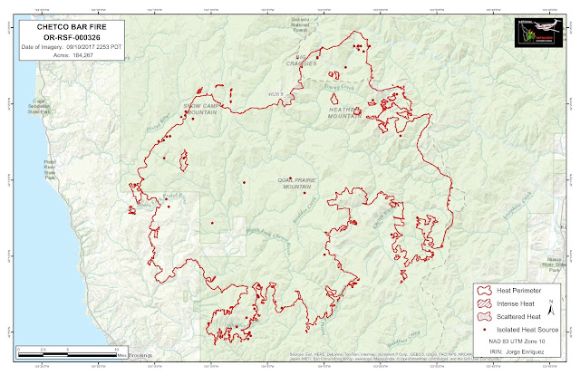

The Chetco Bar fire camp welcomed distinguished visitors on Sunday morning, including Governor Kate Brown, US Forest Service Chief Tony Tooke, Senator Ron Wyden, Major General Michael Stencel, and House Representative Peter DeFazio.
Providing for public and firefighter safety is the top priority for Great Basin Incident Management Team 1. Yesterday saw little growth despite the potential for increased fire activity. The fire area is currently experiencing a warm and dry trend that is expected to last through tomorrow. Higher than average temperatures are expected for today, along with low relative humidities and increased NW winds. This weather pattern has the potential to result in increased fire behavior, but areas of heat are scattered and recent activity has been minimal.
Ground and aviation resources will continue to engage the fire in a safe and effective manner. Engines and hand crews will be patrolling for spot fires and working with helicopters to extinguish existing heat sources along the west side. Fire crews will continue to maintain and enhance containment on completed lines, and construct indirect and contingency lines.
Smoke production is expected to increase today. NE winds will push smoke toward the coastal areas of Gold Beach, Brookings and south into NW California. Highway 101 and local roadways may see reduced visibility in these areas. Moderate to heavy smoke impacts are expected for inland communities surrounding the Chetco Bar fire today. Cave Junction, Grants Pass and areas east of Medford are expected to experience a slow rise in smoke conditions.
Level 3 evacuation orders for areas outside the fire perimeter were reduced to Level 2 as of Friday at 11 am. Residents are urged to remain prepared to evacuate should the need arise.
There will be a community fire briefing in Agness on Tuesday, Sept. 12, 2017. The meeting will be held at 6:30 p.m. in the Agness Community Building, 3927 Cougar Ln, Agness, OR 97406.
The Chetco Bar fire camp welcomed distinguished visitors on Sunday morning, including Governor Kate Brown, US Forest Service Chief Tony Tooke, Senator Ron Wyden, Major General Michael Stencel, and House Representative Peter DeFazio.
Providing for public and firefighter safety is the top priority for Great Basin Incident Management Team 1. Yesterday saw little growth despite the potential for increased fire activity. The fire area is currently experiencing a warm and dry trend that is expected to last through tomorrow. Higher than average temperatures are expected for today, along with low relative humidities and increased NW winds. This weather pattern has the potential to result in increased fire behavior, but areas of heat are scattered and recent activity has been minimal.
Ground and aviation resources will continue to engage the fire in a safe and effective manner. Engines and hand crews will be patrolling for spot fires and working with helicopters to extinguish existing heat sources along the west side. Fire crews will continue to maintain and enhance containment on completed lines, and construct indirect and contingency lines.
Smoke production is expected to increase today. NE winds will push smoke toward the coastal areas of Gold Beach, Brookings and south into NW California. Highway 101 and local roadways may see reduced visibility in these areas. Moderate to heavy smoke impacts are expected for inland communities surrounding the Chetco Bar fire today. Cave Junction, Grants Pass and areas east of Medford are expected to experience a slow rise in smoke conditions.
Level 3 evacuation orders for areas outside the fire perimeter were reduced to Level 2 as of Friday at 11 am. Residents are urged to remain prepared to evacuate should the need arise.
Weather: Monday will be the warmest and hottest day of the week, which may facilitate increased fire behavior. Temperatures could increase to 87o F today, but will decline steadily throughout the week. The marine layer will be absent this morning but may return as humidities rise and temperatures decline. Relative humidity will be in the 20% range during the day on Monday, and increase to 40% at night. A sustained NE wind of 10 mph is expected Monday with gusts up to 25 mph. Wind speed will decrease Tuesday, shifting to NW at a sustained 7 mph, gusting to 12 mph. Lower temperatures and higher humidities are expected later this week with a 10% chance of precipitation forecasted for Tuesday and Wednesday.
Closures and Evacuations: Level 1 and Level 2 evacuation orders remain for portions of Brookings-Harbor and the Upper Winchuck areas. Level 3 evacuations remain for areas within the fire perimeter.
For further information on local forest area closures, see closure order: https://www.fs.usda.gov/Internet/FSE_DOCUMENTS/fseprd558041.pdf
Temporary Flight Restrictions (TFR): There is a TFR over the Chetco Bar Fire. http://tfr.faa.gov/
Fire Size: 182,284 acres
Containment: 5%
Resources: Hand Crews: 43, Helicopters: 7, Engines: 46, Dozers: 20, Water Tenders: 31
Skidders: 2
Total Personnel: 1,534
Location: 5 miles east of Brookings, OR
Started: 07/12/2017
Cause: Lightning
Incident Commanders: Beth Lund, GB Team 1, Melvin Thorton, CFPA
For more information: Visit us on Facebook: https://www.facebook.com/chetcobarfire
See our InciWeb post: https://inciweb.nwcg.gov/incident/5385/#
Call the Information Line: 619-894-9111
Air quality information:https://www.wildlandfiresmoke.net/outlooks/2017/ChetcoBar#Overview


09-10-2017 Chetco Bar Fire Update

09-10-17 West (Curry) Chetco Bar Fire Update
Update: Providing for public and firefighter safety is the incident management team’s top priority.
A warm and dry weather pattern will affect the fire area on Sunday and Monday. This weather pattern is expected to bring higher than average temperatures on Sunday and Monday, along with low relative humidities and NE winds. This weather pattern has the potential to result in increased fire behavior. Fire managers are committed to aggressive operations that provide for community well being while ensuring the safety of personnel.
Crews will continue to construct direct handline and remove brush from contingency firelines. Firefighters will have a better opportunity to seek out and extinguish burning material close to the line, as problem areas will be readily identifiable and residual moisture will allow for more efficient mop-up operations. Along the west side, the main objective will be patrolling for spot fires and continuing mop-up of existing heat sources. To the north, crews are re-establishing some of the firelines created during the 2002 Biscuit Fire, in preparation for possible strategic burning operations.
Air operations are focused on supporting ground resources on both sides of the fire with available aircraft and personnel. Reconnaissance flights and infrared mapping missions are also being conducted.
Moderate smoke impacts are expected in communities surrounding the fire. The majority of impacts will be on the southern portions, as winds from the northeast will drift smoke from the fire over Brookings-Harbor and NW California. These areas could see heavy smoke at times late in the day. Areas north of the fire such as Gold Beach and Agness will see good to moderate smoke conditions. Level 3 evacuation orders for areas outside the fire perimeter were reduced to Level 2 as of Friday at 11 am. Residents are urged to remain prepared to evacuate should the need arise.
Weather: Sunday and Monday will bring a warming and drying trend that may facilitate increased fire behavior. A shallow marine layer on Sunday morning may provide better relative humidity recoveries but will lift by the afternoon and is unlikely to return until later in the week. Humidity will be in the 30% range on Sunday and 20% range on Monday. Poor overnight recoveries are also expected. A sustained NE wind of 8 mph is expected Sunday, with gusts up to 14 mph. Wind speed will increase on Monday, sustained NE at 10 mph, gusting up to 25 mph. After Sunday and Monday, weather is expected to be cooler and wetter.
Closures and Evacuations: Level 1 and Level 2 evacuation orders remain for portions of Brookings-Harbor and the Upper Winchuck areas. Level 3 evacuations remain for areas within the fire perimeter.
See closure order: https://www.fs.usda.gov/Internet/FSE_DOCUMENTS/fseprd558041.pdf
Temporary Flight Restrictions (TFR): There is a TFR over the Chetco Bar Fire. http://tfr.faa.gov/


09-10-17 East Chetco Bar Fire Update
COMMUNITY MEETING TONIGHT in Cave Junction at the Illinois Valley High School at 6:00 pm. Please attend to receive an update on fire activity and to talk to fire managers about their strategies and effort.
Saturday’s Chetco East Zone Fire activity was mostly smoldering and creeping. Monitoring flights observed minimal open flame and the fire stalled at tops of ridges above cool north-facing slopes and sites with green vegetation. This is due to high relative humidity and fuels retaining moisture from recent storms. The northern parts of the fire have shown more active movement than the eastern flank.
Fire crews have made progress tying together sections of well-established containment lines between the fire and Highway 199, totaling approximately 50 miles of fire line. Work is continuing in steep rocky terrain between Josephine Creek and Parker Creek. Crews identified a potential new contingency line route near the Buckskin Peak Trail. It will be closer to the fire than the Biscuit Fire’s dozer line. Masticating equipment is mowing and chipping vegetation along roads to improve them as fire breaks. Fire protection work has been completed around a communication site at Fiddler Mountain and work on Eight Dollar Mountain will continue today. Initial attack crews from the Wild River Ranger District successfully controlled a fifth hold-over lightning-caused fire that came to life, keeping it to ½ acre.
Today, temperatures are expected to be about 10 degrees higher than yesterday with relative humidity dropping to around 30%. Winds out of the northeast are forecast at 5-15 mph on ridgetops. These conditions along with drying fuels will likely influence more active fire behavior than yesterday, but still relatively quiet.
Today, hand crews will continue work closing small gaps in the fire lines on the eastern flank. Alternate fire line routes continue to be scouted in the Buckskin Peak Trail area. Hand line work will continue between Tennessee Pass and Madison Gulch. Masticator equipment will remove roadside vegetation in the Rough and Ready Flat area and to the south. Dozer lines from the Biscuit Fire will continue to be reopened pushing to the north. Initial attack crews will respond to new starts and spot fires and an additional helicopter will be available to the fire. Tonight, a subsidence inversion over the fire area will result in relative humidity dropping overnight. This early dryness could result in higher nighttime fire activity.
Smoke: An air quality alert is in effect for Curry and Josephine counties. For current air quality information and forecasts go to http://oregonsmoke.blogspot.com.
Closures and Restrictions: Many areas and activities are closed or restricted due to current and expected fire activity and hazard. More details are available on https://inciweb.nwcg.gov/incident/closures/5385/ People can view maps of the current Evacuation Notification areas at http://arcg.is/1LmzPe. By typing their address into the search bar on the upper right, they can see where their home is located in relation to the current Evacuation warnings.
Fire at a Glance:
Size: 184,207 acres
Started: July 12, 2017 by Lightning
Containment: 5%
Assigned Resources:
Helicopters shared across the Chetco Bar Fire: 2 Type 3; 2 Type 2; 1 Type 1; 3 National Guard Type 1
Ground resources on the Chetco East Zone: 9 Type 2 crews; 9 Engines; 6 Fallers; 6 Dozers; 1 Water Tender; 3 Masticators; 1 Skidder

09-10-17 Chetco Bar Fire Smoke Outlook
COMMUNITY MEETING TONIGHT in Cave Junction at the Illinois Valley High School at 6:00 pm. Please attend to receive an update on fire activity and to talk to fire managers about their strategies and effort.

Smoke: Smoke impacts today will vary from light to heavy in communities surrounding the Chetco Bar fire. Light Northerly winds will drift smoke generally South and down
drainages into communities such as Brookings-Harbor. A rise in smoke this morning is likely in these coastal communities South of the fire before clearing later in the afternoon. Inland communities, including Cave Junction, will see a slow rise in smoke impacts through the day that may reach Unhealthy at times by the afternoon/evening. Areas North and West of the fire, such as Gold Beach and Agness, are expected to see Good/Moderate conditions and
possible haze overhead. With warmer and drier weather developing this weekend, smoke impacts are likely to slowly increase with a forecast increase in fire activity.


09-09-17 Chetco Bar Fire Update Curry and Josephine Counties

09-09-17 West (Curry) Chetco Bar Fire Update
Weather and Fire Behavior: The recent rainfall and high humidity led to minimal fire activity, best described as creeping and smoldering with little perimeter movement. Later in the day on Thursday, temperatures were noticeably warmer, signaling the beginning of a warming and drying trend that is expected to continue through Monday. Smoke impacts today will vary from light to heavy in communities surrounding the Chetco Bar fire.
Today, during the morning hours, there will be smoke and fog in some areas with clearing in the afternoon. Skies will be partly sunny, temperatures in the mid 60’s with 5-10 MPH winds from the northwest. As humidity levels begin to drop and temperatures begin to rise, vegetation will begin to dry out, leading to increasingly active fire behavior with surface spread, fire backing downhill and making flanking runs uphill. Fire could climb to the tops of trees (isolated torching) in areas where wetting rain did not occur.
Yesterday: Clouds, smoke and fog hung over the fire area until late morning Friday. Weather allowed for further strengthening of containment lines while crews moved operations closer to the fire’s perimeter, building line directly along the fire’s edge where it was safe and effective to do so. This effort is intended to reduce potential impacts to nearby private lands. Crews patrolled existing spot fires and remained vigilant for evidence of new ignitions from lightning or spot fires that have not yet been detected.
Great Basin Incident Management Team 1 arrived on Thursday to begin shadowing, or gathering information, from their counterparts on Pacific Northwest Team 3. The two teams will transfer command of the Curry County portion of Chetco Bar Fire on Sunday morning.
Today: Crews have been on the offensive the last couple of days and will continue to take advantage the moderated fire behavior as long as it lasts by further strengthening containment lines, building more direct line and reducing the potential footprint of the fire.
As the warming and drying trend continues, fire activity will increase on the south and southwest fire perimeter and crews are ready to make that transition. Crews will construct and remove brush from contingency firelines so that they can better hold when tested. Along the west side, firefighters will patrol for spot fires and continue to mop-up the existing spot fires. To the north, crews are re-establishing some of the previous Biscuit Fire dozer lines, in preparation for bringing fire down to containment lines in a deliberate fashion that would remove ground vegetation and add depth to improve effectiveness of those lines. Structure assessment for communities of Agness and Curry County Oak Flats continues.
Evacuations: Evacuations remain in Curry and Josephine County and will be evaluated daily. Residents are encouraged to monitor the interactive evacuation map for changes: http://arcg.is/2vWQN2N
Shelters: The Tolowa Dee-ni’ Nation is operating a shelter at the Xaa-wan’-k’wvt Village & Resort (old Ship Ashore) RV Park located at 12370 Highway 101 North in Smith River.
Closures: Several large wildfires are burning in southwest Oregon. Area closures have been implemented on the Rogue River – Siskiyou National Forest and BLM lands. Fire restrictions are in place: https://inciweb.nwcg.gov/incident/closures/5385/
Air resources will support firefighting efforts as visibility and weather permit.

09-08-17 East Chetco Bar Fire Update
Friday was the first day of a drying and warming trend over the Chetco East Zone Fire area that will continue through Monday. Thursday’s wetting rain reduced fire activity providing a good opportunity for crews to continue making progress on fire line construction. However, fuels were only temporarily dampened and are already beginning to dry out. A fourth new fire, ignited by lightning Thursday, came to life and was controlled by Wild Rivers Ranger District firefighters. Dean Warner, Fire Behavior Analyst with Northwest Incident Management Team #13, observed that roads are already drying out and vehicles are kicking up dust again.
Today’s temperatures are expected to reach 84 degrees in the valleys and 72 degrees on the ridges. The minimum relative humidity will be in the 30’s. Winds of 4-8 mph are expected out of the north. With warming temperatures and lower relative humidity, fire activity is expected to be primarily smoldering and creeping, with low possibility of short uphill runs. Spotting is not expected.
With clearing skies on Friday, fire managers were able to fly helicopters for reconnaissance of fire activity. Although most of the Chetco East Zone Fire is quiet with little heat along the perimeter, there was significant smoke being produced on the north perimeter of the fire at the “horseshoe” bend in the Illinois River around South Bend Mountain and also near Heather Mountain.
Approximately 40 miles of old Biscuit Fire containment dozer lines have been reopened and completed east of the fire. New sections of dozer line were completed east of York Butte (2 miles) and west of Chrome Ridge to Flat Top (3.5 miles). Today hand crews will work along a rocky area above the headwaters of Parker Creek to improve an existing hand line to connect dozer lines. Others will continue progressing north toward Bear Camp. As containment lines are completed farther to the North and fire behavior moderates, more direct fireline routes will be scouted. If there are safe, accessible anchor points closer to the fire, then “direct” firelines can be built closer to the areas that are currently burning.
The Oregon National Guard is assisting with several efforts associated with the Chetco Bar Fire. Approximately 214 are serving as firefighters, roadblock security and support in Curry County. In the East Zone (Josephine County), ten are providing security at road closures and approximately twenty are supporting 3 National Guard Type 1 helicopters.
Fire Size: The entire Chetco Bar Fire is about 184,208 acres. The fire edge remains approximately 8-10 miles west of private land and communities along Highway 199 in Josephine County.
Other activities: Today, uniformed Illinois Valley Fire District personnel will be conducting structure assessments in the communities of O’Brien (Lone Mountain, Naue Way), Cave Junction (Westside Rd, Airport Rd) and Selma (Illinois River Rd). They are collecting information about the number and condition of buildings (roofing material, driveway access, vegetation type, slopes) that will be important for future fire protection. They record this fire safety information in case it is needed in the future. There is not an imminent fire risk now.
Smoke: Heavy smoke has affected Josephine County for many days. A welcome partial clearing of smoke in the valleys was observed Friday. Today’s smoke level in Grants Pass and Cave Junction is forecast as “unhealthy”. This means more people than average may have breathing problems. Everyone should limit time outdoors if possible and avoid exercising outdoors. People with asthma, respiratory infection, diabetes, lung or heart disease, or have had a stroke should avoid all physical outdoor activity. Public information about forest fires and smoke conditions is available at http://oregonsmoke.blogspot.com.
Closures and Restrictions: Many areas and activities are closed or restricted due to current and expected fire activity and hazard. More details are available on https://inciweb.nwcg.gov/incident/closures/5385/ The BLM has closed its trailhead at Eight Dollar Mountain. The Oregon National Guard is now providing 24-hour staffing at closure area roadblocks on Illinois River Road and Eight Dollar Mountain Road.
In Josephine County, a Level 1 “Ready” Evacuation Notification affects private and BLM land on the west side of Hwy 199 from Hayes Hill to the California border. This action is intended to raise awareness of fire in the vicinity and get people thinking about necessary steps they would take if asked to evacuate. About ten miles along the Illinois River Road from the National Forest boundary located two miles west of Selma to Oak Flat is under Level 3 “Go” Evacuation Notification. Residents were advised to leave this area and it is closed to everyone except firefighting personnel. People can view maps of the current Evacuation Notification areas at http://arcg.is/1LmzPe. By typing their address into the search bar on the upper right, they can see where their home is located in relation to the current Evacuation warnings.
There is a Community Meeting planned for Sunday, September 10 at 6:00 pm at the Illinois Valley High School in Cave Junction. People are encouraged to attend to receive an update on fire activity and to talk to fire managers about their strategies and effort.
Fire at a Glance:
Size: 184,208 acres
Started: July 12, 2017 by Lightning
Containment: 5%
Resources:
Helicopters shared across the Chetco Bar Fire: 2 Type 3; 2 Type 2;
1 Type 1; 3 National Guard Type 1
Ground resources on the Chetco East Zone: 7 Type 2 crews; 9 Engines; 6 Fallers; 6 Dozers; 2 Water Tenders; 2 Masticators; 1 Skidder

Smokey View: Swinging Bridge, Illinois River Sept. 7
Posted on: 09/08/17 01:18 pm
09-08-17 Chetco Bar Fire Update Curry and Josephine Counties
09-08-17 West Chetco Bar Fire Update
Weather and Fire Behavior: Yesterday’s weather pattern continues into late morning today. Where it occurred, rainfall and high humidity levels greatly reduced fire activity and growth yesterday and overnight. Smoldering and slow burning continued beneath the forest canopy.Larger vegetation remains dry though, and as temperatures rise and humidity levels drop again over the next 72 hours, fire activity will pick up. Areas where little activity occurred yesterday may hide burning roots that, when winds increase and humidity levels drop, will spread to nearby receptive fine fuels like grasses, leaves and small twigs.
Yesterday: Poor visibility associated with the weather prevented aircraft (including last night’s scheduled infrared flight) from operating. Firefighters on the northwest fire perimeter were successful in getting containment lines around about 75% of the spot fires caused by the winds a few days prior.
With the weather reducing the intensity of the fire, crews working on the western perimeter were able to move in closer to the fire’s edge and build more direct containment lines. On the southwest edge, operations continued to hold and improve firelines while at the same time deploying more hose lines to be used in securing those lines. The north side was able to connect and tie in to lines in Josephine County to the east. Scouting and constructing firelines to the south into California continues. The recent rain and high humidity levels delayed implementing strategic burning operations that would consume fuel between the main fire and containment lines; adding depth and strengthening existing lines.
Today: Moderated weather is allowing for further strengthening of containment lines as well as opportunities to move in closer to the fire perimeter, thereby reducing potential impacts to nearby private lands. Firefighters will continue to remove brush and vegetation along containment and contingency lines, and ensure that hoselays are in place and functioning properly. Ongoing efforts include patrols for spot fires, extinguishing areas of heat within spot fires, fireline construction and, where containment lines have been secured by mop-up, fireline repair work (re-contouring lines to mitigate water runoff).
North of the fire at the confluence of the Illinois and Rogue rivers, structure assessment and preparation continues in the community of Agnes.
Air resources remain poised to respond as conditions change.
Oregon State Fire Marshal resources have completed their assigned tasks but are ready to return to the area should the need arise. As humidity levels begin to drop and temperatures begin to rise, vegetation will dry out over the next 24 to 48 hours. Hazards faced by firefighters in the current conditions include: access to wet areas with steep slopes with dirt roads and trees, weakened by fire, are more susceptible to falling as wet soils loosen their hold on root systems.
Evacuations: Evacuations remain in Curry and Josephine County and will be evaluated daily. Residents are encouraged to monitor the interactive evacuation map for changes: http://arcg.is/2vWQN2N
Shelters: The Tolowa Dee-ni’ Nation is operating a shelter at the Xaa-wan’-k’wvt Village & Resort (old Ship Ashore) RV Park located at 12370 Highway 101 North in Smith River.
Closures: Several large wildfires are burning in southwest Oregon. Area closures have been implemented on the Rogue River – Siskiyou National Forest and BLM lands. Fire restrictions are in place: http://bit.ly/2erUN5B.

09-08-17 East Chetco Bar Fire Update
Yesterday: Thursday was wet across much of the Chetco East Zone Fire. After numerous, sometimes intense, showers, some places had received ¼ to ½ inch of precipitation. Some sites even received a full inch of rain. “Will this help the fires?” was a frequent, hopeful question voiced by community members. “Every bit of rain helps,” said Operations Section Chief Pat Halford. “It temporarily raises the humidity, dampens the fuels, reduces fire activity and slows fire growth.” However, the rains were not evenly distributed and, especially in thick brush and under a forest canopy and large dead logs, the rain didn’t penetrate or wasn’t sufficient to make a difference. The fine fuels will dry out quickly as weather begins to warm again. Firefighters will be taking advantage of this respite to continue their work. They will be attentive to the locations where more active fire potential still exists and the time it will return. Weather will dry out, heat up, and become more windy from Saturday to Monday.Unfortunately, lightning associated with the rain diverted some of the firefighting equipment and resources to high priority initial attack work. For example, three new fires on the Wild Rivers Ranger District required suppression. Two were controlled at 1/10 acre, but the third (2 acres) was lined and will continue to be worked today. We can’t control lightning, but everyone should continue to be careful with fire and their vehicles in order to prevent new fires from starting.
Today: Today’s work includes finishing almost all the structure protection planned along the Illinois River Road’s Level 3 “Go!” Evacuation Notification corridor. The roof at the Store Gulch Guard Station became too slippery for firefighters applying the last pieces of protective foil fabric, so that work remains. The communication sites at Eight Dollar Mountain and Fiddler Mountain will be further assessed for their protection needs today.
Biscuit Fire containment dozer lines from the California border to Squaw Mountain (about 4 ½ miles west of Hayes Hill) have almost fully received at least one pass of a dozer, which is being followed by fallers removing snags and five 20-person hand crews brushing and cleaning remaining flammable materials away. There’s a rocky area above the headwaters of Parker Creek that will be evaluated to see whether it’s adequately prepared to block fire. As these projects are completed, containment line re-opening work will be extended to the North.
As containment lines are completed and fire behavior moderates, more direct fireline routes will be sought, from safe anchor points, closer to the areas that are currently burning.
Fire Size: The entire Chetco Bar Fire is about 177,301 acres. No infrared flight was completed last night, but the fire was not actively spreading. It is approximately 8 miles from private land outside the National Forest boundary and communities in Josephine County, east of the fire.
Smoke: Heavy smoke has affected many parts of Josephine County for many days. The rain removed some of the particulates, improving smoke levels one to two categories, such as from “unhealthy” to “unhealthy for sensitive groups” or even to “moderate.” Today’s smoke level in Grants Pass is forecast as “moderate” indicating that people with asthma, respiratory infection, diabetes, lung or heart disease, or have had a stroke should limit outdoor activities or do activities that take less effort, such as walking instead of running. Public information about forest fires and smoke conditions is available at http://oregonsmoke.blogspot.com.
Closures and Restrictions: Many areas and activities are closed or restricted due to current and expected fire activity and hazard. More details are available on https://inciweb.nwcg.gov/incident/closures/5385/
The BLM has closed its trailhead at Eight Dollar Mountain.
In Josephine County, a Level 1 “Ready” Evacuation Notification affects private and BLM land on the west side of Hwy 199 from Hayes Hill to the California border. This action is intended to raise awareness of fire in the vicinity and get people thinking about necessary steps they would take if asked to evacuate. About ten miles along the Illinois River Road from the National Forest boundary located two miles west of Selma to Oak Flat is under Level 3 “Go” Evacuation Notification. Residents were advised to leave this area and it is closed to everyone except firefighting personnel. People can view maps of the current Evacuation Notification areas at http://arcg.is/2vWQ2N. By typing their address into the dark blue line, they can see where their home is located in relation to the current Evacuation warnings.
Community Meeting: There is a Community Meeting planned for Sunday, September 10 at 6:00 pm at the Cave Junction High School. People are encouraged to attend to receive an update on fire activity and to talk to fire managers about their strategies and effort.
Fire at a Glance:
Size: 177,301 acres
Started: July 12, 2017 by Lightning
Containment: 5%
Resources: Helicopters shared across the Chetco Bar Fire: 2 Type 3; 2 Type 2; 1 Type 1; 3 National Guard Type 1
Ground resources on the Chetco East Zone: 5 Type 2 crews; 5 Engines; 6 Fallers; 5 Dozers; 1 Water Tender; 1 Masticator; 1 Skidder
09-08-17 Chetco Bar Fire Smoke Outlook
For a downloadable, emailable PDF of this update, click here.
Smoke impacts improved dramatically in all communities surrounding the Chetco Bar fire overnight.
Rainfall and wind have helped to clear the air, however, lingering smoke remains in many areas. Inland communities such as Cave Junction, Grants Pass and the Rogue River Valley cleared out overnight but conditions are expected to degrade, possibly reaching the Unhealthy range later today. Coastal areas South of the fire, such as Brookings, that were mostly free of smoke overnight, are
seeing smoke drain down valley and fill back in this morning. These areas may see periods of Unhealthy conditions with overall impact in the Unhealthy for Sensitive Groups range. With warmer and drier weather tomorrow, smoke impacts are likely to increase with a forecast increase in fire activity.


Weather and Fire Behavior: A Flash Flood Watch is in effect through 11 PM tonight for northern California and southern Oregon. If the predicted thunderstorms produce excessive rainfall in previous wildfire burn scars, debris flows and/or mudslides may occur in drainages. Expected fire behavior includes surface fire spread and isolated incidences of fire climbing to the tops of individual trees.
The weather pattern will begin to change late Friday with temperatures rising and humidity levels falling through the weekend. Heavy smoke impacts continue for inland communities surrounding the Chetco Bar fire this morning. Cave Junction, Grants and Pass and to the East past Medford remain under dense smoke. Coastal areas such as Brookings and Gold Beach have seen dramatic improvement in smoke levels due to onshore Westerly flow lifting smoke out. Today, thunderstorms, possible rainfall and gusty winds will help to mix out smoke in inland communities. Overall, there is an expected improvement in air quality today.
Yesterday: Weather moderated fire behavior so that less spreading occurred. Task forces worked preparing structures along the California border while crews continue to use the cooler temperatures from the last couple of days to both lengthen and widen control lines and wait for conditions to improve in favor of burnouts along lines south of Mt. Emily. Northwest Team 13 took command of the east side of the fire (in Josephine County) last night.
Today: Firefighters are taking advantage of this break in weather by constructing more fireline as well as clearing brush to strengthen existing firelines below the southwest perimeter of the fire. They are taking advantage of opportunities to build direct fireline where doing so would be effective and can be done safely. Patrolling and mopping up spot fires to prevent their further spread is continuing along the western perimeter as is scouting/building of direct and indirect lines along the north and northeast.
Crews are scouting and preparing firelines for strategic burning operations. Line construction and firebreak enhancement continues below the southwest perimeter of the fire. Patrolling and mopping up of spot fires is continuing along the western perimeter, and scouting/building of direct and indirect lines along the north and northeast is also continuing. Structure protection is continuing in Store Gulch, Oak Flat, McCaleb’s Ranch, and Footbridge along the Illinois River valley in Josephine County.
In coordination with the local Forest Service and the Oregon Department of Forestry (ODF), heavy equipment will continue to be utilized to open previously-used fire lines as part of a containment operation east of the Kalmiopsis Wilderness. As visibility and weather allow, aircraft will support firefighters.
For a downloadable, emailable map, click here.

Evacuations: Evacuations remain in Curry and Josephine County and will be evaluated daily. Residents are encouraged to monitor the interactive evacuation map for changes: http://arcg.is/2vWQN2N.
Shelters: The Tolowa Dee-ni’ Nation is operating a shelter at the Xaa-wan’-k’wvt Village & Resort (old Ship Ashore) RV Park located at 12370 Highway 101 North in Smith River.
Closures: Several large wildfires are burning in southwest Oregon. Area closures have been implemented on the Rogue River – Siskiyou National Forest and BLM lands. Fire restrictions are in place:https://www.fs.usda.gov/detail/rogue-siskiyou/notices/?cid=FSEPRD558039.
09-07-17 Chetco Bar Fire Smoke Outlook
For a downloadable, emailable PDF of this update, click here.
Fire: Low/Moderate fire behavior is expected as cool and wet weather moves in. A Red Flag Warning is in effect for lightning today. The fire is 177,301 acres burned and is 5% contained.
Other: Gold Beach, Agness and Brookings smoke monitors are currently being fixed. We hope to have the Brookings monitor back up today.


9-06-17 Chetco Bar Fire Daily Update

Join us for a community fire briefing 6:00 p.m. tonight, at Brookings-Harbor High School, 625 Pioneer Road.
Weather and Fire Behavior: A red flag warning is in effect through Wednesday for abundant lightning in areas of dry vegetation. New fire starts from lighting, along with gusty and erratic winds near the storm area, are a concern. Embers have the potential to carry up to 1/3 of a mile from the main fire. Improved humidity recovery overnight and a 15 percent chance of wetting rain are predicted for today. While the amount of rain forecast may moderate fire behavior, it would not be enough to extinguish the Chetco Bar Fire.
Yesterday: Firefighters took advantage of the cooler temperatures and increased humidity levels that slowed fire spread on Tuesday. Improved air quality on the western flank gave helicopters more opportunities to perform bucket drops, helping to further slow the spread of the fire. Crews have made good progress and have completed the structure preparation work in the Oak Flats in Josephine County. On the western flank of the fire, crews secured spots from previous day’s fire runs and continue line prep to the north toward Snowcamp.
Today: Line construction continues; connecting dozer lines and roads into the Pistol River. Firefighters are patrolling for spot fires, providing structure protection and maintaining hoselays along firelines. With the help of Dozers, they are re-establishing containment lines previously used during the Biscuit fire.
As weather and fuel moistures allow, firefighters will strengthen containment lines by using fire to consume ground vegetation between the main fire and containment lines. Considerations factored into decisions about burning include resources available, predicted and current weather, and terrain, along with the type and moisture level of vegetation. If the opportunity presents itself today, firefighters will implement this tactic in the Winchuck drainage.
Cal Fire resources have begun creating contingency lines to the south in California. Resources will continue to prioritize, contain and mop up spot fires to lessen the threat to values at risk.
Northwest Incident Management Team 13 will take command of the east side of the fire tonight at 8:00 pm. Zoning the fire to assign incident management teams to each side will provide opportunities for focused attention in the areas of most concern to communities.

Evacuations: Evacuations remain in Curry and Josephine County and will be evaluated daily. Residents are encouraged to monitor the interactive evacuation map for changes: http://arcg.is/2vWQN2N.
Shelters: The Red Cross evacuation center is located at the Nazarene Church at 1600 Chetco Ave. in Brookings, OR (541)-600-6068. Tolowa Dee-ni’ Nation is also operating a shelter at The Xaa-wan’-k’wvt Village & Resort (old Ship Ashore) RV Park located at 12370 Highway 101 North in Smith River.
Closures: Several large wildfires are burning in southwest Oregon. Area closures have been implemented on the Rogue River – Siskyou National Forest and BLM lands. Fire restrictions are in place: http://bit.ly/2erUN5B.
9-06-17 Chetco Bar Area Smoke Forecast
For a downloadable, emailable PDF of this update, click here.
Smoke: Heavy smoke impacts continue to be seen in local communities this morning surrounding the Chetco Bar Fire. This includes Brookings, Agness, Grants Pass, and Cave Junction. South and Southwesterly winds today will help mix in clearer air in coastal areas such as Gold Beach and Brookings. Communities to the East and North (as well as South due to fire activity in NW California) may see some improvement as well with possible rainfall and gusty winds. However, these inland areas are expected to remain in the Unhealthy to Very Unhealthy range in general. Higher elevation smoke from the numerous fires in the region will drift to the North and West where hazy skies over the Western portion of Oregon, including the coast, are expected.
Fire: Moderate fire behavior is expected as cooler weather conditions move in. A Red Flag Warning is in effect for lightning today. The fire is 176,770 acres burned and is 5% contained.
Other: The Gold Beach, Agness, and Brookings smoke monitors are currently being fixed. We hope to have the Brookings monitor back up today.


Chetco Bar Fire Community Briefing September 6, 2017 6pm Brookings
Incident: Chetco Bar Fire Wildfire
Chetco Bar Fire Community Briefing Sept 9/6/17 6pm (jpeg 308 kb)
Chetco Bar Fire Community Briefing 9/6/17 6pm (jpeg 308 kb)
Community Fire Briefing
Wednesday, September 6, 2017 at 6:00 p.m. Brookings-Harbor High School
625 Pioneer Road, Brookings, Oregon
Fire managers will provide an operational update about the Chetco Bar Fire.
9-05-17 Chetco Bar Fire Daily Update
For a downloadable, emailable PDF of this update, click here.
Yesterday: Numerous spot fires were ignited by embers being cast across containment lines. The east side of the fire pushed 4.5 miles to the south and east prompting increased evacuation levels on Illinois River Road. Fire activity on the west flank led to a change from level 2 to level 3 in some areas.
Multiple air resources, including a heavy helitanker, took advantage of the improved visibility to aid firefighting operations. Good progress was made on the Illinois river road and crews wrapped approximately 80 percent of the structures in that area.
Today: Fire resources will continue to promptly identify, prioritize, and suppress or contain spot fires while holding and improving existing containment lines. In addition to fireline construction, the direct and indirect fireline work includes crews and dozers improving, or reopening, fireline that was constructed 15 years ago during the Biscuit fire and improving roads to be used as containment lines.
To stop or slow fire growth, crews may strategically burn the vegetation between the main fire and containment lines. These operations would include careful consideration of terrain, vegetation, and predicted fire weather. Structure protection will continue in the Josephine County Oak Flat area. Two additional Oregon Office of the State Fire Marshall task forces will be arriving to join in structural fire suppression efforts. An incident management team will begin to arrive and will be taking command of the east side of the fire over the next couple of days.
For a downloadable, emailable map, click here.

Evacuations: In Josephine county, a level 3 evacuation order is in place for all residents on Illinois River road within the Forest Service boundaries, including the Oak Flat community. A level 3 evacuation is also in affect in Curry county along the Carpenterville Road, north of the Cape Ferrelo Road intersection to the Carpenterville Road and Bosley Butte Road intersection. A Level 1 evacuation order has been issued for the residents of the Illinois Valley west of Highway 199 from Hayes Hill to the California state line. Residents are encouraged to monitor the interactive evacuation map for changes: http://arcg.is/2vWQN2N.
Shelters: The Red Cross evacuation shelter is in Gold Beach at the Curry County Fairgrounds is relocating to the Nazarene Church 1600 Chetco Ave in Brookings, OR (541)-600-6068. Tolowa Dee-ni’ Nation is also operating a shelter at The Xaa-wan’-k’wvt Village & Resort (old Ship Ashore) RV Park located at 12370 Highway 101 North in Smith River.
Closures: Several large wildfires are burning in southwest Oregon. Area closures have been implemented on the Rogue River – Siskyou National Forest and BLM lands. Fire restrictions are in place: http://bit.ly/2erUN5B.
9-05-17 Chetco Bar/Southwest Oregon Smoke Forecast
For a downloadable, emailable PDF of this update, click here.
Smoke: Heavy smoke continues to settle in communities down valley from the Chetco Bar fire in
all directions. Inland communities such as Agness, Cave Junction and Grants Pass are expected to remain in the Very Unhealthy range through today and into tomorrow. Coastal communities are expected to get a slight reprieve this afternoon as light Southwest winds and onshore flow help to drive smoke inland. Smoke will settle back into these areas overnight. In general, the coast (including Gold Beach and Brookings) should average Very Unhealthy conditions.
Other: The Gold Beach, Agness and now Brookings smoke monitors are all experiencing flow issues. We are working to get these fixed as quickly as possible.
Fire: Active fire behavior is expected again today as critical burn conditions exist. The fire is 167,513 acres burned and is 5% contained.


Chetco Bar Evacuation
JOINT PRESS RELEASE: Level 3 Evacuation Notice Along Illinois River Road
Dates: September 4, 2017 12:00 pm
Under the recommendation of the Chetco Bar Fire Incident Commander with concurrence of the Josephine County Sheriff’s Office and the Illinois Valley Fire District, a Level 3 evacuation order has been issued for all residents on Illinois River Road within the US Forest Service Boundaries. This includes the Oak Flat Community.
A Level 3 “GO” Evacuation means that you need to LEAVE IMMEDIATELY! Danger to your area is current or imminent, and you should evacuate immediately. If you choose to ignore this advisement, you must understand that emergency services may not be available to assist you further. DO NOT delay leaving to gather any belongings or make efforts to protect your home. Access to evacuated areas may be denied until conditions are safe for citizens to return. DO NOT plan to return to check on your house or animals. If it is not safe for you, it is not safe for them!
The US Forest Service has closed Illinois River Road and is turning back public traffic along the Illinois River Road. We strongly advise travelers to avoid this area so the appropriate law enforcement and wildland firefighter resources can respond to this emergency.
A Level 1 “Be Ready” evacuation order has been issued for the residents of the Illinois Valley west of Highway 199 from Hayes Hill to the California state line. This is a precautionary measure to insure residents are aware of changing conditions and wind driven fire behavior.
A Level 1 “Be Ready” Evacuation means that you should be aware of the danger that exists in your area, monitor emergency services websites and local media outlets for information. This is the time for preparation and precautionary movement of persons with special needs, mobile property and (under certain circumstances) pets and livestock. If conditions worsen, emergency services personnel may contact you via an emergency notification system.
Chetco Bar Fire Information can be reached at 541-469-1177.
http://tinyurl.com/ChetcoBar-EvacuationMapYesterday: Fire behavior was very active in several areas around the fire perimeter. On the eastern flank, a significant smoke column developed to a height of 23,000 feet in the early afternoon to the south. The fire spotted over Forest Road 1983 and became established in the Wheeler Creek drainage. High temperatures and critically low humidity contributed to the increase in fire behavior. Shifting winds in the afternoon improved visibility, allowing aircraft to support ground operations with water drops on portions of the fire. Crews continued to connect roads, dozer lines and handline to form direct and indirect containment lines.Well over 500 people attended the community fire briefing in Cave Junction last night. Fire officials described the regional and national fire situation then discussed operations and the strategy for the Chetco Bar Fire.
Today: Firefighters will continue installing sprinkler systems and clearing brush to protect structures in Oak Flats in Josephine County and to the north toward Agness. Crews will seek out and extinguish sources of heat near the containment line (mop-up), and deploy hose along the fire perimeter to be used as fire reaches containment lines or to aid in burnout or mop-up operations. Focus today will also be on the southwest flank of the fire between Emily Creek and the Winchuck area as north winds push the fire southwest toward containment lines. Crews will continue working to slow the fire spread from the Winchuck drainage.
For a downloadable, emailable map of this update, click here.

Smoke & Air Quality: The forecasted northerly wind shift will drift smoke south, impacting Brookings and Cave Junction. Communities to the north and west, such as Gold Beach, are expected to see improving air conditions. This may give aviation further opportunities to engage the fire. Conversely, those same winds can also increase or cause erratic fire activity.
Evacuations: Evacuations remain in place in Curry and Josephine Counties. The Red Cross evacuation center is located in Gold Beach at the Curry County Fairgrounds. Residents are encouraged to monitor the evacuation map for changes http://arcg.is/2vWQN2N.
Shelters: The Red Cross evacuation shelter is in Gold Beach at the Curry County Fairgrounds showcase building, 29392 Ellensburg Avenue. Tolowa Dee-ni’ Nation is also operating a shelter at The Xaa-wan’-k’wvt Village & Resort (old Ship Ashore) RV Park located at 12370 Highway 101 North in Smith River. Residents are encouraged to monitor the interactive evacuation map for changes: http://arcg.is/2vWQN2N.
Closures: Several large wildfires are burning in southwest Oregon. Area closures have been implemented on the Rogue River – Siskyou National Forest and BLM lands. Fire restrictions are in place: http://bit.ly/2erUN5B.
Note: There was no infrared flight last night. Data from these flights is used in verifying fire perimeter and calculating acres burned. Therefore, acreage is an estimate.
Join us for a Community Fire Briefing tonight at 7 p.m. in Cave Junction at the Illinois Valley High School.
Weather and Fire Behavior: There is potential for very active fire behavior again today. With embers carrying up to three tenths of a mile, significant perimeter growth is possible. The Excessive Heat Warning continues through midday Monday. A Red Flag Warning will be in effect tonight through Monday morning for gusty winds, low relative humidity, and high to very high fire danger all of which are likely to contribute to significant spread of new and existing fires. From the northwestern edge of the fire, firefighters observed temperatures over 100 degrees for more than six hours Saturday afternoon.
Yesterday: With variable and weak winds aloft, smoke dispersion was poor and smoke settled into Brookings and other low areas. While the smoke moderated fire behavior in some areas, when it cleared, activity picked up and a column of smoke rose to 12,000 feet on the east side of the fire.
West of Cave Junction, crews re-opened and cleared brush from firelines used during the Biscuit Fire. On the north, northwest, and southern perimeter, firefighters continued to connect dozer lines with road systems, establishing direct containment lines. Crews performed structural assessments and pulled burnable material away from structures in the Illinois River Valley and Agness areas. A single helicopter flew yesterday, but air resource use was severely limited by smoke.
Today: Finding and extinguishing hot spots along the containment line on portions of the west and northwest side of the fire is an ongoing effort. On the eastern flank, firefighters will re-open old dozer lines southwest of Cave Junction and engine crews will prepare structures by pulling back burnable material and installing sprinkler systems. Firefighters are planning to construct contingency fireline to the south into California. Aircraft utilization is expected to be minimal as pilots are hampered by dense smoke and limited visibility. Oregon State Fire Marshal structural task forces are patrolling and assessing structural properties in the level 2 and 3 evacuation areas.
On the southwest flank of the fire, firefighters continue to check (or slow) southerly fire spread into the Emily creek area. Mop-up is ongoing on the western perimeter while crews continue line construction and potentially some burnout operations to secure Pistol River firelines. Extreme to Hazardous smoke impacts will continue to immerse the communities downwind of the Chetco Bar fire on all sides. Reduced visibility along highways 101, 199, and other local roadways should be expected. Coastal areas such as Gold Beach and Brookings, and possibly Agness, are expected to see some improvement in smoke conditions late in the day as West to Northwest winds begin to drift smoke Southeasterly. Inland communities such as Cave Junction and Grants Pass that sit down valley are expected to remain in heavy smoke through tomorrow.
Note: There was no infrared flight last night. Data from these flights is used in verifying fire perimeter and calculating acres burned. Therefore, an update to the fire size is unavailable today.
Evacuations: The level 3 evacuation was decreased to a level 2 for the Mountain Drive area off the north bank of the Chetco. A level 1 “be prepared” evacuation was put in place today for the Oak Flats area in Josephine County.
Closures: Highway 101 remains open, as well as local restaurants, businesses, and lodging establishments in Brookings and Harbor. Several large wildfires are burning in southwest Oregon. Area closures have been implemented on the Rogue River – Siskyou National Forest and BLM lands. Fire restrictions are in place: http://bit.ly/2erUN5B.
9-02-17 2:30 p.m. Chetco Bar Fire Evacuation Update
At 10:00 a.m. this morning, the Josephine County Sheriff issued a Level 1 evacuation for Oak Flats, east of the Chetco Bar Fire.
Level 1 is the "Ready" in Ready-Set-Go. It means 'Be Prepared'.
Residents should be aware of the danger that exists in their area, monitor emergency services websites and local media outlets for information.
This is a time for preparation and precautionary movement of persons with special needs, mobile property and (under certain circumstances) pets and livestock.
To sign up for evacuation alerts for your area of Josephine County, use the Josephine County Alert (Reverse 911) system at http://www/co/josephine.or.us/
9-02-17 11:00 a.m. Chetco Bar Fire Evacuation Order Update
For a downloadable, emailable PDF of this update, click here.
Evacuation Area Re-entry Plan: “ADDITIONAL AREA”
Based upon current fire behavior, availability of resources and in coordination with the Chetco Bar Incident Management Team, the Curry County Sheriff’s Office has reduced the area currently under a Level 3 Evacuation to a Level 2 for the area of Mountain Drive off of the North Bank of the Chetco River Road. All of Mountain Drive including Van Pelt Drive, Thomas Lane, Canyon Drive, E. Cougar Drive, and W. Cougar Drive are now within the Level 2 Evacuation level.
All residences and businesses within this current Evacuation zone previously described will be allowed to return.
All residents that live in this geographic area are asked to present their picture identification to Curry County Sherriff’s Office Staff to receive re-entry materials. Residents must pick up the re-entry materials from 11am to 2pm at Ray’s Market 906 Chetco Ave in Brookings, Oregon.
One re-entry point is established at Da-Tone Rock on the North Bank Chetco River Road. Residents will present the materials they received at Rays Market from the Sheriff’s Office at the established re-entry point.
Residents should remain prepared to evacuate in a moment’s notice in the event the evacuation levels change and residents should not return any large animals home at this time.
The current Evacuation Map is available at:

9-02-17 11:00 a.m. Chetco Bar Fire Evacuation Order Update
For a downloadable, emailable PDF of this update, click here.
Evacuation Area Re-entry Plan: “ADDITIONAL AREA”
Based upon current fire behavior, availability of resources and in coordination with the Chetco Bar Incident Management Team, the Curry County Sheriff’s Office has reduced the area currently under a Level 3 Evacuation to a Level 2 for the area of Mountain Drive off of the North Bank of the Chetco River Road. All of Mountain Drive including Van Pelt Drive, Thomas Lane, Canyon Drive, E. Cougar Drive, and W. Cougar Drive are now within the Level 2 Evacuation level.
All residences and businesses within this current Evacuation zone previously described will be allowed to return.
All residents that live in this geographic area are asked to present their picture identification to Curry County Sheriff's Office Staff to receive re-entry materials. Residents must pick up the re-entry materials from 11:00 a.m to 2:00 p.m. at Ray’s Market 906 Chetco Ave in Brookings, Oregon.
One re-entry point is established at Da-Tone Rock on the North Bank Chetco River Road. Residents will present the materials they received at Rays Market from the Sheriff’s Office at the established re-entry point.
Residents should remain prepared to evacuate in a moment’s notice in the event the evacuation levels change and residents should not return any large animals home at this time.
The current Evacuation Map is available at:
9-02-17 Chetco Bar Fire Daily Update
For a downloadable, emailable PDF of this update, click here.
Join us for a Community Fire Briefing Sunday, September 3rd at 7 p.m. in Cave Junction at the Illinois Valley High School.
Weather and Fire Behavior: The forecast for critical fire weather remains in place. There is potential for extreme fire behavior due to low humidity and high temperatures with unstable atmospheric conditions. Significant perimeter growth and smoke column development are possible. Embers could carry up to four tenths of a mile ahead of the main fire. There is an Excessive Heat Warning through midday Monday.
Yesterday: While winds were less than predicted, the fire still spread north and northwest in the Hog Mountain and Pistol River area, eastward, further into lands burned during the Biscuit Fire and southeast, in the area north of Bailey Mountain. Multiple smoke columns were visible, some were up to 10,000 feet high.
Humidity levels dropped into the teens and the recorded temperature at one of the remote weather stations was 101 degrees.
Firefighters built handline on steep ground in the southeast corner where fire crossed containment lines Thursday night. They connected dozer lines with road systems to establish containment lines. In the Winchuck area, and along the western perimeter, Oregon State Fire Marshal task forces maintained hoselays and sprinkler systems and performed tactical patrols. Crews have mopped up about 100 feet inside that fire perimeter. Dense smoke limited the use of aircraft.
Today: Tactical patrols on the southwest and western perimeter of the fire continue. Construction of direct and indirect lines northeast toward the Pistol River is ongoing. Crews are mopping up on the west and northwest side of the fire. On the eastern flank, firefighters continue to re-establish and improve the firelines that were constructed during previous fires. To the south, firefighters are looking at opportunities for fireline construction, which may extend into California. Aircraft may be hampered by dense smoke and limited visibility.
Extreme to Hazardous smoke impacts are being seen in local communities surrounding the Chetco Bar Fire. Reduced visibility along highway 101 and other local roadways should be expected. Coastal areas such as Gold Beach and Brookings-Harbor may see slight improvement this afternoon with a light sea breeze. Inland communities such as Agness, Cave Junction, Grants Pass that sit down valley of the fire will remain in heavy smoke.
Oregon State Fire Marshal’s Blue Team is transitioning to the Green Team.
The number of firefighters and equipment committed by Oregon State Fire Marshal remains unchanged. The transition will seamlessly integrate incoming resources into the existing unified command structure.
For a downloadable, emailable map of this update, click here.
Evacuations: Evacuations remain in place in Curry County. The Red Cross evacuation shelter is in Gold Beach at the Curry County Fairgrounds showcase building, 29392 Ellensburg Avenue. Tolowa Dee-ni’ Nation is also operating a shelter at the Xaa-wan’-k’wvt Village & Resort (old Ship Ashore) RV Park located at 12370 Highway 101 North in Smith River. Residents are encouraged to monitor the interactive evacuation map for changes: http://arcg.is/2vWQN2N
Closures: There are no closures on Highway 101, and local businesses, restaurants, and lodging establishments in Brookings and Harbor remain open for business. Several large wildfires are burning in southwest Oregon. Area closures have been implemented on the Rogue River – Siskyou National Forest and BLM lands. Fire restrictions are in place: http://bit.ly/2erUN5B.
Chetco Bar Morning Briefing for Saturday, September 2, 2017.
Chetco Bar Fire Incident Commander Noel Livingston, Pacific Northwest Team 3, provides this morning's fire update. For additional timely and accurate information on the Chetco Bar fire, visit their InciWeb page.
Josephine and Jackson County Interactive Evacuation Map
See where your house is in relation to evacuation notification levels around the Miller Complex fires and Union Creek. Check out this interactive map at: http://tinyurl.com/MillerComplexEvacs
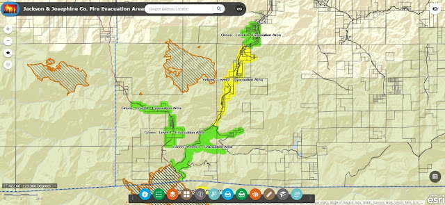
9-01-17 Chetco Bar Fire Daily Update
For a downloadable, emailable PDF of this update, click here.
Weather and Fire Behavior
Gusty, offshore winds will continue this morning. The forecast is for critical fire weather and the potential for extreme fire behavior due to low relative humidity and high temperatures with unstable atmospheric conditions. Significant perimeter growth and smoke column development are possible. Winds have the potential to carry embers seven tenths of a mile or more.
The National Weather Service issued a Red Flag Warning for critical fire weather Friday afternoon. There is an Excessive Heat Warning through Labor Day for temperatures significantly above normal.
Yesterday
The National Weather Service issued a Red Flag Warning for critical fire weather Friday afternoon. There is an Excessive Heat Warning through Labor Day for temperatures significantly above normal.
Yesterday
Active fire growth continued on the north, south and east perimeter. The fire continued eastward into areas previously during the 2002 Biscuit Fire. A smoke column developed on the southeast corner of the fire, rising up to 10,000 feet.
Aircraft dropped retardant and water along the southwest and western portions of the fire. Firefighters continued constructing direct and indirect line along the northwest and south flanks of the fire. Oregon State Fire Marshal task forces finished preparing structures in the Winchuck and Pistol River areas.
Today
On the west and northwest side of the fire, crews continue mop-up where fire has been contained while constructing direct and indirect lines northeast toward Snow Camp along the Pistol River. On the south end of the fire, below Emily Creek, crews are securing anchor points, using existing road networks to check fire growth. Tactical patrols on the southwest and western perimeter of the fire continue. Aircraft will assist with suppression work as visibility and weather allow.
On the eastern flank, firefighters are opening fire lines previously constructed during the 2002 Biscuit Fire. Crews will also assess structures along the Illinois River just east of the Kalmiopsis Wilderness.
Smoke production is expected to be significantly today. Light Northeast winds will drift smoke toward coastal areas into Gold Beach, Brookings and far South into NW California. Highway 101 and local roadways will see reduced visibility in these areas. A light sea breeze later today is expected to give some reprieve to coastal communities this afternoon. In the Agness, Cave Junction, and Grants Pass regions, heavy smoke impacts are expected to remain as smoke from several fires drain into these communities.
For a downloadable, emailable map of this update, click here.
 Evacuations
On the eastern flank, firefighters are opening fire lines previously constructed during the 2002 Biscuit Fire. Crews will also assess structures along the Illinois River just east of the Kalmiopsis Wilderness.
Smoke production is expected to be significantly today. Light Northeast winds will drift smoke toward coastal areas into Gold Beach, Brookings and far South into NW California. Highway 101 and local roadways will see reduced visibility in these areas. A light sea breeze later today is expected to give some reprieve to coastal communities this afternoon. In the Agness, Cave Junction, and Grants Pass regions, heavy smoke impacts are expected to remain as smoke from several fires drain into these communities.
For a downloadable, emailable map of this update, click here.
At 9:30 PM last night, Curry County Sheriff’s Office expanded the Level 2 Evacuation Order to include all areas along Winchuck River Road east of, and including, Peavine Ridge Road.
The Red Cross evacuation shelter is in Gold Beach at the Curry County Fairgrounds showcase building, 29392 Ellensburg Avenue. Tolowa Dee-ni’ Nation is also operating a shelter at The Xaa-wan’-k’wvt Village & Resort (old Ship Ashore) RV Park located at 12370 Highway 101 North in Smith River. Residents are encouraged to monitor the interactive evacuation map for changes: http://arcg.is/2vWQN2N
Closures
There are no closures on Highway 101 through Brookings. Local businesses, restaurants, and lodging establishments in Brookings and Harbor remain open for business. Several large wildfires are burning in southwest Oregon. Area closures have been implemented on the Rogue River – Siskiyou National Forest and BLM lands. Fire restrictions are in place: http://bit.ly/2erUN5B.
8-31-17 Chetco Bar Fire Daily Update
For a downloadable, emailable PDF of this update, click here.
Weather and Fire Behavior
Gusty, offshore winds will continue into Thursday night and Friday morning while relative humidity falls to very low levels. This will be followed by a prolonged hot and dry spell with poor relative humidity recovery.
The weekend weather forecast indicates critical fire weather and the potential for extreme fire behavior. Significant perimeter growth and smoke column development are possible. Winds have the potential to carry embers seven tenths of a mile.
Yesterday
Several areas of the fire were active on the north, south and east perimeter. The fire pushed eastward toward the Kalmiopsis Wilderness boundary into brushy vegetation north of Pearsoll Peak, in a portion of the area previously burned during the 2002 Biscuit Fire.
Favorable visibility provided opportunities for aerial support as firefighters completed significant work along the northwest and south flanks of the fire. Crews connected old dozer lines and strengthened fire lines directly along the perimeter of the west flank.
Favorable visibility provided opportunities for aerial support as firefighters completed significant work along the northwest and south flanks of the fire. Crews connected old dozer lines and strengthened fire lines directly along the perimeter of the west flank.
Today
Oregon State Fire Marshal task forces continue assessing structures in the Winchuck and Pistol River areas; preparing them for the possibility of fire being pushed into the area by the coming winds.
South of the fire, crews will work on constructing alternate lines and tying in the section where fire crossed Emily Creek. On the northwest perimeter, crews will bring line north to steer fire north and east. A contingent of firefighters will work from a remote camp near Agness; reducing travel time. On the eastern flank, firefighters are looking for opportunities to use fire line previously constructed during the 2002 Biscuit Fire while assessing structures along the Illinois River just east of the Wilderness.
South of the fire, crews will work on constructing alternate lines and tying in the section where fire crossed Emily Creek. On the northwest perimeter, crews will bring line north to steer fire north and east. A contingent of firefighters will work from a remote camp near Agness; reducing travel time. On the eastern flank, firefighters are looking for opportunities to use fire line previously constructed during the 2002 Biscuit Fire while assessing structures along the Illinois River just east of the Wilderness.
For a downloadable, emailable map of this update, click here.

Evacuations
Evacuations are in place in Curry County. They are being continually evaluated and adjusted to reflect developing conditions and resource availability.
Red Cross is moving its evacuation shelter in Gold Beach to the Curry County Fairgrounds showcase building at 29392 Ellensburg Avenue. Tolowa Dee-ni’ Nation is also operating a shelter at The Xaa-wan’-k’wvt Village & Resort (old Ship Ashore) RV Park located at 12370 Highway 101 North in Smith River.
Residents are encouraged to monitor the interactive evacuation map for changes: http://arcg.is/2vWQN2N
Area Closure Information
Several large wildfires are burning in southwest Oregon. Area closures have been implemented on the Rogue River – Siskyou National Forest and BLM lands. Fire restrictions are in place: http://bit.ly/2erUN5B.
8-30-17 Chetco Bar Fire Daily Update
For a downloadable, emailable PDF of this update, click here.
Weather and Fire Behavior
Fog developed overnight and is expected to cover most of the lower elevations of the fire this morning. The resulting cooler temperatures and improved humidity recovery should moderate fire behavior.
Later today, a strong high pressure front will move into the area. The resulting rise in temperatures, coupled with lower humidity and drying winds will increase fire activity. Fire could make its way to the tops of individual or groups of trees and potentially cast embers up to three-tenths of a mile, causing new ignitions (or spot fires). Temperatures will continue to rise this week and increases in fire behavior are anticipated.
Yesterday
The fire was active on the north, south and east perimeter. It pushed several miles to the northeast into the area previously burned by the 2002 Biscuit Fire.With improved visibility, each of the seven helicopters assigned to Chetco Bar was able to work the fire on Tuesday. On the southern flank, aircraft provided bucket drops in the Emily Creek area. Crews connected most of the contingency line on the southwest/west edge and have been searching for, and extinguishing, hot spots within 25 feet of the fireline. Indirect line construction occurred in the Pistol River area.Over the course of the incident, Oregon State Fire Marshal crews have assessed 1,222 structures, completed preparation work on 532 structures, and set more than 500 sprinklers.
Today
National Guard firefighters are joining the effort. They will extinguish hot spots that could potentially threaten containment lines between the fire and Brookings. Firefighters will take advantage of the moderated fire behavior early in the day to construct line in advance of the coming weather. This effort includes fireline construction in the areas at risk near Emily Creek and Hog Mountain. Aircraft will assist crews on the ground as visibility permits.
Evacuations
Level 2 and 3 evacuations are in place in Curry County. They are being continually evaluated and adjusted to reflect developing conditions and resource availability. Residents are encouraged to monitor the Evacuation Map for changes.
For a downloadable, emailable map of this update, click here.

Area Closure Information
Several large wildfires are burning in southwest Oregon. Area closures have been implemented on the Rogue River – Siskyou National Forest and BLM lands. Fire restrictions are in place. https://www.fs.usda.gov/alerts/rogue-siskiyou/alerts-noticesMore information: https://inciweb.nwcg.gov/incident/5385/#
Social Media Resources
Twitter: @RRSNF #ChetcoBarFireInciweb: https://inciweb.nwcg.gov/incident/5385/E‐mail: chetcobarfireinfo@gmail.comFacebook: https://www.facebook.com/chetcobarfire
8-29-17 Chetco Bar Fire Daily Update
For a downloadable, emailable PDF of this update, click here.
Weather and Fire Behavior
The trend of warm overnight temperatures and poor humidity recovery has set the Chetco Bar Fire up for another active fire day on Tuesday. Humidity levels are expected to begin climbing this afternoon. Ridgetop temperatures could reach the 90s. Fire burning in the tops of single trees and groups of trees is anticipated, with the potential for embers to fly up to 0.4 miles ahead of the fire. There is a high potential for large fire growth in areas where wind and terrain align.
Yesterday
While shading from smoke helped moderate fire activity Monday, it also presented challenges to aerial attack due to poor visibility. In the afternoon, smoke cleared enough that helicopters were able to work the northwest edge of the fire to support crews and heavy equipment. The most active burning occurred in the Emily Creek drainage, the East Fork of the Pistol River and along the eastern flank in the Kalimiopsis Wilderness.
Today
Reported 5% containment is on the fire’s west edge. Crews will continue scouting for and constructing primary and alternate containment lines and setting up hose-lays and water sources to be used in securing those lines. Constructed fireline includes a mix of line directly along the edge of the fire and some that is further from the fire’s edge in strategic locations. Firefighters will scout for and build direct and indirect lines along the north and east perimeter.
The risk to the Brookings area has diminished enough that larger structural engines are no longer needed. Chetco Bar Fire's Unified Command continues to utilize structural task forces that have the smaller engines. Oregon State Fire Marshal’s Office is working on a re-engagement plan with local fire departments and districts to be prepared with structural resources should conditions change. Additional structural resources will be demobilized as the threat to structures diminishes. Our mission to protect the community and surrounding area remains the same.
120 National Guard firefighters are coming to assist with mop up operations on the fire’s western perimeter.
Evacuations/Closure Information
Residences within parts of the Level 3 evacuation zone starting at the junction of Shady Lane and South Bank Chetco Road east, and including Freeman Rock and Salmon Run Golf Course have been reduced to a Level 2 Evacuation.
For a downloadable, emailable PDF of this map, click here.

For a downloadable, emailable PDF of this map, click here.

Monday, August 28, 2017
8-28-17 Evacuation Area Re-Entry Plan
For a downloadable, emailable PDF of this update, click here.
 Evacuation Area Re-entry Plan: “ADDITIONAL AREA”
All residences and businesses within the current Level 3 Evacuation zone starting at junction ofShady Lane and South Bank Chetco Road east to and including Freeman Rock and Salmon Run GolfCourse will be reduced to a Level 2 Evacuation. Residents and businesses will be allowed to return. The area also includes residents in the Campbell and Harbor Hills road area (see Level 2 Interactive Evacuation map).
All residents that live in this geographic area are asked to present their picture identification to CurryCounty Sherriff’s Office Staff to receive re-entry materials. Residents can pick up the re-entrymaterials from 11:00 am to 3:00 pm at Ray’s Market 906 Chetco Ave in Brookings, Oregon, or any ofthe re-entry points on South Bank Chetco Road.
One re-entry point has been established at Shady Lane and South Bank Chetco Road. Residents willpresent the materials received from the Sheriff’s Office at the established re-entry point.
Residents should remain prepared to evacuate in a moment’s notice in the event the evacuationlevels change and residents should not return any large animal’s home at this time.
Social Media ResourcesTwitter: @RRSNF #ChetcoBarFireInciweb: https://inciweb.nwcg.gov/incident/5385/
E‐mail: chetcobarfireinfo@gmail.comFacebook: https://www.facebook.com/chetcobarfire
8-28-17 Chetco Bar Fire Daily Update
For a downloadable, emailable PDF of this update, click here.
Weather and Fire Behavior
Critical fire weather conditions will continue today. Extreme fire behavior is anticipated. Dry and unstable conditions will lower humidity into the night and the unstable air could lead to more lift and ventilation over the fire. “This means people may see smoke columns forming,” said Noel Livingston, Incident Commander.
Yesterday
Chetco Bar Fire burned toward Hog Mountain to the northwest, Snow Camp Trailhead to the north and above Emily Creek to the south. As smoke cleared in the afternoon helicopters dropped water to slow fire progression; helping firefighters who were working to hold fire within containment lines and build additional direct and indirect containment line.
Firefighters and heavy equipment worked to connect existing roads and dozer lines south and west of the fire. Crews also continued to assess buffer zones around houses and clear brush as needed to protect homes. They have moved into the Pistol River and Winchuk areas.
Due to very active fire behavior on the southwest side of the fire, Curry County Sheriff’s Office expanded and heightened evacuation levels for some residents. Evacuation information is online at https://inciweb.nwcg.gov/incident/5385/.
With 80 degree temperatures and 20% relative humidity, Chetco Bar Fire burned actively overnight and crews worked spot fires on the west and south perimeter.
For a downloadable, emailable PDF of this map, click here.

For a downloadable, emailable PDF of this map, click here.

For a downloadable, emailable PDF of this map, click here.

For a downloadable, emailable PDF of this map, click here.

Today
Firefighters will use an infrared heat sensing device to locate, then suppress hot spots near the fire’s perimeter. As visibility and weather conditions allow, helicopters and aircraft will drop retardant and water to help slow the fire’s spread.
Crews will continue to construct direct dozer and handline, install and maintain hoselays, and scout for opportunities to extend containment lines north and south of the fire. Planned containment lines incorporate existing roads, sparsely vegetated ridgetops, and previously burned areas, including the 2002 Biscuit Fire. A structure protection group will continue to reduce fuels surroundinghomes, install and maintain hose lays.
Basecamps for Chetco Bar Fire will consolidate into a single location on Oceanview Drive.Evacuations/Closure Information: is online at https://inciweb.nwcg.gov/incident/article/5385/39102
8-28-17 Chetco Bar & Miller Complex Smoke Forecast
For a downloadable, emailable PDF of this update, click here.
Smoke
Very heavy to hazardous smoke impacts exist this morning as smoke from the Chetco Bar Fire has drained down canyon into local communities overnight. Visibility is significantly reduced on local roadways, including Highway 101. Coastal areas such as Gold Beach and Brookings-Harbor should see some reprieve in air quality this afternoon as a light sea breeze is expected to lift smoke. Agness and the Rogue River valley are expected to be Unhealthy to Very Unhealthy today. Cave Junction, Grants Pass, Ashland and surrounding communities are expected to see Unhealthy conditions through the day. In the regional scale, Southwesterly transport winds are expected to drift smoke produced from Chetco Bar and other active fires in the region again to the North toward Washington.


Very heavy to hazardous smoke impacts exist this morning as smoke from the Chetco Bar Fire has drained down canyon into local communities overnight. Visibility is significantly reduced on local roadways, including Highway 101. Coastal areas such as Gold Beach and Brookings-Harbor should see some reprieve in air quality this afternoon as a light sea breeze is expected to lift smoke. Agness and the Rogue River valley are expected to be Unhealthy to Very Unhealthy today. Cave Junction, Grants Pass, Ashland and surrounding communities are expected to see Unhealthy conditions through the day. In the regional scale, Southwesterly transport winds are expected to drift smoke produced from Chetco Bar and other active fires in the region again to the North toward Washington.


8-27-17 Chetco Bar Fire Updated Evacuation Order
Following the advice of the Chetco Bar Incident Management Team, and based on the current fire behavior, the Curry County Sheriff's Office has expanded the area under a Level 3 Evacuation Order to include areas along Carpenterville Road which lie north of Bosley Butte Road along Summit Ridge and north to Sundown Mountain.
A Level 3 Evacuation (GO!) means residents within this area should leave immediately. Danger to your area is current or imminent, and you should evacuate immediately. If you choose to ignore this advisement, you must understand that emergency services may not be available to assist you further. DO NOT delay leaving to gather any belongings or make efforts to protect your home.
The area under a Level 2 Evacuation Order has also expanded. All areas lying west of the level 3 Evacuation area are now in Level 2 Evacuation. Level 2 Evacuation (Be Ready) means residents within this are should be prepared to leave at a moment's notice. This level indicates there is significant danger to your area, and residents should either voluntarily relocate to a shelter or with family/friends outside of the affected area, or if choosing to remain, to be ready to evacuate at a moment's notice. Residents MAY have time to gather necessary items, but doing so is at their own risk.
The current Evacuation Map is available at: https://tinyurl.com/Aug27EvacUpdate
Brooking Police Department and the Oregon State Police are assisting the Curry County Sheriff's Office with making notifications to all affected residents within the identified evacuation areas.
Emergency Alerts:
Displaced residents may relocate to an emergency evacuation shelter at Riley Creek Elementary in Gold Beach 94350 6th St. Gold Beach, OR. (541)-600-6068. Travelers in campers and motels are asked to relocate elsewhere along the Oregon coast. Residents should make arrangements to move property and livestock. People with special health needs or other concerns should relocate during the warning.
The Sheriff's Office is turning back public traffic at Carpenterville Road west of Summit ridge below Burnt Hill. Travelers should avoid this area so that law enforcement and firefighting resources can respond to this emergency.
Residents in Curry County who have a landline will receive emergency notifications via that number. For residents who do not have a landline, or want to receive notifications on a cell phone need to sign up for Emergency Alerts. Curry County residents can sign up for Emergency Alerts on the Curry County website, or directly at:https://member.everbridge.net/index/892807736723773#/login.
8-27-17 Chetco Bar Community Meeting
For a downloadable, emailable PDF of this update, click here.

8-27-17 Chetco Bar Fire Daily Update
For a downloadable, emailable PDF of this update, click here.
Community Fire Briefing Tonight
Sunday, August 27, 2017 at 6:00 p.m.
Fire managers will provide an update about operations on the Chetco Bar Fire. This community fire briefing will be held at the Brookings-Harbor High School, 625 Pioneer Road, Brookings, Oregon.
Weather and Fire Behavior
A “Red Flag” warning has been issued for the Chetco Bar Fire area through Monday. The designation “Red Flag Warning” means “that critical fire weather conditions are either occurring now, or will shortly. Gusty winds, low humidity or dry, unstable conditions will create the potential,” according to the National Weather Service. For the Chetco Bar Fire area, the warning includes gusty, erratic winds, low relative humidity, particularly at higher elevations, and unstable atmospheric conditions which could lead to fire spreading through the tops of trees and the potential for plume dominated fire growth.
Smoke
Very heavy smoke impacts are expected today in regional communities surrounding the Chetco Bar Fire. For information about smoke and air quality in the Chetco Bar Fire area, visit: https://wildlandfiresmoke.net/outlooks/2017/ChetcoBar#Overview
Yesterday
 While there was little wind to influence fire growth, aerial support was hindered by poor visibility from the smoke staying in place over the fire area. Most active burning on the fire occurred on the northern portion, with the smoke column reaching 20,000 feet in the Johnson Butte area. There was also active fire in the Tin Cup area and around the East Fork of the Pistol River. Firefighters built and improved both direct and indirect fireline, scouted for opportunities for alternate firelines and improved roads to be used as firelines. They continued with structure protection efforts, including installing and maintaining hoselays, thinning and pulling flammable materials back from homes and structures.
Today
Crews will continue to strengthen and mop-up containment lines on the southwestern corner of the fire. To the north and south, crews are scouting for, and building direct and indirect fireline using existing roads, ridgetops that are sparsely vegetated and previously burned areas.
Structure protection efforts continue, focusing on reducing fuels around homes. The structure protection group is also installing hoselays and sprinkler systems.
Evacuations/Closure Information
The Curry County Sherriff’s Office decreased the evacuation level yesterday for residences in a level 3 evacuation zone starting at Henderson Road and Carpenterville Road north to Cape Ferrelo Road and east and west off Carpenterville Road, homeowners will be allowed to return to their homes. More information, including the re-entry process, is available at: https://inciweb.nwcg.gov/incident/article/5385/39102.
A map, showing Level I, II and III evacuation areas can be viewed at https://tinyurl.com/ChetcoBarEvac.
The Red Cross is operating a shelter at Riley Creek Elementary, 94350 6th St., Gold Beach, Oregon.
Quick Facts
Size
107,993 acres
Start Date
July 12, 2017
Cause
Lightning
Location
5 miles northeast of Brookings, Oregon
Incident Commanders
Melvin Thornton, CFPA
Scott Magers, Oregon State Fire Marshall
Noel Livingston, PNW Team 3
Resources
Crews: 42
Engines: 105
Helicopters: 15
Dozers: 26
Water Tenders: 31
Total Personnel: 1,662
Social Media Resources
Blog: ChetcoBarFire.wordpress.com
Inciweb: https://inciweb.nwcg.gov/incident/5385/
Facebook: Chetco Bar Fire
Twitter: @RRSNF #ChetcoBarFire
8-27-17 Smoke Forecasts for Chetco Bar, Miller Complex and High Cascades Complex
8-27-17 Chetco Bar & Miller Complex Smoke Forecast
For a downloadable, emailable PDF of this update, click here.
Smoke
Very heavy smoke impacts are expected today in regional communities surrounding the Chetco Bar Fire. Coastal areas such as Gold Beach and Brookings-Harbor will see the majority of impacts along with Agness and the Rogue River Valley. In these areas expect Unhealthy and Very Unhealthy air quality conditions along with reduced visibility along Highway 101. Cave Junction, Grants Pass, Ashland and surrounding communities are also expected to see Unhealthy conditions from Chetco Bar and other fires in the region. Not only is smoke produced from the active fires draining into local valleys, smoke is also drifting into the Willamette Valley to Portland with light southwesterly winds.


 |
| A view at the smoke settling in near Brookings-Harbor as one of several structural protection engines heads to their next destination on August 26, 2017 |
Chetco Bar Fire: Evacuation Area Re-Entry Plan
For a downloadable, emailable PDF of this update, click here.
Evacuation Area Re-entry Plan: "ADDITIONAL AREA"
All residences within the fire affected area currently in a level 3 evacuation zone starting at Henderson Road and Carpenterville Road north to Cape Ferrelo Road and east and west off Carpenterville Road will be allowed to return to their homes.
All residents that live in this geographic area are asked to present their picture identification to Curry County Sherriff's Office Staff members to receive re-entry materials. Residents can pick up the reentry materials from 3 pm to 6 pm at Ray's Market 906 Chetco Ave in Brookings, Oregon, or any of the re-entry points on Carpenterville Road.
Two re-entry points have been established at Carpenterville at Rainbow Rock Road or Pistol
River/Hwy 101. Residents will present the materials received from the Sheriff's office at established re-entry points.
Residents should remain prepared to evacuate in a moment's notice in the event the evacuation levels change and residents should not return any large animal's home at this time.
(An updated area evacuation map will be released shortly.)
Social Media Resources:
Twitter: @RRSNF #ChetcoBarFire
Inciweb: https://inciweb.nwcg.gov/incident/5385/
Smoke Blog: http://oregonsmoke.blogspot.com/
E-mail: chetcobarfireinfo@gmail.com
Facebook: https://www.facebook.com/R6RRSNF/
08-26-17 Chetco Bar Fire Update
For a downloadable, emailable PDF of this update, click here

Weather and fire behavior: The National Weather Service issued a Red Flag Warning for the area of the Chetco Bar Fire through 9 p.m. Saturday evening along with a Fire Weather Watch through Sunday. There will be a drying trend over the fire area with increased temperatures and lower humidity. Winds along ridgetops are predicted to gust 20 mph out of the northeast. Vegetation will continue to dry out, increasing susceptibility to ignition and subsequent fire spread.
As the winds shift out of the northeast, smoke conditions are expected to be hazy in the Brookings area. These conditions have the possibility of impacting Highway 101. For more information: https://wildlandfiresmoke.net/outlooks/2017/ChetcoBar#Overview
Yesterday: The predicted gusty northeast winds did not occur over the fire area yesterday. Crews took advantage of this opportunity and continued their progress along the southwestern and western edges of the fire.
Aviation resources took advantage of opportunities when smoke cleared and visibility improved to use retardant and water along containment lines to check fire spread. Throughout the night, fire crews worked to build direct and indirect containment lines, prepare structures and patrol fire activity near homes and scout contingency lines.
Today: The thermal trough over the area will contribute to very active fire behavior late into the evening on Saturday and early Sunday morning. During short crown runs, the potential exists to cast embers up to half a mile ahead of the fire.
Along the west and southwest perimeter, firefighters are working to construct additional fireline and to install hoselays that will help to hold fire within containment lines. They will look for opportunities near the northwest and southern perimeter to construct primary and alternate containment lines.
Quick Facts
Incident Summary
Size:105,518 acres Start Date:July 12, 2017 Cause: Lightning Location: 5 miles northeast of Brookings, Oregon Incident Commanders: Melvin Thornton, CFPA:Scott Magers, Oregon State Fire Marshall, Noel Livingston, PNW Team 3
Resources on the Fire
Crews: 34
Engines: 56
Helicopters: 8
Dozers: 19
Water Tenders: 31
Total Personnel: 1,612
Helpful Links
Interactive Fire and Evacuation Map: http://arcg.is/2vWQN2N
Firewise Communities: http://www.firewise.org/?sso=0
Curry Alert (Reverse 911): https://member.everbridge.net/index/892807736723773#/login
Establishment of an additional helibase will enable aerial support to continue when poor visibility in existing locations would otherwise hinder that support.
Evacuations/Closure Information: Level 1, 2, and 3 Evacuation Levels remain in effect for the Chetco Bar Fire. A map of the evacuation area can be viewed at http://tinyurl.com/Aug24-EvacUpdateMap.
Residents can sign up for Curry County emergency alert system at http://tinyurl.com/CurryReverse911. The Red Cross is operating a shelter at Riley Creek Elementary, 94350 6th St. in Gold Beach, OR.
Local residents are encouraged to review the evacuation levels of the Ready, Set, Go Program at http://tinyurl.com/RdySetGo.
Additional Chetco Bar Fire Information
Blog: ChetcoBarFire.wordpress.com
https://inciweb.nwcg.gov/incident/5385/
Facebook: Rogue-River Siskiyou