
Miller Complex Fire Update
September 29, 2017 – 9:00 a.m.
Acres: 36,654
Percent Contained:
80%
Start Date: August 14, 2017
Cause: Lightning
Total Personnel: 177
Location: Private land and federal
land on the Rogue River-Siskiyou National Forest 20 miles west of Ashland, OR.
Fire Information: 541-838-0770, Email address: millercomplex2017@gmail.com
Over
the last two days, the Abney Fire grew by about 400 acres. A smoke column was
visible yesterday from the Dutch Creek area. Due to steep slopes, poor access,
and heavy fuel loading ground crews were not committed to build direct
containment lines. A heavy helicopter dropped water buckets throughout the
shift to slow fire growth. Overall, fire managers view this as a beneficial
piece of natural fire that burned as they expected well within established
containment lines.
Cooler
weather is forecasted through the weekend, bringing lower temperatures and
higher humidity that should lead to a decrease in fire activity. Light to
moderate rain is expected over the fire area Friday morning through afternoon,
although wetting rain is unlikely. Moderate winds out of the north will be the
main concern through Friday evening and could promote some fire growth.
Firefighters and heavy helicopters are available to take action as needed.
Crews
continue to monitor and patrol hand lines on the Burnt Peak and Creedence fires.
Repair work, including brushing and chipping of roads, continues across the
complex in order to naturalize areas impacted by fire suppression tactics.
Closures: An
area closure remains in place for the Miller Complex. Roads bordering the Burnt
Creek and Creedence fires remain closed. Although Carberry Creek Road has been
opened, spur roads leading to the burn area also remain closed. Forest
officials and fire managers ask that individuals adhere to the area closure still
in effect for public and firefighter safety. Forest visitors are cautioned to
remain alert and drive with care when near fire areas as crews will still be
working in these zones.
For
more information on the area closure visit the Rogue River-Siskiyou National
Forest closure page at https://www.fs.usda.gov/alerts/rogue-siskiyou/alerts-notices.
The
Bureau of Land Management has closed the Grayback Mountain Trailhead. For Klamath
National Forest closures see https://www.fs.usda.gov/alerts/klamath/alerts-notices.
Miller Complex
Information Websites:
Inciweb - https://inciweb.nwcg.gov/incident/5514/
Miller Complex Abney
Fire, south of the Pacific Crest Trail (PCT) - https://inciweb.nwcg.gov/incident/5511/
ODFW Web
Information about hunting and closures- https://www.dfw.state.or.us/resources/hunting/fire.asp
For all wildfires
on the Rogue River-Siskiyou NF, Joint Information Center Blog - http://swojic.blogspot.com/

Infrared Map of Abney Fire

Total Miller Complex Map

Miller Complex Fire Update
September 28, 2017 – 9:00 a.m.
Today will bring more warm and dry weather over the fire and
a visible smoke column is expected in the area as fire activity increases in
response to these trends. Crews are engaged along the active portions and are
providing real time observations on fire behavior and progression. The fire is
well within designated containment lines that include road systems and natural
barriers.
Today will likely be the last day of active burning as a
cold front will arrive tomorrow and bring more fall-like weather over the
weekend. Some light rain is expected on Friday but wetting rain is unlikely.
The Creedence and Burnt Peak fires are each at 95%
containment and repair work continues on hand and dozer lines no longer in use.
Overall containment on the Miller Complex has increased to 80% and will likely
remain there until a season ending weather event.
Closures: An area closure remains in place for the Miller Complex. Roads bordering the Burnt Creek and Creedence fires remain closed. Although Carberry Creek Road has been opened, spur roads leading to the burn area also remain closed.
Forest officials and fire managers ask that individuals
adhere to the area closure still in effect for public and firefighter safety.
Forest visitors are cautioned to remain alert and drive with care when near
fire areas as crews will still be working in these zones. For more information
on the area closure visit the Rogue River-Siskiyou National Forest closure page
at https://www.fs.usda.gov/alerts/rogue-siskiyou/alerts-notices.
The Bureau of Land Management has closed the Grayback
Mountain Trailhead. For Klamath National Forest closures see https://www.fs.usda.gov/alerts/klamath/alerts-notices.
Miller Complex Information Websites:
Inciweb - https://inciweb.nwcg.gov/incident/5514/
Miller Complex Abney Fire, south of the Pacific Crest
Trail (PCT) - https://inciweb.nwcg.gov/incident/5511/
ODFW Web Information about hunting and closures- https://www.dfw.state.or.us/resources/hunting/fire.asp
For all wildfires on the Rogue River-Siskiyou NF, Joint
Information Center Blog -http://swojic.blogspot.com/

Miller Complex Fire Update
September 27, 2017 – 9:00 a.m.
Acres: 36,496
Percent Contained: 75%
Start Date: August 14, 2017
Cause: Lightning
Total Personnel: 193
Location: Private land and federal land on the Rogue River-Siskiyou National Forest 20 miles west of Ashland, OR.
Fire Information: 541-838-0770, Email address: millercomplex2017@gmail.com
Over the next few days the Abney Fire will continue to respond to warming and drying trends as a thermal trough moves over the area. Warmer temperatures are drying fuels out, producing additional smoke from the incident. Firefighters are not able to access the steep, rough terrain on the east flank of the fire.
Isolated areas continue to burn, funneling smoke down Elliot Creek and West Fork of Dutch Creek. A morning inversion then traps the smoke, not allowing it to rise. This process is occurring between the hours of 8:00 a.m. to 12:00 p.m. and by midday the ground is heating up enough to cause the smoke to lift out of the inversion and disperse. With higher temperatures and lower humidity recoveries at night, the inversion is expected to last a few more days until predicted weather patterns change over the weekend.
Fire crews continue to monitor and patrol the Creedence and Burnt Creek fires, with a focus on repair work and removal of equipment, pumps, and hoses. Containment lines no longer in use have been reseeded with native flora, in coordination with district botanists and resource advisors. Crews on the Abney Fire are also focusing on road improvement work and pulling back berms on hand lines and dozer lines. Fire managers do expect an increase in fire behavior on the east flank of the Abney Fire, with geographic features and road systems serving as containment lines.
Closures: The Miller Complex area closure has been reduced. Roads bordering the Burnt Creek and Creedence fires remain closed. Although Carberry Creek Road has been opened, spur roads leading to the burn area also remain closed. Forest officials and fire managers ask that individuals adhere to the area closure still in effect for public and firefighter safety. Forest visitors are cautioned to remain alert and drive with care when near fire areas as crews will still be working in these zones. For a more precise, technical definition of these closures, please see Forest Order Number 06-10-22-17-37, or visit the Rogue River-Siskiyou National Forest closure page at https://www.fs.usda.gov/alerts/rogue-siskiyou/alerts-notices. The Bureau of Land Management has closed the Grayback Mountain Trailhead. For Klamath National Forest closures see https://www.fs.usda.gov/alerts/klamath/alerts-notices.
Miller Complex Information Websites:
Inciweb - https://inciweb.nwcg.gov/incident/5514/
Facebook - https://www.facebook.com/MillerComplexFires/ and https://facebook/R6RRSNF
Miller Complex Abney Fire, south of the Pacific Crest Trail (PCT) - https://inciweb.nwcg.gov/incident/5511/
ODFW Web Information about hunting and closures- https://www.dfw.state.or.us/resources/hunting/fire.asp
For all wildfires on the Rogue River-Siskiyou NF, Joint Information Center Blog - http://swojic.blogspot.com/

Firefighter performing suppression repair work
Posted on: 09/26/17 10:49 am

Infrared Map
September 26, 2017 – 9:00 a.m.
Miller Complex Fire Update
Acres: 36,496
Percent
Contained: 75%
Start
Date: August
14, 2017
Cause: Lightning
Total Personnel: 189
Location:
Private
land and federal land on the Rogue River-Siskiyou National Forest 20 miles west
of Ashland, OR.
Containment
on the Miller Complex has increased to 75%. During a reconnaissance flight
yesterday the Incident Commander observed ground fire moving at a low intensity
near Elliot and Dutch Creak. Warmer and drier weather in conjunction with
overnight winds are lowering overall humidity levels. Fire behavior and smoke
production are increasing with the changing weather as anticipated. Crews are
reinforcing and patrolling primary, alternate and contingency lines along this
more active flank of the Abney Fire.
Yesterday
two medical scenarios were carried out on the Abney Fire. Crews had the
opportunity to simulate a fire line medical response, which included gathering
information on the injured individual, providing dispatch with the necessary information
and securing the patient on a backboard before carrying them out. Medics
assigned to the incident gave a presentation on the latest medical equipment
relevant to wildland firefighters. The medical scenarios tested communication
procedures and refreshed the participants on proper patient care and extraction
techniques.
Operational
objectives remain the same on the Miller Complex with a focus on repair work.
Firefighters will also monitor and patrol of fire activity. Rogue
River-Siskiyou National Forest Officials and resource advisors are pleased with
the repair work completed on the fires so far.
Closures:
The
Miller Complex area closure has been reduced. Forest and fire managers ask that
the public respect the area closure still in effect for the sake of public and
firefighter safety. The public is cautioned to remain alert and drive with care
when near fire areas as crews will still be working in these zones. For a more
precise, technical definition of these closures, please see Forest Order Number
06-10-22-17-37, or visit the Rogue River-Siskiyou National Forest closure page
at https://www.fs.usda.gov/alerts/rogue-siskiyou/alerts-notices. The
Bureau of Land Management has closed the Grayback Mountain Trailhead. For Klamath
National Forest closures see https://www.fs.usda.gov/alerts/klamath/alerts-notices.
Miller
Complex Information Websites:
Miller
Complex Abney Fire, south of the Pacific Crest Trail (PCT) - https://inciweb.nwcg.gov/incident/5511/
ODFW Web
Information about hunting and closures- https://www.dfw.state.or.us/resources/hunting/fire.asp
For all
wildfires on the Rogue River-Siskiyou NF, Joint Information Center Blog - http://swojic.blogspot.com/
Miller Complex Fire Update
September 25, 2017 – 9:00 a.m.
Acres: 36,496
Percent Contained: 70%
Start Date: August 14, 2017
Cause: Lightning
Total Personnel: 167
Location: Private land and federal land on the Rogue River-Siskiyou National Forest 20 miles southwest of Medford, OR.
Fire Information: 541-838-0770, Email address: millercomplex2017@gmail.com
Rogue River-Siskiyou National Forest Officials have reduced the Miller Complex Area Closure
The reduced area closure takes effect today, September 25, 2017. Due to the repair progress completed on both the Burnt Peak and Creedence fires, officials feel comfortable allowing recreationists and hunters back into the area. The Abney Fire area will remain closed for the time being as a safety precaution. For a more precise, technical definition of these closures, please see Forest Order Number 06-10-22-17-37, or visit the Rogue River-Siskiyou National Forest closure page at https://www.fs.usda.gov/alerts/rogue-siskiyou/alerts-notices.
Forest and fire managers ask that the public respect the area closure still in effect for the sake of public and firefighter safety. People driving or walking inside fire perimeters is a safety concern. When driving near fire areas, the public is cautioned to remain alert and drive with care as crews are likely to still be working in the area. With hunting season underway, it is particularly important that participants are informed on local area closures, fire restrictions, camping regulations and hazards found in recently-burned areas. The Oregon Department of Fish and Wildlife has a comprehensive list of informative links for hunters that can be found at http://www.dfw.state.or.us/resources/hunting/fire.asp.
Fire personnel are planting seeds in areas disturbed by fire suppression tactics primarily where dozers were used. Planting seeds will promote regeneration in these impacted areas. Repair operations including water bar construction, chipping of woody debris, road improvement and backhauling of equipment have all been successful across the complex thus far, and will continue today.
The Elliot and Dutch Creak areas of the Abney Fire are the most active zone on the Miller Complex. Fire behavior is low, moving slowly across the forest floor consuming needle cast, leaf litter, and small scale twigs and brush. Visible smoke can be expected until a season ending event, such as snow. Weather is forecasted to become warmer and dryer as the week progresses. Firefighters have been collecting fuel samples from the field and testing moisture levels. Monitoring moisture levels in forest materials will allow fire managers to better estimate upcoming fire behavior, and plan accordingly.
Closures:
The Rogue River-Siskiyou National Forest has a closure area in place https://www.fs.usda.gov/alerts/rogue-siskiyou/alerts-notices. The Bureau of Land Management has closed the Grayback Mountain Trailhead. For Klamath National Forest closures see https://www.fs.usda.gov/alerts/klamath/alerts-notices.
Miller Complex Information Websites:
Inciweb - https://inciweb.nwcg.gov/incident/5514/
Facebook - https://www.facebook.com/MillerComplexFires/ and https://facebook/R6RRSNF
Miller Complex Abney Fire, south of the Pacific Crest Trail (PCT) - https://inciweb.nwcg.gov/incident/5511/
For all wildfires on the Rogue River-Siskiyou NF, Joint Information Center Blog - http://swojic.blogspot.com/
 Miller Complex Fire Update
September 24, 2017 – 9:00 a.m.
Acres: 36,496
Percent
Contained: 70%
Start
Date: August
14, 2017
Cause: Lightning
Total Personnel: 171
Location:
Private
land and federal land on the Rogue River-Siskiyou National Forest 20 miles
southwest of Medford, OR.
The
Rogue River-Siskiyou National Forest and Type 3 IMT maintain public and
firefighter safety as their top priority on the Miller Complex. Repair work
continues and active fire is being monitored. Steep slopes, rugged terrain and heavy
fuel loading all pose challenges for firefighters. All of these hazardous
factors are taken into account as fire managers assess risks involved with
operational tactics.
As
a warming and drying trend moves into the region, increased fire activity and
visible smoke can be expected. Today will be sunny with temperatures around
70-75. Easterly winds overnight will cause humidity to drop. As humidity drops,
fuels on the ground will become dryer leading to increased fire behavior.
In
preparation for the upcoming weather shift, daily operations on the Abney Fire
will focus on thinning and brushing work along Forest Road 1050 and the
accompanying spur roads 140 and 160. Fuels reduction along these roads will
further improve the containment lines in place to protect private property
along the fire’s eastern flank. Fire activity is being monitored with aircraft
and ground personnel.
Today
on the Creedence Fire, crews will continue chipping woody debris, constructing
water bars, covering of hand and dozer line, backhauling of equipment that is no
longer needed and assessment of additional repair needs. Resource advisors have
approved the repair work completed on the Burnt Peak Fire. Crews will patrol
both incidents to ensure fire remains within containment lines. The Knox Fire
is being monitored by air and has shown minimal fire activity.
Closures:
The
Rogue River-Siskiyou National Forest has a closure area in place https://www.fs.usda.gov/alerts/rogue-siskiyou/alerts-notices. The
Bureau of Land Management has closed the Grayback Mountain Trailhead. For Klamath
National Forest closures see https://www.fs.usda.gov/alerts/klamath/alerts-notices. Forest
officials are discussing a reduced closure area.
Miller
Complex Information Websites:
Miller
Complex Abney Fire, south of the Pacific Crest Trail (PCT) - https://inciweb.nwcg.gov/incident/5511/
For all
wildfires on the Rogue River-Siskiyou NF, Joint Information Center Blog - http://swojic.blogspot.com/


09-23-17 Miller Complex Daily Update
A Type 3 Incident Management Team (IMT) assumed management responsibilities for the Miller Complex Friday
morning. Fire managers evaluate personnel safety and exposure when developing suppression strategies. The Rogue River-Siskiyou National Forest features heavy fuel loading, steep slopes, rugged terrain and difficult access, all of which influence operational decisions.
Operations Section Chief Jason Hutchinson shared the following statement, “As a team, we are determining the safest, most efficient operational plan. All of our strategies and tactics are based terrain, hazards, weather conditions and fire behavior. Firefighter safety is paramount.”
Fire activity was limited to creeping and smoldering yesterday, burning primarily in heavy downed logs and surface fuels. Today’s fire behavior will be very similar. As we move towards warmer and drier conditions, an increase in fire activity is expected in the Elliot and Dutch creek drainages. High temperatures will be in the mid to upper 60s today and humidity
will drop to around 35 to 40 percent.
Yesterday’s clear skies allowed for aerial observations and a thorough assessment of fire behavior and identification of areas for direct and indirect containment lines. Fire managers will utilize natural barriers and road systems in the Elliot and Dutch creek areas to limit fire growth.
The east flank of the Abney Fire remains the highest priority in the complex
due to the proximity to private land and the amount of uncontrolled fire edge. Crews will continue with fuels reduction operations along road systems to improve primary, alternate and contingency lines.
The Knox Fire, located in the Red Buttes Wilderness, displayed minimal fire activity is being monitored by air. Firefighters completed the majority of work on the Burnt Peak Fire and will patrol the wildfire to ensure that it remains within established containment lines. On the Creedence Fire, crews will remove portable water tanks, hoses and pumps from the fireline and repair resource damage from fire suppression activities. These repair measures include: building water bars, covering hand lines and dozer lines, and chipping woody debris.
Closures: The Rogue River-Siskiyou National Forest has a closure area in place https://www.fs.usda.gov/alerts/roguesiskiyou/ alerts-notices. The Bureau of Land Management has closed the Grayback Mountain Trailhead.
For Klamath National Forest closures see https://www.fs.usda.gov/alerts/klamath/alerts-notices.
Miller Complex Information Websites:
Inciweb - https://inciweb.nwcg.gov/incident/5514/#
Facebook - https://www.facebook.com/MillerComplexFires/ and https://facebook/R6RRSNF
Miller Complex Abney Fire, south of the Pacific Crest Trail (PCT) - https://inciweb.nwcg.gov/incident/5511/
For all wildfires on the Rogue River-Siskiyou NF, Joint Information Center Blog - http://swojic.blogspot.com/
09-22-17 Miller Complex Daily Update
Acres: 36,496
Percent Contained: 70%
Start Date: August 14, 2017
Cause: Lightning
Total Personnel: 284
Location: Private land and federal land on the Rogue River-Siskiyou National Forest 20 miles southwest of Medford, OR.
Fire Information: 541-838-0770 (new phone number), Email address:millercomplex2017@gmail.com
A Type 3 Incident Management Team (IMT) assumed management responsibilities for the Miller Complex at 6:00 a.m. today. The Type 3 IMT remains committed to public and firefighter safety as the top priority. Steep slopes and rugged terrain make evacuating an injured firefighter extremely difficult, and fire management decisions and strategies are based on this and other risk-management factors. “We continue to assess opportunities for indirect and direct control lines as the terrain and fire activity allow,” said Incident Commander Trainee Jimmer Hunt. “As with any suppression activity, we are weighing probability of success of the operation against firefighter exposure and determining the best course of action moving forward.”
The fire area received significantly less rainfall than other areas of the Rogue River-Siskiyou National Forest. Minimal fire activity occurred yesterday, and fire behavior will likely be reduced to smoldering and creeping today. A transition towards warmer and drier conditions starts today with temperatures expected to be 5 to 10 degrees above normal by early next week.
Expect to see increased fire activity in the Middle Fork Applegate River drainage and Dutch Creek area. With a warmer weather building over the fire area, fire managers will identify opportunities to limit fire spread on the Abney Fire. A combination of natural barriers, road systems and containment lines will be implemented in the Dutch Creek area on the eastern flank and in the Slick Rock and Bear Wallow areas to the west. In the Joe Bar area, the fire has now backed down to the creek as anticipated.
The warning to evacuate was lifted September 19 and residents were notified.
Firefighters will patrol the Burnt Peak Fire to ensure that it remains within established containment lines. On the Creedence Fire, crews and equipment will be utilized to backhaul or remove equipment no longer needed and also repair the impacts from the fire suppression effort. These repair measures include: building water bars, covering hand lines and dozer lines and chipping woody debris.
Closures: The Rogue River-Siskiyou National Forest has a closure area in place https://www.fs.usda.gov/alerts/roguesiskiyou/ alerts-notices. The Bureau of Land Management has closed the Grayback Mountain Trailhead. For Klamath National Forest closures see https://www.fs.usda.gov/alerts/klamath/alerts-notices.
Miller Complex Information Websites: Inciweb - https://inciweb.nwcg.gov/incident/5514/#
Facebook - https://www.facebook.com/MillerComplexFires/ and https://facebook/R6RRSNF
Miller Complex Abney Fire, south of the Pacific Crest Trail (PCT) - https://inciweb.nwcg.gov/incident/5511/
For all wildfires on the Rogue River-Siskiyou NF, Joint Information Center Blog - http://swojic.blogspot.com/
Clearing Fuels Along the Fireline


Miller
Complex Fire Update
Sept. 21, 2017
Northwest
Incident Management Team 9 (NW9), Brian Goff, Incident Commander
Information
Phone: 541-899-5302 Email: MillerComplex2017@gmail.com
Complex Size: 36,302 acres Containment:
65% Personnel: 225
Tomorrow (Friday, Sept. 22),
Northwest Incident Management Team 9 (NW9) turns over management of the Miller
Complex fires to a Type 3 command structure, signaling a reduction in the
incident’s complexity. Today, the Type 3
team will work with NW 9. The Type 3
team will continue operations at the current incident command post location. Some of the management and support staff from
NW9 will continue with the Type 3 team, along with approximately 200
firefighters. Personnel are expected to remain
on the complex until a season-ending event, such as sufficient rain/snow,
arrives to stop fire activity.
Current Situation: Firefighter and public safety are the top
priority.
The Miller Complex remains at 65%
completed overall. The complex includes the portion of the Abney Fire that is
north of the Pacific Crest Trail. The
east and west flanks of the Abney Fire make up about 35% of the complex
perimeter. Those east and west flanks
are not contained today, but they pose little threat to high values such as
infrastructure and private lands.
On the west flank, fire movement
is restricted to the Red Buttes Wilderness.
Fire is compatible with wilderness management, and numerous natural
barriers exist within the wilderness to limit fire spread.
On the east flank of Abney, firefighters
have constructed fireline to the north and east of the open fire
perimeter. The ridge that includes the
Pacific Crest Trail will be the containment feature to the south. Those lines will contain the fire and prevent
it from entering private lands.
Probabilities are high that
season-ending rain/snow will occur before the fire reaches the containment
boundary. However, if future weather
conditions allow the fire to spread toward those boundaries, a team will be in
place to implement timely suppression actions and hold the fire within the
identified containment area.
Today’s weather/fire behavior:
Cloudy, cool, damp weather prevailed over the incident yesterday. Measurable rainfall varied widely from wet to
dry, west to east, with 1.53 inches of rain northwest of the Creedence Fire, 0.36
inches at Carberry, and 0.2 inches at Squaw Peak to the east.
Today will be cool, yet warmer
than yesterday, damp and showery. With
the wet, cool and windy conditions, firefighters will adjust to changing
weather conditions by watching for snags, burnt debris, washouts and slippery
surfaces. Little fire activity is
anticipated due to the wetting rain. Fire behavior is anticipated to be low. Drier
and warmer weather starts Friday and will continue into next week.
Miller Complex Abney Fire, south
of the Pacific Crest Trail (PCT): https://inciweb.nwcg.gov/incident/5511/.
Closures: The Rogue River-Siskiyou National Forest closed
areas https://www.fs.usda.gov/alerts/rogue-siskiyou/alerts-notices. The Bureau of
Land Management has closed the Grayback Mountain Trailhead. Klamath National Forest closures see https://www.fs.usda.gov/alerts/klamath/alerts-notices.
Website: https://inciweb.nwcg.gov/incident/5514/# Joint Information Center Blog: http://swojic.blogspot.com/
09-20-17 Miller Complex Daily Update
On Friday, NW IMT 9 will be turning over management of the Miller Complex fires to a Type 3 command structure, signaling a reduction in the incident’s complexity. The Type 3 team will patrol established containment lines, rehabilitate those lines as needed, and monitor areas of the fire where natural features provide containment. These may include areas of less dense vegetation and significant rock band formations.
The Type 3 team inherits the incident command post location. Approximately 200 firefighters will continue to be assigned to the Miller Complex. Personnel are expected to remain on the fire until a season-ending event, such as sufficient snow, to stop fire activity.
The Miller Complex is 65% contained overall. Firefighter and public safety remain a top priority. Over the days during wet conditions, firefighters will focus on accomplishing work safely, adjusting to changing weather and conditions by being mindful of snags blown down by wind, the potential for movement of burnt debris, washouts and slippery surfaces.
Today, little fire activity is anticipated due to the wetting rain. Fire behavior is anticipated to be low for the next several days. Firefighters will repair hand lines on the Creedence Fire and continue chipping work on the west flank of the Abney Fire. Chipping the woody material previous cut during suppression activities creates mulch that is then spread to help contain erosion that could occur in heavy rain. Other activities on the Abney Fire include patrols in on the north flank as far east as Seattle Bar; as well as backhaul of equipment -- such as hose -- on the fire’s east flank.
In the Joe Bar area, the fire has now backed down to the creek as anticipated. The warning to evacuate was lifted September 19 and residents were notified.
Fire managers are actively consulting with local district and resource advisors on fire repair opportunities, such as evaluating the need for water bars in areas where suppression activities have taken place. Water bars help prevent erosion and improve soil stability in areas that lack vegetation due to burning. They are typically installed in hand and dozer lines.
Fire Statistics: Start Date: August 14, 2017 Cause: Lightning Complex Size: 36,302 acres
Containment: 65% Personnel: 338


09-19-17 Miller Complex Daily Update
Evacuations: The evacuation warning for the Joe Bar community has been lifted. There are no evacuations on the Miller Complex.
Weather: Rains brought moisture to most of the Miller Complex over the last two days, with the largest amounts on the west side of the Abney Fire. Forecasts show more widespread, significant rain coming tonight and into Wednesday with a quarter to a half inch over most of the complex and up to one inch over the western edge. Winds will increase with gusts on the higher peaks of up to 40 mph.
The rain has decreased fire behavior, but this system will not put the fire out. Fire behavior will diminish while the front moves through, with the potential for the fire to become active if conditions dry out in the future. The public will likely see smoke from the interior of these fires until a season-ending weather event occurs.
Current Situation: Containment on Miller Complex is 65% overall. Firefighter and public safety remain top priority on the complex. Over the next few days firefighters will focus on accomplishing work safely under changing conditions. Rain and wind will make for slippery conditions and unstable grounds that could lead to washouts.
The chipping operation on the Creedence Fire is complete and will be complete on the Burnt Peak Fire today. Firefighters will continue to patrol these fires daily.
The west flank of the Abney Fire continues to be active near the Middle Fork of the Applegate River and below Whiskey Ridge. Fire managers will use the Red Buttes Wilderness as a containment area. This wilderness has natural barriers such as rock bands and minimal vegetation, features that confine fire. Although there could be some fire activity in these rugged areas, the likelihood of the fire threatening private values is low.
On the east flank, there is fire in the West Fork of Dutch Creek. It has traveled to the top of the ridge above the creek. Fire managers have designed a plan to confine the fire to that area, protecting private industrial timber land to the east and south. Eventually, changes in the weather will put the fire out.
Fire managers are working with local district and resource advisors on suppression repair opportunities. Firefighters are installing waterbars to help prevent erosion of lines constructed as part of the suppression action. Waterbars are typically installed in hand and dozer lines.
Over the next few days the Miller Complex will downsize personnel and prepare to transition into a Type 3 incident management team toward the end of the week.
Miller Complex Abney Fire, south of the Pacific Crest Trail (PCT): https://inciweb.nwcg.gov/incident/5511/.
Closures: The Rogue River-Siskiyou National Forest closed areas https://www.fs.usda.gov/alerts/rogue-siskiyou/alerts-notices.
The Bureau of Land Management has closed the Grayback Mountain Trailhead.
Klamath National Forest closures see https://www.fs.usda.gov/alerts/klamath/alerts-notices.
Website: https://inciweb.nwcg.gov/incident/5514/# Joint Information Center Blog: http://swojic.blogspot.com/
Facebook: https://www.facebook.com/MillerComplexFires/ or https://facebook/R6RRSNF

09-18-17 Miller Complex Daily Update
Current Situation: A front that arrived late last night is bringing with
it highly anticipated humidity and cooler temperatures to the fires within the
Miller Complex. Variable rains are expected throughout the day with an
increased chance of heavier rains Tuesday into Wednesday.
Although the arrival of the
cool front is a positive development, the moisture will not extinguish the
fires. Instead, fire behavior will diminish while the front moves through the
fire complex with the potential for the fire to become active again if
conditions dry out in the future. The public can still expect to see smoke from
the interior of these fires until a season-ending weather event occurs.
The Miller Complex remains at
59% containment overall and firefighters continue to meet objectives and patrol
lines. Firefighter and public safety remain top priority and over the next few
days firefighters will focus on accomplishing work safely to adjust to the
changing weather and conditions by being mindful of the potential for movement
of burnt debris, washout and slippery surfaces.
The west flank of the Abney
Fire continues to be active near the Middle Fork of the Applegate River and
below Whiskey Ridge. Fire managers will use the Red Buttes Wilderness as a
containment feature. The Red Buttes Wilderness is comprised of natural barriers
such as rock bands with minimal vegetation that present an opportunity to
confine fire. Although there could be some fire activity in these rugged areas
if conditions are right, the likelihood of the fire threatening private values
at risk is low.
Fire on the east flank of the
Abney Fire has become established in the West Fork of Dutch Creek and has
traveled up to the top of the ridge above the creek. Based on reconnaissance
from the ground, and forecasted weather, the team has designed a plan to
confine the fire and protect private industrial timber land in the area.
Eventually, containment will occur with natural changes in the weather.
In the Joe Bar area, the fire
has now backed down to the creek as anticipated. Joe Bar remains under an
evacuation warning, however this warning is being evaluated.
Good progress has been made on
suppression repair throughout the complex and is nearing completion on the
Creedence and Bigelow Fires. The Burnt Peak Fire will transition into patrol
status over the next few days, meaning crew activity will diminish on this fire
but firefighters will continue to patrol the area daily.
Fire managers are actively
consulting with local district and resource advisors on fire repair
opportunities, such as evaluating the need for waterbars in areas where
suppression activities have taken place. Waterbars help prevent erosion and
improve soil stability in areas that lack vegetation due to burning. They are
typically installed in hand and dozer lines.
Over the next few days the Miller Complex will downsize
personnel and prepare to transition into a Type 3 incident command structure
toward the end of the week.

09-17-17 Miller Complex Daily Update
Current Situation: The Miller Complex grew slightly again yesterday and remains at 59% containment overall. The fire continues to be active in the vicinity of the Middle Fork of the Applegate River and below Whiskey Ridge. This activity is the result of continued low fuel moistures and low humidity allowing the fire to burn.
Firefighters are making good progress meeting objectives with safety as the top priority. Today, crews are expecting below normal temperatures and active fire behavior in some areas within the perimeter. This could result in continued smoke in the vicinity of the Abney Fire. The public can expect to see smoke from the interior of these fires until a season-ending weather event occurs.
The Abney Fire has become established in the West Fork of Dutch Creek and has traveled up to the top of the ridge above the creek. In the Joe Bar area, the fire has now backed down to the creek as anticipated. Joe Bar remains under an evacuation warning and it is being evaluated.
Crews continue to monitor, patrol and secure containment lines in other areas of the Abney Fire.
Suppression repair is nearing completion on the Burnt Peak, Creedence and Bigelow Fires. This is a series of immediate post-fire actions taken to repair the land and minimize the potential for soil erosion that might arise from suppression activities. Firefighters will be chipping material which was produced by the removal of brush and placing water bars in some constructed firelines to reduce the chances of erosion.
Today is expected to be sunny and dry with cooler temperatures providing for continued fire activity before a front arrives this evening which will bring moisture and cooler temperatures over the next few days. Although we expect wetting rains from this system which will decrease fire activity for a while, it is not likely to be a season ending event.
There will be a community meeting at the Applegate Valley Fire Station #9, Tuesday evening, September 19, at 6 p.m., to provide an update on fire operations and team management.
Fire Statistics: Start Date: August 14, 2017 Cause: Lightning Complex Size: 35,846 acres
Containment: 59% Personnel: 450
Closures: The Rogue River-Siskiyou National Forest has closed areas on the Siskiyou Mountains Ranger District, visit https://www.fs.usda.gov/alerts/rogue-siskiyou/alerts-notices. The Bureau of Land Management has closed the Grayback Mountain Trailhead. Klamath National Forest closures include a portion of the Pacific Crest Trail. Refer to https://www.fs.usda.gov/alerts/klamath/alerts-notices.

09-15-17 Miller Complex Daily Update
Current Situation: The Miller Complex has grown slightly and is at 59% containment overall. Increased fire activity in the vicinity of the Middle Fork of the Applegate River and below Whiskey Ridge, produced increased smoke over the surrounding area yesterday. This increased activity was the result of continued low fuel moisture and a dry, cool front which passed over the complex allowing the fire to burn more actively.
Firefighters continue to work hard to meet objectives using the
resources available with safety as the top priority. Today, crews are expecting
normal temperatures with dry conditions and the potential for active fire
behavior in some areas within the perimeter. This could result in increased
smoke in the vicinity of the Abney Fire. Fire behavior remains consistent with
weather and environmental conditions and is expected to creep, burn and in some
instances, make uphill runs and possibly torch within the interior of the fire.
The public can expect to see smoke from the interior of these fires until a
season-ending weather event occurs.
The Abney Fire has crossed the West Fork of Dutch Creek and has
traveled up and over the handline which was put in place along the ridge above
the creek. In the Joe Bar area, the fire has now backed down to the creek in
many locations as anticipated. Joe Bar remains under an evacuation warning.
Crews continue to monitor, patrol and secure containment lines in
other areas of the Abney Fire. On the northwest, northeast, and west, fire
crews are holding and securing direct and indirect fireline.
The Burnt Peak Fire, the Creedence Fire and Bigelow Fires are
near completion. Suppression repair is the next phase of the control effort.
This is a series of immediate post-fire actions taken to repair the land and
minimize the potential for soil erosion and other issues that might arise from
suppression activities. Firefighters will be chipping material which was
produced by the removal of brush and placing water bars in some constructed
firelines to reduce the chances of erosion.
This weekend, the weather is expected to be sunny and dry with
warm temperatures providing for potential moderate fire activity before a front
arrives Sunday evening bringing moisture and cooler temperatures.
Fire Statistics: Start Date: August 14, 2017 Cause: Lightning Complex Size: 35,499 acres Containment:
59%
Personnel: 530 Acres
Closures: The Rogue River-Siskiyou National Forest has
closed areas on the Siskiyou Mountains Ranger District, visit https://www.fs.usda.gov/alerts/rogue-siskiyou/alerts-notices. The Bureau of Land Management has closed the Grayback
Mountain Trailhead. Klamath National Forest closures include a portion of the
Pacific Crest
Trail. Refer to https://www.fs.usda.gov/alerts/klamath/alerts-notices.
Information: Phone: 541-899-5302
Email: MillerComplex2017@gmail.com Website: https://inciweb.nwcg.gov/incident/5514/# Joint Information
Center Blog: http://swojic.blogspot.com/ Facebook:
https://www.facebook.com/MillerComplexFires/ or https://facebook/R6RRSNF Twitter: #MillerComplex See where you are in relation to the
fires: http://tinyurl.com/MillerComplex

 09-15-17 Miller Complex Daily Update
Current Situation: As of this morning, the Miller Complex is reporting
54% overall containment with no growth. Yesterday, additional smoke was visible
over the Miller Complex due to increased fire activity coming from the within
the interior, on the west side of the Abney Fire. Increased activity was a
result of low fuel moistures and a dry, cool front over the complex. Firefighters
continue to work hard to meet objectives using the resources available with
safety as top priority. Today, crews are expecting warmer temperatures and
drier conditions with the potential for increased fire activity within the
perimeter that could result in increased smoke within the Abney Fire area. Fire
behavior remains consistent with weather and environmental conditions and is
expected to creep, burn and in some instances, torch within the interior of the
fire.
On the Abney Fire, crews
continue to monitor, patrol and secure containment lines. On the northwest and
northeast part of the Abney fire crews are holding and securing direct and
indirect fireline. Crews are expecting increased fire behavior on the west and
northwest sides of the Abney fire. Firefighters continue to monitor and patrol
the Joe Bar area where the fire is slowly backing down a steep hill where it
will eventually meet handline. Because of this, Joe Bar remains under an
evacuation warning.
Containment has been achieved
on the Burnt Peak Fire and is near completion on the Creedence and Bigelow
Fires. Firefighters continue to conduct patrol and mop-up operations around the
perimeter of these fires. The public can still expect to see wisps of smoke and
smoldering within the interior of these fires until a season-ending event
occurs.
Suppression repair is the next
phase of the control effort, and is a series of immediate post-fire actions
taken to repair the land and minimize the potential for soil erosion and other
issues that might arise from suppression activities. It usually begins before
the fire is completely contained. On the Creedence, Bigelow and Burnt Peak
Fires, crews have already begun chipping woody and burnt debris as part of this
repair effort.
This weekend, the weather is
expected to be sunny and dry with warmer temperatures and the potential for
moderate fire activity before another cold front arrives early next week,
bringing moisture and cooler temperatures.
Fire Statistics: Start Date:
August 14, 2017
Cause: Lightning Complex Size: 34,535 acres
Containment: 54%
Personnel: 545
Acres: Creedence Fire, 2,089 acres; Bigelow Fire, 71 acres; Burnt Peak Fire, 4,147 acres; Abney Fire, 27,760 acres
Miller Complex Abney Fire,
south of the Pacific Crest Trail (PCT):
The Eclipse Complex, located in northern California on the Klamath National
Forest, is managing the Abney Fire south of the PCT. Information is available
at https://inciweb.nwcg.gov/incident/5511/.
Closures: The Rogue River-Siskiyou National Forest has closed
areas on the Siskiyou Mountains Ranger District in each of the branches, visit https://www.fs.usda.gov/alerts/rogue-siskiyou/alerts-notices. The Bureau of Land Management has closed the
Grayback Mountain Trailhead. Closures are in place for the Klamath National
Forest including a portion of the Pacific Crest Trail. Refer to https://www.fs.usda.gov/alerts/klamath/alerts-notices.
Information: Phone: 541-899-5302
Email: MillerComplex2017@gmail.com Website: https://inciweb.nwcg.gov/incident/5514/#
Joint Information Center Blog: http://swojic.blogspot.com/
Facebook: https://www.facebook.com/MillerComplexFires/ or https://facebook/R6RRSNF
Twitter: #MillerComplex
See where you are in relation to the fires: http://tinyurl.com/MillerComplex


09-14-17 Miller Complex Daily Update
Current Situation: Firefighting operations continue to
meet objectives using the resources available with public and firefighter
safety as the top priority. Over the past few days, crews have made good
progress with 47% overall containment on the complex.
Containment has been achieved on the Burnt Peak Fire and is near
completion on the Creedence and Bigelow Fires. Firefighters continue to conduct
patrol and mop-up operations around the perimeter of all of these fires. The
public can still expect to see wisps of smoke and smoldering within the
interior of these fires until a season-ending event occurs.
Meanwhile, crews on the Abney fire are continuing to improve and
secure containment lines to the east and northwest and patrolling indirect
handline on the west flank. Crews are securing the line on the northeast corner
of the fire and back-hauling some of the hose from a complex sprinkler system.
Fire activity on the Abney fire remains moderately active in some areas with
smoldering and backing fire behavior. Firefighters have achieved containment
objectives on the north line of the Abney Fire near the Joe Bar area where the
fire continues to slowly back down the steep hill where it will eventually meet
containment line. Because of this, crews will continue to monitor and patrol
this edge of the fire and Joe Bar remains under an evacuation warning.
Although some fire suppression activities are winding down, crews
will begin to engage and plan for suppression repair activities throughout the
complex. Fire suppression repair is the next phase of the control effort, and
is a series of immediate post-fire actions taken to repair impacts to the land
and minimize the potential for soil erosion and other issues that might arise
from these activities. It usually begins before the fire is completely
contained.
Repair work will focus on areas that were affected by the
suppression activities such as hand lines, dozer lines, and helispots that were
used to support the crews. Other work firefighters may complete include water
bar construction on the hand and dozer lines. Water bars divert water from
trails and roads to reduce soil erosion and prevent gullies from forming.
Before leaving
the fire, crews may
also construct berms, spread brush and rocks onto the cut lines
and bare ground
that were used to
support suppression targets.
Also, crews will remove refuse,
flagging, and other
equipment as part of their
efforts to restore
the land to a more natural condition.
Over the next few days, firefighters are expecting a dry, cold
front to move through the Miller Complex with the potential for some light
rain. Cooler day and nighttime temperatures have the potential to increase fuel
moistures and decrease fire activity even more, giving firefighters increased
opportunity to secure, mop-up and begin rehabilitation efforts.
Fire Statistics: Start Date: August 14, 2017 Cause: Lightning Complex Size: 34,535 acres Containment: 47% Personnel: 529
Creedence and Bigelow (Grayback) Fires
(Seven miles south of Williams); Creedence: 2,089 acres; Bigelow: 71 acres
Burnt
Peak Fire (Nine miles southwest of Ruch and three miles north of Applegate
Lake); 4,147 acres
Abney Fire (South of Applegate Lake
and north of Seiad Valley, CA): 27,760 acres.
Miller Complex Abney Fire (section located on the Klamath
National Forest, south of the Pacific Crest Trail (PCT)). The Eclipse
Complex, located in northern California on the Klamath National Forest, is
managing the Abney Fire south of the PCT. Information is available at https://inciweb.nwcg.gov/incident/5511/.
Closures: The Rogue River-Siskiyou National Forest has
closed areas on the Siskiyou Mountains Ranger District in each of the branches,
visit https://www.fs.usda.gov/alerts/rogue-siskiyou/alerts-notices. The Bureau of Land Management has closed the Grayback
Mountain Trailhead. Closures are in place for the Klamath National Forest
including a portion of the Pacific Crest Trail. Refer to https://www.fs.usda.gov/alerts/klamath/alerts-notices.
Information: Phone: 541-899-5302 Email: MillerComplex2017@gmail.com Website: https://inciweb.nwcg.gov/incident/5514/# Joint Information
Center Blog: http://swojic.blogspot.com/ Facebook:
https://www.facebook.com/MillerComplexFires/ or https://facebook/R6RRSNF Twitter: #MillerComplex
See where you are in relation to the fires: http://tinyurl.com/MillerComplex
 09-13-17 Miller Complex Daily Update
Current Situation: Fire operations continue to meet objectives using available resources, while adjusting to changing weather conditions with the safety of firefighters and the public as first priority. Firefighters are securing containment lines on the Creedence, Bigelow and Burnt Peak fires. Crews on the Abney fire will continue to build, improve and secure containment lines to the east, north and northwest of the Abney fire.
Weather will be cool and sunny today with light winds later this evening. Fuel moistures continue to be low. A dry cold front is moving into the region and cooler temperatures are expected in the days ahead. The public can still expect to see smoke and burning within the interior of the fires until a season-ending event occurs.
Creedence Fire and Bigelow (Grayback) Fire (Seven miles south of Williams; Creedence: 2,089 acres; Bigelow: 71 acres). Fire activity on the Creedence and Bigelow fires has been minimal over the last few days. Given the dense fuels in the area, the interior of the fire will continue to smoke for some time. Firefighters will continue to work on mop-up where needed and monitor the line on the north side of the fire.
Burnt Peak Fire (Nine miles southwest of Ruch and three miles north of Applegate Lake; 4,147 acres). Although the fire has not grown in several days, residents may continue to see wisps of smoke and smoldering within the fire’s interior. Crews will continue to patrol the fire perimeter.
Abney Fire (South of Applegate Lake and north of Seiad Valley, CA; 27,760 acres). Crews are working on the east and west flanks of the Abney Fire. Firefighters are completing direct line and working toward containment on the northwest side of the fire. Mop-up and patrol of existing line continues to be effective. Contingency lines are being constructed to the east of direct line efforts to reinforce containment efforts.
Miller Complex Abney Fire (section located on the Klamath National Forest, south of the Pacific Crest Trail (PCT)). The Eclipse Complex, located in northern California on the Klamath National Forest, is managing the Abney Fire south of the PCT. Information is available at https://inciweb.nwcg.gov/incident/5511/.
Evacuations: The Joe Bar area, located in California near the north edge of the Abney Fire, remains under an evacuation warning. All other evacuations have been lifted.
Closures: The Rogue River-Siskiyou National Forest has closed areas on the Siskiyou Mountains Ranger District in each of the branches, visit https://www.fs.usda.gov/alerts/rogue-siskiyou/alerts-notices. The Bureau of Land Management has closed the Grayback Mountain Trailhead. Closures are in place for the Klamath National Forest including a portion of the Pacific Crest Trail. Refer to https://www.fs.usda.gov/alerts/klamath/alerts-notices.


09-12-17 Miller Complex Daily Update
Fire Statistics: Start Date: August 14, 2017 Cause: Lightning Complex Size: 34,033 acres Personnel: 601 Containment: 40%Community Meetings: The team will host two community meetings this week to brief the public on the progress of the Miller Complex. The west side community meeting will be held today, Tuesday, September 12, at 6:00 p.m. at the Williams Elementary School located at 20691 Williams Hwy, Williams, OR 97544. The eastside community meeting will be held Wednesday, September 13 at 6:00 p.m. at the Applegate Valley Fire Station #9 1095 Upper Applegate Road Jacksonville, OR 97530.
Current Situation: Team operations continue to meet fire objectives, adjusting plans based on available resources and changing weather conditions. Due to national fire activity, resources are limited. Containment lines continue to hold with great success throughout the complex. Higher humidity, lower temperatures and moisture reduced fire behavior and assisted in securing containment lines on the Creedence, Bigelow and Burnt Peak fires. Crews on the Abney fire will continue to build, improve and secure containment lines to the east, north and northwest of the Abney fire. Firefighters continue to patrol and monitor secured line in all divisions of the complex.
Cooler weather and increased humidity has decreased smoke over the fire area. Dry air and some gusty winds may be present over the next burn period and cooler temperatures are predicted later in the week. Fuel moistures continue to be low to very low.
Although progress has been made, the public can still expect to see smoke and burning within the interior of the fires until a season- ending event occurs.
Creedence Fire and Bigelow (Grayback) Fire (Seven miles south of Williams; Creedence: 2,089 acres; Bigelow: 71 acres). Fire activity on the Creedence and Bigelow fires has been minimal over the last few days. Firefighters continue mop-up efforts. Given the dense fuel-type, the interior of the fire will continue to smoke and burn for some time. Firefighters will continue to maintain a presence on the fire as mop-up continues.
Burnt Peak Fire (Nine miles southwest of Ruch and 3 miles north of Applegate Lake; 4,147 acres). Although the fire has not grown in several days, residents may continue to see fire activity within the fire’s interior. Crews will continue to patrol the fire perimeter.
Abney Fire (South of Applegate Lake and north of Seiad Valley, CA; 27,257acres). Crews are working on the east and west flanks of the Abney Fire. Crews are beginning line construction and burn-out on the west side of the fire near the wilderness today.
Contingency lines are being constructed to the east of direct line efforts to reinforce containment efforts.
Miller Complex Abney Fire (section located on the Klamath National Forest): Containment lines on the north and the east side from Forest Road 46N50 north to the Pacific Crest Trail of the Abney fire have been completed. Crews are focusing efforts on the south side of the Abney fire Horse Creek and the southern portion of Forest Road 46N50 to secure containment lines and protect the Seiad Valley community.
Evacuations: The Joe Bar area, located in California near the north edge of the Abney Fire, remains under an evacuation warning. All other evacuations have been lifted.
Closures: The Rogue River-Siskiyou National Forest has closed areas on the Siskiyou Mountains Ranger District in each of the branches, visit https://www.fs.usda.gov/alerts/rogue-siskiyou/alerts-notices. The Bureau of Land Management has closed the Grayback Mountain Trailhead. Closures are in place for the Klamath National Forest including a portion of the Pacific Crest Trail. Refer to https://www.fs.usda.gov/alerts/klamath/alerts-notices.
Information: Phone: 541-899-5302 Email: MillerComplex2017@gmail.com
Website: https://inciweb.nwcg.gov/incident/5514/# Joint Information Center Blog: http://swojic.blogspot.com/ Facebook: https://www.facebook.com/MillerComplexFires/ or https://facebook/R6RRSNF Twitter: #MillerComplex See where you are in relation to the fires: http://tinyurl.com/MillerComplexEvacs


09-11-17 Miller Complex Daily Update
Fire
Statistics: Start Date: August 14, 2017 Cause:
Lightning Complex Size: 34,266
acres Personnel: 596 Containment: 40%
Northwest Interagency Incident
Management Team 9, Brian Goff, incident commander, took over management of the
Miller Complex fires at 6 am, Sept. 11, 2017, following the Rocky Mountain Type
1 Incident Management Team.
Community
Meetings: The
team will host two community meetings this week to brief the public on the
progress of the Miller Complex. The west side community meeting will be held Tuesday, September 12 at 6:00 p.m. at
the Williams Elementary School located
at 20691 Williams Hwy, Williams, OR 97544. The eastside community meeting will
be held Wednesday, September 13 at 6:00
p.m. at the Applegate Valley Fire
Station #9 1095 Upper Applegate Road Jacksonville, OR 97530.
Current Situation: Containment lines held with great success
throughout the complex. Higher humidity, lower temperatures and moisture
reduced fire behavior and assisted in securing containment lines on the
Creedence, Bigelow and Burnt Peak fires. Crews on the Abney fire will continue
to build, improve and secure containment lines to the east, north and northwest
of the Abney fire.
Firefighters continue to patrol and monitor secured line
in all divisions of the complex.
The change in
weather conditions has decreased smoke over the fire area which has allowed use
of air operations. Today will be a bit warmer with lower humidity; as a result,
fire activity may be somewhat elevated. Although progress has been made, the
public can still expect to see smoke and burning within the interior of the
fires until a season-ending event occurs.
Creedence Fire
and Bigelow (Grayback) Fire (Seven miles south of Williams; Creedence: 2,089
acres; Bigelow: 71 acres). Fire activity on the Creedence and Bigelow fires has been minimal over
the last few days. Firefighters continue to monitor and patrol firelines and
conduct mop-up efforts. Given the dense fuel-type, the interior of the fire
will continue to smoke and burn for some time. Firefighters will continue to
maintain a presence on the fire as mop-up continues.
Burnt Peak
Fire (Nine miles southwest of Ruch and 3 miles north of Applegate Lake; 4,147
acres). Although
the fire has not grown in several days, residents may continue to see fire
activity within the fire’s interior. Crews will continue securing containment
lines, patrolling, and mopping up around the perimeter of the fire.
Abney Fire
(South of Applegate Lake and north of Seiad Valley, CA; 27,491acres). Crews continue to work on
the east and west flanks of the Abney Fire. Resources will scout the west side
of the fire near the wilderness today. Contingency lines are being constructed
to the east of direct line efforts to reinforce containment efforts.
Miller Complex Abney Fire (section located on the Klamath National
Forest). The south flank of the Abney Fire is now considered contained,
while crews seek out remaining heat on the fire’s east flank inside containment
lines. Crews and helicopters are now mopping up remaining hotspots along the
completed line on the Abney Fire’s east flank from the 46N50 Road north to the
Pacific Crest Trail. Contingency lines are in place east of Horse Creek along
the Gap Fire burn area.
Evacuations: The
Joe Bar area, located in California near the north edge of the Abney Fire,
remains under an evacuation warning. All other evacuations have been lifted.
Closures: The Rogue River-Siskiyou National Forest has closed three
areas on the Siskiyou Mountains Ranger District in each of the branches, visit https://www.fs.usda.gov/alerts/rogue-siskiyou/alerts-notices.
The Bureau of Land Management has closed the Grayback Mountain Trailhead.
Closures are in place for the Klamath National Forest including a portion of
the Pacific Crest Trail. Refer to https://www.fs.usda.gov/alerts/klamath/alerts-notices.
Information: Phone: 541-523-1208
Email: MillerComplex2017@gmail.com
Joint Information Center Blog: http://swojic.blogspot.com/
Facebook: https://www.facebook.com/MillerComplexFires/ or https://facebook/R6RRSNF Twitter: #MillerComplex
See where you are in relation to the fires:
http://tinyurl.com/MillerComplexEvacs

09-10-17 Miller Complex Daily Update
 Current
Situation: After completing a full tour of duty, today is the last day the Rocky
Mountain Type 1 Incident Management Team will provide leadership for the Miller
Complex. Beginning tomorrow morning at 0600, the incident will be led by the
Northwest Type 2 Incident Management Team 9 under the IC Brian Goff.
Current
Situation: After completing a full tour of duty, today is the last day the Rocky
Mountain Type 1 Incident Management Team will provide leadership for the Miller
Complex. Beginning tomorrow morning at 0600, the incident will be led by the
Northwest Type 2 Incident Management Team 9 under the IC Brian Goff.
Favorable weather conditions combined with good progress made on
containment lines prompted officials to lift evacuation notices within the
Miller Complex on 9/8/17. The Joe Bar area, located in California near the
north edge of the Abney Fire, will remain under an evacuation warning.
Containment lines continue to be created and held with great success
throughout the complex. Higher humidity, lower temperatures and moisture reduced
fire behavior assisted in securing containment lines on the Creedence, Bigelow
and Burnt Peak fires. Crews on the Abney fire will continue to build, improve
and secure containment lines to the east, north and northwest of the Abney
fire. Firefighters continue to patrol and monitor secured line in all divisions
of the complex.
The change in weather conditions has decreased smoke over the fire area
which has allowed use of air operations. Both weather and fire behavior should
be stable today, allowing for continued progress on containment lines. Monday a
change in the weather will decrease humidity levels and increase temperatures;
making the likelihood for increased fire activity. Although progress has been
made, the public can still expect to see smoke and burning within the interior
of the fires until a season-ending event occurs.
Creedence Fire
and Bigelow (Grayback) Fire (Seven miles south of Williams; Creedence: 2,089 acres,
56% contained; Bigelow: 71 acres, 100% contained).
Fire activity on the
Creedence and Bigelow fires has been minimal over the last few days. Firefighters continue to monitor and patrol
firelines and conduct mop-up efforts. Given the dense fuel-type, the interior
of the fire will continue to smoke and burn for some time. Hose-lay and
sprinkler systems are still in place on the north side of the Creedence fire
but firefighters have begun to remove some hoselays as heat and activity
decrease.
Burnt Peak Fire
(Nine miles southwest of Ruch and 3 miles north of Applegate Lake; 4,147 acres,
82% contained).
Although the fire has not grown in several days, residents may continue
to see fire activity within the fire’s interior. Crews will continue securing
containment lines, patrolling, and mopping up around the perimeter of the fire.
Abney Fire (South
of Applegate Lake and north of Seiad Valley, CA; 27,351acres, 12% contained)
The Abney Fire continues to slowly grow to the south. Divisions on the
north side of the fire are working to build line to tie into on the northwest
side of the fire Cedar Fire and Knox fires, which are burning in the Red Buttes
Wilderness Area. Additional resources on the east flank of the fire today will
allow for more aggressive efforts to contain this side of the fire.
Miller Complex Abney
Fire (section located on the Klamath National Forest)
The south flank of the Abney Fire is now considered contained, while
crews seek out remaining heat on the fire’s east flank inside containment
lines. Crews have now completed line on the Abney Fire’s east flank from the
46N50 Road north to the Pacific Coast Trail. Contingency lines are in place
east of Horse Creek along the Gap Fire burn area in case the fire moves further
east. A Community Meeting be held today at 6:00PM at the Seiad Volunteer Fire
Department. The California Interagency
Incident Management Team 1 will provide an update on the Eclipse Complex and
Abney Fire.
Closures: The Rogue River-Siskiyou National Forest has
closed three areas on the Siskiyou Mountains Ranger District in each of the
branches, visit https://www.fs.usda.gov/alerts/rogue-siskiyou/alerts-notices. The
Bureau of Land Management has closed the Grayback Mountain Trailhead. Closures are in place for the Klamath
National Forest including a portion of the Pacific Crest Trail. Refer
to https://www.fs.usda.gov/alerts/klamath/alerts-notices.
Fire Statistics: Start Date: August 14, 2017
Cause: Lightning Complex Sized: 34,088 acres
Total Personnel: 604 Complex Containment: 33%
Twitter: #MillerComplex
See where you are in relation to the fires: http://tinyurl.com/MillerComplexEvacs

09-09-17 Miller Complex Daily Update

Current Situation: Favorable weather conditions combined with good progress made on containment lines prompted officials to lift evacuation notices within the Miller Complex on 9/8/17. The Joe Bar area, located in California near the north edge of the Abney Fire, will remain under an evacuation warning.
Containment lines are being created and held with great success
throughout the complex. Higher humidity, lower temperatures and moisture reduced
fire behavior assisted in securing containment lines on the Creedence, Bigelow
and Burnt Peak fires. Crews on the Abney fire will continue to build, improve
and secure containment lines to the east, north and northwest of the Abney
fire. Firefighters continue to patrol and monitor secured line in all divisions
of the complex.
The change in weather conditions has decreased smoke over the fire area,
especially at high elevations which has allowed use of air operations. Both
weather and fire behavior should be fairly stable for the next couple of days,
allowing for continued progress on containment lines. Although progress has
been made, the public can still expect to see smoke and burning within the
interior of the fires until a season-ending event occurs.
Creedence Fire and Bigelow (Grayback) Fire (Seven miles south of Williams; Creedence: 2,089 acres, 46% contained; Bigelow: 71 acres, 72% contained).
Fire activity on the
Creedence and Bigelow fires has been minimal over the last few days. Firefighters continue to monitor and patrol firelines
and conduct mop-up efforts. Given the dense fuel-type, the interior of the fire
will continue to smoke and burn for some time. Hose-lay and sprinkler systems
are still in place on the north side of the Creedence fire.
Burnt Peak Fire
(Nine miles southwest of Ruch and 3 miles north of Applegate Lake; 4,147 acres,
77% contained).
Although the fire has not grown in several days, residents may continue
to see fire activity within the fire’s interior. Crews will continue securing
containment lines, patrolling, and mopping up around the perimeter of the fire.
Abney Fire (South
of Applegate Lake and north of Seiad Valley, CA; 27,161 acres, 12% contained)
The Abney Fire continues to slowly grow to the south. Divisions on the
north side of the fire are working to build line to tie into on the northwest
side of the fire Cedar Fire and Knox fires, which are burning in the Red Buttes
Wilderness Area. Additional resources on the east flank of the fire today will
allow for more aggressive efforts to contain this side of the fire.
Miller Complex Abney
Fire (section located on the Klamath National Forest)
Fire line along the 48N20 and 46N50 Roads above Seiad Valley are now
considered contained and the threat to Seiad Valley and Horse Creek is greatly
diminished. This line was secured by allowing for low intensity fire to back
down the slopes to containment lines. Crews have now completed line on the Abney
Fire’s east flank from the 46N50 Road north to the Pacific Crest Trail.
Contingency lines are in place east of Horse Creek along the Gap Fire burn
area.
Closures: The Rogue River-Siskiyou National Forest has
closed three areas on the Siskiyou Mountains Ranger District in each of the
branches, visit https://www.fs.usda.gov/alerts/rogue-siskiyou/alerts-notices. The
Bureau of Land Management has closed the Grayback Mountain Trailhead. Closures are in place for the Klamath
National Forest including a portion of the Pacific Crest Trail. Refer
to https://www.fs.usda.gov/alerts/klamath/alerts-notices.
Fire Statistics: Start
Date: August 14, 2017
Cause: Lightning Complex Sized: 33,936 acres
Total Personnel: 581 Complex Containment: 33%
Website: https://inciweb.nwcg.gov/incident/5514/#
Facebook: https://www.facebook.com/MillerComplexFires/ or https://facebook/R6RRSNF
Twitter: #MillerComplex
See where you are in relation to the fires: http://tinyurl.com/MillerComplexEvacs

09-08-17 Miller Complex Daily Update
Current Situation
Fire officials and crews are feeling positive about yesterday’s progress on containment lines throughout the complex. High humidity, lower temperatures and moisture reduced fire behavior and helped firefighters make good progress securing containment lines on the Creedence, Bigelow and Burnt Peak fires. Crews on the Abney fire will continue to build, improve and secure containment lines to the east, north and northwest of the Abney fire. Firefighters continue to patrol and monitor the Joe Bar area.
Yesterday’s weather conditions also helped clear smoke over the fire area, especially at high elevations. Clearer skies allowed for air operations to conduct a reconnaissance mission of the complex and today, air operations is expecting to be operational due to dispersed smoke. Fire officials expect a slight chance of thunderstorms throughout the day with slightly warmer and drier conditions, which may increase fire activity at the higher elevations. Although firefighters have made good progress on containment lines around the fires within the complex, the public can still except to see smoking and burning within the interior of the fires until a season-ending event occurs.
Evacuations Burnt Peak Fire (Nine miles southwest of Ruch and 3 miles north of Applegate Lake; 4,147 acres, 74% contained).
Although the fire has not grown in several days, residents may continue to see fire activity within the fire’s interior. Crews will continue securing containment lines, patrolling, and mopping up around the perimeter of the fire.
Abney Fire (South of Applegate Lake and north of Seiad Valley, CA; 27,160 acres, 12% contained)
The Abney Fire continues to slowly grow to the south and remains active. Divisions on the north side of the fire continue to establish line to tie into Division U on the northwest side of the Abney fire. Division U continues to establish control lines to prevent the Abney Fire from burning north and to check the Cedar Fire and Knox fires, which are burning in the Red Buttes Wilderness Area. Crews continue to improve and secure dozer and handlines put in place yesterday on the east side of the fire (Division Z).
Closures
The Rogue River-Siskiyou National Forest has closed three areas on the Siskiyou Mountains Ranger District in each of the branches, visit https://www.fs.usda.gov/alerts/rogue-siskiyou/alerts-notices. The Bureau of Land Management has closed the Grayback Mountain Trailhead. Closures are in place for the Klamath National Forest including a portion of the Pacific Crest Trail. Refer to https://www.fs.usda.gov/alerts/klamath/alerts-notices.
Yesterday’s favorable weather conditions combined with good progress made on containment lines has prompted firefighting and local officials to lift evacuation notices at 8:00 a.m. today for all areas within the Miller Complex in Oregon. The Joe Bar, located in California, will remain under an evacuation warning. Joe Bar remains under an evacuation warning.
Creedence Fire and Bigelow (Grayback) Fire (Seven miles south of Williams; Creedence: 2,089 acres, 40% contained; Bigelow: 71 acres, 72% contained).
Fire activity on the Creedence and Bigelow fires has been minimal over the last few days. Firefighters will continue monitor and patrol firelines and conduct mop-up efforts. Given the dense fuel-type, the interior of the fire will continue to smoke and burn for some time. Hose-lay and sprinkler systems are still in place on the north side of the Creedence fire.
The Eclipse Complex is managing the southern flank of this fire (Branch IV), which is burning in the Klamath National Forest in California. Aided by recent rains, crews are now going direct along the Abney Fire’s eastern flank and extinguishing any remaining heat along East Horse Creek from the 46N50 Road north to the Pacific Crest Trail. Fire line along the 48N20 and 46N50 Roads above Seiad Valley is now considered contained and the threat to Seiad Valley and Horse Creek is greatly diminished. Information about Branch IV and the Seiad Valley is posted at www.inciweb.nwcg.gov/incident/5511.
Fire Statistics
Start Date: August 14, 2017
Cause: Lightning
Complex Sized: 33,396 acres
Total Personnel: 567
Complex Containment: 33%
Social Media Resources
Website: https://inciweb.nwcg.gov/incident/5514/#
Twitter: #MillerComplex
See where you are in relation to the fires: http://tinyurl.com/MillerComplexEvacs


09-07-17 Miller Complex Daily Update
Current Situation
Very little rain fell over the fire yesterday and thunderstorms and showers are likely over the fire area today. Firefighters remain vigilant with a Red Flag warning for lightning on dry fuels throughout the day along with a flash flood watch through the evening. The continued smoke inversion over the fire is expected to minimize fire activity in many areas but also makes it unsafe to use firefighting aircraft. Today’s weather is also expected to present a favorable opportunity for firefighters to construct and improve containment line and conduct mop-up when available.
Evacuations
The following areas remain under a Level 2 (Be Set) Evacuation Notice:
- The Kinney Creek Road (1090 Road) and Palmer Creek Road.
- Both sides of Upper Applegate Road from Palmer Creek Road to the Applegate Dam Spillway (this includes Bolder City)
- Beaver Creek Road (Jackson County, Oregon) from its junction with Upper Applegate Road east for approximately a mile.
- Carberry Creek Road from Applegate Road up to and including Steamboat Ranch
- Palmer Creek Road/Applegate Road intersection north to 7449 Applegate Road and Eastside Road from Upper Applegate Road north to 2874 Eastside Road.
- South from Applegate Dam Spillway around all of Applegate Lake (1/8 mile buffer around water to include all private property), including French Gulch.
- The following recreation sites are included: Hart-tish, Harr Pt, Watkins, Tipsu Tyee, Latgawa Cove and Stringtown campgrounds, and Carberry picnic ground.
Creedence Fire
Growth on the Creedence and Bigelow fires has been minimal over the last few days. Firefighters will continue monitor and patrol firelines. Hose-lay and sprinkler systems are still in place on the north side of the Creedence fire.
Burnt Peak Fire
Residents may continue to see fire activity within the fire perimeter, although the fire has not grown in several days. Crews will continue securing containment lines, patrolling, and mopping up around the perimeter of the fire.
Abney Fire
Yesterday, the Abney Fire grew to the south further into the Klamath National Forest. Today, crews continue to strengthen lines in Divisions T and R on the north side of the fire. Firefighters on the northwest side (Division U) continue to establish control lines to prevent the Abney Fire from burning north and to check the Cedar Fire and Knox fires which are burning in the Red Buttes Wilderness Area and could move north. Crews continue to improve and secure dozer and handlines put in place yesterday on the east side of the fire (Division Z).
Branch IV
The Eclipse Complex is managing the southern flank of this fire (Branch IV), which is burning in the Klamath National Forest in California. Today, fire crews are focused on holding and patrolling the 46N50 Road to ensure the fire remains to the north. Firefighters will work to strengthen and lengthen control lines on the west side of Horse Creek. Contingency lines have also been reestablished to keep the fire from progressing south into the populated south Seiad Valley. Information about Branch IV and the Seiad Valley is posted at: www.inciweb.nwcg.gov/incident/5511
Closures
The Rogue River-Siskiyou National Forest has closed three areas on the Siskiyou Mountains Ranger District in each of the branches, visit https://www.fs.usda.gov/alerts/rogue-siskiyou/alerts-notices. The Bureau of Land Management has closed the Grayback Mountain Trailhead. Closures are in place for the Klamath National Forest including a portion of the Pacific Crest Trail. Refer to https://www.fs.usda.gov/alerts/klamath/alerts-notices.
Fire Statistics
Start Date: August 14, 2017
Cause: Lightning
Complex Sized: 32,217 acres
Total Personnel: 587
Complex Containment: 31%
Social Media Resources
Website: https://inciweb.nwcg.gov/incident/5514/#
Facebook: https://www.facebook.com/MillerComplexFires/ or https://facebook/R6RRSNF
Twitter: #MillerComplex
See where you are in relation to the fires: http://tinyurl.com/MillerComplexEvacs
Abney Fire in California Update (previously part of Miller Complex)
A Community Meeting for the Eclipse Complex and Abney Fire (Klamath
National Forest) will be held Thursday, September 7, 2017 at 6 p.m. at the
Karuk Gymnasium, 64236 Second Avenue, Happy Camp, California.
California
Interagency Incident Management Team 1 will provide a briefing on the status of
the Eclipse Complex and Abney Fire burning on the Klamath and Six Rivers
National Forests. The team will attempt to livestream the meeting on the
Klamath National Forest Facebook page and will record the event for later
posting in the event livestreaming is not feasible.
Today, fire crews are focused on
holding and patrolling the 46N50 Road to ensure the fire remains to the north.
Firefighters will work to strengthen and lengthen control lines on the west
side of Horse Creek. Crews will also
work to remove brush along the Seiad Valley Road on the edge of the Goff Fire
and open dozer lines on the northern boundary of the Gap Fire burn footprint.
Structure protection engines will continue preparation work to defend
structures and homes in Seiad Valley and Horse Creek. Residents and visitors
should use caution driving on roads in the area due to increased firefighter traffic.
09-06-17 Miller Complex Daily Update
Current SituationThe continued smoke inversion over the fire minimized fire activity yesterday in many areas but also made it unsafe to use firefighting aircraft. A Red Flag Warning will be in effect from 11 a.m. Wednesday to 11 p.m. Thursday for abundant lightning, dry fuels and erratic winds.
Evacuations
The following areas remain under a Level 2 (Be Set) Evacuation Notice:
- The Kinney Creek Road (1090 Road) and Palmer Creek Road.
- Both sides of Upper Applegate Road from Palmer Creek Road to the Applegate Dam Spillway (this includes Bolder City)
- Beaver Creek Road (Jackson County, Oregon) from its junction with Upper Applegate Road east for approximately a mile.
The following areas remain
under a Level 1 (Be Ready) Evacuation
Notice:
- Carberry Creek Road from Applegate Road up to and including Steamboat Ranch
- Palmer Creek Road/Applegate Road intersection north to 7449 Applegate Road and Eastside Road from Upper Applegate Road north to 2874 Eastside Road.
- South from Applegate Dam Spillway around all of Applegate Lake (1/8 mile buffer around water to include all private property), including French Gulch. The following recreation sites are included: Hart-tish, Harr Pt, Watkins, Tipsu Tyee, Latgawa Cove and Stringtown campgrounds, and Carberry picnic ground.
Joe
Bar remains under an evacuation warning.
Creedence Fire and Bigelow (Grayback) Fire (seven miles south of Williams; 2,064 acres, 43% contained)
Growth on the Creedence and Bigelow fires has been minimal over the last few days. Firefighters will continue monitor and patrol firelines. Hose-lay and sprinkler systems are still in place on the north side of the Creedence fire.
Burnt Peak Fire (Nine miles southwest of Ruch and 3 miles north of Applegate Lake; 4,147 acres, 23% contained).
Residents
may continue to see fire activity within the fire perimeter, although the fire
has not grown in several days. Crews will continue securing containment lines
and patrolling.
Abney Fire (South of Applegate Lake and north of Seiad Valley, CA; 22,365 acres, 13% contained)
Abney Fire (South of Applegate Lake and north of Seiad Valley, CA; 22,365 acres, 13% contained)
Two
crews from Cal Fire helped Miller Complex crews establish dozer and handlines
on the east side of the fire (Division Z). Crews continued to strengthen lines
in Divisions T and R. Firefighters on the northwest side (Division U) scouted
for areas suitable for control lines to prevent the Abney Fire from burning
north and to check the Cedar Fire and Knox fires which are burning in the Red
Buttes Wilderness Area and could move north.
Branch IV
Branch IV
The
Eclipse Complex is managing the southern flank of this fire (Branch IV), which
is burning in the Klamath National Forest in California. Fireline along the 46N50 Road continues to
hold. Crews have completed re-opening lines along the Gap Fire footprint from
Horse Creek north to the Pacific Crest Trail. Specific information about Branch IV and the
Seiad Valley is posted at www.inciweb.nwcg.gov/incident/5511.
Closures
The Rogue River-Siskiyou National Forest has closed three areas on the Siskiyou Mountains Ranger District in each of the branches, visit https://www.fs.usda.gov/alerts/rogue-siskiyou/alerts-notices. The Bureau of Land Management has closed the Grayback Mountain Trailhead. Closures are in place for the Klamath National Forest including a portion of the Pacific Crest Trail. Refer to https://www.fs.usda.gov/alerts/klamath/alerts-notices.
The Rogue River-Siskiyou National Forest has closed three areas on the Siskiyou Mountains Ranger District in each of the branches, visit https://www.fs.usda.gov/alerts/rogue-siskiyou/alerts-notices. The Bureau of Land Management has closed the Grayback Mountain Trailhead. Closures are in place for the Klamath National Forest including a portion of the Pacific Crest Trail. Refer to https://www.fs.usda.gov/alerts/klamath/alerts-notices.
Fire Statistics
Start Date: August 14, 2017
Start Date: August 14, 2017
Cause: Lightning
Complex Sized: 28,670 acres
Complex Sized: 28,670 acres
Total Personnel: 610
Complex Containment: 25%
Social Media Resources
Complex Containment: 25%
Social Media Resources
Twitter: #MillerComplex
See where you are in relation to the fires: http://tinyurl.com/MillerComplexEvacs
09-05-17 Miller Complex Daily Update
Current
Situation
The continued smoke inversion over the fire minimized fire activity yesterday in many areas but also made it unsafe to use firefighting aircraft. A Red Flag Warning will be in effect from 11 a.m. Wednesday to 11 p.m. Thursday for abundant lightning, dry fuels and erratic winds.
The continued smoke inversion over the fire minimized fire activity yesterday in many areas but also made it unsafe to use firefighting aircraft. A Red Flag Warning will be in effect from 11 a.m. Wednesday to 11 p.m. Thursday for abundant lightning, dry fuels and erratic winds.
Evacuations
The following areas remain under a Level 2 (Be Set) Evacuation Notice:
The following areas remain under a Level 2 (Be Set) Evacuation Notice:
- The Kinney Creek Road (1090 Road) and Palmer Creek Road.
- Both sides of Upper Applegate Road from Palmer Creek Road to the Applegate Dam Spillway (this includes Bolder City)
- Beaver Creek Road (Jackson County, Oregon) from its junction with Upper Applegate Road east for approximately a mile.
The following areas remain under a Level 1 (Be Ready) Evacuation Notice:
- Carberry Creek Road from Applegate Road up to and including Steamboat Ranch
- Palmer Creek Road/Applegate Road intersection north to 7449 Applegate Road and Eastside Road from Upper Applegate Road north to 2874 Eastside Road.
- South from Applegate Dam Spillway around all of Applegate Lake (1/8 mile buffer around water to include all private property), including French Gulch.
The Pacific Crest Trail is closed from Seiad Valley (mile 1654.5) to Wards Fork Gap. Because of the many fires in this region, most hikers will end up skipping a large portion of trail. Keep update on PCT info at: www.pcta.org/discover-the-trail/trail-conditions-and-closures/tags/trail-closure/
The following recreation sites are also included: Hart-tish, Harr Pt, Watkins, Tipsu Tyee, Latgawa
Cove and Stringtown campgrounds, and Carberry picnic ground.
Joe Bar remains under an evacuation warning.
Creedence
Fire and Bigelow (Grayback) Fire (seven miles south of Williams; 2,064 acres,
43% contained)
Growth on the
Creedence and Bigelow fires has been minimal over the last few days. Remaining crews continue to work on both
flanks, focusing on the north. Firefighters will hold, mop-up, monitor, and
patrol firelines. Hose-lay and sprinkler systems are still in place on the
north side of the Creedence fire. Smoke continues to hamper visibility,
resulting in both operational and safety concerns. Residents may continue to
see fire activity within the fire perimeter.
Burnt Peak
Fire (Nine miles southwest of Ruch and 3 miles north of Applegate Lake; 4,215
acres, 23% contained).
The successful firing operations earlier in the week allowed firefighters
to bring the fire down to the 1090 road safely. The fire is holding at the
road; however, crews will continue to work the perimeter and do firing
operations if needed, until the fire is contained. The change in acreage
reported today reflects the growth from two days ago. It did not grow much
yesterday. Residents may continue to see fire activity within the fire
perimeter.
Branches III
and IV: Abney Fire (About nine miles north of Seiad Valley, CA; 12,564 acres, 13%
contained)
The Roosevelt hotshot crew is monitoring a small spot fire on Division R.
Firefighters were able to complete dozer line and plumb it with a hose-lay on
the northwest side of the fire in Division T. Dozers and masticators continue
to improve the 1050 road and crews and equipment are working on structing
contingency line sout from the 1050 road to the Pacific Crest Trail.
Branch IV is the section of the fire burning in the Klamath National
Forest.
Yesterday crews completed a key dozer line across Seiad Valley between the Goff and Gap Fire burn scars near the 47N17 Road. This line is key to keeping the fire from progressing south into the populated south Seiad Valley. Crews completed handline to Copper Butte on the southwest side. The Eclipse Complex, which is based in California, is managing Branch IV. Specific information about Branch IV and the Seiad Valley is posted at www.inciweb.nwcg.gov/incident/5511.
Yesterday crews completed a key dozer line across Seiad Valley between the Goff and Gap Fire burn scars near the 47N17 Road. This line is key to keeping the fire from progressing south into the populated south Seiad Valley. Crews completed handline to Copper Butte on the southwest side. The Eclipse Complex, which is based in California, is managing Branch IV. Specific information about Branch IV and the Seiad Valley is posted at www.inciweb.nwcg.gov/incident/5511.
The Cedar Fire and a recently discovered fire are burning north in the
Red Buttes Wilderness Area west of the Abney Fire. Firefighters are developing
a plan of action and scouting areas for potential firelines north of the
wilderness.
Closures: The Rogue River-Siskiyou National
Forest has closed three areas on the Siskiyou Mountains Ranger District in each
of the branches, visit https://www.fs.usda.gov/alerts/rogue-siskiyou/alerts-notices.
The Bureau of Land Management has closed the Grayback Mountain
Trailhead. Closures are in place for the
Klamath National Forest including a portion of the Pacific Crest Trail. Refer
to https://www.fs.usda.gov/alerts/klamath/alerts-notices.
Fires at a Glance
Fire
Start Date: August 14, 2017
Cause: Lightning
Complex Sized: 28,670 acres
Total Personnel: 610
Complex Containment: 25%
Social Media Resources
Social Media Resources
Twitter: #MillerComplex
See
where you are in relation to the fires: http://tinyurl.com/MillerComplexEvacs

09-04-17 Miller Complex Daily Update
Current
Situation
The Burnt Peak and Abney Fires have grown in some areas; the acreage will not show much change until an infrared flight can be completed. A Fuels and Fire Behavior Advisory is in place for Southwest Oregon, as there is potential for extreme fire behavior due to dry fuel conditions. Due to no visibility, air support was grounded yesterday.
The Burnt Peak and Abney Fires have grown in some areas; the acreage will not show much change until an infrared flight can be completed. A Fuels and Fire Behavior Advisory is in place for Southwest Oregon, as there is potential for extreme fire behavior due to dry fuel conditions. Due to no visibility, air support was grounded yesterday.
Evacuations
The following areas remain under a Level 2 (Be Set) Evacuation Notice:
The following areas remain under a Level 2 (Be Set) Evacuation Notice:
- The Kinney Creek Road (1090 Road) and Palmer Creek
- Both sides of Upper Applegate Road from Palmer Creek Road to the Applegate Dam Spillway (this includes Bolder City.
- Beaver Creek Road (Jackson County, Oregon) from its junction with Upper Applegate Road east for approximately a mile.
- Carberry Creek Road from Applegate Road up to and including Steamboat
- Palmer Creek Road/Applegate Road intersection north to 7449 Applegate Road and Eastside Road from Upper Applegate Road north to 2874 Eastside.
- South from Applegate Dam Spillway around all of Applegate Lake (1/8 mile buffer around water to include all private property), including French Gulch.
- Hart-tish, Harr Pt, Watkins, Tipsu Tyee, Latgawa Cove and Stringtown campgrounds, and Carberry picnic ground.
Branch I: Creedence (2,135
acres, 46% contained)
There was no growth on the Creedence and Bigelow fires yesterday.
Remaining crews continue to work on both flanks, focusing on the north.
Firefighters will hold, mop-up, monitor, and patrol firelines. Hose-lay and
sprinkler systems are still in place on the north side of the Creedence fire.
Yesterday’s firing operations went as expected, and firefighters
were able to successfully bring the fire down to the 1090 road. Thanks in part
to previous fuels treatments and mitigation work done by the local agencies and
private landowners, the fire creeped slowly to the control line. The fire is
holding at the road; however, crews will continue to work the perimeter and do
firing operations if needed, until the fire is contained.
Branch II: Burnt Peak Fire (3,616 acres, 20% contained)
Branch II: Burnt Peak Fire (3,616 acres, 20% contained)
Yesterday’s firing operations went as expected, and firefighters
were able to successfully bring the fire down to the 1090 road. Thanks in part
to previous fuels treatments and mitigation work done by the local agencies and
private landowners, the fire creeped slowly to the control line. The fire is
holding at the road; however, crews will continue to work the perimeter and do
firing operations if needed, until the fire is contained.
Branches III
and IV: Abney Fire (About nine miles north of Seiad Valley, CA; 12,164 acres,
5% contained)
Resources are being reallocated from the other branches to assist on Branch III, as the most significant fire behavior occurred here yesterday. Today the Roosevelt hotshot crew will work to contain a small spot fire on Division R. Firefighters were able to complete dozer line and plumb it with a hose-lay on the northwest side of the fire in Division T. Dozers and masticators continue to improve the 1050 road.
Resources are being reallocated from the other branches to assist on Branch III, as the most significant fire behavior occurred here yesterday. Today the Roosevelt hotshot crew will work to contain a small spot fire on Division R. Firefighters were able to complete dozer line and plumb it with a hose-lay on the northwest side of the fire in Division T. Dozers and masticators continue to improve the 1050 road.
Level 3 (Go) Relaxed to Level 2 (Be Set) For Palmer and Kinney Creeks
If you want to see where your house is in relation to the #MillerComplex fires and evacuation notification levels, check out this new interactive map! Special thanks to the local county GIS folks for helping us create this awesome map! http://tinyurl.com/MillerComplexEvacs
Firefighters and local officials working the Miller Complex are lifting the Level 3 (Go) Evacuation Order for Kinney Creek Road (1090 Road) and Palmer Creek Road effective at 6 p.m. today. That area will return to a Level 2 (Be Set) as a continued precaution.
Joe Bar
remains under an evacuation warning.
The firefighting effort in this area unfolded as planned yesterday, as firefighters kept the slow moving fire on the ground and stopped its progression at established control lines. No homes or structures were lost or damaged.
The public will continue to see firefighting traffic in the Upper Applegate Road area as mop-up work continues.
No other evacuation levels are changing on the Burnt Creek Fire on the Miller Complex at this time.
 |
| Evacuation Map 09-03 |
09-03-17 Miller Complex Daily Update
Current Situation
The Abney
fire has been split into two branches, III and IV; the newest branch (IV) is on
the Klamath National Forest and is being managed by the Eclipse Complex as this
complex has better accessibility to this portion of the fire.
Evacuations
As a
precautionary measure, the Kinney Creek Road (1090 Road) and Palmer Creek Road
received a Level 3 (Go) Evacuation Order yesterday.
The
following areas are under a Level 2 (Be Set) Evacuation Notice:
- Both sides of Upper Applegate Road from Palmer Creek Road to the Applegate Dam Spillway (This includes Bolder City).
- Beaver Creek Road (Jackson County, Oregon) from its junction with Upper Applegate Road east for approximately a mile.
- Carberry Creek Road from Applegate Road up to and including Steamboat Ranch
- Palmer Creek Road/Applegate Road intersection north to 7449 Applegate Road and Eastside Road from Upper Applegate Road north to 2874 Eastside Road.
- South from Applegate Dam Spillway around all of Applegate Lake (1/8 mile buffer around water to include all private property), including French Gulch.T
- Hart-tish, Harr Pt, Watkins, Tipsu Tyee, Latgawa Cove and Stringtown campgrounds, and Carberry picnic ground.
Creedence
Fire and Bigelow (Grayback) Fire (seven miles south of Williams; 2,135 acres,
46% contained)
Little
activity was seen on the Creedence and Bigelow fires. Remaining crews will
continue to hold, mop-up, monitor, and patrol firelines. Sprinkler systems are
still in place on the north side of the Creedence fire.
Burnt Peak
Fire (Nine miles southwest of Ruch and 3 miles north of Applegate Lake; 3,616
acres, 20% contained).
The Burnt
Peak fire has backed down Billy Mountain as expected; one small corner remains
to be tied in on the fire’s northeast side. Firefighting traffic has increased
in the Upper Applegate Road area as resources continue to protect homes and
property. Residents can expect to see flames, and smoke will be prevalent in
the valley. The fire has moved slowly through the area and remains a ground
fire.
Branches III
and IV: Abney Fire (About nine miles north of Seiad Valley, CA; 12,164 acres,
5% contained)
Two
additional divisions were added to this fire (Q and U) in Branch III. Division
U (northwest side) will be scouted for the most opportune fireline locations.
Dozer line was completed on the northwest side and was plumbed with a hose-lay
on Division T. Division Q (northeast side) will work in conjunction with Z
(east side), where structure protection is ongoing in the Joe Bar area. Dozers
and masticators continue to work prepping the 1050 road. Handline should be
completed to Copper Butte on the southwest side. Lines are anchored and secured
on the fire’s north side near Applegate Lake. On Branch IV, firelines will be
located and constructed in the Seiad Valley to minimize fire spread to the
south.
Closures
The Rogue River-Siskiyou National Forest has closed three areas on the
Siskiyou Mountains Ranger District in each of the branches, visit https://www.fs.usda.gov/alerts/rogue-siskiyou/alerts-notices.
The Bureau of Land Management has closed the Grayback Mountain Trailhead.
Closures are in place for the Klamath National Forest including a portion of
the Pacific Crest Trail. Refer to https://www.fs.usda.gov/alerts/klamath/alerts-notices.
Fire Statistics:
Start Date: August 14, 2017
Cause: Lightning
Complex Sized: 17,965 acres
Complex Sized: 17,965 acres
Total
Personnel: 596
Complex Containment: 40%
Social Media Resources
Complex Containment: 40%
Social Media Resources
Twitter: #MillerComplex
See where
you are in relation to the fires: http://tinyurl.com/MillerComplexEvacs
09-03-17 Miller Complex Abney Fire in Seiad Valley Area Transfers to Eclipse Complex
Acres: No Infrared flight occurred last night due to
mechanical issues
Cause: Lightning
Containment: 0%
Total personnel: 91
Yesterday
The Abney Fire of the Miller Complex crossed south over the Pacific Crest Trail and onto the Klamath National Forest. Due to easier access from the Happy Camp Incident Command Post, responsibility for the portion of the Abney Fire on the Klamath National Forest has been transferred to California Interagency Incident Management Team 1.
The Abney Fire of the Miller Complex crossed south over the Pacific Crest Trail and onto the Klamath National Forest. Due to easier access from the Happy Camp Incident Command Post, responsibility for the portion of the Abney Fire on the Klamath National Forest has been transferred to California Interagency Incident Management Team 1.
Firefighters mobilized engines, dozers and
crews to Branch Four in Seiad Valley and the Horse Creek area.
Today
Fire crews are focused on opening lines constructed in the 2012 Goff Fire and 2016 Gap Fire. Additional lines have been scouted south of the Klamath National boundary and dozers will be used to tie together existing roads to hold the fire north of ranches and homes within the upper Seiad Valley and Upper Horse Creek. Crews will also construct lines to the east of Horse Creek to keep the fire from spreading onto commercial timber lands.
Fire crews are focused on opening lines constructed in the 2012 Goff Fire and 2016 Gap Fire. Additional lines have been scouted south of the Klamath National boundary and dozers will be used to tie together existing roads to hold the fire north of ranches and homes within the upper Seiad Valley and Upper Horse Creek. Crews will also construct lines to the east of Horse Creek to keep the fire from spreading onto commercial timber lands.
Weather
A Fire Weather Watch is in effect from 8 p.m. Saturday to 9 a.m. Sunday. Persistent high pressure will continue to promote high temperatures and dry conditions. Winds are expected to increase out of the northwest and switch to northeast overnight. Gusty winds should be confined to exposed ridges and mid-slopes.
A Fire Weather Watch is in effect from 8 p.m. Saturday to 9 a.m. Sunday. Persistent high pressure will continue to promote high temperatures and dry conditions. Winds are expected to increase out of the northwest and switch to northeast overnight. Gusty winds should be confined to exposed ridges and mid-slopes.
Smoke
Heavy smoke is expected to continue in valley bottoms below an inversion layer. Residents of Happy Camp seeking clean air may visit the Karuk Senior Center between 10:00 a.m. and 4:00 p.m. Detailed smoke forecasts and information on smoke impacts can be found on the California Smoke Blog at californiasmokeinfo.blogspot.com.
Heavy smoke is expected to continue in valley bottoms below an inversion layer. Residents of Happy Camp seeking clean air may visit the Karuk Senior Center between 10:00 a.m. and 4:00 p.m. Detailed smoke forecasts and information on smoke impacts can be found on the California Smoke Blog at californiasmokeinfo.blogspot.com.
Evacuations
A Limited Evacuation Warning was put in effect for the area directly southwest of the Seiad and Horse Creek Area. To receive updates on changes to evacuation notices, residents should register with CodeRed, which has been instituted by Siskiyou County for rapid reverse 911 automated calls. To register for CodeRed, go to: www.co.siskiyou.ca.us/content/codered-emergency-alert-system.
A Limited Evacuation Warning was put in effect for the area directly southwest of the Seiad and Horse Creek Area. To receive updates on changes to evacuation notices, residents should register with CodeRed, which has been instituted by Siskiyou County for rapid reverse 911 automated calls. To register for CodeRed, go to: www.co.siskiyou.ca.us/content/codered-emergency-alert-system.
09-02-17 2:00 p.m. Evacuation Notice
A Level 3 (Go) Evacuation Order has been issued for Kinney Creek Road (1090 Road) and Palmer Creek Road as a precaution. The Jackson County Sheriff's Office is going door-to-door in this area to alert residents.
No other evacuation levels are changing on the Burnt Peak Fire of the #MillerComplex.The Burnt Peak Fire has been backing down Billy Mountain and continues to move slowly east towards Applegate River, as expected.
No other evacuation levels are changing on the Burnt Peak Fire of the #MillerComplex.The Burnt Peak Fire has been backing down Billy Mountain and continues to move slowly east towards Applegate River, as expected.
The public will see an increase in firefighting traffic in the Upper Applegate Road area as additional resources engage to protect homes and property. Flames will be visible and smoke will increase. Firefighters expect the fire will continue to move slowly through the area and remain a ground fire.
09-02-17 Miller Complex Daily Update
Heat
will begin to build again Saturday afternoon and through the weekend.
It will be extremely hot and dry with the potential of smoke column
development in the afternoons. Winds will decrease with some north wind
variability. Aircraft was used in Branch III on Friday as the inversion lifted and may be used again Saturday pending smoke conditions.
Evacuations
The following areas are under a Level 2 (Be Set) Evacuation Notice:
- Palmer Creek Road and Kinney Creek Road (Forest Service Road 1090)
- Both sides of Upper Applegate Road from Palmer Creek Road to the Applegate Dam Spillway (This includes Bolder City)
- Beaver Creek Road (Jackson County, Oregon) from its junction with Upper Applegate Road east for approximately a mile.
- Hart-tish, Harr Pt, Watkins, Tipsu Tyee, Latgawa Cove and Stringtown campgrounds
- Carberry Picnic Ground
The following areas are in a Level 1 (Be Ready) Evacuation Notice:
- Carberry Creek Road from Applegate Road up to and including Steamboat Ranch.
- Palmer Creek Road/Applegate Road intersection north to 7449 Applegate Road and Eastside Road from Upper Applegate Road north to 2874 Eastside Road.
- South from Applegate Dam Spillway around all of Applegate Lake (1/8 mile buffer around water to include all private property), including French Gulch.
Branch I: Creedence Fire and Bigelow (Grayback) Fire (seven miles south of Williams)
Crews
continued to work on installing hose lays and sprinklers to secure the
fire’s northwest side. Crews will continue to hold, mop-up, monitor, and
patrol firelines.
Branch II: Burnt Peak Fire (Nine miles southwest of Ruch and 3 miles north of Applegate Lake).
The
fire is backing down Billy Mountain and there are control lines in
place along the 1095 and 1090 roads. Structural protection continues
north of Applegate Lake; additional hand crews were placed on the east
side to keep up with the fire’s progression down the north and south
flanks. Crews will continue to mop-up along control lines where the fire
has already burned.
Branch III: Abney Fire (About nine miles north of Seiad Valley, CA)
The fire is established across the Pacific Crest Trail west of Copper Butte. Firefighters are working on containing the fire with assistance from the Klamath National Forest in California. Masticators were brought in to clear vegetation along the 1050 road. Dozers, along with retardant drops, reinforced roads as firelines on the fire’s northwest side. Spot
fires in the area across from Whiskey Creek are being controlled with
retardant and additional hand crews. Structure protection is ongoing in
the Joe Bar area.
Closures
The
Rogue River-Siskiyou National Forest has closed three areas on the
Siskiyou Mountains Ranger District in each of the branches, visit https://www.fs.usda.gov/alerts/rogue-siskiyou/alerts-notices. The Bureau of Land Management has closed the Grayback Mountain Trailhead.
Fire Statistics
Start Date: August 14, 2017
Start Date: August 14, 2017
Cause: Lightning
Complex Sized: 16,012 acres
Complex Sized: 16,012 acres
Total Personnel: 555
Complex Containment: 40%
Social Media Resources
Complex Containment: 40%
Social Media Resources
Twitter: #MillerComplex
 |
| Abney Fire Infrared Map 09-02 |
09-01-17 Miller Complex Daily Update
For a downloadable, emailable PDF of this update, click here.
Current Situation
Red Flag warning for poor humidity recoveries and gusty east to northeast winds were in effect Thursday night and will be into Friday morning. Heat will begin to build again Friday afternoon and through the weekend. It will be extremely hot and dry with the potential of smoke column development Friday afternoon. Aircraft was used in Branches I and III as the inversion lifted yesterday afternoon and may be used again today pending smoke conditions.
Red Flag warning for poor humidity recoveries and gusty east to northeast winds were in effect Thursday night and will be into Friday morning. Heat will begin to build again Friday afternoon and through the weekend. It will be extremely hot and dry with the potential of smoke column development Friday afternoon. Aircraft was used in Branches I and III as the inversion lifted yesterday afternoon and may be used again today pending smoke conditions.
Evacuations
The following areas are under a Level 2 (Be Set) Evacuation Notice:
The following areas are under a Level 2 (Be Set) Evacuation Notice:
Palmer Creek Road and Kinney Creek Road
(Forest Service Road 1090)
Both sides of Upper Applegate Road from
Palmer Creek Road to the Applegate Dam Spillway (This includes Bolder City)
Beaver Creek Road (Jackson County, Oregon)
from its junction with Upper Applegate Road east for approximately a mile.
The following areas are in a Level 1 (Be Ready) Evacuation Notice:
Carberry Creek Road from Applegate Road up
to and including Steamboat Ranch
Palmer Creek Road/Applegate Road intersection
north to 7449 Applegate Road and Eastside Road from Upper Applegate Road north
to 2874 Eastside Road.
South from Applegate Dam Spillway around all
of Applegate Lake (1/8 mile buffer around water to include all private
property), including French Gulch.
The following Recreation Sites:
Hart-tish, Harr Pt, Watkins, Tipsu Tyee,
Latgawa Cove and Stringtown campgrounds
Carberry Picnic Ground
The evacuation order for Joe Bar has been relaxed to an evacuation
warning.
Branch
I: Creedence Fire and Bigelow Fire (Grayback Fire – seven miles south of
Williams)
Crews continued to work on installing hose lays and
sprinklers to secure the fire’s northwest side while helicopter support was
used on the south side yesterday afternoon. Crews will continue to hold,
mop-up, monitor, and patrol firelines.
Branch
II: Burnt Peak Fire (Nine miles southwest of Ruch and 3 miles north of
Applegate Lake).
The fire is backing down Billy Mountain and there are control
lines in place along the 1095 and 1090 roads. Structural protection continues
north of Applegate Lake; additional hand crews will be placed on the east side
to keep up with the fire’s progression down the north and south flanks. Crews
will continue to mop-up along control lines where the fire has already reached
it.
Branch
III: Abney Fire (About nine miles north of Seiad Valley, CA)
Firefighters continue to work to keep the fire north of the
Pacific Crest Trail and south and east of private property in section 8. Masticators were brought in to clear
vegetation along the 1050 road. Dozers,
along with retardant drops, were used to reinforce roads as firelines on the fire’s
northwest side. Structure protection is
ongoing in the Joe Bar area.
Closures
The Rogue River-Siskiyou National Forest has closed three areas on the Siskiyou Mountains Ranger District in each of the branches, visit https://www.fs.usda.gov/alerts/rogue-siskiyou/alerts-notices. The Bureau of Land Management has closed the Grayback Mountain Trailhead.
The Rogue River-Siskiyou National Forest has closed three areas on the Siskiyou Mountains Ranger District in each of the branches, visit https://www.fs.usda.gov/alerts/rogue-siskiyou/alerts-notices. The Bureau of Land Management has closed the Grayback Mountain Trailhead.
Fire Statistics
Start Date: August 14, 2017
Cause: Lightning
Total Personnel: 558
Complex Sized: 14,939 acres
Complex Containment: 40%
Social Media Resources
Social Media Resources
Twitter: #MillerComplex
See
where you are in relation to the fires:
http://tinyurl.com/MillerComplexEvacs
 |
| Burnt Peak Infrared Map |
08-31-17 Miller Complex Daily Update
For a downloadable, emailable PDF of this update, click here.
Current Situation
Red Flag warning for poor humidity recoveries and gusty east to northeast winds will be in effect from Thursday night into Friday morning. Heat will begin to build again Thursday afternoon and through the weekend. It will be extremely hot, dry and smoky.
- Palmer Creek Road and Kinney Creek Road (Forest Service Road 1090)
- Both sides of Upper Applegate Road from Palmer Creek Road to the Applegate Dam Spillway (This includes Bolder City)
- Beaver Creek Road
- Carberry Creek Road from Applegate Road up to and including Steamboat Ranch
- Palmer Creek Road/Applegate Road intersection north to 7449 Applegate Road and Eastside Road from Upper Applegate Road north to 2874 Eastside Road.
- South from Applegate Dam Spillway around all of Applegate Lake (1/8 mile buffer around water to include all private property).
- Hart-tish, Harr Pt, Watkins, Tipsu Tyee, Latgawa Cove and Stringtown campgrounds
- Carberry Picnic Ground
Evacuations
The following areas are now under a Level 2 (Be Set) Evacuation Notice:
The following
areas are now in a Level 1 (Be Ready)
Evacuation Notice:The following areas are now under a Level 2 (Be Set) Evacuation Notice:
The following Recreation Sites:
The Joe Bar area, which is in California, remains under an evacuation order.
Branch I:
Creedence Fire and Bigelow Fire (Grayback Fire)
The
Creedence Fire was active on the north flank but did not grow significantly. Crews
continue to make good progress on the west flank. The fires in this Branch are
approximately 7 miles south of Williams.
Branch II: Burnt Peak Fire
The fire is backing down Billy Mountain and there are control lines in place
along the 1095 and 1090 roads. Structural protection has begun north of
Applegate Lake. This Branch is approximately 9 miles southwest of Ruch and 3
miles north of Applegate Lake.
Branch III: Abney
Fire (Abney, Seattle and Cook Fires)
Firefighters will work to keep the fire north of the Pacific Crest Trail
and south and east of private property in section 8. Structure protection is continuing in the Joe
Bar area.
Closures
The Rogue River-Siskiyou National Forest has closed three areas on the Siskiyou Mountains Ranger District in each of the branches, visit https://www.fs.usda.gov/alerts/rogue-siskiyou/alerts-notices. The Bureau of Land Management has closed the Grayback Mountain Trailhead.
The Rogue River-Siskiyou National Forest has closed three areas on the Siskiyou Mountains Ranger District in each of the branches, visit https://www.fs.usda.gov/alerts/rogue-siskiyou/alerts-notices. The Bureau of Land Management has closed the Grayback Mountain Trailhead.

Start Date: August 14, 2017
Complex Size: 14,239
Cause: Lightning
Complex Size: 14,239
Cause: Lightning
Total Personnel: 558
Complex Containment: 40%
Social Media Resources
Complex Containment: 40%
Social Media Resources
Twitter: #MillerComplex
08-30-17 Miller Complex Smoke Forecast
For a downloadable, emailable PDF of this update, click here.
Smoke
Heavy smoke impacts are expected to develop along the coast in the Brookings area and South into California today. This is due to winds that are forecast to shift Northerly which will drift smoke Southerly. Air quality is expected to degrade to the Unhealthy/Very Unhealthy range in Brookings through the day and reduced visibility is expected along highway 101. Gold Beach and Agness may
see Unhealthy conditions develop as smoke drains into the Rogue River valley; however conditions could remain Moderate if the shift to Northerly wind is strong enough to keep clearer air moving in. In the Cave Junction and Grants Pass regions that sit East and South of the fire, Unhealthy
conditions are expected to remain as smoke from Chetco Bar and other fires impact this zone.
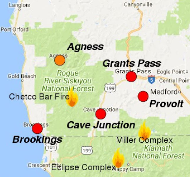


08-30-17 Miller Complex Daily Update
For a downloadable, emailable PDF of this update, click here.
Rocky Mountain Incident Management Team - Todd Pechota, Incident Commander
Information Center: (541) 899-5302
Hours of operation: 7 am – 9 pm
Email: MillerComplex2017@gmail.com
Public Meetings
Wednesday, August 30, at 6 p.m. at the Williams Elementary School (20691 Williams Hwy).
Current Situation
Today should be cooler and more humid as a marine front moves through the area; smoke may begin to clear out with its passage. As the smoke inversion lifts, fire activity may increase, but decrease again late in the afternoon with the cooler and wetter conditions brought by the marine front. Unprecedented heat, however, will follow this front. There is still potential for fire growth on all fires within the complex with continued long-term hot and dry conditions.
Evacuations
The Joe Bar area, which is in California, went under an evacuation order yesterday afternoon. This means that evacuation was necessary in order to protect the lives of area occupants and emergency personnel responding to the incident. The Abney fire slowly backed down surrounding hills near the residences; suppression crews were able to hold all firelines near this community.
The following areas are under a Level 1 (Be Ready) Evacuation Notice:
• Palmer Creek Road and Kinney Creek Road (Forest Service Road 1090)
• Both sides of Upper Applegate Road from Palmer Creek Road to the Applegate Dam Spillway (This includes Bolder City)
• Beaver Creek Road
• Carberry Creek Road from Applegate Road up to and including Steamboat Ranch
Branch I: Creedence Fire and Bigelow Fire (Grayback Fire)
Crews continued to hold suppression lines on the west side yesterday. Focus here continues on establishing and strengthening control lines by using existing roads. The fires in this Branch are approximately 7 miles south of Williams and 2 miles east of Oregon National Monument and Preserve.
Branch II: Burnt Peak Fire
Firefighters are using existing roads to halt the fire’s progression from the north and south by laying hose and digging handline. The fire continues to move down the slope towards the Applegate Road at a very slow pace. This Branch is approximately 9 miles southwest of Ruch and 3 miles north of Applegate Lake.
Branch III: Abney Fire (Abney, Seattle and Cook Fires)
Structure protection is continuing in the Joe Bar area. Some resources were shifted to this fire yesterday to establish, reinforce, and maintain control lines on the northwest side of the this fire. Firefighters are scouting and prepping additional control lines along Forest Service Road 1035 (northwest side) and along 1050 (northeast side) of the fire. Additional resources were made available from the Klamath National Forest to prep a small portion of the Klamath/Rogue River-Siskiyou National Forest boundaries (along the Pacific Crest Trail). This fire is burning in Oregon and California south of Applegate Lake. The community of Joe Bar is near the northeast perimeter of the fire.

Closures
The Rogue River-Siskiyou National Forest has closed three areas on the Siskiyou Mountains Ranger District including National Forest land between Kinney and Palmer creeks; the Grayback Mountain area; and the areas south of Applegate Lake. Local residents are allowed to access their property; please bring proof of residence. For specific descriptions and maps of the closures see https://www.fs.usda.gov/alerts/rogue-siskiyou/alerts-notices.
The Bureau of Land Management has closed the Grayback Mountain Trailhead. On the adjacent Klamath National Forest, additional closures are in place for the Eclipse Fire, including a portion of the Pacific Crest Trail. Refer to https://www.fs.usda.gov/alerts/klamath/alerts-notices.
Fire Statistics
Start Date: August 14, 2017
Cause: Lightning
Complex Sized: 12,956 acres
Complex Containment: 40%
Total Personnel: 563
Social Media Resources
Twitter: #MillerComplex

8-29-17 Miller Complex Daily Update
For a downloadable, emailable PDF of this update, click here.
Rocky Mountain Incident Management Team - Todd Pechota, Incident Commander
Information Center: (541) 899-5302
Hours of operation: 7 am – 9 pm
Email: MillerComplex2017@gmail.com
Public Meetings
Tuesday, August 29 at 6 p.m. at Applegate Fire District Headquarters (1095 Upper Applegate Road)
in the training building and Wednesday August 30 at 6 pm at the Williams Elementary School (20691 Williams Hwy).
Current Situation
The fires continue to move slowly throughout the complex, but are still actively burning. The
weather will remain hot and dry through mid-week. Due to weather conditions, there is potential for growth on all fires in the complex, particularly in the late afternoon and evening. Dense smoke is expected to persist through the area, creating poor air quality and hampering use of air resources.
Evacuations
As a precautionary measure, the Level 1 (Be Ready) Evacuation area has been expanded. The following areas are now under a Level 1 Evacuation Notice:
- Palmer Creek Road and Kinney Creek Road (Forest Service Road 1090)
- Both sides of Upper Applegate Road from Palmer Creek Road to the Applegate Dam Spillway (This includes Bolder City)
- Beaver Creek Road
- Carberry Creek Road from Applegate Road up to and including Steamboat Ranch
- Joe Bar area, which is in California, is under an evacuation warning. An evacuation warning means that residents should be prepared to evacuate.
Branch I: Creedence Fire and Bigelow Fire (Grayback Fire)
Crews successfully completed firing operations on the west side down to Little Creek. Focus remains on establishing and strengthening control lines by using existing roads. Efforts were greatly assisted by the ability to conduct air operations yesterday, which allowed crews to move critical equipment into the area. The fires in this Branch are approximately 7 miles south of Williams and 2 miles east of Oregon National Monument and Preserve.
Branch II: Burnt Peak Fire
Firefighters are using existing roads to halt the fire’s progression from the north and south by laying hose and digging handline. The fire continues to move down the slope towards the Applegate Road at a very slow pace. This Branch is approximately 9 miles southwest of Ruch and 3 miles north of Applegate Lake.
Branch III: Abney Fire (Abney, Seattle and Cook Fires)
The Abney, Seattle, and Cook fires have burned together and will be referred to as the Abney Fire. This branch exhibited moderate fire activity yesterday as firefighters continue to build and improve control lines on the north and east flanks. These fires are burning in Oregon and California south of Applegate Lake. The community of Joe Bar is ½ mile northeast of the fire.

Closures
The Rogue River-Siskiyou National Forest has closed three areas on the Siskiyou Mountains Ranger
District including National Forest land between Kinney and Palmer creeks; the Grayback Mountain area; and the areas south of Applegate Lake. Local residents are allowed to access their property; please bring proof of residence.
The Bureau of Land Management has closed the Grayback Mountain Trailhead. For specific descriptions and maps of the closures see http://bit.ly/2vx1Ahq.
Fire Statistics
Start Date: August 14, 2017
Cause: Lightning
Complex Size: 10,866 acres
Total Personnel: 550
Complex Containment: 48%
Social Media Resources
Twitter: #MillerComplex
08-29-17 Miller Complex Smoke Forecast
For a downloadable, emailable PDF of this update, click here.
Smoke
Light onshore flow has drifted smoke out of coastal areas and eastward this morning. Brookings-Harbor, Gold Beach, Agness and Cave Junction have seen a reprieve in smoke impacts where Moderate conditions exist. Inland in the Grants Pass region, heavy smoke impacts remain. Through the day, smoke will continue to drift north and east as well down into local valleys close to active fires. Agness, Brookings, Gold Beach and Cave Junction should see conditions degrade to Unhealthy this evening. Provolt and Grants Pass will remain in the Unhealthy range. Regionally, upper elevation SW winds will drift smoke from Chetco Bar and other fires again north toward Washington.


08-28-17 Miller Complex Daily Update
For a downloadable, emailable PDF of this update, click here.
Rocky Mountain Incident Management Team - Todd Pechota, Incident Commander
Information Center: 541-899-5302
Hours of operation: 7 am – 9 pm
Email: MillerComplex2017@gmail.com
Three firefighters working in the Miller Complex were injured yesterday in a vehicle accident when their engine rolled off the road near the junction of Forest Service Roads 1030 and 1035. One firefighter has serious injuries and two received minor injuries. The families of the three injured have been notified. The accident is under investigation. No additional information, including the names of the injured firefighters and the nature of their injuries, will be released at this time.
Public Meetings
Tuesday August 29 at 6 pm at Applegate Fire District #9 in the training building and Wednesday August 30 at 6 pm at the Williams Elementary School.
Current Situation
The fires continue to move slowly in most areas, but are still actively burning. The weather will continue to become hotter and drier through mid-week, which is expected to increase fire behavior. There is potential for growth on all fires in the complex, particularly in the late afternoon and evening. Smoke continues to create poor air quality and hamper use of air resources.
For a downloadable, emailable PDF of this map, click here.

Branch I: Creedence Fire and Bigelow Fire (Grayback Fire)
Crews continue to focus on establishing control lines on the west side of the fire using existing roads. The west side of the fire is holding along Little Creek. Firing operations are being conducted to keep up with the natural progression of the fire on the west side. The fires in this Branch are approximately 7 miles south of Williams and 2 miles east of Oregon National Monument and Preserve.
Branch II: Burnt Peak Fire
Firefighters are using existing roads to halt the fire’s progression from the north and south by laying hose and digging handline as needed. The fire continues to move down the slope towards the Applegate Road at a very slow pace. This Branch is approximately 9 miles southwest of Ruch and 3 miles north of Applegate Lake.
Branch III: Seattle Fire, Abney Fire and Cook Fire
Firefighters continue to build and improve control lines on the north and east flanks, while looking for opportunities to establish lines on the south and west. These fires are burning in Oregon and California south of Applegate Lake. The community of Joe Bar is ½ mile north of the fire.
Evacuations and Closures: The Rogue River-Siskiyou National Forest has closed three areas on the Siskiyou Mountains Ranger District including National Forest land between Kinney and Palmer creeks; the Grayback Mountain area; and the areas south of Applegate Lake. Local residents are allowed to access their property; please bring proof of residence. The Bureau of Land Management has closed the Grayback Mountain Trailhead.
For specific descriptions and maps of the closures see http://bit.ly/2vx1Ahq.
As a precautionary measure, Level 1 (Be Ready) Evacuation Notices were issued on 8/26/17 for: Palmer Creek Road at Upper Applegate Road to the 1090/1095 split, west of Upper Applegate Road and east of Applegate River from Palmer Creek Road to Jackson Campground (11,000 block), Bolder City at 11425 Upper Applegate Road, Carberry Creek Road at Applegate Road to Steamboat Ranch, and the Joe Bar area.
Fire Statistics
Start Date: August 14, 2017
Cause: Lightning
Complex Sized: 9,628 acres·
Total Personnel: 550 Complex
Containment: 48%
Social Media Resources
Twitter: #MillerComplex
08-28-17 Miller Complex Smoke Forecast
For a downloadable, emailable PDF of this update, click here.
Smoke
Very heavy to hazardous smoke impacts exist this morning as smoke from the Chetco Bar Fire has drained down canyon into local communities overnight. Visibility is significantly reduced on local roadways, including Highway 101. Coastal areas such as Gold Beach and Brookings-Harbor should see some reprieve in air quality this afternoon as a light sea breeze is expected to lift smoke. Agness and the Rogue River valley are expected to be Unhealthy to Very Unhealthy today. Cave Junction, Grants Pass, Ashland and surrounding communities are expected to see Unhealthy conditions through the day. In the regional scale, Southwesterly transport winds are expected to drift smoke produced from Chetco Bar and other active fires in the region again to the North toward Washington.


08-27-17 Miller Complex Daily Update
Rocky Mountain Incident Management Team - Todd Pechota, Incident Commander
Hours of operation: 7 am – 9 pm
Information Center: 541-899-5302
Email: MillerComplex2017@gmail.com
Public Meetings
Tuesday, August 29 at 6 pm at Applegate Fire District #9 (1095 Upper Applegate Rd) in the training building and Wednesday, August 30 at 6 pm at the Williams Elementary School (20691 Williams Hwy).
Current Situation
The fires continue to move slowly in most areas, but are still experiencing some active burning conditions. The weather will continue to become hotter and drier through Monday, which is expected to increase fire behavior. There is potential for growth on all fires in the complex. Smoke continues to create poor air quality and hamper use of air resources.
Branch I: Creedence Fire and Bigelow Fire (Grayback Fire)
Crews continue to focus on establishing control lines on the west side of the fire using existing roads toward Little Creek. Firing operations are being conducted as necessary to keep up with the natural progression of the fire on the west side. The fires in this Branch are approximately 7 miles south of Williams and 2 miles east of Oregon National Monument and Preserve.
Branch II: Burnt Peak Fire
Firefighters are using existing roads to box the fire’s progression from the north and south. Firing operations were conducted yesterday to slowly ease the fire to the control lines. This Branch is approximately 9 miles southwest of Ruch and 3 miles north of Applegate Lake.
Branch III: Seattle Fire, Abney Fire and Cook Fire
Firefighters continue to build and improve control lines on the north and east flanks, while looking for opportunities to establish lines on the south and west. Firing operations will continue, as needed, using indirect line north and west of Strickland Butte. These fires are burning in Oregon and California south of Applegate Lake. The community of Joe Bar is ½ mile north of the fire.
Rocky Mountain Incident Management Team - Todd Pechota, Incident Commander
Hours of operation: 7 am – 9 pm
Hours of operation: 7 am – 9 pm
Tuesday, August 29 at 6 pm at Applegate Fire District #9 (1095 Upper Applegate Rd) in the training building and Wednesday, August 30 at 6 pm at the Williams Elementary School (20691 Williams Hwy).
The fires continue to move slowly in most areas, but are still experiencing some active burning conditions. The weather will continue to become hotter and drier through Monday, which is expected to increase fire behavior. There is potential for growth on all fires in the complex. Smoke continues to create poor air quality and hamper use of air resources.
 |
| Miller Complex 8-27-17 Fire Map |
Evacuations and Closures
The Rogue River-Siskiyou National Forest has closed three areas on the Siskiyou Mountains Ranger District in support of fire suppression efforts, including National Forest land between Kinney and Palmer creeks; the Grayback Mountain area; and the areas south of Applegate Lake. Local residents will be allowed to access their property; please bring proof of residence. The Bureau of Land Management has closed the Grayback Mountain Trailhead. For specific descriptions and maps of the closures, go to: https://www.fs.usda.gov/detail/rogue-siskiyou/home/?cid=fseprd555085.
As a precautionary measure, Level 1 (Be Ready) Evacuation Notices were issued for the following areas:
- Palmer Creek Road at Upper Applegate Road to the 1090/1095 split
- West of Upper Applegate Road and east of Applegate River from Palmer Creek Road to Jackson Campground (11,000 block)
- Boulder City at 11425 Upper Applegate Road
- Carberry Creek Road at Applegate Road to Steamboat Ranch
- Joe Bar area
(For a map of these evacuations, please see the Miller Complex tab on our page)
Fire Statistics
Start Date: August 14, 2017
Start Date: August 14, 2017
Cause: Lightning
Complex Sized: 14,066 acres
Complex Sized: 14,066 acres
Total Personnel: 537
Complex Containment: 48%
Complex Containment: 48%
Twitter: #MillerComplex
08-27-17 Miller Complex Smoke Forecast
For a downloadable, emailable PDF of this update, click here.
Smoke
Very heavy smoke impacts are expected today in regional communities surrounding the Chetco Bar Fire. Coastal areas such as Gold Beach and Brookings-Harbor will see the majority of impacts along with Agness and the Rogue River Valley. In these areas expect Unhealthy and Very Unhealthy air quality conditions along with reduced visibility along Highway 101. Cave Junction, Grants Pass, Ashland and surrounding communities are also expected to see Unhealthy conditions from Chetco Bar and other fires in the region. Not only is smoke produced from the active fires draining into local valleys, smoke is also drifting into the Willamette Valley to Portland with light southwesterly winds.


08-26-17 Miller Complex Daily Update
For a downloadable, emailable PDF of this update, click here.Rocky Mountain Incident Management Team - Todd Pechota, Incident Commander
(See maps below)
Information Center: 541-899-5302
Hours of operation: 7 am – 9 pm
Email: MillerComplex2017@gmail.com
Hours of operation: 7 am – 9 pm
Email: MillerComplex2017@gmail.com
Current Situation
Favorable weather conditions kept fire activity on the Miller Complex fires minimal yesterday. Firefighters continued to prepare for an anticipated increase in fire activity in the coming days from warmer and drier weather. Crews on all three branches continue to build and prep control lines.
Favorable weather conditions kept fire activity on the Miller Complex fires minimal yesterday. Firefighters continued to prepare for an anticipated increase in fire activity in the coming days from warmer and drier weather. Crews on all three branches continue to build and prep control lines.
 |
| Applegate/Palmer Creek Road area |
 |
| Carberry Creek Road at Applegate Road to Steamboat Ranch |
Evacuations
As a precautionary measure, the Rocky Mountain Incident Management Team and local officials have issued a Level 1 (Be Ready) Evacuation Notice for the following areas:
As a precautionary measure, the Rocky Mountain Incident Management Team and local officials have issued a Level 1 (Be Ready) Evacuation Notice for the following areas:
Palmer Creek Road at Upper Applegate Road to the 1090/1095 split
West of Upper Applegate Road and east of Applegate River from Palmer Creek Road to Jackson Campground (11,000 block)
Boulder City at 11425 Upper Applegate Road
Carberry Creek Road at Applegate Road to Steamboat Ranch
Joe Bar area
 |
| Joe Bar area |
Residents of Jackson and Josephine counties in Oregon can register for emergency citizen alerts at www.rvem.org. Residents of Siskiyou County in California can register at http://www.co.siskiyou.ca.us/content/oes-codered.
Branch I: Creedence Fire and Bigelow Fire (Grayback Fire)
Crews continue to focus on establishing control lines on the west side of the fire using existing roads and building hand line.
Crews continue to focus on establishing control lines on the west side of the fire using existing roads and building hand line.
Branch II: Burnt Peak Fire
Firefighters are focusing efforts on the eastern perimeter of the Burnt Peak Fire using existing roads to box the fire’s progression from the north and south.
Firefighters are focusing efforts on the eastern perimeter of the Burnt Peak Fire using existing roads to box the fire’s progression from the north and south.
Branch III: Seattle Fire, Abney Fire and Cook Fire
Firefighters continue to build and improve control lines on the north and east flanks while looking for opportunities to establish lines on the south and west.
Firefighters continue to build and improve control lines on the north and east flanks while looking for opportunities to establish lines on the south and west.
Closures
The Rogue River-Siskiyou National Forest has closed three areas on the Siskiyou Mountains Ranger District in support of fire suppression efforts, including National Forest land between Kinney and Palmer creeks; the Grayback Mountain area; and the areas south of Applegate Lake. Local residents will be allowed to access their property; please bring proof of residence. The Bureau of Land Management has closed the Grayback Mountain Trailhead. For specific descriptions and maps of the closures, go to: https://www.fs.usda.gov/detail/rogue-siskiyou/home/?cid=fseprd555085.
The Rogue River-Siskiyou National Forest has closed three areas on the Siskiyou Mountains Ranger District in support of fire suppression efforts, including National Forest land between Kinney and Palmer creeks; the Grayback Mountain area; and the areas south of Applegate Lake. Local residents will be allowed to access their property; please bring proof of residence. The Bureau of Land Management has closed the Grayback Mountain Trailhead. For specific descriptions and maps of the closures, go to: https://www.fs.usda.gov/detail/rogue-siskiyou/home/?cid=fseprd555085.
Fire Statistics
Location: 17 miles east of Cave Junction, OR
Start Date: August 14, 2017
Cause: Lightning
Complex Sized: 14,066 acres
Total Personnel: 464 Complex
Containment: 48%
Social Media Resources
Website: https://inciweb.nwcg.gov/incident/5514/#
Facebook: https://www.facebook.com/MillerComplexFires/ or https://facebook/R6RRSNF
Twitter: #MillerComplex

No comments:
Post a Comment
Note: Only a member of this blog may post a comment.