9-29-17 High Cascades Complex West Fire Daily Update
Special Announcements: Smoke from California wildfires has drifted north into the area. Please check the Air Quality websites below for the most up to date information on smoke in your specific location.
The significant rain event previously predicted for the area on Tuesday has been downgraded to where even a wetting rain might not materialize. Forecast models are no longer showing the 1/2 to 1 inch of rain.
Fire Information Center: (541) 316-8352 Available 8:00 am to 9:00 pm.
Information Websites: Inciweb – https://inciweb.nwcg.gov/incident/5503 and Facebook https://www.facebook.com/R6RRSNF and https://facebook.com/UmpquaNationalForest/
Incident Management Team: Northwest Interagency Incident Management Team 8, Incident Commander, Tim Keith, is managing the High Cascades Complex - West Zone. The incident command post (ICP) is located at the Joseph Stewart State Park near Lost Creek Reservoir southwest of Prospect, Oregon. A spike camp is located at Milo Academy near Milo, Oregon.
Current Fire Information: Pup – 8,273 acres, 13% contained. Located northwest and southeast of Hershberger Lookout partially in the Rogue-Umpqua Divide Wilderness. Suppression repairs have been completed on the handline along the south flank. Crews are patrolling and mopping-up hot spots. The north indirect containment line along Forest Road (FR) 2840 has been cleaned up and equipment is repairing any road damage. Merchantable logs are being decked for future use. On the east indirect line along FR 6520, vegetation and slash generated from indirect fire line construction is being hauled by dump trucks to a near-by rock pit for storage and later processing or burning.
Broken Lookout – 19,142 acres, 27% contained. Located directly west of Union Creek on the southern end of the Rogue-Umpqua Divide Wilderness where it is burning on both sides of the Wilderness. On the south flank, firefighters are tightening lines to reduce acres lost and tie in the fire edge , inside of the current indirect containment lines. Firefighters are repairing secondary, unneeded dozer containment lines. Along FR 700 chipping of vegetative debris generated from indirect fire line construction continues. Mopping up is proceeding along the south flank.
Resources: Total personnel assigned to the Complex (both Zones) – 497: 1-type 1 crew, 2-type 2 IA crews, 6-type 2 crews, 6-camp crews, 9-engines, 4-masticators, 2-medium helicopters, 2- light helicopters, 1-dozer, 4-water tenders, and 91 overhead.
Air Operations: A temporary flight restriction (TFR) is in place over the fire area restricting aerial public access. Please check the NOTAMs prior to flying. The public is reminded all air operations are grounded any time a drone is sighted within the TFR, delaying fire suppression efforts. Flying within the TFR is prohibited and against the law. The helibase is located at the Prospect Airport and is closed to public use. The airport is planned to reopen on October 15th.
Air Quality: Pollutants are present at a moderate level due to smoke from fires in California drifting into southern Oregon. For the most up to date air quality reported for your area see Air Now
http://www.airnow.gov/ or the Oregon Smoke Blog http://oregonsmoke.blogspot.com
Weather: Yesterday was the last of the warmer, drier weather for at least the next week. A cold front
moved into the area bringing cooler temperatures, higher relative humidity, and potential for rain
showers. Maximum temperatures are forecasted for 64 degrees and relative humidity 40-60% percent thisafternoon. Ridgetop winds will be southwest turning to northwest and increasing 7-10 mph in the
afternoon.
Behavior: Fine dead fuels moisture continues to be low, however the vast majority of the fire fuels are starting to moiston. The greatest fire behavior potential will be on south facing slopes or under a more open canopy. Smoldering duff could kindle to a low intensity surface fire with minimal ground spread, with correct wind alignment. Creeping and smoldering may re-establish in the litter, duff and jackpots (piles) of dead and down fuels.
Closures: Multiple area, trail, and Forest road closures are limiting public access into specific areas for public safety. “Know before you go” by visiting https://inciweb.nwcg.gov/incident/5503 or your local Forest office. Know: the forecasted weather; road, trail and area closure information; and be aware of firefighters working in the vicinity of your recreational activities.


9-28-17 High Cascades Complex West Fire Daily Update
Fire Information Center: (541) 316-8352 Available 8:00 am to 9:00 pm.
Information Websites: Inciweb – https://inciweb.nwcg.gov/incident/5503 and Facebook https://www.facebook.com/R6RRSNF and https://facebook.com/UmpquaNationalForest/
Current Fire Information: The High Cascades Complex - West Zone is a compilation of fires started by lightning storms earlier this summer. The West Zone consists of the Pup and the Broken Lookout Fires. Both fires are partially burning in and outside of the Rogue-Umpqua Divide Wilderness on the Rogue River-Siskiyou and Umpqua National Forests. Firefighters are making significant progress with suppression and vegetation clean-up on all divisions. The information from a nighttime infra-red, heat detecting flight displayed fire perimeter locations therefore the acreages where slightly increased.
Pup – 8,273 acres, 13% contained. Located northwest and southeast of Hershberger Lookout partially in the Rogue-Umpqua Divide Wilderness. Suppression repairs have been completed on the handline along the south flank. Crews are patrolling and mopping-up hot spots. The north indirect containment line clean-up has been completed and equipment is repairing any road damage. Hauling of piled vegetation generated from indirect fire line constructed along forest roads is progressing along the east indirect containment lines.
Broken Lookout – 19,142 acres, 27% contained. Located directly west of Union Creek on the southern end of the Rogue-Umpqua Divide Wilderness where it is burning on both sides of the Wilderness. Firefighters are assessing repairs needed on the south, southwest, and west indirect containment lines. Firefighters are chipping vegetative debris generated from indirect fire line construction along forest roads and patrolling for hotspots. Mopping up is proceeding along the south flank.
Resources: Total personnel assigned to the Complex (both Zones) – 604: 2-type 1 crews, 2-type 2 IA crews, 8-type 2 crews, 6-camp crews, 13-engines, 4-masticators, 3-medium helicopters, 2- light helicopters, 1-dozer, 5-water tenders, and 253 overhead.
Air Operations: A temporary flight restriction (TFR) is in place over the fire area restricting aerial public access. Please check the NOTAMs prior to flying. The public is reminded all air operations are grounded any time a drone is sighted within the TFR, delaying fire suppression efforts. Flying within the TFR is prohibited and against the law. The helibase is located at the Prospect Airport and is closed to public use. The airport is planned to reopen on October 15th.
Air Quality: For the most up to date air quality reported for your area see Air Now http://www.airnow.gov/ or the Oregon Smoke Blog http://oregonsmoke.blogspot.com
Weather: Warmer and drier conditions are expected again today under sunny skies with southeast ridgetop winds in the morning. Becoming terrain driven in the afternoon. Temperatures, 79 to 84 degrees and relative humidity, 20 – 35% percent this afternoon. Ridgetop winds will be southeast 6 – 9 mph. Friday through Monday a cold front is expected to pass with wetting rain possible Friday and significant rainfall by Tuesday.
Behavior: Fine dead fuels moistures will be low today, however the vast majority of the fires are still moist to wet. The greatest fire behavior potential will be on south facing slopes or under a more open canopy. Smoldering duff may kindle to a low intensity surface fire with minimal ground spread. Creeping and smoldering may re-establish in the litter, duff and jackpots (piles) of dead and down fuels.
Closures: Multiple area, trail, and Forest road closures are limiting public access into specific areas for public safety. “Know before you go” by visiting https://inciweb.nwcg.gov/incident/5503 or your local Forest office. Know: the forecasted weather; road, trail and area closure information; and be aware of firefighters working in the vicinity of your recreational activities.

High Cascades Complex East Fire Daily Update
Will be posted every other day

9-27-17 High Cascades Complex West Fire Daily Update
Northwest Interagency Incident Management Team 8, Incident Commander: Tim Keith
Special Announcements: General Westside Deer hunting season opens this week-end. The Rogue River-Siskiyou and the Umpqua National Forests encourage Forest visitors to “Know before you go”! Know: the forecasted weather; road, trail and area closure information; and be aware of firefighters working in the vicinity of your hunting activities.
Fire Information Center: (541) 316-8352 Available 8:00 am to 9:00 pm.
Information Websites: Inciweb – https://inciweb.nwcg.gov/incident/5503 and Facebook https://www.facebook.com/R6RRSNF and https://facebook.com/UmpquaNationalForest/
Incident Management Team: Northwest Interagency Incident Management Team 8, Incident Commander, Tim Keith, is managing the High Cascades Complex - West Zone. The incident command post (ICP) is located at the Joseph Stewart State Park near Lost Creek Reservoir southwest of Prospect, Oregon. A spike camp is located at Milo Academy in Milo, OR.
Current Fire Information: The High Cascades Complex - West Zone is a compilation of fires started by lightning storms earlier this summer. The West Zone consists of the Pup and the Broken Lookout Fires. Both fires are partially burning in and outside of the Rogue-Umpqua Divide Wilderness on the Rogue River-Siskiyou and Umpqua National Forests. Firefighters are making significant progress with suppression and vegetation clean-up. Structures are being unwrapped from protective coverings. Cleanup including pulling flagging, removing signs, and garbage cleanup is occurring across all divisions.
Pup – 8,222 acres, 13% contained. Located northwest and southeast of Hershberger Lookout partially in the Rogue-Umpqua Divide Wilderness. Indirect containment line on the north has been completed. Hauling of piled vegetation generated from indirect fire line constructed along forest roads is progressing. Snag removal along these roads for safe travel has been completed. Other firefighters are mopping up hotspots.
Broken Lookout – 19,114 acres, 27% contained. Located directly west of Union Creek on the southern end of the Rogue-Umpqua Divide Wilderness where it is burning on both sides of the Wilderness. Firefighters are chipping vegetative debris generated from indirect fire line construction along forest roads and patrolling for hotspots.
Resources: Total personnel assigned to the Complex (both Zones) – 648: 1-type 1 crew, 2-type 2 IA crews, 10-type 2 crews, 6-camp crews, 13-engines, 5-masticators, 3-medium helicopters, 2- light helicopters, 1-dozers, 5-water tenders, and 215 overhead.
Air Operations: A temporary flight restriction (TFR) is in place over the fire area restricting aerial public access. Please check the NOTAMs prior to flying. The public is reminded all air operations are grounded any time a drone is sighted within the TFR, delaying fire suppression efforts. Flying within the TFR is prohibited and against the law. The helibase is located at the Prospect Airport and is closed to public use. The airport is planned to reopen on October 15th.
Air Quality: For the most, up to date air quality reported for your area see Air Now http://www.airnow.gov/ or the Oregon Smoke Blog http://oregonsmoke.blogspot.com
Weather: Warmer and drier conditions are expected again today under sunny skies with light east/southeast ridgetop winds. The winds will bring higher temperatures, 77 to 82 degrees and decreasing relative humidity, 20 – 50% percent this afternoon. Ridgetop winds will be northeast 6 – 9 mph. Friday through Monday a cold front is expected to pass with wetting rain possible Friday and significant rainfall by Tuesday.
Behavior: Expected fire behavior is very low intensity surface fire in sheltered fuels under dense canopy with minimal ground spread with no perimeter growth. Creeping and smoldering may re-establish in the litter, duff and jackpots (piles) of dead and down fuels. Active fire was observed yesterday in several snags and piles of fuel. All were well interior of the containment lines.
Closures: Multiple area, trail, and Forest road closures are limiting public access into specific areas for public safety. “Know before you go” by visiting https://inciweb.nwcg.gov/incident/5503 or your local Forest office.


9-27-17 High Cascades Complex East Fire Daily Update
Special Announcements: Limited phone calls and
lack of fire activity eliminated the need for an additional fire information
line at Crater Lake National Park. As of 0600 today, CLNP fire information can
be obtained by calling the main line at 541.238.7164. Fire information boards
will be updated every few days as needed. The incident meteorologist expects
weather to reach the high 70’s on Thursday, but temperatures will decrease
dramatically as a wet cold front moves in this weekend. There is some potential
for aggressive creeping on Thursday, but that will be put to rest as cooler
temperatures impede the fire’s ability to grow.
Current Fire Information: Despite the rigors of the
job, crews remained committed to the operational task at hand, completing 63%
of the total repairs identified on the fires. Emphasis again was on chipping,
grading and hand and dozer repair. Milestones reached today included the
successful repair of the trailhead on North Pelican, the unwrapping of the
Honeymoon Cabin on the Blanket Creek Fire and the near 100% completion of
suppression repair on the Spruce Lake Fire. As road crews finish work on North
Pelican they will move north to assist crews on the Blanket Creek Fire and
begin grading FS Rd. 3228
Air Operations: Air operations had one of their
busiest days yesterday logging a total of 6 flight hours and hauling 3200
pounds of cargo and 16 passengers to various drop points on the fires.
Closures: Fire closures remain on public lands
within some hunting units. The Pacific Crest Trail (PCT) is closed at several
points on the Fremont-Winema National Forest, Sky Lakes Wilderness and Crater
Lake National Park due to safety concerns. Check trail, road, and area closures
on InciWeb, park and forest websites. West Rim Drive in Crater Lake National
Park remains closed for scheduled maintenance and repaving through Friday at 4
p.m.
Weather: Friday afternoon a cold front will move
through the fire and result in much cooler temperatures, high relative humidity
and gusty west winds on the ridge tops. The cooler unsettled weather will last
well into next week and will result in widespread wetting rain.
Traffic: Expect possible delays on Highway 230 between Union Creek and the junction with Highway 138 due to road construction. In Crater Lake National Park, heavy construction traffic may bring delays near North Junction.
Quick Facts of the Incident Summary
Fire Locations: Rogue
River-Siskiyou NF-High Cascades Ranger District, Fremont-Winema
NF-Klamath Ranger District, Crater Lake National Park
Approximate Acreage: 52,737 acres (East Zone only)
Containment: 40% (East Zone only)
Suppression Repair: 63% (East Zone
only)
Start Dates: North Pelican –
08.10.2017, Spruce Lake – 07.29.2017, Blanket
Creek – 07.26.2017
Cause: Lightning
Incident Commander: Tim Roide, Great
Basin Type 2 Incident Management Team #4
Resources on the Fires: 4 handcrews, 4
engines, 2 helicopters
Total Personnel: 223
Online
Links
Twitter:
@SCOFMPFIREINFO
@SCOFMPFIREINFO
Fire
Closures: https://inciweb.nwcg.gov/incident/5503
Smoke
Information: http://oregonsmoke.blogspot.com/


9-26-17 High Cascades Complex East Fire Daily Update
Summary: Crews continued chipping away on repair efforts; increasing repair completion to 43 percent. Aerial operations assisted firefighters by shuttling crews and supplies into difficult to reach areas. While a warm and dry weather trend continued, high clouds prevented major temperature increases. Lingering snow remained a hurdle to repair operations but continued to slow remaining fire activity. Fire perimeters have little potential for movement. Grading operations are progressing smoothly as heavy equipment operator continue to overhaul roads impacted by operations.
North Pelican (27% repair complete): Crews cleaned the trailhead at the end of Cold Springs Road leading into the wilderness. Chipping is expected to continue on the North Pelican for the next several days to remove excess slash along the roads. In addition to hand work, three excavators will repair access roads surrounding the fire.
Blanket Creek Fire (45% repair complete): Firefighters finished much of the rehab work on the southeastern edge of the fire perimeter. Heavy equipment operators will continue scouting the dozer lines closer to Mazama Village to develop a timeline for repairs. The protective material surrounding the Honeymoon Cabin is expected to be removed today.
Spruce Lake Fire (62% repair complete): Air operations provided major assistance to crews on the Spruce Lake Fire by transporting 4,350 pounds of cargo to the Hotshot Crew repairing handline. A crew working in the backcountry is expected to reach the West Rim Road tomorrow.
Closures: Fire closures remain on public lands within some hunting units. Check trail, road, and area closures on InciWeb, park and forest websites. West Rim Drive in Crater Lake National Park remains closed for scheduled maintenance and repaving through Friday at 4 p.m.
Weather: The warming and drying trend should continue through Thursday when highs will reach the mid-70s and daytime relative humidity will drop to 30% or less. Long-range forecasts suggest a renewed wetter pattern by early next week.
Traffic: Expect possible delays on Highway 230 between Union Creek and the junction with Highway 138 due to road construction. In Crater Lake National Park, heavy construction traffic may bring delays near North Junction.


9-26-17 High Cascades Complex West Fire Daily Update

Fire
Information Center: (541) 316-8352 Available 8:00 am to 9:00
pm.
The
incident command post (ICP) is located at the Joseph Stewart State Park near
Lost Creek Reservoir southwest of Prospect, Oregon.
Information
Websites: Inciweb – https://inciweb.nwcg.gov/incident/5503 and
Facebook https://www.facebook.com/R6RRSNF
and https://facebook.com/UmpquaNationalForest/
Current
Fire Information: The High Cascades Complex - West Zone is a compilation of fires
started by lightning storms earlier this summer. The West Zone consists of the Pup and the
Broken Lookout Fires. Both fires are
partially burning within and outside of the Rogue-Umpqua Divide Wilderness on
the Rogue River-Siskiyou and Umpqua National Forests. Suppression and repair work
is underway in most divisions.
Pup – 8,222 acres, 12%
contained. Located partially in the
Rogue-Umpqua Divide Wilderness, northwest and southeast of Hershberger Lookout. Several areas of heat were located along the
north and south flanks yesterday. Crews are mopping up these hotspots along the
fire’s edge. All heat was well within
the established containment lines. Other
firefighters are chipping debris generated by prepping forest roads for use as
containment line.
Broken Lookout
– 18,911 acres, 24% contained. Located directly west
of Union Creek on the southern end of the Rogue-Umpqua Divide Wilderness where
it is burning on both sides of the Wilderness. Multiple smokes became visible
yesterday as the temperatures increased and several areas
of heat were located along the south flank of the fire. Crews are extinguishing
these areas directly along the fire’s edge.
Firefighters are chipping the debris generated from
indirect fire line construction along forest roads used as containment lines.
Resources: Total personnel assigned
to the Complex (both Zones) – 726: 2-type 1 crews, 2-type 2 IA crews, 13-type 2 crews, 7-camp
crew, 16-engines, 5-masticators, 3-medium helicopters, 2- light helicopters,
2-dozers, 5-water tenders, and 217 overhead.
Air
Operations: A
temporary flight restriction (TFR) is in place over the fire area restricting
aerial public access. Please check the
NOTAMs prior to flying. The public is reminded all air operations are grounded
any time a drone is sighted within the TFR, delaying fire suppression efforts. Flying
within the TFR is prohibited and against the law. The helibase is located at
the Prospect Airport and is closed to public use. The airport is planned to
reopen on October 15th.
Air
Quality: For the most, up to date air quality reported for
your area see Air Now http://www.airnow.gov/
or the Oregon Smoke Blog http://oregonsmoke.blogspot.com
Weather: Warmer and drier conditions are expected
today under sunny skies with light northeast ridgetop winds. The winds will
bring higher temperatures and decreasing relative humidity this afternoon.
Temperatures are forecasted for 73- 77 degrees with relative humidity 35 – 50%
percent range. Ridgetop winds will be
northeast 6 – 9 mph.
Behavior: Expected fire behavior is for very low intensity
surface fire in sheltered fuels under dense canopy with minimal ground spread.
No perimeter growth with these conditions. Creeping and smoldering may
re-establish in the litter, duff and jackpots of dead and down fuels.
Closures: Multiple area, trail, and
Forest road closures are limiting public access into specific areas for public
safety. “Know before you go” by visiting
https://inciweb.nwcg.gov/incident/5503
or your local Forest office.


9-25-17 High Cascades Complex West Fire Daily Update
Current Fire Information: The High Cascades Complex - West Zone is a compilation of fires started by lightning storms earlier this summer. The West Zone consists of the Pup and the Broken Lookout Fires. Both fires are partially burning in and outside of the Rogue-Umpqua Divide Wilderness on the Rogue River-Siskiyou (RRSNF) and Umpqua National Forests (UPNF).
Pup – 8,222 acres, 12% contained. Located northwest and southeast of Hershberger Lookout partially in the Rogue-Umpqua Divide Wilderness. Firefighters are chipping debris generated by prepping forest roads for use as containment line and mopping up any hotspots.
Broken Lookout – 18,911 acres, 24% contained. Located directly west of Union Creek on the southern end of the Rogue-Umpqua Divide Wilderness where it is burning on both sides of the Wilderness. Firefighters continue prepping forest roads for use as containment lines, chipping the debris generated and mopping up hotspots to secure containment lines.
Resources: Total personnel assigned to the Complex (both west and east) – 853: 2-type 1 crews, 2-type 2 IA crews, 17-type 2 crews, 6-camp crew, 21-engines, 5-masticators, 3-medium helicopters, 2- light helicopters, 2-dozers, 8-water tenders, and 192 overhead.
Air Operations: A temporary flight restriction (TFR) is in place over the fire area restricting aerial public access. Please check the NOTAMs prior to flying. The public is reminded all air operations are grounded any time a drone is sighted within the TFR, delaying fire suppression efforts. Flying within the TFR is prohibited and against the law.
Weather: A weak disturbance will move through the region today. This will increase the mid to upper level cloud cover, possibly lowering temperatures over the fire areas. Tomorrow a warming and drying trend is expected throughout the week. Temperatures will increase to 70-80 degrees with relative humidity dropping to the 25-35 percent range.
Behavior: Minimal ground spread of fire is expected today with no perimeter growth. Creeping and smoldering may re-establish in the litter, duff and jackpots of dead and down fuels.
Closures: Multiple area, trail, and Forest road closures are limiting public access into specific areas for public safety on the RRSNF and UPNF. “Know before you go” by visiting https://inciweb.nwcg.gov/incident/5503 or your local Forest office.

9-25-17 High Cascades Complex East Fire Daily Update
Summary: Fire officials report the High Cascades Complex East Zone at 40% contained. Improving weather conditions and lack of fire growth is allowing firefighters to focus their efforts on suppression repair. Excavators and other heavy equipment will be shifted between fires to reflect operational needs over the next several days. Please be cognizant of heavy equipment traveling the roads in fire areas. As of Monday morning, approximately 32% of the total suppression repair work is complete.
Excavators assisted crews on the North Pelican Fire (repair work 17% complete) repair bulldozer line. Handcrews completed culvert repairs on NF Road 350 and grading occurred on NF Road 3519.
On the Blanket Creek Fire (repair work is 21% complete), chipping continued on the east flank of the burned area. Crews scouted and began repairing handline in backcountry areas of Crater Lake National Park. Crews on the Spruce Lake Fire (repair work is 52% complete) completed rehab from the forest-park boundary to the Pacific Crest Trail. Crews are making good progress at Spruce Lake, but are encountering snow as they move into higher elevations in the wilderness and national park.
Closures: Weather conditions and anticipated fire behavior allowed the Fremont-Winema National Forest to modify its fire closure areas on both the Blanket Creek and North Pelican Fires. These alterations may impact backcountry recreationalists, hunters, and OHV users. Know before you go! Check trail, road, and area closures and conditions on InciWeb, park and forest websites. West Rim Drive in Crater Lake National Park remains closed for scheduled maintenance and repaving through Friday afternoon at 4 pm.
Hunting: The Oregon Department of Fish and Wildlife does not close hunting seasons due to fire danger. However, fire closures still remain on public lands within some hunting units. Hunters are urged to check closures before heading out.
Weather: A weak disturbance is expected to move through the region on Monday. High level clouds may reduce temperatures a few degrees, but a warming and drying trend is expected through Thursday.
The Rim Visitor Center, Annie Creek Restaurant and Gift Shop, and the Mazama Campground cabins are closed for the season. Expect possible delays on Highway 230 between Union Creek and the junction with Highway 138 due to road construction.
9-24-17 High Cascades Complex West Fire Daily Update
Today is a day of transition. Northwest Team 6, which moved
into the camp at Stewart State Park two weeks ago, will be working with
incoming Northwest Team 8 throughout the day to familiarize them with the local
terrain and fire conditions and to introduce them to the tasks that have been
accomplished and those remaining to be completed.
On the east side of the Pup Fire, engine crews are
extinguishing any remnant heat from the most recent burnout operation along the
road which serves as the fire break. Despite drier conditions, there has been
no noticeable increase in fire activity on any part of the Pup or Broken
Lookout Fires.
Heavy equipment continues to clear the road approaching the
Rocky Ridge Shelter at the north end of the Pup Fire. The shelter remains
wrapped and well protected as the road work creates a greater barrier to fire
expansion. Further down the road, crews are working to cut and chip vegetation
that has encroached on the roadway.
Chipping and “storage” of woody debris until arrival of a
more efficient chipper – a “tub grinder” – are underway along the eastern edge
of the Broken Lookout Fire.
In the Huckleberry Gap area, along the 700 and 800 roads,
hand crews continue to prune away ladder fuels and remove brush and snags in
order to establish a future anchor point for burning out or holding against
oncoming flames.
As NW Incident Management Team #6 transitions to NW Team #8,
it’s interesting to consider the important people and entities that make the
fire effort possible. During the last two weeks, Four Stars Catering from Santa
Fe Springs, CA has fed approximately 700 firefighters every day with a catering
staff of 23 persons, mostly from southern California. Some of the staff get up
as early as 2 AM to start making breakfast before crews head out to the line.
The catering company also supports the film industry, and has worked on the
film sets of Grease, the Mission Impossible movies, and many others.
As the drying and warming trend continues, temperatures
today are expected to reach the low 70s, and winds will be light from the
north-northeast. Relative humidity will drop slightly to the low 40s.
Closures: Many road, trail, and area closures
are in place for the Rogue Umpqua Divide Wilderness and surrounding lands on
both the Umpqua and Rogue River-Siskiyou National Forests. Also,
with changing weather, various restrictions have been removed or relaxed.
Forest visitors should familiarize themselves with these changes before
venturing into the area. For information about closures and restrictions
visithttps://inciweb.nwcg.gov/incident/closures/5503/ or your
local Forest office.

9-24-17 High Cascades Complex East Fire Daily Update
Summary: Suppression repair for the High Cascades Complex East Zone picked up substantially with the warmer and drier weather. Firefighters removed over 20,000 feet of hose within the Blanket Creek and North Pelican Fires. Removal of additional water pumps and hoses will continue over the next few days.
On September 22, the East Zone flew an infrared mapping of the complex, which showed very few pockets of heat. The majority of heat signatures were scattered well within the interior of the three fires. Current weather forecast and an analysis completed by the incident’s fire behavior analyst does not suggest any significant fire spread in the East Zone in the coming week.
The management team continues to assess the situation and employ the right tools to complete needed suppression repair work. Equipment and crews best suited for the job will continue to work on repair. Handcrews will be used to repair handline and clean blocked culverts impacted by the fires, mitigating future erosion and water issues.
Improved weather conditions allowed for increased air operations. Helicopters logged a combined 5.4 hours of flight time and ferried 58 passengers and 4,200 pounds of cargo, largely to the Spruce Lake Fire.
A community briefing in Rocky Point was attended by 20 people and focused largely on area closures and firewood availability as a result of the suppression operation.
Similar repair work reported yesterday will continue on the North Pelican, Blanket Creek and Spruce Lake Fires. Acreage and containment remains unchanged. North Pelican (3,589 acres, 73% contained), Blanket Creek (33,322 acres, 23% contained) and Spruce Lake (15,826 acres and 22% contained).
Closures: Although modified, some area and road closures remain in place. South of the Middle Fork of the Rogue River and the South Fork 3703 trail closures have been lifted. Current closure information is available online at: https://inciweb.nwcg.gov/incident/5503. West Rim Drive in Crater Lake National Park remained closed for plowing and inspection after last week’s snowy weather.
The Rim Visitor Center will close for the season today. The Mazama Cabins, Campground and Annie Creek Restaurant and Gift Shop will close at noon on Monday Sept. 25. Motorists and visitors to the area need to be aware of delays on Highway 230 between Union Creek and the junction with Highway 138 due to road construction.

9-23-17 High Cascades Complex West Fire Daily Update
Firefighters continue to make progress securing the edges of
the Broken Lookout and Pup Fires today. Chippers are being utilized to remove
slash on many of the major road systems along the fire perimeter including the
700, 800 and 2925 roads. Work also includes masticating with large machinery
and pruning trees by hand to reduce ladder fuels. Additionally, firefighters
are knocking out lingering hot spots on the Pup Fire; there is still remnant
heat from burn-out operations pushing directly against the fire line on the
east side.
This morning, fire managers thanked firefighters for their
efforts. “The firefighters have done a great job with suppression working in
tough conditions, “said Deputy Incident Commander Ken Paul. “I toured the fire
area yesterday and I am really proud of the hard work.” In addition to wrapping up suppression tasks and chipping,
firefighters have started rehabilitation work along some roads and fire lines.
This involves cleaning out ditches and reinforcing hand line and dozer line with
erosion control measures. It is important work to accomplish before wet winter
weather arrives.
Weather: A warming and drying trend begins today that could
continue for the next week. Temperatures will rebound into the 70s and 80s by
next Wednesday. Light winds from the North-Northeast will gradually bring the
relative humidity down to 35-40% in the fire area.
Closures: New closure orders were issued on Friday by both
the Umpqua and the Rogue River-Siskiyou National Forests. The closure order
that had closed the entirety of the RRSNF administered portion of the Sky Lakes
Wilderness has been rescinded, and the closure area has been greatly reduced to
allow for access into the southern portion of the wilderness. The northern
portion of the RRSNF-administered side of the Sky Lakes Wilderness, closest to
the boundary with Crater Lake National Park, remains closed, as does the
entirety of the Prospect OHV Trail System.
The area closure on the Tiller RD will remain the same with
an additional closure of Forest Road 2823 (Castle Rock Road) due to active fire
suppression efforts in the northern portion of the Rogue Umpqua Divide
Wilderness. All Forest Service closures are still in effect until further
notice. Many other road, trail, and area closures remain in place for the Rogue
Umpqua Divide Wilderness and surrounding lands on both the Umpqua and Rogue
River-Siskiyou National Forests. Also, with changing weather, various
restrictions have been removed or relaxed. Forest visitors should familiarize
themselves with these changes before venturing into the area. For information
about closures and restrictions visit
https://inciweb.nwcg.gov/incident/closures/5503/ or your local Forest office.

9-23-17 High Cascades Complex East Fire Daily Update
Summary: Suppression repair activity increased yesterday as crews accessed more portions of the fire area. Firefighters are reporting ample amounts of snow at higher elevations. Repair work continues to focus on chipping, felling dangerous trees and fixing hand and dozer lines created in fire suppression activities. The Incident Command team is working closely with Forest Service and National Park staff to identify high priorities areas to concentrate repair efforts. A community briefing will be held today at 10:00 a.m. at the Rocky Point Fire Hall.
Closures: Weather conditions and limited fire behavior has allowed the Rogue River-Siskiyou National Forest’s High Cascades Ranger District to modify its fire closure areas. The new closure information is available online at: https://inciweb.nwcg.gov/incident/5503. The National Park Service has also lifted the level 1 evacuation notice for Mazama Village.
Firewood: Beginning today, the public will be able to cut firewood from the log pile located at the Junction of Cold Springs Rd. and Hwy 140. The Klamath Ranger District wants to remind the public to be careful in the area as fire repair operations still continue and heavy equipment will be using the road. A firewood permit is required.
North Pelican (3,589 acres, 73% contained) Crews finished grading Cold Springs Road and started chipping efforts along NF Road 350. Excavators began working on Rock Creek Lookout Road today and will continue to repair areas damaged in firefighting operations.
Blanket Creek (33,322 acres, 23% contained) Crews removed the protective covering surrounding Bessie’s Cabin and repaired handline around the structure. Chipping occurred on NF Road 547. Crews will continue chipping and pulling hose for the next few days along the northwest perimeter of the fire.
Spruce Lake (15,826 acres and 22% contained) Two hand crews continued to remove snags and other vegetation from the Pacific Crest Trail (PCT) to access and rehab the southern handline from the Forest Service boundary to Copeland Creek.
All concession facilities and services remain open for visitors to the Park. Motorists and visitors to the area also need to be aware of delays on Highway 230 between Union Creek and the junction with Highway 138 due to road construction.

9-22-17 High Cascades Complex East Fire Daily Update
Summary: Crews were back on the line Thursday, Sept. 21, evaluating and implementing rehab plans for the Spruce Lake, Blanket Creek and North Pelican Fires. Several excavators arrived at the Incident Command Post on Thursday and will begin work today repairing dozer lines as soil conditions allow. Operational repair pace will continue to increase as weather improves. No fire spread is expected for the next several days but some creeping and smoldering in the sheltered forest stands may occur at lower elevations where heat remained during the storm cycle.
Community Briefing: A community briefing to discuss current fire operations and rehab plans will be held Saturday, Sept. 23, 2017, at 10:00 a.m. at the Rocky Point Fire Hall (25600 Rocky Point Road, Klamath Falls, Oregon).
North Pelican (3,589 acres, 73% contained) Crews bladed (smoothed) portions of Cold Springs Road and evaluated repair plans for the southwest edge near the wilderness boundary. They will continue cleaning hand and dozer lines for today’s operations. A deck of logs slid off a logging truck at the Junction of Cold Springs Rd and Hwy 140. The firewood is available for the public beginning Saturday with a permit obtained from the Ranger District. Blanket Creek (33,322 acres, 23% contained).
Crews started to pull hose on the western perimeter of Blanket Creek and assess hand and dozer lines to determine what type of equipment is required to complete repair work. Crews working the eastern perimeter chipped approximately 2.5 miles of NF road 3282, while crews on the southeast perimeter pulled 3.8 miles of hose. Spruce Lake (15,826 acres and 22% contained) Two hand crews spent the day removing snags and other vegetation from the Pacific Crest Trail (PCT) to access and rehab the southern handline from the Forest Service boundary to Copeland Creek.
Based on current weather and fire behavior, the National Park Service and High Cascades Complex (East) Fire Incident Management team determined the fire no longer poses a threat to Mazama Village. The Level 1 Evacuation Notification for Mazama Village is lifted.
Closures: Forest Managers are reevaluating area closures. For more information visit https://inciweb.nwcg.gov/incident/5503. The West Rim Drive is closed until Friday at 4:00 p.m. due to construction. All concession facilities and services remain open for visitors to the Park. Motorists and visitors to the area also need to be aware of delays on Highway 230 between Union Creek and the junction with Highway 138 due to road construction.

9-22-17 High Cascades Complex West Fire Daily Update
Size: Broken Lookout 18,781 acres; Pup 7,524 acres; Total High Cascades: 79,042 ac
Fire Containment: Broken Lookout 24%; Pup 12%; Total High Cascade Complex 32%
Incident Commander: Shawn Sheldon
West Zone Resources: Line Crews: 18; Helicopters: 3; Engines: 12; Water Tenders: 10;
Heavy Equip: 17
Total Personnel: W. Zone: 711
Jurisdiction: Rogue River-Siskiyou NF, Umpqua NF
The Jackson County Sheriff has announced the removal of all
evacuation levels for the residents of the Union Creek area effective 9/20/17
at 6:00 p.m. Forest Service closures are still in effect until further notice.
On the Pup Fire, there is still remnant heat from the fire
pushing directly against the fire line on the east side. The line consists of a
road that has been prepared by brushing and chipping. Also, the fuels near the
road have been burned out to provide an effective fuel break.
A small rock slide closed a road to the north side of the
Pup Fire for a few hours on Thursday, but was removed by the end of the day. Heavy
equipment was then able to move to the end of the road providing access to the
Rocky Ridge shelter area and begin removing the “doghair” conifer and hardwoods
from the roadside as work continues to surround the fire as much as possible
with fuel breaks.
Rehabilitation work along the 6510 road, which serves as a
contingency line between the Broken Lookout Fire and the Highway 62/230
corridor, will include the grinding of prominent stumps which remain after the
felling of danger trees along the roadside. Chipping and hauling of woody
debris continues, particularly along the 700 road system immediately east of
the Broken Lookout Fire.
In the Huckleberry gap area slash is being pulled down the
the hill from the 700-800 road that follows the divide between the Rogue and
Umpqua drainages. Pruning will also be employed to reduce ladder fuels and to
further prepare this road as a future anchor point for burning out or holding
against oncoming flames.
The Remote Access Weather Station (RAWS) located just
southwest of the Broken Lookout Fire recorded a total of 2.76 inches of rain
and melted snow as of 6 pm Thursday. The RAWS near the Pup Fire showed 2.25
inches. A drying and warming trend begins today with temperatures rising into
the sixties and seventies by early next week. Light winds from the
north-northeast will gradually bring the relative humidity down to 35-40% in
the fire area.
Closures: Many road, trail, and area closures
are in place for the Rogue Umpqua Divide Wilderness and surrounding lands on
both the Umpqua and Rogue River-Siskiyou National Forests. Also,
with changing weather, various restrictions have been removed or relaxed.
Forest visitors should familiarize themselves with these changes before
venturing into the area. For information about closures and
restrictions visithttps://inciweb.nwcg.gov/incident/closures/5503/ or your
local Forest office.
Facebook: https://www.facebook.com/R6RRSNF/
Twitter: https://twitter.com/RRSNF
Oregon Smoke Blog http://oregonsmoke.blogspot.com/
Southwest Oregon Joint Information Center: http://swojic.blogspot.com/
High Cascades Complex West Zone
Fire Information: (541) 316-8352
@R6RRSNF and @SCOFMPFireInfo R6RRSNF and SCOFMPFIREINFO
High Cascade Complex East and West Map

9-21-17 High Cascades Complex West Fire Daily Update

The rain continued to fall on the Broken Lookout and Pup Fires yesterday. Overall, the Broken Lookout Fire received about 1.8 inches of rain and the Pup Fire, which is slightly higher in elevation, received approximately 2.25 inches. Even though snow levels dropped to as low as 5,300 feet, no snow fell on the fire area. More rain showers are expected today, but rainfall amounts will most likely be less than 1/10th inch. A warming trend is predicted to begin Friday which could bring dry weather for up to ten days.
While the change in weather has reduced fire activity in
exposed fuels, heat that lies beneath the ground may still hold potential for
increased fire activity. With the recent low temperatures and high
precipitation amounts, it is possible that fire behavior will remain muted in
spite of the drying trend. To remain on the safe side, however, firefighters
are proceeding with their work, preparing roads as fire breaks if needed.
Despite diminished fire activity and the current wet conditions, there is still
a lot of work to do in the field and fire traffic will remain in the area.
Helicopters will continue to support ground suppression
forces to monitor any possible fire spread as conditions dry out into the
weekend. Crews will continue prepping roads with mastication and chipping, as
well as mopping up completed burn out operations and falling hazardous snags
that pose threats to the safety of firefighters. Forest engineers have
evaluated road conditions on the Northwest side of the Pup fire and will now
allow heavy equipment to work along the 2840 and 400 roads north of Fish Lake,
starting at Rocky Ridge shelter, to clear the roads to serve as an effective
fire break. The shelter has been wrapped with heat-reflecting material to
safeguard it from fire activity.
Northwest Interagency Incident Management Team 8 has been
ordered to replace Team 6, which times out on Sunday. It is important to
complete the miles of road preparation work that has been initiated in order
for fire breaks to be in place in case fire behavior intensifies as drying
takes place.
Closures: Many
road, trail, and area closures are in place for the Rogue Umpqua Divide
Wilderness and surrounding lands on both the Umpqua and Rogue River-Siskiyou
National Forests. Also, with
changing weather, various restrictions have been removed or relaxed. Forest
visitors should familiarize themselves with these changes before venturing into
the area. For information about
closures and restrictions visit https://inciweb.nwcg.gov/incident/closures/5503/ or
your local Forest office.


9-21-17 High Cascades Complex East Fire Daily Update
Summary: Keeping crews dry in light of weather conditions was the priority for the High Cascades Complex East Zone yesterday. Rain is expected to decrease dramatically over the next few days, allowing operations to re-engage the fire. Despite the weather, crews were able to complete one mile of road blading on the North Pelican Fire and remove 5,000 feet of hose and water pumps on the Blanket Fire. With the amount of rain and snow on the landscape, operational tactics will begin to focus on suppression rehabilitation efforts. Suppression rehab involves repairing constructed fire line, areas cleared of vegetation to control the fire, to minimize erosion and return the landscape to a more natural looking condition. Often, as with this fire, suppression repair work is done by firefighters even before the fire is contained. Rehab work also includes fixing fences, roads and drainage structures damaged during fire operations.
Fire crews work closely with resource advisers from the forest and park service to protect cultural resources, threatened, endangered and sensitive species habitat, high resource areas, campgrounds and infrastructure during this process. Methods for rehab work ranges from scattering excess brush and vegetation along the dirt lines to removing soil berms created during dozer operations. The ultimate goal is to mitigate impacts caused during fire operations.
Fire acreage remains steady:
North Pelican: 3,589 acres, 73% contained
Blanket Creek: 33,322 acres, 23% contained
Spruce Lake: 15,826 acres and 22% contained
Weather: Showers will diminish through Thursday with a drying and warming trend beginning Friday.
Closures: Forest Managers are reevaluating area closures, but until that decision is made, a number of area road and trail closures are in place. For specific closure information, visit https://inciweb.nwcg.gov/incident/5503. Roads in the National Park may be closed due to weather, visitors are urged to check conditions before heading out. The West Rim Drive is closed until Friday at 4:00 p.m. due to construction. All concession facilities and services remain open for visitors to the Park. Motorists and visitors to the area also need to be aware of delays on Highway 230 between Union Creek and the junction with Highway 138 due to road construction.


9-20-17 High Cascades Complex West Fire Daily Update
Weather continues to be front and
center in the planning process for firefighters on the Broken Lookout and Pup
Fires. With winds gusting from the west-northwest from 39 to 50 mph early this
morning, crews were prepared to cut wind-thrown trees out of the roadways if
necessary to get to their assigned locations this morning. Rainfall in the fire
area ranged from .39 inches to 1.56 inches. Snow levels are expected to drop to
5500 feet today, with an accumulation of 3 inches on portions of the fire area.
Crater Lake has accumulated eight inches of snow as of this morning, and may
collect up to 18 inches before this series of storms has passed.
A warming and drying trend is
forecast for Friday through next week, and the fires may again exhibit active
fire behavior, so preparation of containment lines continues. Incident
Commander Shawn Sheldon said today, “I worked at Tiller for seven years, and
locals know that rain in mid-September does not necessarily mean that fire
season is over. We are being diligent to prepare containment lines to hold the
fire if it becomes active again.”
If bridge load limits can be
mitigated, heavy equipment will move into the northern portion of the Pup Fire
in order to clear the 2840 road for use as a fire break in the event the fire
moves to the northwest. Road preparation for use as containment line on the
southeastern portion of Broken Lookout Fire will continue. Hand-lines are being
constructed where needed, snags are being dropped for safety, and slash along
the roads is being chipped or moved. Mop-up is underway in the southwestern
part of Broken Lookout Fire in order to strengthen containment lines. Dozer
line is also being rehabbed in this area. Because of limited visibility and
high winds, aircraft have been unable to assist firefighters during the last
three days.
Total size of the High Cascades
Complex is now 79,342 acres. The total acreage jumped by 15,826 acres because
of the addition of the Spruce Lake Fire.
The West Zone is planning a
reduction in the number of resources beginning today. The number of personnel
is scheduled to drop to 300 by September 26th.
Closures: Many road, trail, and area closures are in place for the
Rogue Umpqua Divide Wilderness and surrounding lands on both the Umpqua and
Rogue River-Siskiyou National Forests. Also,
with changing weather, various restrictions have been removed or relaxed.
Forest visitors should familiarize themselves with these changes before
venturing into the area. For
information about closures and restrictions visit https://inciweb.nwcg.gov/incident/closures/5503/ or
your local Forest office.
9-20-17 High Cascades Complex East Fire Daily Update
Summary: The High Cascades Complex East Zone received
significant rain and snow over the Spruce Lake, Blanket Creek and North Pelican
Fires. Moisture reduced fire activity and the threat to Rim Village, Park
Headquarters, Munson Valley, West Rim Drive, Mazama Village and the south
entrance. However, weather posed challenges to resources working on the line.
Poor visibility and wet roads prevented some crews from engaging in operations.
“We are able to use this time to develop solid repair plans and set priorities
for future operations.” said Tim Roide, Incident Commander for the East Zone.
Inclement weather prevented aerial observations but mangers
do not anticipate any change in fire perimeter over the next several days. New
acreage and containment percentages will be available when weather clears.
Drier conditions are expected this weekend, which will provide fire managers a
precursory view into potential fire activity for the rest of the season.
The Rogue River-Siskiyou reduced campfire restrictions and
the Fremont-Winema National Forest lowered its industrial Fire Precaution Level
(IFPL) to IFPL-2. Public Use Restrictions have been rescinded on BLM, Forest
Service and National Fish & Wildlife protected lands.
Weather: Heavy rainfall is expected today with gusts
of 40-50 mph along ridgelines. There is potential for snow levels to drop below
5500 feet.
Closures: Area closures remain in effect but will be evaluated and reconsidered as weather continues to effect fire potential. A number of area road and trail closures are in place. For specific closure information, visit https://inciweb.nwcg.gov/incident/5503. The North Entrance Road to Crater Lake National Park is open. The West Rim Drive is closed until Friday at 4:00 p.m. due to construction. All concession facilities and services remain open for visitors to the Park. Motorists and visitors to the area also need to be aware of delays on Highway 230 between Union Creek and the junction with Highway 138 due to road construction.
A Level 1 Evacuation Notification remains in effect for
Mazama Village in Crater Lake National Park. Level 1 is the first step in
the “Be Ready, Be Set, Go!” system. For more information about evacuation
levels and procedures, go to http://tinyurl.com/BeReady-BeSet-Go.
Quick Facts
Incident Summary
Fire Locations
High Cascades Ranger District, Rogue River-Siskiyou National
Forest, Fremont-Winema National Forest-Klamath Ranger
District, Crater Lake National Park
Approximate Acreage: 52,737 acres (East Zone Only)
Containment: 39% (East Zone Only)
Start Dates: North Pelican – 08.10.2017; Spruce Lake – 07.29.2017; Blanket Creek – 07.26.2017
Cause: Lightning
Incident Commander: Tim Roide, Great Basin Type 2 Incident Management Team #4
Resources on the Fires: 4 hand crews, 5 dozers, 15 engines, 2 helicopters
Total Personnel: 346
Online Links
Twitter:
@SCOFMPFIREINFO
@SCOFMPFIREINFO
Fire Closures: https://inciweb.nwcg.gov/incident/5503
Smoke Information: http://oregonsmoke.blogspot.com/

9-19-17 High Cascades Complex West Fire Daily Update
Firefighters are continuing to prepare roads for holding against future fire growth and as a base from which to burn out when appropriate in order to lock in and secure the fire’s edge. Crews have successfully held the spread of the Pup Fire to the southeast and to the north, as the fire has now been stopped at roads that have been cleared and burned out for that purpose. On the Broken Lookout Fire today, activities will include brushing, chipping, repair, and clearing of roads.
Because of the wet conditions, the Rogue River-Siskiyou National Forest and the Umpqua National Forest have reduced various restrictions.
Both National Forests have reduced campfire restrictions. On the Rogue River-Siskiyou National Forest, campfires are now allowed in USFS-constructed fire rings made of concrete or metal and located in designated recreation sites. Also, campers are now able to use propane or liquid-fuel powered commercial stoves.
On the Umpqua National Forest campfires are permitted outside of campgrounds and in the Mt. Thielsen Wilderness. Boulder Creek and Rogue-Umpqua Divide Wilderness areas remain closed to public entry due to fire activity.
The public is reminded that fire season is not over. Campfires must be drowned until cool to the touch.
Effective today, the Umpqua National Forest has dropped logging and other industrial activity restrictions to IFPL1.
Closures: Many road, trail, and area closures are in place for the Rogue Umpqua Divide Wilderness and surrounding lands on both the Umpqua and Rogue River-Siskiyou National Forests. Forest visitors should familiarize themselves with these closures before venturing into the area. For a complete list of closures, visit https://inciweb.nwcg.gov/incident/closures/5503/

9-19-17 High Cascades Complex East Fire Daily Update
Summary: All three fires
received wetting rains Monday night. Although some heat remains in dead and
down surface fuels and litter, rains, cooler temperatures and high humidity
greatly assisted firefighting efforts. As fire progression slows, crews will
develop plans to rehabilitate hand and dozer lines used in suppression
operations. The Incident Command Post was busy today constructing large tents
with heaters to provide returning crews a warm place to dry out after a long
day on the fire line. Inclement weather impeded aerial observations so no new
acreage is available.
Spruce Lake Fire: (15,826
acres and 22% contained) little fire growth is expected but active monitoring
will continue. Blanket Creek Fire: (33,322 acres and 28% contained)
Crews conducted a minor backfire operation to button up a hot spot near
constructed line along the southwest edge. Crews continue to prep between
forest road 800 and 600, removing hazard trees to prepare for possible dozer
work. Structure protection continued at Mazama Village. North Pelican Fire:
(3,589 acres and 73% contained) Heavy equipment and crews continued improving
contingency lines on the north and southwest edges. Crews started to evaluate
possible suppression repair opportunities. Weather permitting, crews will begin
some suppression repair today along the southern boundary.
Weather: A robust rain
event is expected the next few days. Total rainfall will range from one to
almost two inches. Snow of up to eight inches is anticipated at elevations
above 6000 feet. A warming and drying trend begins Thursday as high pressure
builds over the Pacific Northwest.
Closures: A number of area road and trail closures are in place within Crater Lake National Park, Rogue River-Siskiyou, Umpqua, and Fremont-Winema National Forests. For specific closure information, visit https://inciweb.nwcg.gov/incident/5503. The North Entrance Road to Crater Lake National Park is open. The West Rim Drive is closed until Friday at 4:00 p.m. due to construction. All concession facilities and services remain open for visitors to the Park. Motorists and visitors to the area also need to be aware of delays on Highway 230 between Union Creek and the junction with Highway 138 due to road construction.
A Level 1 Evacuation
Notification remains in effect for Mazama Village in Crater Lake National Park.
Level 1 is the first step in the “Be Ready, Be Set, Go!” system. For more
information about evacuation levels and procedures, go to http://tinyurl.com/BeReady-BeSet-Go.
Quick Facts
Incident Summary
Fire Locations
High Cascades Ranger District,
Rogue River-Siskiyou National Forest, Fremont-Winema
National Forest-Klamath Ranger District, Crater Lake National Park
Approximate Acreage; 52,737 acres (East Zone Only) Containment; 39% (East Zone Only)
Start Dates: North Pelican – 08.10.2017; Spruce Lake – 07.29.2017 ; Blanket Creek –
07.26.2017
Cause: Lightning
Incident Commander : Tim Roide, Great Basin Type 2 Incident
Management Team #4
Resources on the Fires
3 crews, 5 dozers, 16 engines, 2
helicopters
Total Personnel: 339
Online Links Inciweb: https://inciweb.nwcg.gov/incident/5503
Facebook:https://www.facebook.com/SCOFMPFIREINFO/
;
Smoke Information: http://oregonsmoke.blogspot.com/

9-18-17 High Cascades Complex West Fire Daily Update
For a downloadable, emailable PDF of this update, click here.
Fire update: Sunday’s dry, cooler weather allowed firefighters to make good progress on the Broken Lookout Fire. They continued chipping brush, snagging trees and prepping road systems to serve as contingency lines.
On the Pup Fire, work continued to keep the fire within the wilderness area. Conditions were good to allow small burnout operations that helped secure and extend fire lines that anchor the southern portion of the fire.
It rained overnight in the fire area, and more rain may fall today. Over the next several days, up to an inch and a half is anticipated. While this rainfall will moderate fire behavior, there is still plenty of heat under the tree canopies, and work will continue to suppress both fires.
“A little bit of rain doesn’t mean this fire is over,” said Incident Commander Shawn Sheldon. “There’s still a lot of work to do out there.”
Safety: Fire crews are assessing additional risks as they prepare for another day of work. Safety is a primary objective on this and all wildfires, so firefighters are thoughtfully considering potentially slippery road and walking surfaces as they enter and work in the fire area today, as well as other additional safety factors that come with working through the rain. Winds forecasted for later in the day could also cause trees with fire-weakened root systems to come down, so this must be addressed in the day’s work plan.
Weather and Air Quality: With the rainfall, air quality around the communities of Union Creek and Prospect is forecasted to be green for “Good” in the air quality index, with other communities in the greater vicinity, such as Roseburg, also expecting good air quality bringing welcome relief.
Closures: Many road, trail, and area closures are in place for the Rogue Umpqua Divide Wilderness and surrounding lands on both the Umpqua and Rogue River-Siskiyou National Forests. Forest visitors should familiarize themselves with these closures before venturing into the area. For a complete list of closures, visit https://inciweb.nwcg.gov/incident/closures/5503/
Other restrictions: The Umpqua National Forest has lowered its Industrial Fire Precaution Level (IFPL) to III (partial shutdown). The Rogue River-Siskiyou National Forest remains under IFPL IV (general shutdown). For a complete description of IFPLs, visit https://www.fs.usda.gov/detail/rogue-siskiyou/fire/?cid=fseprd545253

9-18-17 High Cascades Complex East Fire Daily Update
For a downloadable, emailable PDF of this update, click here.
Summary: Great Basin Incident Management Team 4 took control of the High Cascade Complex East Zone, Sunday, September 17 at 6:00 p.m. The East Zone includes the Spruce Lake, Blanket Creek, and North Pelican fires. Scattered heat continued to produce smoke, but higher relative humidity limited fire progression Sunday. Crews monitored fire activity and improved contingency line. Preparation of hand and dozer line work will continue today, weather permitting.
Spruce Lake Fire: (15,826 acres and 22% contained) Smoke cleared yesterday allowing the fire to be viewed from the air. Minimal change in fire perimeter was observed. Little growth is expected today with cooler and wetter weather moving in. Blanket Creek Fire: (33,322 acres and 28% contained) Growth occurred on the western perimeter at the edge of the Sky Lakes Wilderness near Bessie Cabin. The cabin was wrapped for protection. Containment lines on the west are being evaluated and strengthened. Crews continue to hold and improve containment lines to the east and southeast. North Pelican Fire: (3,589 acres and 73% contained) Fire behavior yesterday was quiet with not much fire movement. Heavy equipment and crews continue improving contingency lines on the north and southwest edges.
Weather: A westerly cold front will bring rain today and into the week, with a corresponding increase in relative humidity, helping to minimize fire behavior. Temperatures will trend downward starting today with highs in the mid-50s, decreasing over the next few days. Snow is anticipated over 6,000 feet.
Closures: A number of area road and trail closures are in place within Crater Lake National Park, Rogue River-Siskiyou, Umpqua, and Fremont-Winema National Forests. For specific closure information, visit https://inciweb.nwcg.gov/incident/5503. The North Entrance Road to Crater Lake National Park is open. The West Rim Drive is closed until Friday at 4:00 p.m. due to construction. All concession facilities and services remain open for visitors to the Park. Motorists and visitors to the area also need to be aware of delays on Highway 230 between Union Creek and the junction with Highway 138 due to road construction.
A Level 1 Evacuation Notification remains in effect for Mazama Village in Crater Lake National Park. Level 1 is the first step in the “Be Ready, Be Set, Go!” system. For more information about evacuation levels and procedures, go to http://tinyurl.com/BeReady-BeSet-Go.
9-17-17 High Cascades Complex West Fire Daily Update
For a downloadable, emailable PDF of this update, click here.
Fire update: Cool, dry weather persists over the Broken
Lookout Fire and crews will continue mopping up hotspots, chipping brush,
and prepping roads. Contingency lines around the fire are nearing completion
and are expected to be finished over the next few work shifts. Several trees in
the fire area have been deemed too dangerous to fall with chainsaws. Over the
last several days, small teams of Forest Service explosive specialists have
been blasting the trees using remotely detonated explosives. Removal of snags
is important to allow firefighters to safely work around the fire perimeter.
On the Pup Fire, small
burn-out operations took place on the southeastern edge of the fire yesterday.
Existing fire lines will continue to be reinforced and small burn-out
operations will occur this afternoon with the goal of keeping the Pup Fire
confined to the wilderness.
Fire Prevention: As wet weather moves into western Oregon, it’s
important to realize that fire danger may still be present. The last
significant rain event over the fire area occurred in mid-June and fine fuels
like underbrush and leaves are extremely dry. Campfire restrictions still
remain in place and the public should contact their local Ranger Station before
having a campfire or using a charcoal grill in the forest.
Weather and Air Quality: Today will be the last day of cool and dry weather in
the fire area. Winds are expected to blow from the south and southwest this
afternoon with gusts up to 15 mph and could increase fire activity, especially
in drainages aligned with the wind direction. Wet weather is expected to move
in Sunday night, possibly bringing snow to higher elevations. Next week, up to
an inch and a half of rain could fall, slowing fire activity. The air around
the communities of Union Creek and Prospect remain smoky today, but should
clear up as the weather shifts.
Closures: Many road, trail, and area closures are in place for
the Rogue Umpqua Divide Wilderness and surrounding lands on both the Umpqua and
Rogue River-Siskiyou National Forests. Forest visitors should familiarize
themselves with these closures before venturing into the area. For a complete
list of closures, visit https://inciweb.nwcg.gov/incident/closures/5503/
Other restrictions: The Umpqua National Forest has
lowered its Industrial Fire Precaution Level (IFPL) to III (partial shutdown).
The Rogue River-Siskiyou National Forest remains under IFPL IV (general
shutdown). For a complete description of IFPLs, visit https://www.fs.usda.gov/detail/rogue-siskiyou/fire/?cid=fseprd545253
Incident Summary
Approximate Size: Broken Lookout 18,781 acres Pup 7,524 acres Total
High Cascades: 63, 216
Fire Containment: Broken Lookout 24% Pup 10%
Incident Commander: Shawn Sheldon
Resources on the fire: Crews: 13; Helicopters: 4; Engines: 19 ; Water
Tenders: 9; Heavy Equipment: 8; Total Personnel:
844 ; W. Zone: 649
Jurisdiction: Rogue River-Siskiyou NF, Umpqua NF
Facebook:
https://www.facebook.com/R6RRSNF/
Twitter: https://twitter.com/RRSNF
Oregon Smoke Blog http://oregonsmoke.blogspot.com/
Southwest Oregon Joint
Information Center: http://swojic.blogspot.com/

9-17-17 High Cascades Complex East Fire Daily Update

Location: High
Cascades Ranger District, Rogue River-Siskiyou National Forest, Klamath Ranger
District, Fremont-Winema National Forest, Crater Lake National Park
Start Date: North Pelican August 10, 2017, Spruce Lake July 29,
2017, Blanket Creek July 26, 2017 Cause: Lightning
Size: 52,737 Acres
Percent Contained: 16% (%
encompasses total of both East and West zone of the complex excluding Spruce
Lake fire from the Complex)
Vegetation: timber, brush, heavy logging slash
Resources
Assigned: 326
Incident Commander: Steve Millert/Dave Gesser with the Southwest Area Type
2 Incident Management Team 3
Closure Information: As a result of the fires in the High Cascades Complex,
a number of area road and trail closures are in place within Crater Lake
National Park, Rogue River-Siskiyou, Umpqua, and Fremont-Winema National
Forests. More road and trail closures may go into effect as the fires progress.
For specific closure information, visit https://inciweb.nwcg.gov/incident/5503.
The North Entrance Road to Crater Lake National Park is open and
will remain open. West Rim Drive will be open until 9:00 pm tonight. All
concession facilities and services remain open for visitors to the Park. Motorists and visitors to the area also need to be
aware of delays on Highway 230 between Union Creek and the junction with
Highway 138 due to road construction.
Summary: The Southwest Area Incident Management Team #3 will
transition with the Great Basin Incident Management Team #4 today. The High
Cascades Complex East Zone includes the Spruce Lake, Blanket Creek, and North
Pelican fires. A dry cold front has moved into the area bringing winds out of
the west, southwest that will have gusts to about 25 miles per hour by this
afternoon.
Spruce Lake Fire (15,826 acres and 22% contained) Aerial observations
were done yesterday. No movement was detected and no growth is expected with
the cooler and wetter weather moving into the fire area. Blanket Creek Fire (33,322
acres and 21% contained) Crews continue to hold and strengthen containment
lines to the north and east. There was fire activity along the southwest side
as it moved through the old Middle Fork burn. North Pelican (3,589 acres
and 73% contained) Heavy equipment and crews continued construction of
contingency lines. Fire behavior today was quiet with not much movement.
A Level 1 Evacuation
Notification remains in effect for Mazama Village in Crater Lake National Park.
Level 1 is the first step in the “Be
Ready, Be Set, Go!” system. For more information about evacuation levels and
procedures, go to http://tinyurl.com/BeReady-BeSet-Go.
Smoke Outlook: A full smoke forecast can be viewed at: https://inciweb.nwcg.gov/incident/5503. To see visibility at Crater Lake National Park, check
out the webcams at https://www.nps.gov/crla/learn/photosmultimedia/webcams.htm.
For further information
please visit the following links:
Inciweb: https://inciweb.nwcg.gov/incident/55 03
Facebook: https://www.facebook.com/R6RRSNF/
https://www.facebook.com/SCOFMPFIREINFO/
Twitter: https://twitter.com/RRSNF
Joint Information Center: https://swojic.blogspot.com/
Oregon Smoke Blog: http://oregonsmoke.blogspot.com/

9-16-17 High Cascades Complex East Fire Daily Update

Location: High Cascades Ranger District, Rogue River-Siskiyou National Forest, Klamath Ranger District, Fremont-Winema National Forest, Crater Lake National Park
Start Date: North Pelican August 10, 2017, Spruce Lake July 29, 2017, Blanket Creek July 26, 2017 Cause: Lightning
Size: 51,010 Acres
Percent Contained: 16% (% encompasses total of both East and West zone of the complex excluding Spruce Lake fire from the Complex)
Vegetation: timber, brush, heavy logging slash Resources Assigned: 845 personnel (Personnel for the entire complex)
Incident Commander: Steve Millert/Dave Gesser with the Southwest Area Type 2 Incident Management Team 3
Closure Information: As a result of the fires in the High Cascades Complex,
a number of area road and trail closures are in place within Crater Lake
National Park, Rogue River-Siskiyou, Umpqua, and Fremont-Winema National
Forests. More road and trail closures may go into effect as the fires progress.
For specific closure information, visit https://inciweb.nwcg.gov/incident/5503.
The North Entrance Road to Crater Lake National Park is open and
will remain open. West Rim Drive will be open until
9:00 pm Sunday, September 17. All concession facilities and
services remain open for visitors to the Park. There will
be an increase in traffic due to the Ride The Rim event today. Visit the Ride
The Rim website at http://ridetherim2017.com/ for more information. Motorists and visitors to the area also need to be
aware of delays on Hwy 230 between Union Creek and the junction with Highway
138 due to road construction.
Summary: The High Cascades Complex East Zone includes the
Spruce Lake, Blanket Creek, and North Pelican fires. A dry cold front is moving
into the area today with cooler conditions and gusty winds up to 15 miles per
hour.
Spruce Lake Fire (15,789 acres and 27% contained) The fire showed
minimal fire behavior as crews continue to strengthen containment lines.
Chipping operation was completed yesterday and crews will move to the Blanket
Creek Fire to cut down on the traffic in the area of the Ride the Rim event
taking place at Crater Lake National Park.
Blanket Creek Fire (31,632 acres and 20% contained) Crews continue to
hold and strengthen containment lines to the north and east. Crews from the
Spruce Lake Fire will help with structure protection assessment of the values
at risk in Mazama Village in Crater Lake National Park. The northwest side of
the fire is nearing containment. There was some backing and short flame lengths
observed yesterday as the fire moved further into the old Middle Fork burn.
North Pelican (3,589 acres and 25% contained) Crews continue to work
to the north building containment lines on the fire’s perimeter pushing the
fire into the wilderness. Due to inaccessible terrain, crews are attacking the
fire on the south indirectly.
A Level 1 Evacuation
Notification remains in effect for Mazama Village in Crater Lake National Park.
Level 1 is the first step in the “Be
Ready, Be Set, Go!” system. For more information about evacuation levels and procedures,
go to http://tinyurl.com/BeReady-BeSet-Go.
Smoke Outlook: A full smoke forecast can be viewed at: https://inciweb.nwcg.gov/incident/5503. To see visibility at Crater Lake National Park,
check out the webcams at https://www.nps.gov/crla/learn/photosmultimedia/webcams.htm.
For further information
please visit the following links:
Inciweb: https://inciweb.nwcg.gov/incident/55 03
Facebook: https://www.facebook.com/R6RRSNF/
https://www.facebook.com/SCOFMPFIREINFO/ Twitter: https://twitter.com/RRSNF
Joint Information Center: https://swojic.blogspot.com/
Oregon Smoke Blog: http://oregonsmoke.blogspot.com/


9-16-17 High Cascades Complex West Fire Daily Update
Cooler temperatures kept fire growth moderate yesterday on the Broken Lookout Fire allowing crews to make progress chipping brush and mopping up burned areas. A 70 member US Army Strike Team continued their work on the fire lines, bringing some much needed assistance to firefighters. The military is activated to help fight fires only in times of extreme fire conditions when resources are scarce.
“The work accomplished today
was outstanding,” said Division Supervisor Eric Risdal. “The military stepped
right up and seamlessly integrated with our existing crews. It will truly be a
team effort moving forward to get this fire out.”
Fire managers are continuing to
keep a close eye on fire growth near Jackson Creek. Along the creek are several
structures supporting stream restoration, including spawning and brood habitat
for Chinook salmon and endangered Coho salmon. The Tiller Ranger District has
invested substantial effort in the restoration project over several years.
Structure protection measures are in place.
On the Pup Fire,
firefighters will continue scouting for potential containment lines. Hazard
trees will be removed and existing lines will be reinforced by burn-out
operations as needed to secure the eastern edge of the fire.
Weather: A dry cold front accompanied by wind will enter the
fire area today. NW gusts up to 15 mph may occur in the afternoon and increase
fire activity, especially in drainages aligned with the wind direction. Wet
weather is expected to move in on Sunday, possibly bringing snow to higher elevations.
Next week, up to an inch of rain could fall slowing fire activity.
Closures: Many road, trail, and area closures are in place for
the Rogue Umpqua Divide Wilderness and surrounding lands on both the Umpqua and
Rogue River-Siskiyou National Forests. Forest visitors should familiarize
themselves with these closures before venturing into the area. For a complete
list of closures, visit https://inciweb.nwcg.gov/incident/closures/5503/
Other restrictions: The
Umpqua National Forest has lowered its Industrial Fire Precaution Level (IFPL)
to III (partial shutdown). The Rogue River-Siskiyou National Forest remains
under IFPL IV (general shutdown). For a complete description of IFPLs, visit https://www.fs.usda.gov/detail/rogue-siskiyou/fire/?cid=fseprd545253
Incident Summary
Approximate Size: Broken
Lookout 18,936 acres Pup 7,351 acres
Total High Cascades:
61,508
Fire Containment: Broken
Lookout 21% Pup 6%
Incident Commander: Shawn
Sheldon
Resources on the fire: Crews:11, Helicopters:4, Engines: 18, Water Tenders: 8, Heavy Equipment: 6
Total Personnel: Total:
805, W. Zone: 571
Jurisdiction: Rogue
River-Siskiyou NF, Umpqua NF
Inciweb: https://inciweb.nwcg.gov/incident/5503
Facebook:
https://www.facebook.com/R6RRSNF/
Twitter: https://twitter.com/RRSNF
Oregon Smoke Blog: http://oregonsmoke.blogspot.com/
Southwest Oregon Joint
Information Center: http://swojic.blogspot.com/


9-15-17 High Cascades Complex West Fire Daily Update

Northwest Incident Management Team 6 is now based at Joseph H. Stewart State Park near Prospect.
Yesterday’s Activity: On the north end of the Broken Lookout fire, crews continued line prep, chipping and brushing. Ground personnel on the south end continued mop up, while crews on the western portion of the fire prepped lines to prepare for burnout. Firefighters initiated burnout operations on the eastern flank of the Pup Fire to direct fire growth back into the wilderness.
Today’s Planned Activity: On the Broken Lookout Fire, regional Forest Service blasting specialists will be detonating snags in areas too dense hazardous to fall with chainsaws. Crews, alongside an Army Strike Team will continue road preparation for use as containment lines, while strengthening existing fire perimeters. Aviation resources will be used to monitor spread in all areas of the fire, while dropping water in key locations to support ground work, particularly in Squaw Creek.
On the Pup Fire, ground resources will be scouting for potential containment lines. They will also continue snag removal, possible burn out and move forward tying road systems together to secure the eastern flank of the fire.
Weather: A dry and windy cold front could increase fire activity in the area through Saturday. A chance of rain this Sunday may bring snow to higher elevations.
Closures: Road, trail and area closures are in place for the Rogue Umpqua Divide Wilderness and surrounding lands on both the Umpqua and Rogue River‐Siskiyou National Forests. Forest visitors should familiarize themselves with these closures before venturing into the area. For a complete list of closures, visit https://inciweb.nwcg.gov/incident/closures/5503/
Other restrictions: The Umpqua National Forest has lowered its Industrial Fire Precaution Level (IFPL) to III (partial shutdown). The Rogue River‐Siskiyou National Forest remains under IFPL IV (general shutdown). For a complete description of IFPLs, visit https://www.fs.usda.gov/detail/rogue‐siskiyou/fire/?cid=fseprd545253
Quick Facts Incident Summary
Approximate Size: Broken Lookout 18,496 acres Pup 7,351 acres
Fire Containment: Broken Lookout 21% Pup 6%
Incident Commander: Shawn
Sheldon
Resources on the fire: Crews: 17,
Helicopters: 5 , Engines: 25 , Water
Tenders: 11 , Heavy Equip: 13
Total Personnel West Zone: Total: 520
Jurisdiction: Rogue River-Siskiyou NF, Umpqua NF
Inciweb: https://inciweb.nwcg.gov/incident/5503
Facebook: https://www.facebook.com/R6RRSNF/
Twitter: https://twitter.com/RRSNF
Oregon Smoke Blog: http://oregonsmoke.blogspot.com/
Southwest Oregon Joint
Information: Center: http://swojic.blogspot.com/


9-15-17 High Cascades Complex East Fire Daily Update
Location: High Cascades Ranger District, Rogue River-Siskiyou
National Forest, Klamath Ranger District, Fremont-Winema National Forest,
Crater Lake National Park
Start Date: North Pelican August 10, 2017, Spruce Lake July 29,
2017, Blanket Creek July 26, 2017 Cause: Lightning
Size: 51,010 Acres Percent Contained: 16% (% encompasses total of both East and West zone of the complex excluding Spruce Lake fire from the Complex)
Vegetation: timber, brush, heavy logging slash Resources Assigned: 845 personnel (Personnel for the entire complex)
Incident Commander: Steve Millert/Dave Gesser with the Southwest Area Type 2 Incident Management Team 3
Closure Information: As a result of the fires in the High Cascades Complex,
a number of area road and trail closures are in place within Crater Lake
National Park, Rogue River-Siskiyou, Umpqua, and Fremont-Winema National
Forests. More road and trail closures may go into effect as the fires progress.
For specific closure information, visit https://inciweb.nwcg.gov/incident/5503.
The North Entrance Road to Crater Lake National Park remains
closed. West Rim Drive will reopen on Friday at 4:00 pm. All concession facilities and services remain open for
visitors to the Park. Motorists and
visitors to the area also need to be aware of delays on Hwy 230 between Union
Creek and the junction with Highway 138 due to road construction.
Summary: The High Cascades Complex East Zone includes the
Spruce Lake, Blanket Creek, and North Pelican fires. A dry cold front is moving
into the area today with cooler conditions and gusty winds up to 15 miles per
hour. The cooler temperatures and abundant sun will remain through the weekend
with low temperatures down to freezing. Smoke plumes may be visible due to
lower relative humidity but expected fire growth will be minimal.
Spruce Lake Fire (15,789 acres and 27% contained) The fire showed
minimal fire behavior as crews continue to strengthen the fire lines. Chipping
operation will be completed today. Blanket
Creek Fire (31,632 acres and 20% contained) Crews continue to hold and
strengthen containment lines to the north and east. Structure protection
continues as we assess the values at risk in Mazama Village in Crater Lake
National Park. The northwest side of the fire is nearing containment. Crews
will be looking to perform burn out operations with the expected weather
conditions on the east end of the fire. North
Pelican (3,589 acres and 25% contained) Crews continue to work to the north
building containment lines on the fires perimeter pushing the fire into the
wilderness. Crews are also working with heavy equipment to expand indirect
line.
A Level 1 Evacuation
Notification remains in effect for Mazama Village in Crater Lake National Park.
Level 1 is the first step in the “Be
Ready, Be Set, Go!” system. For more information about evacuation levels and
procedures, go to http://tinyurl.com/BeReady-BeSet-Go.
Smoke Outlook: A full smoke forecast can be viewed at: https://inciweb.nwcg.gov/incident/5503. To see visibility at Crater Lake National Park,
check out the webcams at https://www.nps.gov/crla/learn/photosmultimedia/webcams.htm.
For further information
please visit the following links:
Inciweb: https://inciweb.nwcg.gov/incident/55 03
Facebook: https://www.facebook.com/R6RRSNF/
https://www.facebook.com/SCOFMPFIREINFO/ Twitter: https://twitter.com/RRSNF
Joint Information Center: https://swojic.blogspot.com/
Oregon Smoke Blog: http://oregonsmoke.blogspot.com/


9-14-17 High Cascades Complex West Fire Daily Update

An Army strike team of 70
infantry personnel from Joint Base Lewis-McChord (WA) is adding its muscle to
the prep work being done along forest roads around the Broken Lookout Fire.
Work to be performed includes brushing,
chipping and extending water lines to prepare for a more direct attack on the
fire’s east-facing flank. To prepare soldiers for this type of assignment, the Devils
Canyon (WY) Type 2 Initial Attack Crew was embedded in the unit earlier in the
season.
Helicopters will continue focusing
their efforts in the Squaw Creek drainage, where northwest winds are pushing
the fire southward toward Donegan Creek. The primary carrier of fire in this
area has been “goat’s beard” lichen, which hangs from evergreens and is easily
spread by light winds.
On the Pup Fire, ground crews are working to reinforce Forest Road 6520
where a finger of the fire is moving south/southeast toward the Douglas-Jackson
County line.
Low humidity at higher
elevations could affect fire behavior today. Incident meteorologists use
weather balloons to collect real-time weather conditions in a fire zone, which helps
management choose the most appropriate firefighting strategies.
Protection measures are in
place for structures and infrastructure in and around both fires. The community
of Union Creek remains on a Level 1 Evacuation notice. Fire crews are also
patrolling the fire perimeters watching for spots or spread outside containment
lines.
Umpqua National Forest has revised the Cougar Bluff, Steamboat,
Calf-Copeland/Devil’s Canyon, Sandshed/Millsite and Falcon closures on the
Tiller, Diamond Lake and North Umpqua Ranger Districts. The updated closure
order and maps can be found at https://inciweb.nwcg.gov/incident/closures/5503/
as can fire-related road, trail, and area
closures associated with the High Cascades Complex on both the Umpqua and Rogue River-Siskiyou National Forest.
Other
restrictions: The
Umpqua National Forest has lowered its Industrial Fire Precaution Level (IFPL)
to III (partial shutdown). The Rogue River-Siskiyou National Forest remains
under IFPL IV (general shutdown). For a complete description of IFPLs, visit https://www.fs.usda.gov/detail/rogue-siskiyou/fire/?cid=fseprd545253
Incident Summary
Approximate Size: Broken Lookout 18,366 acres Pup 7,080 acres Total
High Cascades: 59,855
Fire Containment: Broken Lookout 21% Pup 6%
Incident Commander: Shawn
Sheldon
Resources on the fire: Crews:
14, Helicopters: 5, Engines: 19, Water Tenders: 11, Dozers: 3
Total Personnel: Total: 932
Jurisdiction: Rogue River-Siskiyou NF, Umpqua NF
Inciweb: https://inciweb.nwcg.gov/incident/5503
Facebook: https://www.facebook.com/R6RRSNF/
Twitter: https://twitter.com/RRSNF
Oregon Smoke Blog: http://oregonsmoke.blogspot.com/
Southwest Oregon Joint Information Center: http://swojic.blogspot.com/


9-13-17 High Cascades Complex West Fire Daily Update
Brushing
and chipping of the road system between the community of Union Creek and the
eastern edge of the Broken Lookout Fire is nearly complete. Once this backup
fire break has been established, firefighters will move to the 700 Road, which
is much closer to the fire, and will begin to engage directly with plans to
stop the fire’s eastward spread. To assist with preventing the east side of the
fire from spreading, supervisors from the US Army will meet with fire managers
on the line today to see how and where their troops can be of service to the
fire effort. Army troops are expected to be on the line Thursday.
Tribal
representatives have reached an agreement with representatives of the Umpqua and
Rogue‐Siskiyou National Forests to allow firefighters to engage in fuel
mitigation along the sharp divide between the Rogue and Umpqua drainages. The
area is important to the Cow Creek Tribe for its cultural and traditional
resources, and fire managers have agreed to proceed in a manner sensitive to
those values. The ridge offers an excellent opportunity to stop the southward
expansion of the fire, which is still very active in the Squaw Creek drainage
two miles to the north. Helicopters will continue to aid in slowing the fire in
Squaw Creek as work continues along the divide.
Fire
has been moving slowly down the Rabbit Creek drainage in the southeast corner
of the Pup Fire. Firefighters may initiate a burnout operation today as they
work to stop the fire from moving to the east.
The
community of Union Creek remains on a Level 1 Evacuation notice. Structures at Abbott
Butte are also threatened by the Broken Lookout Fire. The Pup Fire threatens Hershberger
lookout and telecommunications site. Protection measures are in place for all
these locations.
Today’s
most critical weather component that will affect fire behavior will be shifting
stronger winds ahead of a dry cold front. Cold front passage is likely to occur
late tonight into early Thursday.
Closures: Many
road, trail, and area closures are in place for the Rogue Umpqua Divide
Wilderness and surrounding lands on both the Umpqua and Rogue River‐Siskiyou
National Forests. Forest visitors should familiarize themselves with these
closures before venturing into the area. For a complete list of closures, visit
https://inciweb.nwcg.gov/incident/closures/5503/
Other
restrictions: The Umpqua National Forest
has lowered its Industrial Fire Precaution Level (IFPL) to III (partial shutdown).
The Rogue River‐Siskiyou National Forest remains under IFPL IV (general
shutdown). For a complete description of IFPLs, visit https://www.fs.usda.gov/detail/rogue‐siskiyou/fire/?cid=fseprd545253
Incident Summary
Approximate Size: Broken Lookout 18,366 acres Pup 6,921 acres Total High Cascades:
98,379
Fire Containment: Broken Lookout 22% Pup 8%
Incident Commander: Shawn Sheldon
Resources on the fire: Crews: 8, Helicopters: 5, Engines: 28, Water Tenders: 10, Dozers:
3
Total Personnel: Total: 689 W. Zone: 358
Jurisdiction: Rogue
River‐Siskiyou NF, Umpqua NF
Inciweb: https://inciweb.nwcg.gov/incident/5503
Facebook: https://www.facebook.com/R6RRSNF/
Twitter: https://twitter.com/RRSNF
Oregon Smoke Blog: http://oregonsmoke.blogspot.com/
Southwest Oregon Joint Information: http://swojic.blogspot.c

9-13-17 High Cascades Complex East Fire Daily Update

Location: High Cascades Ranger District, Rogue River-Siskiyou
National Forest, Klamath Ranger District, Fremont-Winema National Forest,
Crater Lake National Park
Start Date: North Pelican August 10, 2017, Spruce Lake July 29,
2017, Blanket Creek July 26, 2017 Cause: Lightning Size: 98,379 Acres
Percent Contained: 28% (% encompasses total of both East and West zone of the complex)
Vegetation: timber, brush, heavy logging slash Resources Assigned: 689 personnel (Personnel for the entire complex)
Incident Commander: Steve Millert/Dave Gesser with the Southwest Area Type 2 Incident Management Team 3
Closure Information: As a result of the fires in the High Cascades Complex,
a number of area road and trail closures are in place within Crater Lake
National Park, Rogue-River Siskiyou, Umpqua, and Fremont-Winema National
Forests. More road and trail closures may go into effect as the fires progress.
For specific closure information, visit https://inciweb.nwcg.gov/incident/5503.
The North Entrance Road to
Crater Lake National Park remainS closed. West Rim Drive will reopen on Friday
at 4:00 pm. All concession facilities and services remain open for visitors to
the Park. Motorists and visitors to
the area also need to be aware of delays on Hwy 230 between Union Creek and the
junction with Highway 138 due to road construction.
Summary: The High Cascades Complex East Zone includes the
Spruce Lake, Blanket Creek, and North Pelican fires. Temperatures will be a few
degrees cooler and humidity will be a little bit higher than yesterday. Winds
will be out of the west/northwest, with a chance of isolated thunderstorms
mainly east of the fires.
Spruce Lake Fire (14,671 acres and 21% contained) Firefighters are
working on a structure plan for the values at risk in Crater Lake National
Park. Crews are in the last days of finishing up the chipping operations along
the North Entrance Road to prevent the fire spread to the east of the road. Blanket
Creek Fire (39,730 acres and 17% contained) Crews continue to strengthen
and monitor the containment lines to the north and east to hold it off the
highway corridor. North Pelican (3,427 acres and 40% contained) Crews
worked to contain a 15-acre spot fire and continue to work the north edge of
the fire in rugged terrain with low flames lengths and moderate fire behavior.
Acreage changed due to more accurate mapping.
A Level 1 Evacuation Notification remains in effect for Mazama Village in Crater Lake National Park. Level 1 is the first step in the “Be Ready, Be Set, Go!” system. For more information about evacuation levels and procedures, go to http://tinyurl.com/BeReady-BeSet-Go.
Smoke Outlook: A full smoke forecast can be viewed at: https://inciweb.nwcg.gov/incident/5503. To see visibility at Crater Lake National Park,
check out the webcams at https://www.nps.gov/crla/learn/photosmultimedia/webcams.htm.
For further information
please visit the following links:
Inciweb: https://inciweb.nwcg.gov/incident/55 03
Facebook: https://www.facebook.com/R6RRSNF/
https://www.facebook.com/SCOFMPFIREINFO/ Twitter: https://twitter.com/RRSNF
Joint Information Center: https://swojic.blogspot.com/
Oregon Smoke Blog: http://oregonsmoke.blogspot.com/


9-12-17 High Cascades Complex East Fire Daily Update

Location: High Cascades Ranger District, Rogue River-Siskiyou National Forest, Klamath Ranger District, Fremont-Winema National Forest, Crater Lake National Park
Start Date: North Pelican August 10, 2017, Spruce Lake July 29,
2017, Blanket Creek July 26, 2017
Cause: Lightning
Size: 72,309 Acres
Percent Contained: 26% (% encompasses total of both East and West zone of
the complex)
Vegetation: timber, brush, heavy logging slash
Resources Assigned: 638 personnel (Personnel for the entire complex)
Incident Commander: Steve Millert/Dave Gesser with the Southwest Area Type
2 Incident Management Team 3
Closure Information: As a result of the fires in the High Cascades Complex,
a number of area road and trail closures are in place within Crater Lake
National Park, Rogue-River Siskiyou, Umpqua, and Fremont-Winema National
Forests. More road and trail closures may go into effect as the fires progress.
For specific closure information, visit https://inciweb.nwcg.gov/incident/5503.
The North Entrance Road to
Crater Lake National Park andWest Rim Drive will reopen for travel on Friday at
4:00 p.m. All concession facilities and services remain open for visitors to
the Park. Motorists and visitors to
the area also need to be aware of delays on Hwy 230 between Union Creek and the
junction with Highway 138 due to road construction.
Summary: The High Cascades Complex East Zone includes the
Spruce Lake, Blanket Creek, and North Pelican fires. Dry, unstable air
contributed to an increase in fire intensity with visible plumes on both the
Blanket Creek and Spruce Lake fires. There is a chance of thunderstorms from
the south starting after midnight and running through 3:00 am.
Spruce Lake Fire (14,515 acres and 21% contained) There was active fire
on the west and north edges of the fire with no threat to values at risk. Crews
have one more day of chipping operations along the North Entrance Road in order
to prevent the fire spread to the east. Blanket Creek Fire (39,406 acres
and 17% contained) Firefighters are holding the containment lines to the south
and east of the fire edge. Plumes of smoke were seen as crews worked the Wet
Blanket and Bessie Creek area which is located in an old burn scar. North
Pelican (3,505 acres and 40% contained) Very low fire activity yesterday as
crews continued to work on the north and south flank, building contingency
lines to protect values at risk. Crews continue to work the north edge of the
fire in rugged terrain and continue to look for opportunities for the highest
probability of success considering firefighter safety as our number one
priority.
A Level 1 Evacuation
Notification remains in effect for Mazama Village in Crater Lake National Park.
Level 1 is the first step in the “Be
Ready, Be Set, Go!” system. For more information about evacuation levels and
procedures, go to http://tinyurl.com/BeReady-BeSet-Go.
Smoke Outlook: A full smoke forecast can be viewed at: https://inciweb.nwcg.gov/incident/5503.
To see visibility at Crater Lake National Park,
check out the webcams at https://www.nps.gov/crla/learn/photosmultimedia/webcams.htm.
For further information
please visit the following links:
Inciweb: https://inciweb.nwcg.gov/incident/55 03
Facebook: https://www.facebook.com/R6RRSNF/
https://www.facebook.com/SCOFMPFIREINFO/
Twitter: https://twitter.com/RRSNF
Joint Information Center: https://swojic.blogspot.com/
Oregon Smoke Blog: http://oregonsmoke.blogspot.com/


9-12-17 High Cascades Complex Fire Daily Update
For a downloadable, emailable PDF of this update, click here.
Aerial
resources assigned to the Broken Lookout and Pup fires helped initial attack personnel
locate a new start on the southern boundary of the Rogue River‐Siskiyou National
Forest yesterday. It was the third new ignition identified in two days. Fire conditions
remain extreme, with the potential for wildfire starts from any heat source.
For more information about preventing wildfires, visit www.keeporegongreen.com
Northwest
Incident Management Team 6 is now based at Joseph H. Stewart State Park near
Prospect.
Yesterday’s
Activity: Helicopters dropped in the
Wish Creek drainage water to head off the Pup Fire while fire managers continued scouting for potential
containment lines within and around the
Rogue‐Umpqua
Divide Wilderness Area.
Chipping,
brushing and tactical burning proceeded on roads developed as contingency lines
on the eastern, southern and southwestern flanks of the Broken
Lookout Fire.
Today’s
Planned Activity: On the Pup
Fire, fire managers will continue
scouting containment line options and helicopters will drop water as needed to
slow the fire’s spread. Crews
will continue reinforcing contingency lines on the Broken
Lookout Fire and fire managers will be
assessing two roads that could be used to reduce the containment footprint.
Weather:
Temperatures will begin
dropping today, but relative humidity will remain low. Both fires are expected
to be more active today, with the greatest potential for movement in the Squaw
Creek drainage on the Broken Lookout Fire and around High Rock, Rabbit Ears and Hershberger creeks
on the Pup Fire.
Closures: Road,
trail and area closures are in place for the Rogue Umpqua Divide Wilderness and
surrounding lands on both the Umpqua and Rogue River‐Siskiyou National Forests.
Forest visitors should familiarize themselves with these closures before venturing
into the area. For a complete list of closures, visit https://inciweb.nwcg.gov/incident/closures/5503/
Other
restrictions: The Umpqua National Forest
has lowered its Industrial Fire Precaution Level (IFPL) to III (partial shutdown).
The Rogue River‐Siskiyou National Forest remains under IFPL IV (general
shutdown). For a complete description of IFPLs, visit https://www.fs.usda.gov/detail/rogue‐siskiyou/fire/?cid=fseprd545253
Quick Facts
Approximate Size: Broken Lookout 16,606 acres Pup 6,547 acres
Fire Containment: Broken Lookout 20% Pup 8%
Incident Commander: Shawn Sheldon
Resources on the fire: Crews: 9, Helicopters: 4, Engines: 14, Water Tenders: 9, Dozers:
2
Total Personnel: 582
Jurisdiction: Rogue
River‐Siskiyou NF, Umpqua NF
Inciweb: https://inciweb.nwcg.gov/incident/5503
Facebook: https://www.facebook.com/R6RRSNF/
Twitter: https://twitter.com/RRSNF
Oregon Smoke Blog: http://oregonsmoke.blogspot.com/
Southwest Oregon Joint Information Center: http://swojic.blogspot.com/
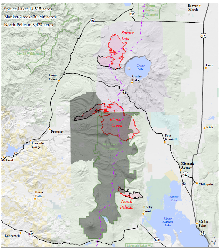

9-11-17 High Cascades Complex Fire Daily Update
For a downloadable, emailable PDF of this update, click here.
All OHV trails on the High Cascades Ranger District of the Rogue River-Siskiyou National Forest are now closed for public and firefighter safety. Additional closures remain in place on Rogue River-Siskiyou and Umpqua National Forests. For a complete list of wildfire-related closures go to: https://inciweb.nwcg.gov/incident/closures/5503/
Effective today, the Umpqua National Forest has lowered its Industrial Fire Precaution Level (IFPL) to III (partial shutdown). The Rogue River-Siskiyou National Forest remains under IFPL IV (general shutdown). For a complete description of IFPLs, visit https://tinyurl.com/ORIFPL
Northwest Incident Management Team 6 is now overseeing suppression of the High Cascades Complex West Zone, which consists of the Broken Lookout and Pup fires. The incident command post (ICP) will move from Diamond Lake to Joseph H. Stewart State Park tomorrow.
Yesterday’s Activity
Crews completed containment of a new lightning-started fire, originally thought to be a spot from the Pup Fire, and assisted the Rogue River-Siskiyou National Forest with initial attack on a second new start not related to the High Cascades Complex.
On the Broken Lookout Fire, crews made good progress preparing Forest Roads 6520, 2925 and 2947. Mop-up and chipping continued on the southern boundary along Forest Road 68. Helicopters supported protection of the Union Creek community by dropping water in the Woodruff Creek drainage to head off any potential eastward spread while crews continued prepping Forest Road 6510. A Level 1 evacuation notification remains in place for Union Creek.
Today’s Planned Activity
On the Pup Fire, firefighters will work to improve access via Forest Road 2940 and continue scouting containment line options.
Crews will continue strengthening lines on the eastern and southern boundaries of the Broken Lookout Fire, and developing a new line to the west along Forest Road 2925. Fire managers will also be exploring the potential for a smaller containment area now that contingency lines are established.
Weather
Today will be the hottest and driest since last week’s precipitation, stimulating more active fire behavior. Cooler, moister air will begin moving into the region tonight, bringing a chance of thunderstorms Tuesday.Quick Facts
Broken Lookout 16,606 acres, Containment: 20%
Incident Commander:
Shawn Sheldon
Resources on the fire:
Crews:8, Helicopters: 4, Engines: 14, Water Tenders: 7, Dozers: 3, Total Personnel: 638
Jurisdiction: Rogue River-Siskiyou NF, Umpqua NF
Jurisdiction: Rogue River‐ Siskiyou NF, Umpqua NF
Inciweb: https://inciweb.nwcg.gov/incident/5503
Facebook: https://www.facebook.com/R6RRSNF/
Twitter: https://twitter.com/RRSNF
Oregon Smoke Blog: http://oregonsmoke.blogspot.com/


09-11-17 High Cascades Complex Smoke Forecast
For a downloadable, emailable PDF of this update, click here
Smoke: Smoke production is expected to
increase today with moderate fire behavior. Winds from the north and northeast
will push smoke toward coastal areas including Gold Beach, Brookings and
further south into northern California. Highway 101 may see reduced visibility
in some areas. Periods of Unhealthy air may be experienced in coastal towns by
this afternoon /evening. Inland, in the Cave Junction, Grants Pass, Medford and
other Rogue Valley communities, moderate conditions this morning are expected
to worsen through the day, possibly reaching periods of unhealthy. This is due
to smoke from several regional fires impacting this zone.


9-10-17 High Cascades Complex Fire Daily Update

For a downloadable, emailable PDF of this update, click here.
Suppression
responsibility for the High Cascades Complex West Zone will transfer to the
Northwest Incident Management Team 6 on Monday. Northwest 7 IMT would like to
thank the communities of Union Creek and Prospect for their support the past three
weeks.
Yesterday’s
Activity: A spot fire was discovered on
the south flank of the Pup Fire in the Lone Prairie area. Ground and aerial resources
quickly contained it at one acre. Crews also made progress preparing the 2947
Road as a containment line on the western boundary. Point protection strategies
have been successful in preserving Hershberger Lookout.
On
the Broken Lookout Fire,
crews continued prep work on the north end of the 6510 Road. Burnout and mop‐up
operations continued on the southern boundary along the 68 Road. Fuels
reduction and road preparation continued along the west and north sections of
the fire perimeter. Air resources concentrated their efforts to check the fire’s
spread in the Woodruff Creek drainage to protect the community of Union Creek. Higher
humidity levels resulted in low to moderate rates of spread on both fires. Infrared
mapping showed the Broken Lookout Fire grew 1,200 acres and the Pup Fire grew
about 300 acres. A Level 1 evacuation notification remains in place for Union Creek.
Today’s
Planned Activity: On the Broken
Lookout Fire, crews will reinforce
containment lines along Forest Roads 68 and 29, while continuing indirect line
construction on Forest Roads 2925, 2947, 6510 and 6520. If conditions permit,
crews will use tactical firing operations to further secure the southeast flank
of the fire.
On
the Pup Fire, firefighters
will continue scouting opportunities to minimize spread outside the Rogue River‐Umpqua
Divide Wilderness Area using existing roads. Crews will also be mopping up the
spot fire contained yesterday.
Weather:
North/northwesterly winds
will shift to northeasterly in the evening, bringing warmer, drier air into the
region overnight and into Monday.
Closures:
Area closures are in place
for the Rogue Umpqua Divide Wilderness and surrounding National Forest lands by
both the Umpqua and Rogue River‐Siskiyou National Forests. Forest visitors
should familiarize themselves about these closures before they venture into the
area. For a complete list of closures see Inciweb at: https://inciweb.nwcg.gov/incident/closures/5503/
Quick Facts
Incident Summary
Approximate Size: Broken Lookout 16,606 acres and Pup 6,547 acres
Fire Containment: Broken Lookout 20% and Pup 5%
Incident Commander: Eric Knerr
Resources on the fire: Crews: 9 Helicopters: 4 Engines: 16 Water Tenders: 9 Dozers:
2
Total Personnel: 759
Jurisdiction: Rogue
River‐ Siskiyou NF, Umpqua NF
Inciweb: https://inciweb.nwcg.gov/incident/5503
Facebook: https://www.facebook.com/R6RRSNF/
Twitter: https://twitter.com/RRSNF
Oregon Smoke Blog: http://oregonsmoke.blogspot.com/


09-10-17 High Cascades Complex Smoke Forecast
For a downloadable, emailable PDF of this update, click here.
Smoke: Cooler weather and higher humidities over the fires has reduced smoke considerably. Fires are not as hot so smoke is drifting and settling close to the ground rather than rising in large plumes. Areas close to the fires are likely to continue to experience smoke impacts at times throughout the day as smoke moves around.


9-09-17 High Cascades West Zone Fire Daily Update
For a downloadable, emailable PDF of this update, click here.
Smoke Outlook: To see visibility in the area, check out the webcams on the Crater Lake National Park website https://www.nps.gov/crla/learn/photosmultimedia/webcams.htm. A full smoke report is posted on the Inciweb website.
The
High Cascades Complex is now being managed as two Zones. The West Zone consists of the Broken Lookout
and Pup Fires and continues to be managed by NWIMT 7. The East Zone is comprised of the Spruce Lake,
Blanket Creek and North Pelican Fires and is being managed by SWIMT 3. Updates will be produced for each Zone and
posted to Inciweb under the High Cascades Complex: https://inciweb.nwcg.gov/incident/5503
There are
numerous area, road and trail closures associated with the fires on the High
Cascades Complex issued by Crater Lake National Park and the Umpqua, Rogue
River-Siskiyou and Fremont-Winema National Forests. Firefighters and fire managers appreciate the
cooperation of the public in respecting the closures for their own safety and
the efficiency and effectiveness of the firefighting operations.
Yesterday’s
Activity:
On
the Broken Lookout Fire, crews neared completion of the containment line on the
southwest flank of the fire. Indirect
line construction continued along Forest Roads 2925, 6510 and 2947 to the west,
east and northeast of the main body of the fire respectively. The fire has not crossed Woodruff Creek and
continues to show little movement on its eastern flank and remains approximately
two miles from the community of Union Creek.
Union Creek remains at a Level 1 evacuation notification. Fire managers continue to assess containment
opportunities that will reduce the final footprint of the fire. The Pup Fire displayed little growth and was
again monitored. Point protection
tactics have been successful at Hershberger Lookout and it is still in place.
The
Blanket Creek Fire exhibited limited growth as crews continued to mop up the
southeast corner of the fire and assess suppression opportunities on the
southern flank within the Sky Lakes Wilderness.
On the Spruce Lake Fire contingency line preparation continued along the
North Entrance Road of Crater Lake National Park.
Today’s
Planned Activity: On the Broken Lookout Fire
crews will continue to prepare Forest Roads 2925, 68, 6510 and 6520 for future
containment lines. Tactical firing operations will proceed to further secure
the southeast flank of the fire if conditions permit. Helicopter bucket drops will be utilized to
check the fires spread in the Woodruff and Cougar Creek drainages as needed.
On
the Pup Fire firefighters will work to reopen Forest Road 6540 to provide
access to the eastern flank and continue to scout for containment opportunities
on the western flank.
Closures:
Area closures have been inacted for the Rogue Umpqua Divide
Wilderness and surrounding National Forest lands by both the Umpqua and Rogue
River-Siskiyou National Forests. Forest visitors should familiarize
themselves about these closures before they venture into the area. For
a complete list of closures see Inciweb at: https://inciweb.nwcg.gov/incident/closures/5503/
Smoke
Outlook: To
see visibility in the area, check out the webcams on the Crater Lake National
Park website https://www.nps.gov/crla/learn/photosmultimedia/webcams.htm.
A full smoke report is posted on the Inciweb website.
Smoke Outlook: To see visibility in the area, check out the webcams on the Crater Lake National Park website https://www.nps.gov/crla/learn/photosmultimedia/webcams.htm. A full smoke report is posted on the Inciweb website.
Quick Facts Incident Summary
Broken Lookout Approximate Size: 15,414
Pup Approximate Size: 6,271
Broken Lookout Fire Containment: 20%
Pup Fire Containment: 5%
Incident Commander: Eric Knerr
Resources on the fire: Crews: 6 Helicopters: 4 Engines: 10 Water Tenders: 9 Dozers: 2
Total Personnel: 425
Jurisdiction: Rogue River-Siskiyou NF, Umpqua NF
Inciweb: https://inciweb.nwcg.gov/incident/5503
Facebook: https://www.facebook.com/R6RRSNF/
https://www.facebook.com/SCOFMPFIREINFO/
Twitter: https://twitter.com/RRSNF
Joint Information Center: https://swojic.blogspot.com/
Oregon Smoke Blog: http://oregonsmoke.blogspot.com

09-09-17 High Cascades Smoke Forecast
For a downloadable, emailable PDF of this update, click here.
Smoke: Cooler weather and higher humidities over the fires has reduced smoke considerably although warming temperatures during the day today will increase fire activity and smoke. Areas close to the fires are likely to continue to experience smoke impacts at times throughout the day as smoke sloshes around.


9-08-17 High Cascades Daily Fire Update
For a downloadable, emailable PDF of this update, click here.
blanketcreekfireinfo@gmail
Today’s Planned Activity: Chipping may be completed along the west side of the North Entrance Road on the Spruce Lake Fire readying this containment line for future burnout should it become necessary. Firefighters on the Blanket Creek Fire will continue extending a containment line on the SE flank down to Sevenmile Canyon and doing burnout as conditions allow. Crews will mop-up and hold again along the west perimeter. Crews on the Broken Lookout Fire will continue prep work on the W perimeter along FR 2925 and on the NW along FR 2947. Firefighters will work to strengthen the established containment lines on the E and continue mop-up and use tactical firing along the mid-west flank as conditions warrant. Movement of the Pup Fire will be monitored.
Weather and Fire Behavior: The main pre-frontal upper disturbance that triggered thunderstorm activity on Wednesday and Thursday is gone but the upper trough is still along the coast. Therefore a chance of thunderstorms remains today. The weak frontal boundary will pass Saturday with breezier W-SW winds. Today will be cloudy to partly cloudy with temperatures in the mid to lower 70s and relative humidity at 34-50%. Active fire behavior has been modified for a day or two. Drying NE ridge winds return Sunday and will become stronger on Monday.
A Level 1 Evacuation Notification remains in effect for the Union Creek area in Jackson County Oregon, due to the Broken Lookout Fire. In addition, a Level 1 Evacuation Notification remains in effect for Mazama Village in Crater Lake National Park. Level 1 is the first step in the “Be Ready, Be Set, Go!” system. For more information about evacuation levels and procedures, go to http://tinyurl.com/BeReady-BeSet-Go.
The North Entrance Road to Crater Lake National Park remains closed due to a potential threat from the Spruce Lake Fire. The Park plans to host the fifth annual Ride the Rim event on Saturday, September 9th and re-open the North Entrance Road by Saturday morning. The West Rim Drive will re-open at 4 p.m. today for the weekend. Park officials will monitor fire conditions to ensure public safety and could re-close the roads should fire conditions pose a threat.
Smoke Outlook: A full smoke forecast can be viewed at: https://inciweb.nwcg.gov/incident/5503. To see visibility at Crater Lake National Park, check out the webcams at https://www.nps.gov/crla/learn/photosmultimedia/webcams.htm.
Closure Information: The entire Rogue-Umpqua Divide and Sky Lakes wilderness areas are closed to public entry due to the threat of wildfires. There are a number of additional area, road and trail closures in place within Crater Lake National Park, Rogue-River Siskiyou, Umpqua, and Fremont-Winema National Forests. For specific closure information, visit https://inciweb.nwcg.gov/incident/5503.
Inciweb: https://inciweb.nwcg.gov/incident/5503
Fire Information: (541) 316-8352
Cooler temperatures, higher relative humidity and wetting rains from passing thunderstorms provided relief again to firefighters yesterday in the complex. Precipitation was highest on Broken Lookout and Pup fires with up to 0.25” compared to Spruce Lake and Blanket Creek fires with as little as 0.05”. Decreased fire behavior and growth were the norm as a result of the moderated weather.
Agency administrators have decided to split management of the fires in the High Cascade Complex assigning suppression responsibility of the Broken Lookout and Pup Fires to the current NW Incident Management Team 7 and the Spruce Lake and Blanket Lake fires to Southwest (SW) Team 3. SW Team 3 will also take over management of the North Pelican Fire. Transfer of command is set to take place at 7 a.m. on September 9th.
Yesterday’s Activity: Fire crews on the Spruce Lake Fire (14,411 ac) continued chipping and hauling away material along the west side of the North Entrance Road. Fire managers evaluated containment options should the fire push further to the north. Crews and engines mopped up and patrolled the east perimeter burnout along FR 3282 from three days ago on the Blanket Creek Fire (30,750 ac). Firefighters prepped containment lines on the SE corner and installed a hose lay to support a burnout should that be needed in the future. This fire again showed little movement toward Mazama Village. Crews on the Broken Lookout Fire (15,414 ac) continued prepping the established containment lines on FR 6510, 6510-700, and 6520 to the E and on FR 2947 and 2947-300 tying to the Rogue Umpqua Divide Wilderness to secure the N-NE flank. Firefighters did mop-up along the fire’s edge along the mid-west perimeter and made good progress prepping FR 2925 on the W perimeter. This fire again showed little movement to the east towards Union Creek. Hershberger Lookout and adjacent telecommunications site remain unaffected by the Pup Fire (6,271 ac). A helicopter assigned to the Complex assisted the Oregon Department of Forestry with initial attack on a fire reported near Howard Prairie.
Quick Facts Incident Summary
Approximate Size: 66,966
Fire Containment:18%
Incident Commander: Eric Knerr
Resources on the fire: Crews: 16 Helicopters: 6 Engines: 17 Water Tenders: 14 Dozers: 4
Total Personnel: 649
Jurisdiction: Rogue River-Siskiyou NF, Crater Lake NP, Umpqua NF, Fremont-Winema NF
Approximate Size: 66,966
Fire Containment:18%
Incident Commander: Eric Knerr
Resources on the fire: Crews: 16 Helicopters: 6 Engines: 17 Water Tenders: 14 Dozers: 4
Total Personnel: 649
Jurisdiction: Rogue River-Siskiyou NF, Crater Lake NP, Umpqua NF, Fremont-Winema NF
Facebook: https://www.facebook.com/R6RRSNF/
https://www.facebook.com/SCOFMPFIREINFO/
Twitter: https://twitter.com/RRSNF
Joint Information Center: https://swojic.blogspot.com/
Oregon Smoke Blog: http://oregonsmoke.blogspot.com
09-08-17 High Cascades Smoke Forecast
For a downloadable, emailable PDF of this update, click here.
Smoke: Cooling weather and rain in some areas over the fires has reduced smoke considerably although areas near the fires are likely to continue to experience heavy smoke at times throughout the day. Air quality is expected to remain improved through tomorrow but warming and drying expected on Sunday could increase fire activity and smoke again. Cooling weather and rain in some areas over the fires has reduced smoke considerably although areas near the fires are likely to continue to experience heavy smoke at times throughout the day. Air quality is expected to remain improved through tomorrow but warming and drying expected on Sunday could increase fire activity and smoke again.


9-07-17 High Cascades Daily Fire Update
For a downloadable, emailable PDF of this update, click here.
A blanket of dense widespread smoke moderated all fires in the complex yesterday. Thunderstorms moved through the area on Wednesday afternoon with scattered thunder and lightning. The storms dropped scattered to moderate amounts of rain overnight and into Thursday morning bringing temporary relief to the fire behavior exhibited earlier in the week.
Yesterday’s Activity: Fire crews on the Spruce Lake Fire (13,601 ac) finished prepping and continued chipping along the west side of the North Entrance Road, the primary containment line on the NE flank. An engine crew patrolled along Hwy 230 looking for any spots as a result of the fire’s rapid spread Tuesday. Crews and engines held the eastern perimeter burnout along FR 3282 on the Blanket Creek Fire (29,154 ac) for the second consecutive day. Firefighters continued building handline on the SE corner of the fire to the wilderness boundary and evaluated containment options along the south. This fire again showed little movement toward Mazama Village. Crews on the Broken Lookout Fire (7,400 ac) made good progress again in strengthening the established containment lines on FR 6510, 6510700, and 6520 to the east. Firefighters continued prepping and tying FR 2947 and 2947-300 to the Rogue Umpqua Divide Wilderness to secure the N-NE flank. Firefighters completed prepping FR 29 on the NW perimeter and continued prep work on FR 2925 on the W perimeter. This fire has shown little movement to the east towards Union Creek. Fire crews continued prep work on FR 6540 in the Foster Creek drainage for containment of the Pup Fire (2,500 ac). All helicopters were grounded by the dense smoke over the complex.
Today’s Planned Activity: Chipping will continue along the west side of the North Entrance Road on the Spruce Lake Fire readying this containment line for future burnout should it become necessary. Firefighters on the Blanket Creek Fire will begin mopping up along the east flank, use dozers to cleanup constructed line in the SE corner, and continue constructing handline to the wilderness boundary. Crews will also locate and construct direct and indirect lines going further west along the southern perimeter. Engine crews will patrol the W flank of the fire. Crews on the Broken Lookout Fire will continue prep work on the W perimeter along FR 2925 and on the NW along FR 2947. Firefighters will work to strengthen the established containment lines on the E and also look for opportunities to build direct fireline in Woodruff Creek and on the mid-west flank. Movement of the Pup Fire will be monitored. Firefighters in the complex will be assisting the local Agencies on any initial attack needs from the many lightning strikes yesterday and overnight. Weather and Fire Behavior: An upper disturbance will bring cooler and moister conditions today with scattered thunderstorms to include heavy rain, small hail and outflow winds. The upper level disturbance will help to mix out the atmosphere a bit today and Friday. The prevailing afternoon westerly winds may contribute to areas of very active fire behavior where fuels remain dry. Showers and thunderstorms may continue Friday but most storms may shift to the east. A RED FLAG WARNING has been issued through 11 p.m. tonight due to the thunderstorms, erratic wind and potential flash flooding.
A Level 1 Evacuation Notification remains in effect for the Union Creek area in Jackson County Oregon, due to the Broken Lookout Fire. In addition, a Level 1 Evacuation Notification remains in effect for Mazama Village in Crater Lake National Park. Level 1 is the first step in the “Be Ready, Be Set, Go!” system. For more information about evacuation levels and procedures, go to http://tinyurl.com/BeReady-BeSet-Go.
The North Entrance Road to Crater Lake National Park remains closed due to a potential threat from the Spruce Lake Fire. West Rim Drive also remains closed for road construction and visitor safety until 4 p.m. on Friday. Motorists and visitors to the area also need to be aware of road construction activities on Hwy 230 between Union Creek and the junction with Hwy 138.
Outlook: A full smoke forecast can be viewed at: https://inciweb.nwcg.gov/incident/5503. To see visibility at Crater Lake National Park, check out the webcams at https://www.nps.gov/crla/learn/photosmultimedia/webcams.htm.
Closure Information: The entire Rogue-Umpqua Divide and Sky Lakes wilderness areas are now closed to public entry due to the threat of wildfires. There are a number of additional area, road and trail closures in place within Crater Lake National Park, Rogue-River Siskiyou, Umpqua, and Fremont-Winema National Forests. For specific closure information, visit https://inciweb.nwcg.gov/incident/5503.
9-07-17 High Cascades Complex Smoke Forecast
For a downloadable, emailable PDF of this update, click here.
9-06-17 High Cascades Daily Fire Update
Fire Information: (541) 316-8352
blanketcreekfireinfo@gmail.com
The entire Rogue-Umpqua Divide Wilderness is now closed to public entry. The Umpqua National Forest closed their remaining portion of the wilderness yesterday joining with the Rogue-River Siskiyou National Forest in providing for public safety due to the threat of wildfires.
Yesterday’s Activity: The unstable atmosphere, coupled with unseasonably hot and dry conditions again created a convection column and associated extreme fire behavior on Spruce Lake Fire (13,601 ac). The fire spread at about 2,000 feet/hour to the NW initially until a wind shift late in the afternoon caused the smoke column to collapse. The fire moved about ¾ of the way up Red Cone and has spread north to Bald Crater. Engine crews patrolled along Hwy 230 and 138 looking for any spots as a result of the fire’s rapid progression. Firefighters made good progress prepping and chipping along the west side of the North Entrance Road, the primary containment line on the NE flank. The burnout from Monday on the Blanket Creek Fire (29,154 ac) along FR 3282 on the east perimeter held very well. A 40 acre spot on the SE corner was tied back into the main fire with a dozer line. Helicopter bucket drops supported fire crews in holding the containment lines in place. An indirect line has been completed from FR 3282 to Hwy 62 north of Annie Creek Snopark and is ready for burnout if necessary. The fire has destroyed the Solus backcountry cabin. The southern edge of the Blanket Fire remains in the 2008 Middle Fork burn scar. All helicopters assigned to the Complex were relocated to the fueling station near Fort Klamath to take advantage of the clearer air and enhance air support. Crews on the Broken Lookout Fire (7,000 ac) again made good progress to strengthen the established containment lines on FR 6510, 6510-700, and 6520 to the east. A 40 acre spot of the SE corner was tied back in to the main fire with a dozer line. Firefighters used tactical burning along FR 68 to enhance containment in the midwest flank of the fire. Firefighters continued prepping and tying FR 2947 and 2947-300 to the Rogue Umpqua Divide Wilderness to secure the N-NE flank. Firefighters also began prepping FR 2925 on the W perimeter of the fire on the Umpqua N.F. side of the divide and on FR 2947 on the NW perimeter along Jackson Creek. This fire has shown little movement to the east towards Union Creek. Fire crews continued prep work on FR 6540 in Foster Creek for containment of the Pup Fire (2,500 ac).
Today’s Planned Activity: Firefighters will continue building handline on the SE corner of the Blanket Creek Fire to the wilderness boundary and scout/further evaluate containment options along the south. Engine crews will patrol the E and W flanks of the fire. Crews will continue prepping the west side of the North Entrance Road on the Spruce Lake Fire. Engine crews will patrol along Hwy 230 looking for any spots as a result of the fire’s spread on Tuesday. Crews on the Broken Lookout Fire will perform firing operations on the SE corner of the fire and continue to strengthen the established containment lines to the E. Crews will continue prep work on the W perimeter along FR 2925 and FR 2947 on the NW. Fire mangers are also evaluating FRs 64 and 6620 for containment on the W perimeter. Firefighters may begin tactical firing on the E flank of Pup Fire for containment.
Weather and Fire Behavior: An upper disturbance will bring cooler and moister conditions today and Thursday with scattered thunderstorms. Storms will be drier today as the lower air mass will take time to absorb moisture. As a result, the higher based thunderstorms may generate 2540 mph outflow winds. These conditions may contribute to periods of very active fire behavior especially on ridge tops and exposed areas and where continuous forest fuels line up with slope and winds. A RED FLAG WARNING has been issued due to the thunderstorms and erratic wind.
A Level 1 Evacuation Notification remains in effect for the Union Creek area in Jackson County Oregon, due to the Broken Lookout Fire. In addition, a Level 1 Evacuation Notification remains in effect for Mazama Village in Crater Lake National Park. Level 1 is the first step in the “Be Ready, Be Set, Go!” system. For more information about evacuation levels and procedures, go to http://tinyurl.com/BeReady-BeSet-Go.
The North Entrance Road to Crater Lake National Park remains closed due to a potential threat from the Spruce Lake Fire. West Rim Drive also remains closed for road construction and visitor safety until 4 p.m. on Friday. Motorists and visitors to the area also need to be aware of delays on Hwy 230 between Union Creek and the junction with Hwy 138 due to road construction.
Outlook: A full smoke forecast can be viewed at: https://inciweb.nwcg.gov/incident/5503. To see visibility at Crater Lake National Park, check out the webcams at https://www.nps.gov/crla/learn/photosmultimedia/webcams.htm.
Closure Information: As a result of the fires in the High Cascades Complex, a number of area, road and trail closures are in place within Crater Lake National Park, Rogue-River Siskiyou, Umpqua, and Fremont-Winema National Forests. For specific closure information, visit https://inciweb.nwcg.gov/incident/5503.
9-05-17 High Cascades Daily Fire Update
For a downloadable, emailable PDF of this update, click here.
For a downloadable, emailable PDF of this update, click here.
Fire Information: (541) 316-8352
blanketcreekfireinfo@gmail.com
The North Entrance Road to Crater Lake National
Park is now closed until further notice due to a
potential threat from the Spruce Lake Fire. West Rim Drive re-closed yesterday for road construction
and visitor safety until 4 p.m. on Friday. All concession operations remain operational
for visitors to the Park. Motorists and visitors to the area also need to
be aware of delays on Hwy 230 between Union Creek and the junction with Hwy 138
due to road construction.
Yesterday’s Activity: The unstable atmosphere, coupled with unseasonably hot and dry conditions
created convection columns and associated extreme fire behavior Monday on Paradise/Broken
Lookout/Windy Gap, Spruce Lake and Blanket Creek Fires. Paradise, Broken
Lookout, and Windy Gap Fires (7,500 ac) have grown together
and will now be called the Broken Lookout Fire. Crews made good progress
to strengthen the established containment lines on FR 6510, 6510-700, and 6520
to the east. This fire showed little movement to the east towards Union Creek. Firefighters
continued prepping and tying FR 2947 and 2947-300 north to the Rogue Umpqua
Divide Wilderness to secure the north-northeast flank. The Pup Fire (1,800
ac) moved further into Foster Creek and fire managers continued to evaluate
the best options for its containment. The Spruce Lake Fire (7, 300
ac) moved north of and onto Red Cone late Monday. Crews made good progress
prepping along the west side of the North Entrance Road, now the primary
containment line on the northeast flank. The Blanket Creek Fire (21,400 ac)
expanded to the south and east but largely away from Mazama Village and further
into the Sky Lakes Wilderness and the Middle Fork Fire scar from 2008. Helicopter bucket drops supported fire crews in
burnout on the Blanket Creek Fire along FR 3282 on the east and other
FRs on the southeast flank as they worked to achieve containment. Fire crews
made good progress on constructing an indirect line from FR 3282 to Hwy 62
north of Annie Creek Snopark. Air operations set-up a helicopter fueling
station near Fort Klamath and a heli-dip tank at Annie Creek Snopark. These new
options will greatly enhance the overall efficiency of air support.
Today’s Planned Activity: Crews on the Broken Lookout Fire will
continue to strengthen the established containment lines on FR 6510, 6510-700,
and 6520 to the east. Firefighters will also
be prepping FR 2925 on the west perimeter of the fire on the Umpqua National
Forest side of the divide and on FR 2947 on the northwest perimeter along
Jackson Creek. Firefighters will monitor the Pup Fire and do point
protection on the Hershberger Lookout and the adjacent telecommunication site. On
the Spruce Lake Fire firefighters will continue prepping and begin
chipping along the west side of the North Entrance Road in Crater Lake National
Park. Fire managers will also further evaluate reopening handlines used on the
2015 National Creek Complex for containment. Fire crews plan to complete the
burnout along containment lines on the south-southeast perimeter of the Blanket
Creek Fire if conditions allow and patrol the west perimeter to insure that
the fire stays in place along this flank. Crews may finish constructing
an indirect line from FR 3282 to Hwy 62 north of Annie Creek Snopark.
A Level 1 Evacuation Notification remains in
effect for the Union Creek area in Jackson County Oregon, due to fire activity from the Broken Lookout Fire. In addition, A
Level 1 Evacuation Notification remains in effect for Mazama Village
in Crater Lake National Park. Level
1 is the first step in the “Be Ready, Be Set, Go!” system. For more information about evacuation levels
and procedures, go to http://tinyurl.com/BeReady-BeSet-Go.
Weather and Fire Behavior: Hot, dry and very unstable
conditions persist today. Early dry SE ridgetop winds will shift to a NNW flow
in the afternoon on Spruce Lake and Blanket Creek Fires and shift to a SW-W flow on Broken Lookout and Pup Fires.
Potential afternoon isolated thunderstorms could produce erratic outflow winds.
These conditions may contribute to periods of very active fire behavior especially
on ridge tops and exposed areas and where continuous forest fuels line up with
slope and winds. Rapid heat build-up could result in group torching, crown
runs, and spotting. An increasing chance of afternoon/evening thunderstorms is
forecast for Wednesday into Thursday.
Smoke Outlook: A full
smoke forecast can be viewed at: https://inciweb.nwcg.gov/incident/5503. To see visibility at Crater Lake National Park, check
out the webcams at https://www.nps.gov/crla/learn/photosmultimedia/webcams.htm.
Closure Information: As
a result of the fires in the High Cascades Complex, a number of area, road and
trail closures are in place within Crater Lake National Park, Rogue-River
Siskiyou, Umpqua, and Fremont-Winema National Forests. For specific closure information, visit https://inciweb.nwcg.gov/incident/5503.
A Level 1 Evacuation Notification remains in effect for the Union Creek area in Jackson County Oregon, due to fire activity from the Broken Lookout Fire. In addition, A Level 1 Evacuation Notification remains in effect for Mazama Village in Crater Lake National Park. Level 1 is the first step in the “Be Ready, Be Set, Go!” system. For more information about evacuation levels and procedures, go to http://tinyurl.com/BeReady-BeSet-Go.
Weather and Fire Behavior: Hot, dry and very unstable conditions persist today. Early dry SE ridgetop winds will shift to a NNW flow in the afternoon on Spruce Lake and Blanket Creek Fires and shift to a SW-W flow on Broken Lookout and Pup Fires. Potential afternoon isolated thunderstorms could produce erratic outflow winds. These conditions may contribute to periods of very active fire behavior especially on ridge tops and exposed areas and where continuous forest fuels line up with slope and winds. Rapid heat build-up could result in group torching, crown runs, and spotting. An increasing chance of afternoon/evening thunderstorms is forecast for Wednesday into Thursday.
Smoke Outlook: A full smoke forecast can be viewed at: https://inciweb.nwcg.gov/incident/5503. To see visibility at Crater Lake National Park, check out the webcams at https://www.nps.gov/crla/learn/photosmultimedia/webcams.htm.
For a downloadable, emailable PDF of this map, click here.
 |
| High Cascades Public Information Map showing fire perimeter and closure areas |
Fires at a Glance
Approximate Size: 38,200 acres
Fire Containment: 20%
Incident Commander: Eric Knerr
ResourcesCrews: 14
Helicopters: 6
Engines: 25
Water Tenders: 16
Dozers: 2
Total Personnel: 617
Social Media ResourcesInciweb: https://inciweb.nwcg.gov/incident/5503
Facebook: https://www.facebook.com/R6RRSNF/
Twitter: https://twitter.com/RRSNF #HighCascadesComplex
Crater Lake National Park North Entrance and West Rim Drive Temporarily Closed
The North Entrance and West Rim
Drive of Crater Lake National Park are temporarily closed due to the
Spruce Lake Fire, part of the High Cascades Complex. Many hiking trails west of the lake are also closed due to fire activity. Most of the park remains open and is safe to visit, although smoky
skies and poor air quality are possible.
For more information visit Crater Lake's website at: www.nps.gov/crla
For more information visit Crater Lake's website at: www.nps.gov/crla
###
For a downloadable, emailable PDF of this update, click here.
Morning winds will be downslope/down valley out of the east. Afternoon winds will become upslope/up valley out of the west to northwest 2 to 7 mph with gusts in the afternoon to 15 mph. Diamond Lake, Crater Lake and communities east of the Cascades will see relief in the AM and early afternoon hours, however, by 2:00 heavy smoke is expected to return. Without a break in the inversion, weather is expected to be unfavorable for smoke dispersal. An inversion topping at 3000 to 5000 feet will hold smoke in and is unlikely to break. Under the inversion air quality will be particularly poor. A 20 percent chance of thunderstorm development is in the forecast for the fire area.

For additional information, please visit the web site at http://www.oregon.gov/deq.

9-05-17 High Cascades Complex Smoke Forecast
For a downloadable, emailable PDF of this update, click here.
Morning winds will be downslope/down valley out of the east. Afternoon winds will become upslope/up valley out of the west to northwest 2 to 7 mph with gusts in the afternoon to 15 mph. Diamond Lake, Crater Lake and communities east of the Cascades will see relief in the AM and early afternoon hours, however, by 2:00 heavy smoke is expected to return. Without a break in the inversion, weather is expected to be unfavorable for smoke dispersal. An inversion topping at 3000 to 5000 feet will hold smoke in and is unlikely to break. Under the inversion air quality will be particularly poor. A 20 percent chance of thunderstorm development is in the forecast for the fire area.

The Oregon Department of Environmental Quality has issued an Air Quality Alert in and around the outlook area and is in effect until further notice. Wildfires burning in the region combined with forecast conditions will cause air quality levels to fluctuate and could be at unhealthy levels.
For additional information, please visit the web site at http://www.oregon.gov/deq.
9-04-17 High Cascades Daily Fire Update
For a downloadable, emailable PDF of this update, click here.
For a downloadable, emailable PDF of this update, click here.
Fire Information: (541) 316-8352
blanketcreekfireinfo@gmail.com
Fire danger remains extreme and smoke in much of the area has become hazardous and unhealthy for the public and firefighters, and at the Incident Command Post south of Diamond Lake.
Fire danger remains extreme and smoke in much of the area has become hazardous and unhealthy for the public and firefighters, and at the Incident Command Post south of Diamond Lake.
Yesterday’s Activity:
The unstable atmosphere, coupled with unseasonably hot, dry conditions and a wind shift to the W-NW created convection columns and associated extreme fire behavior early afternoon on Sunday causing firefighters to pull back from containment lines on Paradise, Broken Lookout, Windy Gap and Blanket Creek Fires. As a result, spot fires to the south and west of Forest Road (FR) 68 and constructed dozer and hand line have fire managers re-assessing their primary containment line on the west perimeter of the Broken Lookout (5,080 ac), Windy Gap (817 ac) and Paradise (1,532 ac) Fires. Fire crews made good progress on strengthening the primary containment line along FR 6510 to help protect Union Creek from advancing fire. Crews also began prep work along FR 6510-700 as a secondary containment line west of FR 6510. Structural protection work has been completed in Union Creek. Firefighters started prepping and tying FR 2947 and 2947-300 to the Rogue Umpqua Divide Wilderness to the north to secure the northeast flank of the Paradise Fire. On Spruce Lake Fire (7,233 ac), fire crews were unable to hold the fire along the indirect containment line south of Red Cone. Firefighters then shifted their efforts to prepping along the west side of the North Entrance Road as the new primary containment line. The Blanket Creek Fire (21,284 ac) showed little movement towards Mazama Village to the north but very active fire behavior resulted in perimeter growth further into the Sky Lakes Wilderness to the south and to east crossing FR 3282. Hwy 62 is prepped and ready to be used as the containment line should intermediate efforts fail to contain the east perimeter. Good options have been identified on the east flank of the Pup Fire (1,734 ac) for indirect containment that will require minimal preparation. The persistent dense smoke at the Prospect Helibase again kept helicopters grounded. Efforts to establish a helicopter fueling station near Fort Klamath were unsuccessful due to dense smoke in the valley.
Today’s Planned Activity:
At Broken Lookout, Windy Gap and Paradise fires crews will work to strengthen the established containment lines on FR 6510, 6510-700, 2497 and 2497-300. Fire managers will continue to re-define their primary containment line on the west perimeter of the Broken Lookout, Windy Gap and Paradise Fires. As conditions allow, burnout operations will continue southeast along FR 68. Firefighters will monitor the Pup Fire and continue point protection on the Hershberger Lookout and the adjacent telecommunication site. On the Spruce Lake Fire crews will continue prepping along the North Entrance Road and reopening handlines used on the 2015 National Creek Complex. On Blanket Creek Fire, managers will reassess the use of FR 3282 as a primary containment line on the east flank and assess continued construction of line from FR 3282 south to Dry Creek then west to the Sky Lakes Wilderness boundary. Crews also plan to finish constructing an indirect line from FR 3282 to Hwy 62 north of Annie Creek Snopark.
A Level 1 Evacuation Notification remains in effect for the Union Creek area in Jackson County Oregon, due to fire activity from the Broken Lookout Fire. In addition, A Level 1 Evacuation Notification remains in effect for Mazama Village in Crater Lake National Park. Level 1 is the first step in the “Be Ready, Be Set, Go!” system. For more information about evacuation levels and procedures, go to http://tinyurl.com/BeReady-BeSet-Go.
Weather and Fire Behavior:Hot, dry and unstable conditions persist today. Early dry NE winds will shift to a NW flow in the afternoon again. An increasing chance of cloudiness and isolated afternoon/evening showers occurs Tuesday-Thursday. Very active fire behavior is possible especially on ridge tops and exposed areas and where continuous forest fuels line up with slope and winds. Rapid heat build-up could result in group torching, crown runs, and spotting.
Smoke Outlook:
A full smoke forecast can be viewed at: https://inciweb.nwcg.gov/incident/5503. To see visibility at Crater Lake National Park, check out the webcams at https://www.nps.gov/crla/earn/photosmultimedia/webcams.htm.
Crater Lake National Park West Rim Drive is open for Labor Day. The road will re-close at 9 p.m. tonight for road construction.
Closure Information:
As a result of the fires in the High Cascades Complex, a number of area, road and trail closures are in place within Crater Lake National Park, Rogue-River Siskiyou, Umpqua, and Fremont-Winema National Forests. For specific closure information, visit https://inciweb.nwcg.gov/incident/5503.
For a downloadable, emailable PDF of this map, click here.
 |
| High Cascades Public Information Map |
Fires at a Glance
Approximate Size: 37,500 acres
Fire Containment: 26%
Incident Commander: Eric Knerr
ResourcesCrews: 17
Helicopters: 6
Engines: 25
Water Tenders: 16
Dozers: 2
Total Personnel: 639
Social Media ResourcesInciweb: https://inciweb.nwcg.gov/incident/5503
Facebook: https://www.facebook.com/R6RRSNF/
Twitter: https://twitter.com/RRSNF #HighCascadesComplex
9-04-17 High Cascades Complex Smoke Forecast
For a downloadable, emailable PDF of this update, click here.
Smoke: Morning winds will be downslope/down valley out of the east. After 10:00 am winds will become upslope/up valley out of the west to northwest 2 to 7 mph with gusts in the afternoon to 15 mph. Weather is expected to be unfavorable for smoke dispersal. Air quality will be similar to the previous days particularly poor conditions. An inversion up to 4500 feet will hold smoke in and is unlikely to break.
The Oregon Department of Environmental Quality has issued an Air Quality Alert in and around the outlook area and is in effect until further notice. Wildfires burning in the region combined with forecast conditions will cause air quality levels to fluctuate and could be at unhealthy levels.
For additional information, please visit the web site at http://www.oregon.gov/deq.

9-03-17 High Cascades Daily Fire Update
For a downloadable, emailable PDF of this update, click here.
For a downloadable, emailable PDF of this update, click here.
Fire Information: (541) 316-8352
blanketcreekfireinfo@gmail.com
Fire danger remains extreme and smoke in much of the area has become hazardous and unhealthy for the public and firefighters, and at the Incident Command Post south of Diamond Lake.Yesterday’s Activity:
Although there were areas of very active fire yesterday, the dense smoke tempered potentially extreme fire behavior. The Blanket Creek Fire (12,734 ac) continued pushing further south/southeast into the 2008 Middle Fork Fire scar and backing further toward Mazama Village. Crews have almost finished the hand line to the northeast and chipping work was completed on Hwy 62. Firefighters are prepared to start burnout operations in this flank should the fire progress to that point. Spruce Lake Fire (6,907 ac) was active again and firefighters continued scouting for containment opportunities to the north and east of Red Cone. Firefighters worked to contain several small spot fires west of Broken Lookout Fire (4,893 ac)/Windy Gap Fire (804 ac). Prep work was completed along fire lines and FR 68 on the southwest and crews continued to clear and brush FR 6510 to help protect Union Creek from advancing fire. Structural protection work continued in Union Creek. A strategy was developed to secure the northeast flank of the Paradise Fire (1,134 ac) by prepping and tying FR 2947 to the Rogue Umpqua Divide Wilderness to the north. Good options have been identified on the east flank of the Pup Fire (1,734 ac) for indirect containment that will require minimal preparation. The persistent dense smoke at the Prospect Helibase kept helicopters grounded.
Today’s Planned Activity:
Air operations are working to establish a fueling station near Fort Klamath where the air has been consistently clearer. Air support is needed on all of the fires to slow forward spread, knock down flare ups, and allow crews and equipment to complete indirect containment lines. At the Blanket Creek Fire firefighters are ready to start burning along FR 3282 to stay ahead of the approaching fire as conditions allow. Crews are identifying options for indirect containment lines along trails and/or roads on the northeast flank between the leading edge of the fire and Mazama Village. On the Spruce Lake Fire crews will continue to look for opportunities to protect Red Cone. At Broken Lookout/Windy Gap/Paradise fires crews will work to strengthen established containment lines along FRs 68 and 6510 and constructed hand and dozer lines. As conditions allow, burnout operations will continue northwest along lines toward the Paradise Fire and southeast along FR 68. When completed, this will provide a blackened, more secure perimeter between these fires and Union Creek and areas further south. Firefighters will monitor the Pup Fire and continue point protection on the Hershberger Lookout and the adjacent telecommunication site.
A Level 1 Evacuation Notification remains in effect for the Union Creek area in Jackson County Oregon, due to fire activity from the Broken Lookout Fire. In addition, A Level 1 Evacuation Notification remains in effect for Mazama Village in Crater Lake National Park. Level 1 is the first step in the “Be Ready, Be Set, Go!” system. For more information about evacuation levels and procedures, go to http://tinyurl.com/BeReady-BeSet-Go.
Weather and Fire Behavior:
Hot and dry conditions persist today. A mixing unstable air mass remains above the fire complex with light terrain driven winds. There is an increasing chance of cloudiness and isolated afternoon/evening showers starting Monday. Again today smoke bottled up in the lower drainages may be a mitigating factor. Very active fire behavior is possible especially on ridge tops and exposed areas and where continuous forest fuels line up with slope and winds. Rapid heat build-up could result in group torching, crown runs, and spotting.
Smoke Outlook:
A full smoke forecast can be viewed at: https://inciweb.nwcg.gov/incident/5503. To see visibility at Crater Lake National Park, check out the webcams at https://www.nps.gov/crla/learn/photosmultimedia/webcams.htm.
Crater Lake National Park West Rim Drive is open for the Labor Day weekend. The road will re-close at 9 p.m. on Monday, September 4, for road construction. Motorists and visitors should drive defensively, as smoke may be present on roadways in the area.
Closure Information:
As a result of the fires in the High Cascades Complex, a number of area, road and trail closures are in place within Crater Lake National Park, Rogue-River Siskiyou, Umpqua, and Fremont-Winema National Forests. For specific closure information, visit https://inciweb.nwcg.gov/incident/5503.
For a downloadable, emailable PDF of this map, click here.

Fires at a Glance
Approximate Size: 28,326 acres
Fire Containment: 33%
Incident Commander: Eric Knerr
ResourcesCrews: 17
Helicopters: 6
Engines: 26
Water Tenders: 16
Dozers: 2
Total Personnel: 647
Social Media ResourcesInciweb: https://inciweb.nwcg.gov/incident/5503
Facebook: https://www.facebook.com/R6RRSNF/
Twitter: https://twitter.com/RRSNF #HighCascadesComplex
9-03-17 High Cascades Complex Smoke Forecast
For a downloadable, emailable PDF of this update, click here.
Smoke: Conditions will be similar to the previous day with some slight improvements. Morning winds will be out of the east. After 10:00 am winds will become west to northwest but will do little to clear smoke from the forecast area with the exception of Roseburg and Glide in the late afternoon/evening.
The Oregon Department of Environmental Quality has issued an Air Quality Alert in and around the outlook area and is in effect until further notice. Wildfires burning in the region combined with forecast conditions will cause air quality levels to fluctuate and could be at unhealthy levels.
For additional information, please visit the web site at http://www.oregon.gov/deq.

A public meeting was held in Union Creek on Friday, September 1, 2017 to provide information on the High Cascades Complex of Fires. To see more video highlights from the meeting, visit the Rogue River-Siskiyou Facebook page.
9-02-17 High Cascades Daily Fire Update
For a downloadable, emailable PDF of this update, click here.
For a downloadable, emailable PDF of this update, click here.
Fire Information: (541) 316-8352
blanketcreekfireinfo@gmail.com
Effective September 1, the
Fremont-Winema National Forest has expanded the area closure south and east of
the Blanket Creek Fire. The new closure is east of the Sky Lakes Wilderness to
Highway 62 on the Fremont-Winema National Forest and down to Sevenmile Marsh.
Closures are enacted for public and firefighter safety. For specific
information and a map of the closure area see: https://inciweb.nwcg.gov/incident/closures/5503/
Fire danger is extreme and
the public should use caution as they recreate in the out of doors. Fire
restrictions are in place on all public lands across SW Oregon.
Yesterday’s Activity: Hot, dry conditions increased fire activity Friday,
with smoke plumes forming on several fires within the High Cascades Complex.
After several days of being grounded by smoke, aviation resources were able to
resume support of suppression efforts. The Blanket Creek Fire (12,514 ac.)
continued pushing south and east. Crews continued building hand line in Crater
Lake NP and connect to a dozer line completed on the Fremont-Winema NF, and
prepping along Hwy. 62 between Mazama Village and Ft. Klamath. Early fire
activity on the Spruce Lake Fire (6,819 ac.) forced firefighters to alter their
plans for tactical burning south of Red Cone. Alternate indirect containment
lines were then scouted to the north and east of Red Cone. A spot fire crossed
a hand line on the southwest flank of the Windy Gap Fire (699 ac.) early in the
day, forcing firefighters to fall back to Forest Road 68 as the primary
containment line farther to the west. On the Broken Lookout Fire (4,651 ac.),
prep work was completed along FR 68 on the southwest flank and continued along
the east flank using FR 6510. Fuel reduction work continued and sprinklers were
positioned to protect the Union Creek community should they be needed. Fire
planners continued assessing potential containment opportunities for the Pup
Fire (1,564 ac.), located within the Rogue-Umpqua Divide Wilderness, which has
limited access and few natural containment barriers.
Today’s Planned Activity:
Plans are in place to merge the
Paradise (789 acres) and Windy Gap fires using tactical firing methods if
conditions allow. Firefighters should finish hand line construction on the east
flank of the Blanket Creek Fire and continue developing lines to the southeast
along FR 3282 and the adjacent road system. Burn out operations will commence
along FR 3282 if conditions permit. Aircraft will monitor the area between the
north edge of Blanket and Hwy. 62. Crews are further evaluating indirect
containment lines for the Spruce Lake Fire on the northeast flank by reopening
hand lines used on the 2015 National Creek Complex.
A Level 1 Evacuation
Notification remains in effect for the Union Creek area in Jackson County
Oregon, due to fire activity from the
Broken Lookout Fire. In addition, A Level 1 Evacuation Notification
remains in effect for Mazama
Village in Crater Lake
National Park. Level 1 is the first
step in the “Be Ready, Be Set, Go!” system. For more information about
evacuation levels and procedures, go to http://tinyurl.com/BeReady-BeSet-Go.
Weather and Fire Behavior: A ridge aloft and thermal trough near the surface over
SW Oregon moves inland today. Instability will couple with hot and dry
conditions to make for critical fire weather conditions today. Changing
conditions will bring a slight chance of isolated storms on Sunday, increasing
Monday through Wednesday, with possible new ignitions from lightning.
Smoke Outlook: A full smoke forecast can be viewed at: https://inciweb.nwcg.gov/incident/5503. To see visibility at Crater Lake National Park, check
out the webcams at https://www.nps.gov/crla/learn/photosmultimedia/webcams.htm.
Crater
Lake National Park West Rim Drive is open for the Labor Day weekend. The road
will re-close at 9 p.m. on Monday, September 4, for road construction. Motorists and visitors should drive defensively, as
smoke may be present on roadways in the area. Visitors should also expect
delays on Hwy 62 between Mazama Village and Fort Klamath due to firefighting
efforts.
Closure
Information: As a
result of the fires in the High Cascades Complex, a number of area, road and
trail closures are in place within Crater Lake National Park, Rogue-River
Siskiyou, Umpqua, and Fremont-Winema National Forests. For specific closure
information, visit https://inciweb.nwcg.gov/incident/5503.
For a downloadable, emailable PDF of this map, click here.

Fires at a Glance
Approximate Size: 27,321 acres
Fire Containment: 38%
Incident Commander: Eric Knerr
Resources
Crews: 15
Helicopters: 8
Engines: 26
Water Tenders: 13
Dozers: 2
Total Personnel: 663
Social Media Resources
Facebook: https://www.facebook.com/R6RRSNF/
9-01-17 High Cascades Daily Fire Update
For a downloadable, emailable PDF of this update, click here.
Fire Information: (541) 316-8352
blanketcreekfireinfo@gmail.com
There will be a community meeting at the amphitheater in Union Creek Campground tonight at 6 p.m. Fire managers and agency officials will discuss the status of the fires and planned operations.
A Level 1 Evacuation Notification remains in effect for the Union Creek area in Jackson County Oregon, due to fire activity from the Broken Lookout Fire. In addition, A Level 1 Evacuation Notification remains in effect for Mazama Village in Crater Lake National Park. Level 1 is the first step in the “Be Ready, Be Set, Go!” system. For more information about evacuation levels and procedures, go to http://tinyurl.com/BeReady-BeSet-Go.
Yesterday’s Activity
Total fire growth on the complex was moderate (980 acres). Blanket Creek Fire grew 288 acres (12,514 ac.) to the southeast. Primary containment line construction was started on the northeast flank using dozers on the Fremont-Winema National Forest and crews building handline in Crater Lake NP from Hwy 62 to the dozer line. Hand crews continued the prep work along Hwy 62. The Spruce Lake Fire grew 70 acres (6,819 ac.), primarily from tactical burning to tie the fire to the east-northeast containment line. An air tanker dropped “fugitive” retardant to check the movement of the fire towards Red Cone. Fugitive retardants contain a color pigment that degrades more quickly over time. Fire planners continued development of a containment strategy for the Pup Fire (1,564 ac.). Crews made good progress preparing the southern containment line for burnout along Forest Road (FR) 68 on the Broken Lookout (4,651 ac.) and Windy Gap (699 ac.) fires. Firefighters also burned out down the hand line along Cougar Butte trail to tie the Windy Gap to the Paradise Fire. On the eastern side of Broken Lookout, crews continued prep work along FR 6510 which is located between the fire and the Union Creek community. The west and north flanks of the Paradise Fire (789 acres) remain secure.
Today’s Planned Activity
Firefighters will work to complete the dozer and hand lines on the northeast flank of Blanket and tie to Hwy 62. Crews are also preparing indirect containment lines on the northeast flank, along FR 3282 and Hwy 62. Tactical firing operations will commence along FR 3282 if conditions permit. On the Spruce Fire, crews plan more tactical burning near the Red Cone area and will be mopping up along indirect fire line. At Union Creek, firefighters will continue to prepare the area from the advancing Broken Lookout Fire. Indirect line construction associated with the Broken Lookout and Windy Gap fires will continue along FRs 68 and 6510. Firefighters will again look for opportunities near Windy Gap to use tactical firing operations to tie it to Paradise fire. On the Paradise Fire, crews will continue holding and mopping up efforts. Fire planners are assessing containment options for the Pup Fire.
Weather and Fire Behavior
A ridge aloft and thermal trough near the surface over SW Oregon intensifies today into Saturday. East to northeast winds this morning will reinforce dry and warm air with overnight relative humidity recovery near critical lows. Heating towards 100 degrees is very possible today in places where smoke doesn't impede the sunshine. Atmospheric instability will start today and into Saturday. Dry NE winds today may lead to periods of very active fire behavior. A rapid buildup of heat could result in increased torching and spotting and activity along fire edges and within interior islands and ragged burn edges.
Smoke Outlook
A full smoke forecast can be viewed at: https://inciweb.nwcg.gov/incident/5503. To see visibility at Crater Lake National Park, check out the webcams at https://www.nps.gov/crla/learn/photosmultimedia/webcams.htm.
Crater Lake National Park West Rim Drive will open this afternoon at 4 p.m. for the Labor Day weekend. The road will re-close at 9 p.m. on Monday, September 4, for road construction. Motorists and visitors should drive defensively, as smoke may be present on roadways in the area. Visitors should also expect delays on Hwy 62 between Mazama Village and Fort Klamath due to firefighting efforts.
Closure Information
As a result of the fires in the High Cascades Complex, a number of area, road and trail closures are in place within Crater Lake National Park, Rogue-River Siskiyou, Umpqua, and Fremont-Winema National Forests. For specific closure information, visit https://inciweb.nwcg.gov/incident/5503. Closures are enacted for public and firefighter safety.
Due to continued hot, dry weather and widespread fire activity in SW Oregon, the Rogue River-Siskiyou NF is now prohibiting the use of any power saws and yarding. Firefighters are stretched thin to contain ongoing fires. Please do your part to help prevent new human-caused fires.
For a downloadable, emailable PDF of this map, click here.
 Fires at a Glance
For a downloadable, emailable PDF of this map, click here.

Approximate Size: 27,321 acres
Fire Containment: 38%
Incident Commander: Eric Knerr
Resources
Crews: 15
Helicopters: 8
Engines: 24
Water Tenders: 13
Dozers: 2
Total Personnel: 655
Social Media Resources
Facebook: https://www.facebook.com/R6RRSNF/
For a downloadable, emailable PDF of this update, click here.
Fire Information: (541) 316-8352
blanketcreekfireinfo@gmail.com
For a downloadable, emailable PDF of this update, click here.
Fire Information: (541) 316-8352
blanketcreekfireinfo@gmail.com
The Rogue-River Siskiyou National Forest has expanded
the area closure west of Hwy 62 and 230 around the Broken Lookout, Windy Gap,
Paradise and Pup fires. The area
generally runs from Woodruff Bridge on the south to the Rogue River-Siskiyou
and Umpqua National Forest boundary on the north. The new Closure also closes all
OHV trails on the High Cascades Ranger District. For specific information visit:
https://inciweb.nwcg.gov/incident/5503. Closures are enacted for public and firefighter
safety.
There will be a community meeting at the
amphitheater in Union Creek Campground on Friday, September 1 at 6 p.m. Fire managers and agency officials will discuss the status of the fires
and planned operations.
A Level 1 Evacuation Notification was issued yesterday for the Union
Creek area by the Jackson County Sheriff’s Office due to fire activity from the
Broken Lookout Fire. A Level 1 Evacuation Notification remains in
effect for Mazama Village in Crater Lake
National Park. Level 1 is the first step in the “Be Ready, Be Set, Go!”
system. For more information about
evacuation levels and procedures, go to http://tinyurl.com/BeReady-BeSet-Go.
Yesterday’s Activity
Fire expansion on the complex slowed yesterday. Blanket Creek Fire grew 331 acres (12,226 ac.)
to the southeast and hand crews have nearly completed the work along Hwy
62. The Spruce Lake Fire grew 65 acres (6,740
ac.), mainly from tactical burning to tie the fire to the east flank
containment line. Burnout operations
around Hershberger Lookout successfully protected the structures and radio
repeaters from the Pup Fire (1,410 ac.). Crews continued to prepare the southern
containment line for Broken Lookout (4,435 ac.) and Windy Gap (612 ac.) fires along
Forest Road 68. On the eastern side of
Broken Lookout, crews completed 2 miles of prep work along FR 6510 which is located
between the fire and the Union Creek community. The western portion of the fire line for the Paradise
Fire (789 acres) held in place. Helicopters
checked fires’ spread with water bucket drops.
Today’s Planned Activity
Two spike camps are being set up to reduce
driving distances and increase work productivity. One is at the Woodruff OHV Play Area on the
Rogue River-Siskiyou NF and the other is 2 miles south of Fort Klamath at the rodeo
grounds. Crews are preparing indirect containment
lines on the northeast flank of the Blanket Creek Fire, along FRs 390 and Hwy
62. Firefighters are also looking for
opportunities to reduce fire’s footprint and burn along FR 3282. On the Spruce Fire, crews plan more tactical
burning near the Red Cone area and will be mopping up along their indirect fire
line. At Union Creek, firefighters will
continue to prepare the area from the advancing Broken Lookout Fire. Indirect line construction associated with the
Broken Lookout and Windy Gap Fires will also continue along FRs 68 and 6510. Firefighters will also look for opportunities
near Windy Gap to burnout along FR 68. On the Paradise Fire, crews will continue
their holding and mopping up efforts on existing containment lines.
Weather and Fire Behavior
There is a Red Flag Warning from 8 p.m. tonight until 9 a.m. on Friday at higher elevations due to low relative humidity and strong east winds. Today will transition back to a hot and dry pattern. Upper elevations will see poor overnight humidity recovery. The dry NE winds today may lead to very active fire behavior. A rapid build-up of heat resulting in increased torching and spotting could result in increased activity along fire edges and within interior islands and ragged burn edges.
Smoke Outlook
A full smoke forecast can be viewed at: https://inciweb.nwcg.gov/incident/5503. To see visibility at Crater Lake National Park, check
out the webcams at https://www.nps.gov/crla/learn/photosmultimedia/webcams.htm. Crater Lake National Park West Rim Drive remains closed from Sunday
night to Friday afternoon for road construction. Motorists and
visitors also need to be aware of delays on Hwy 230 between Union Creek and the
junction with Hwy 138 due to road construction. There are also delays on Hwy 62 east of Mazama
Village on the road to Fort Klamath due to firefighting efforts.
Closure Information
As a result of the fires in the High Cascades
Complex, a number of area, road and trail closures are in place within Crater
Lake National Park, Rogue-River Siskiyou, Umpqua, and Fremont-Winema National
Forests. For specific closure
information, visit https://inciweb.nwcg.gov/incident/5503. Closures are enacted for public and firefighter
safety.
For a downloadable, emailable PDF of this map, click here.

Fires at a Glance
Approximate Size: 26,332 acres
Fire Containment: 37%
Incident Commander: Eric Knerr
Resources
Crews: 14
Helicopters: 7
Engines: 22
Water Tenders: 12
Dozers: 2
Total Personnel: 624
Social Media Resources
Facebook: https://www.facebook.com/R6RRSNF/
Twitter: https://twitter.com/RRSNF #HighCascadesComplex
A Level 1 Evacuation Notification was issued yesterday for the Union Creek area by the Jackson County Sheriff’s Office due to fire activity from the Broken Lookout Fire. A Level 1 Evacuation Notification remains in effect for Mazama Village in Crater Lake National Park. Level 1 is the first step in the “Be Ready, Be Set, Go!” system. For more information about evacuation levels and procedures, go to http://tinyurl.com/BeReady-BeSet-Go.
Weather and Fire Behavior
Smoke Outlook
Closure Information

8-30-17 High Cascades Complex Smoke Forecast
Winds will start out fairly light from the NE to SE direction. By afternoon they will shift W to NW with gusts developing by late afternoon, especially over higher terrain. This will push smoke east and again greatly impact the Rogue Valley, Cascades and communities along the east side of the Cascades. These westerly winds may provide some relief to Roseburg, Glide and Medford.
*The Oregon Department of Environmental Quality has issued an Air Quality Alert for the outlook area and is in effect until further notice. Wildfires burning in the region combined with forecast conditions will cause air quality levels to fluctuate and could be at unhealthy levels.
*The Oregon Department of Environmental Quality has issued an Air Quality Alert for the outlook area and is in effect until further notice. Wildfires burning in the region combined with forecast conditions will cause air quality levels to fluctuate and could be at unhealthy levels.

Rogue River-Siskiyou National Forest lifted the area closure around the Spruce Lake Fire at noon on Tuesday.
Yesterday’s Activity
The Blanket Creek Fire expanded another 1,400 acres (11,895 acres) towards Hwy 62 and further into the Sky Lakes Wilderness. Hand crews completed preparing defensible space around Mazama Village infrastructure and made good progress chipping and removing small trees, brush and debris along Hwy 62. The Spruce Lake Fire grew 910 acres (6,675 acres) moving further north towards the Pumice Desert. Crews completed some tactical burning around Hershberger Lookout due to continued growth of Pup Fire and continued to prep Forest Road 68 to head off the Broken Lookout (4,192 acres) and Windy Gap (390 acres) fires. Helicopters checked Broken Lookout fire’s spread east into Woodruff Creek with bucket drops. Structure protection assessments were initiated in the Union Creek area to evaluate and improve defensible space around infrastructure should the Broken Lookout Fire threaten this community.
Today’s Planned Activity
Crews will be prepping indirect lines on the Blanket Creek Fire on the northeast and Forest Roads 390 and 3282 and Hwy 62 to the east of the fire. These may be used as containment lines. Structure protection work (creating defensible space, installing hose lays, sprinklers and water pumps) will continue in Union Creek. Indirect line construction associated with the Broken Lookout and Windy Gap Fires will also continue along Forest Road 68 and 6510. Crews plan tactical burning to protect the Red Cone area from the Spruce Lake Fire and on Broken Lookout and Windy Gap Fires. On Paradise Fire, crews will be holding and mopping up existing containment lines on the north and west and checking fire spread in Cougar Creek. Helicopters, scooper aircraft and air tankers are available to help slow fire spread as smoke conditions allow.
Weather and Fire Behavior
A cool, dry trough will shift over the fires today. While temperatures will be slightly cooler (5-10 degrees lower than recent days) and relative humidity higher, the trough will serve to enhance and collect westerly winds with gusts to 25 to 30 mph by late afternoon into the evening. These stronger winds will overcome the otherwise milder conditions and result in another day of active to very active fire behavior. Spot fires could also occur up to a mile in front of the fire’s leading edges and contribute significantly to growth and spread. While the windy conditions will be a real test of containment lines, they may help to clear and disperse smoke around the fire areas. High pressure along with hotter and drier conditions is forecasted to return by Thursday.
A Level 1 Evacuation Notification remains in effect for Mazama Village in Crater Lake National Park. This is the first step in the “Be Ready, Be Set, Go!” system. For more information about evacuation levels and procedures, go to http://tinyurl.com/BeReady-BeSet-Go.
Smoke Outlook: A full smoke forecast can be viewed at: https://inciweb.nwcg.gov/incident/5503. To check visibility at Crater Lake National Park, check out the webcams at https://www.nps.gov/crla/learn/photosmultimedia/webcams.htm.
Crater Lake National Park West Rim Drive remains closed from Sunday night to Friday afternoon for road construction. Motorists and visitors need to be aware of delays on Hwy 230 between Union Creek and the junction with Hwy 138 due to road construction. There are also delays on Hwy 62 east of Mazama Village on the road to Fort Klamath due to firefighting efforts.
Closure Information
As a result of the fires in the High Cascades Complex, a number of area, road and trail closures are in place within Crater Lake National Park, Rogue-River Siskiyou, Umpqua, and Fremont-Winema National Forests. For specific closure information, visit https://inciweb.nwcg.gov/incident/5503. Closures are enacted for public and firefighter safety.
Joint Information Center (JIC)
Since SW Oregon is currently experiencing high fire activity, a JIC has been set up to help keep families safe and informed. JIC contact information: 541-608-1243 or swofireinfo@gmail.com A blog is also being maintained with detailed information: http://swojic.blogspot.com.

Fires at a Glance
Approximate Size: 25,231 acres
Fire Containment: 36%
Incident Commander: Eric Knerr
Resources
Crews: 16
Helicopters: 7
Engines: 24
Water Tenders: 12
Dozers: 2
Total Personnel: 589
Social Media Resources
Facebook: https://www.facebook.com/R6RRSNF/
Twitter: https://twitter.com/RRSNF #HighCascadesComplex
Current Situation
Crater Lake National Park West Rim Drive is now closed from Sunday night to Friday afternoon for road construction. Motorists and visitors to the area also need to be aware of delays on Highway 230 between Union Creek and the junction with Highway 138 due to road construction. There will also be delays on Highway 62 east of Mazama Village on the road to Fort Klamath due to firefighting efforts.
The Blanket Creek and Broken Lookout fires collectively grew approximately 2,000 acres yesterday. Due to the heavy smoke, aircraft were grounded. Because of the lack of air support and active burning conditions firefighters lost the opportunity to directly contain the Pup Fire (526 acres). An indirect strategy is now being developed.
Northwest Incident Management Team 7 is actively managing suppression of these fires as well as the Paradise, Windy Gap and Spruce Lake fires, which are located on parts of Crater Lake National Park and the Umpqua, Rogue River-Siskiyou and Fremont-Winema National Forests.
As a result of these fires, a number of area, road and trail closures are in place within the park and national forests. For specific closure information, visit https://inciweb.nwcg.gov/incident/5503. Closures are enacted for public and firefighter safety.
A Level 1 Evacuation Notification is still in effect for Mazama Village in Crater Lake National Park. This is the first step in the “Be Ready, Be Set, Go!” system. A Level 1 notification means park visitors and residents should be aware they could be asked to leave the area and “Be Ready” to do so. For more information about evacuation levels and procedures, go to http://tinyurl.com/BeReady-BeSet-Go

Yesterday’s Activity
The Blanket Creek Fire (10,493 acres) continued spreading east/southeast towards Highway 62 and further into the Sky Lakes Wilderness. Hand crews made good progress in preparing defensible space around Mazama Village infrastructure and chipping and removing small trees, brush and debris along Highway 62. The Spruce Lake Fire (5,765 acres) only expanded an additional 140 acres. Crews continued to prep Forest Road 68 to head off the Broken Lookout (3,728 acres) and Windy Gap (232 acres) fires. The Paradise Fire (568 acres) had minimal fire activity. The Sherwood Fire (77 acres) is in patrol status.
Today’s Planned Activity
Crews will be prepping indirect fire lines on the Blanket Creek Fire by clearing along hiking trails to the northeast of the fire and Highway 62. These are likely to be used as eventual containment lines. Indirect line construction associated with the Broken Lookout and Windy Gap Fires will also continue along Forest Road 68. The Spruce Lake Fire will continue to be monitored. If smoke conditions allow, helicopters, scooper aircraft and air tankers will be available to help check fire progression.
Weather and Fire Behavior
Today will be warm and dry. Winds may be similar to Monday and smoke will again permeate the area. Once again, high temperatures, low relative humidity, and marginally unstable atmosphere are expected to create active fire behavior today. Spot fires could readily ignite although persistent smoke may inhibit fire activity until later in the day.
Smoke Outlook and Closure Information
A full smoke forecast and detailed information about the area, road and trail closures associated with the fires on the High Cascades Complex can be viewed at: https://inciweb.nwcg.gov/incident/5503. To check visibility at Crater Lake National Park, check out the webcams at https://www.nps.gov/crla/learn/photosmultimedia/webcams.htm.
Joint Information Center (JIC)
Southwest Oregon is currently experiencing very high fire activity. With over 138,000 acres burning on forestlands the agencies have established a Joint Information Center (JIC) to serve as a ‘one-stop-shopping’ spot and help keep families safe and informed. The JIC can be contacted at: 541-608-1243 or swofireinfo@gmail.com. A blog is also being maintained with detailed information: http://swojic.blogspot.com
Fires at a Glance
Approximate Size: 21,432 acres
Fire Containment: 38%
Incident Commander: Eric Knerr
Resources
Crews: 18
Helicopters: 7
Engines: 22
Water Tenders: 12
Dozers: 2
Total Personnel: 610
Social Media Resources
Inciweb: https://inciweb.nwcg.gov/incident/5503
Facebook: https://www.facebook.com/R6RRSNF/
Twitter: https://twitter.com/RRSNF #HighCascadesComplex
8-29-17 High Cascades Complex Smoke Forecast
Light winds early in the day will provide little relief from conditions experienced Monday morning. In the afternoon smoke will push east of the fires with a stronger developing westerly wind. This may greatly impact the Rogue Valley, Cascades and communities along the east side of the Cascades. However, these westerly winds may provide some relief to Roseburg, Glide and Medford.

8-28-17 High Cascades Daily Fire Update
For a downloadable, emailable PDF of this update, click here.
Information Center: 541-316-8352
Email: blanketcreekfireinfo@gmail.com
Information Center: 541-316-8352
Email: blanketcreekfireinfo@gmail.com
Hotter, drier weather prompted more active fire behavior Sunday, with visible smoke columns and
higher intensity burning on several fires within the High Cascades Complex. The Blanket Creek and
Broken Lookout fires each grew approximately 1,000 acres.
A Level 1 Evacuation Notification has been issued for Mazama Village in Crater Lake National Park
as the Blanket Creek Fire continues moving toward Hwy. 62. This is the first step in the “Be Ready,
Be Set, Go!” system. A Level 1 notification means park visitors and residents should be aware they
could be asked to leave the area and “Be Ready” to do so. For more information about evacuation
levels and procedures, go to http://tinyurl.com/BeReady-BeSet-Go
The Broken Lookout and Lookout 2 fires merged and are expected to encompass the Windy Gap
fire soon. Northwest Incident Management Team 7 is actively managing suppression of these fires
as well as the Paradise, Pup, Blanket Creek and Spruce Lake fires, which are located on parts of
Crater Lake National Park and the Umpqua, Rogue River-Siskiyou and Fremont-Winema National
Forests.
As a result of these fires, a number of area, road and trail closures are in place within the park and
national forests. For specific closure information, visit https://inciweb.nwcg.gov/incident/5503.
Closures are enacted for public and firefighter safety.
Temperatures are expected to be slightly lower today, but still higher than normal. A drop in
humidity will increase fire activity in the afternoon. Additional fire spread is expected.
Yesterday’s Activity
The Blanket Creek Fire (9,299 acres) continued spreading eastward into the
2008 Middle Fork burn scar within Sky Lakes Wilderness and Crater Lake National Park. Ground
crews prepped defensible space and contingency lines around Mazama Village and along Hwy. 62.
The Spruce Lake Fire (5,625 acres) had more active burning within the interior but only grew 250 acres. Crews continued to prep Forest Road 68 to head off the Broken Lookout (3,134 acres) and Windy Gap (153 acres) fires.
Heavy smoke on the Pup Fire (201 acres) forced ground crews to withdraw, while aircraft continued to drop water on the leading edge of the fire. The Paradise Fire (421 acres) had minimal fire activity. The Sherwood Fire (77 acres) was completely contained and shifted to a patrol status.
Today’s Planned Activity
Flaggers will be directing traffic along Hwy. 62 within Crater Lake National Park today as crews continue prepping indirect fire lines on the Blanket Creek Fire. Indirect line construction associated with the Broken Lookout and Windy Gap Fires will also continue along Forest Road 68. Crews will resume building handlines around the Pup Fire. The Spruce Lake Fire will be monitored. Helicopters, scooper aircraft and air tankers will be available to assist ground crews by slowing the progression of the leading edges of the fires. Helicopters assigned to the High Cascades Complex may also be diverted to support other fires as needed.
For a downloadable, emailable PDF of this closure map, click here.

For a downloadable, emailable PDF of this IR overview map, click here.

Smoke Outlook and Closure Information
A full smoke forecast and detailed information about the area, road and trail closures associated with the fires on the High Cascades Complex can be viewed at: https://inciweb.nwcg.gov/incident/5503
To check visibility at Crater Lake National Park, check out the webcams at
Fires at a Glance
Approximate Size: 18,910 acres
Fire Containment: 44%
Incident Commander: Eric Knerr
Resources
Crews: 15
Helicopters: 8
Engines: 23
Water Tenders: 6
Dozers: 2
Total Personnel: 654
Social Media Resources
Inciweb: https://inciweb.nwcg.gov/incident/5503
Facebook: https://www.facebook.com/R6RRSNF/
Twitter: https://twitter.com/RRSNF #HighCascadesComplex
8-28-17 High Cascades Complex Smoke Forecast
For a downloadable, emailable PDF of this update, click here.
Smoke
ESE winds will provide relief in the early morning to communities on the east side of the Cascades. By mid-afternoon shifting winds will return to the forecast area out of the WSW moving smoke back over to the communities of Diamond Lake, Crater Lake and Prospect. This wind shift may bring some relief to Roseburg, Glide and Medford; however, nighttime settling will likely bring a return of smoky conditions.

For a downloadable, emailable PDF of this update, click here.
Fire Information: (541) 316-8352
Current Situation:
The High Cascades Complex now consists of the Paradise, Pup and Windy Gap fires, formerly
associated with the Falcon Complex on the Umpqua National Forest and the Blanket Creek, Spruce
Lake, Sherwood and Broken Lookout fires located within Crater Lake National Park and the Rogue
River-Siskiyou and Fremont-Winema National Forests.
Closures:
There are numerous area, road and trail closures associated with these fires issued by Crater Lake
National Park and the three National Forests. Firefighters and fire managers appreciate the
cooperation of the public in respecting the closures for their own safety and the efficiency and
effectiveness of the firefighting operations.
Weather/Fire Behavior:
Yesterday saw increased fire activity as the weather pattern began to warm and dry, with fire
perimeters spreading along unlined areas of the fires within the complex. Today’s weather is
forecast to be the hottest, driest and most unstable weather of the current pattern resulting in a
Red Flag Warning being issued for the entire complex area. Significant acreage increases are
possible on the uncontained perimeter of most fires within the complex.
Fires at a Glance:
The Blanket Creek Fire
(8,176 acres) continued spreading to the east within the Sky Lakes Wilderness and Crater Lake National Park. Aircraft dropping water were used to slow the growth of the head of the fire.
The Spruce Lake Fire
(5,381 acres) displayed minimal growth on the northeast flank as that fire burns into natural barriers. A crew completed a contingency line to the north of the fire intended to protect resources in the Red Cone vicinity of Crater Lake National Park.
The Sherwood Fire
(77 acres) is now completely lined and has been mopped up 100 feet from the perimeter. Firefighters engaged to build direct line around the Pup Fire (148 acres) located within the Rogue-Umpqua Divide Wilderness.
The Paradise Fire
The fire grew to 421 acres as firefighters held existing fire line established on the north
and west flanks and continued to construct line to the south.
Windy Gap & Broken Lookout Fires
Firefighters worked to establish indirect lines on the Windy Gap Fire (99 acres) and the Broken Lookout Fire (2,098 acres) located near each other on either side of the Rogue-Umpqua divide northeast of Huckleberry Gap in the Rogue Umpqua Divide Wilderness and Abbot Creek Research Natural Area. These two fires are expected to grow together in the near future.
For a downloadable, emailable PDF of this map, click here.

Today’s Planned Activity:
Crews will continue to work around structures in Mazama Village and prepare Highway 62 in the southeast corner of Crater Lake National Park as a future containment line for the Blanket Creek Fire. They will be doing the same type of work along Forest Road 68 in relation to the Windy Gap and Broken Lookout Fires. They will also continue to extend the established line on the west flank of the Paradise Fire toward Forest Road 68 to hold the west flank of that fire in check. They have completed the mop-up of the Sherwood Fire and have achieving 100% containment. Additional resources will be assigned to the Pup Fire with the goal of completing direct hand line around the fire. The Spruce Lake Fire will be monitored. Helicopters, scooper aircraft and air tankers will be available to assist ground crews as needed, provided smokey conditions does not hinder their use.
Smoke Outlook and Closure Information:
A full smoke forecast and detailed information about the area, road and trail closures
associated with the fires on the High Cascades Complex can be viewed at: https://inciweb.nwcg.gov/incident/5503
To check visibility at Crater Lake National Park, check out the webcams at
https://www.nps.gov/crla/learn/photosmultimedia/webcams.htm.
Quick Facts
Size: 16,400 acres
Containment: 60%
Incident Commander: Eric Knerr
Resources:
Crews: 18
Helicopters: 8
Engines: 28
Water Tenders: 21
Dozers: 3
Total Personnel: 856
Social Media Resources
Inciweb: https://inciweb.nwcg.gov/incident/5503
Facebook: https://www.facebook.com/R6RRSNF/
https://www.facebook.com/SCOFMPFIREINFO/
Twitter: https://twitter.com/RRSNF #HighCascadesComplex

For a downloadable, emailable PDF of this update, click here.
Fire Information: (541) 316-8352
Current Situation:
Northwest Incident Management Team 7 is now managing the Pup, Paradise, and Windy Gap Fires formerly included in the Falcon Complex. NW IMT 7 is now managing a total of 20 fires in Crater Lake National Park, Rogue River-Siskiyou, Fremont-Winema, and Umpqua National Forests. New closure orders have been issued by the Umpqua, Rogue River-Siskiyou, and Fremont Winema National Forests due to hazards associated with fire activity.
Closures:
Road, trail, and area closures have been expanded in and around the Abbott Creek Research Natural Area and the northern portion of the Sky Lakes Wilderness, including a portion of the Pacific Crest Trail. For maps and details see: https://inciweb.nwcg.gov/incident/closures/5503/, or see below.
Fires at a Glance:
Blanket Creek Fire
Start Date: July 26, 2017
Cause: Lightning
Size: 7,189 acres
Containment: 60%
Location: Approximately seven miles east of Prospect, Oregon
Status: Helicopters and aircraft continue to support ground operations. Active burning is expected with short range spotting. Hand crews are prepping in-direct line along Hwy. 62 in preparation for burnout operations. Motorists should watch for firefighters and equipment.
Spruce Lake Fire
Start Date: July 29, 2017
Cause: Lightning
Size: 5,314 acres
Containment: 60%
Location: West side of Crater Lake National Park
Status: Interior burning continues. Crews are building indirect line south of Red Cone.
Sherwood Fire
Cause: Under investigation
Size: 77 Acres
Containment: 90%
Location: Approximately six miles west of Diamond Lake near Sherwood Butte
Status: Crews are strengthening containment lines around the fire and mopping up hot spots.
Broken Lookout/Lookout 2 Fires
Cause: Lightning
Size: 1,534 Acres
Containment: 0%
Location: Approximately six miles west of the junction of Highways 62 and 230
Status: The Windy Gap and Paradise Fires will likely merge with the Broken Lookout Fire. Fire managers are planning an in-direct containment because of steep and difficult terrain.
Weather/Fire Behavior
The weather will become hotter and dryer with an increasing unstable and “mixing” air mass above the area. These conditions could lead to more active fire behavior and a potential for short range spotting. Isolated flare-ups are possible in areas that have not shown activity for a couple days.
Closures
Incident Closures: https://inciweb.nwcg.gov/incident/closures/5503/
Rogue River-Siskiyou National Forest Closures: https://www.fs.usda.gov/detail/rogue-siskiyou/
Crater Lake National Park Trail Closures: https://www.nps.gov/crla/planyourvisit/conditions.htm
Umpqua National Forest closures: https://www.fs.usda.gov/alerts/Umpqua/alerts-notices
Smoke Outlook
To see check visibility in the area, check out the webcams on the Crater Lake National Park website:
https://www.nps.gov/crla/learn/photosmultimedia/webcams.htm
Smoke
ESE winds will provide relief in the early morning to communities on the east side of the Cascades. By mid-afternoon shifting winds will return to the forecast area out of the WSW moving smoke back over to the communities of Diamond Lake, Crater Lake and Prospect. This wind shift may bring some relief to Roseburg, Glide and Medford; however, nighttime settling will likely bring a return of smoky conditions.

8-27-17 High Cascades Daily Fire Update
For a downloadable, emailable PDF of this update, click here.
Fire Information: (541) 316-8352
Current Situation:
The High Cascades Complex now consists of the Paradise, Pup and Windy Gap fires, formerly
associated with the Falcon Complex on the Umpqua National Forest and the Blanket Creek, Spruce
Lake, Sherwood and Broken Lookout fires located within Crater Lake National Park and the Rogue
River-Siskiyou and Fremont-Winema National Forests.
Closures:
There are numerous area, road and trail closures associated with these fires issued by Crater Lake
National Park and the three National Forests. Firefighters and fire managers appreciate the
cooperation of the public in respecting the closures for their own safety and the efficiency and
effectiveness of the firefighting operations.
Weather/Fire Behavior:
Yesterday saw increased fire activity as the weather pattern began to warm and dry, with fire
perimeters spreading along unlined areas of the fires within the complex. Today’s weather is
forecast to be the hottest, driest and most unstable weather of the current pattern resulting in a
Red Flag Warning being issued for the entire complex area. Significant acreage increases are
possible on the uncontained perimeter of most fires within the complex.
Fires at a Glance:
The Blanket Creek Fire
(8,176 acres) continued spreading to the east within the Sky Lakes Wilderness and Crater Lake National Park. Aircraft dropping water were used to slow the growth of the head of the fire.
The Spruce Lake Fire
(5,381 acres) displayed minimal growth on the northeast flank as that fire burns into natural barriers. A crew completed a contingency line to the north of the fire intended to protect resources in the Red Cone vicinity of Crater Lake National Park.
The Sherwood Fire
(77 acres) is now completely lined and has been mopped up 100 feet from the perimeter. Firefighters engaged to build direct line around the Pup Fire (148 acres) located within the Rogue-Umpqua Divide Wilderness.
The Paradise Fire
The fire grew to 421 acres as firefighters held existing fire line established on the north
and west flanks and continued to construct line to the south.
Windy Gap & Broken Lookout Fires
Firefighters worked to establish indirect lines on the Windy Gap Fire (99 acres) and the Broken Lookout Fire (2,098 acres) located near each other on either side of the Rogue-Umpqua divide northeast of Huckleberry Gap in the Rogue Umpqua Divide Wilderness and Abbot Creek Research Natural Area. These two fires are expected to grow together in the near future.
For a downloadable, emailable PDF of this map, click here.

Today’s Planned Activity:
Crews will continue to work around structures in Mazama Village and prepare Highway 62 in the southeast corner of Crater Lake National Park as a future containment line for the Blanket Creek Fire. They will be doing the same type of work along Forest Road 68 in relation to the Windy Gap and Broken Lookout Fires. They will also continue to extend the established line on the west flank of the Paradise Fire toward Forest Road 68 to hold the west flank of that fire in check. They have completed the mop-up of the Sherwood Fire and have achieving 100% containment. Additional resources will be assigned to the Pup Fire with the goal of completing direct hand line around the fire. The Spruce Lake Fire will be monitored. Helicopters, scooper aircraft and air tankers will be available to assist ground crews as needed, provided smokey conditions does not hinder their use.
Smoke Outlook and Closure Information:
A full smoke forecast and detailed information about the area, road and trail closures
associated with the fires on the High Cascades Complex can be viewed at: https://inciweb.nwcg.gov/incident/5503
To check visibility at Crater Lake National Park, check out the webcams at
https://www.nps.gov/crla/learn/photosmultimedia/webcams.htm.
Quick Facts
Size: 16,400 acres
Containment: 60%
Incident Commander: Eric Knerr
Resources:
Crews: 18
Helicopters: 8
Engines: 28
Water Tenders: 21
Dozers: 3
Total Personnel: 856
Social Media Resources
Inciweb: https://inciweb.nwcg.gov/incident/5503
Facebook: https://www.facebook.com/R6RRSNF/
https://www.facebook.com/SCOFMPFIREINFO/
Twitter: https://twitter.com/RRSNF #HighCascadesComplex
8-27-17 High Cascades Complex Smoke Forecast
For a downloadable, emailable PDF of this update, click here.
Smoke
ESE winds in the morning will cause periods of light impacts to communities on the west side of the Cascades, and pockets of light relief to communities on the east side. WSW winds are expected to return in the afternoon shifting regional smoke impacts back to the central portion of the Cascades. Expect settling smoke to pool in all valley communities in the evening.

8-26-17 High Cascades Daily Fire Update

Fire Information: (541) 316-8352
Current Situation:
Northwest Incident Management Team 7 is now managing the Pup, Paradise, and Windy Gap Fires formerly included in the Falcon Complex. NW IMT 7 is now managing a total of 20 fires in Crater Lake National Park, Rogue River-Siskiyou, Fremont-Winema, and Umpqua National Forests. New closure orders have been issued by the Umpqua, Rogue River-Siskiyou, and Fremont Winema National Forests due to hazards associated with fire activity.
Closures:
Road, trail, and area closures have been expanded in and around the Abbott Creek Research Natural Area and the northern portion of the Sky Lakes Wilderness, including a portion of the Pacific Crest Trail. For maps and details see: https://inciweb.nwcg.gov/incident/closures/5503/, or see below.
Fires at a Glance:
Blanket Creek Fire
Start Date: July 26, 2017
Cause: Lightning
Size: 7,189 acres
Containment: 60%
Location: Approximately seven miles east of Prospect, Oregon
Status: Helicopters and aircraft continue to support ground operations. Active burning is expected with short range spotting. Hand crews are prepping in-direct line along Hwy. 62 in preparation for burnout operations. Motorists should watch for firefighters and equipment.
Spruce Lake Fire
Start Date: July 29, 2017
Cause: Lightning
Size: 5,314 acres
Containment: 60%
Location: West side of Crater Lake National Park
Status: Interior burning continues. Crews are building indirect line south of Red Cone.
Sherwood Fire
Cause: Under investigation
Size: 77 Acres
Containment: 90%
Location: Approximately six miles west of Diamond Lake near Sherwood Butte
Status: Crews are strengthening containment lines around the fire and mopping up hot spots.
Broken Lookout/Lookout 2 Fires
Cause: Lightning
Size: 1,534 Acres
Containment: 0%
Location: Approximately six miles west of the junction of Highways 62 and 230
Status: The Windy Gap and Paradise Fires will likely merge with the Broken Lookout Fire. Fire managers are planning an in-direct containment because of steep and difficult terrain.
Weather/Fire Behavior
The weather will become hotter and dryer with an increasing unstable and “mixing” air mass above the area. These conditions could lead to more active fire behavior and a potential for short range spotting. Isolated flare-ups are possible in areas that have not shown activity for a couple days.
Closures
Incident Closures: https://inciweb.nwcg.gov/incident/closures/5503/
Rogue River-Siskiyou National Forest Closures: https://www.fs.usda.gov/detail/rogue-siskiyou/
Crater Lake National Park Trail Closures: https://www.nps.gov/crla/planyourvisit/conditions.htm
Umpqua National Forest closures: https://www.fs.usda.gov/alerts/Umpqua/alerts-notices
Smoke Outlook
To see check visibility in the area, check out the webcams on the Crater Lake National Park website:
https://www.nps.gov/crla/learn/photosmultimedia/webcams.htm
No comments:
Post a Comment
Note: Only a member of this blog may post a comment.